AUTOMATIC IDENTIFICATION SYSTEM AIS system Class A IEC


 Concept")


 • Maritme Cloud")


- Slides: 40
AUTOMATIC IDENTIFICATION SYSTEM
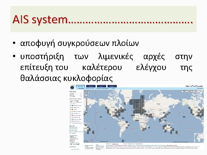
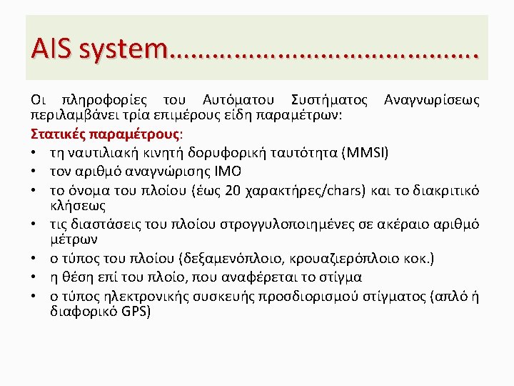
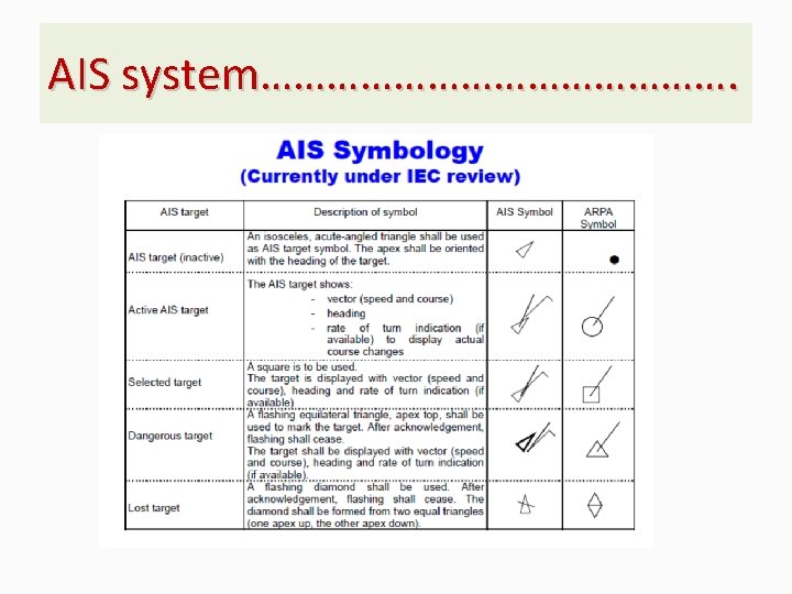
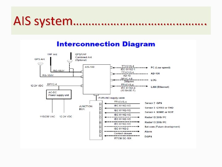
AIS system…………………. Class A | IEC 61993 -2 • Shipborne mobile equipment intended to meet the performance standards and carriage requirements adopted by IMO. Class A stations report their position (message 1/2/3) autonomously every 2 -10 seconds dependent on the vessel’s speed and/or course changes (every three minutes or less when at anchor or moored); and, the vessel’s static and voyage related information (message 5) every 6 minutes. • Class A stations are also capable of text messaging safety related information (message 6/8) and AIS Application Specific Messages (message 6, 8, 25, 26), such as meteorological and hydrological data, electronic Broadcast Notice to Mariners, and other marine safety information (see IMO Safety of Navigation Circular 289, GUIDANCE ON THE USE OF AIS APPLICATION-SPECIFIC MESSAGES (ASM) or the IALA Application Specific Message Collection).
AIS system…………………. Class Β| IEC 62287 -1 & 62287 -2 • Shipborne mobile equipment which is interoperable with all other AIS stations, but, does not meet all the performance standards adopted by IMO. Similar to Class A stations, they report every three minutes or less when at anchor or moored, but, their position (message 6/8) is reported less often and at a lower power. Likewise, they report the vessel’s static data (message 18/24) every 6 minutes, but, not any voyage related information. They can receive safety related text and application specific messages, but, cannot transmit them. • There are two types of Class B AIS, those using carrier sense Time-Division Multiple Access (CS-TDMA) technology and those like the Class A using Self -Organizing Time-Division Multiple Access Technology (SO-TDMA). Class B/SO is generally more capable; Class B/CS is generally less expensive
AIS system…………………. • VDES (VHF Data Exchange System) Concept
AIS system…………………. • Γιατί απαιτείται ένα νέο AIS πρωτόκολλο AIS for Recreational Boaters benefits all • The MMSI scheme was designed in the 1970’s for integration with telex exchanges – US number available are <999, 999 – Over 17 million Recreational Boaters • AIS Class A was originally designed as a collision avoidance system – Tailored for High Seas Vessels – VHF TDMA Bandwidth is approaching saturation • The existing AIS A & B system would fail if used by the general recreational boating public
AIS system…………………. Class Ε| Smart Chart AIS A Test-Bed for AIS • The So What – A DHS Sponsored SBIR Project • The ability to track small vessels in an asymmetric threat environment is critical to maritime security, but not easily accomplished due to the sheer volume of craft and the range of environments which they operate within. The introduction of smartphones with location, orientation, camera, and Internet capabilities enables cooperative vessel tracking at levels previously unachievable. • Technology / Product • Smart Chart AIS smart phone software provides NOAA charts and additional services free of charge to recreational boaters. This software will also enable these users to benefit from Automatic Identification System (AIS) like services normally restricted to larger vessels. • Smart Chart AIS is a prototype for AIS Class E
AIS system…………………. Χαρακτηριστικά • Smart Chart AIS combines: – Electronic Charts – Automatic Identification System (AIS) over cellular networks – Augmented Reality – Social Networking • Smart Chart AIS runs on Smart Phones and Tablets • FREE to end users! – Android Released, i. Phone in Beta
AIS system…………………. • Διαγράμματα και Επικαλύψεις Electronic Charts are provided by NOAA’s Direct ENC Servers • Core Chart Capability is Arc. GIS based –Also supports satellite, streets, etc. –Any Arc. GIS based content can be added as an overlay, e. g. NEXRAD weather
AIS system…………………. • Ανάπτυξη AIS class E Operates over Cellular Networks Provides both User and Vessel Identification Also supports viewing AIS Class A & B Traffic sourced from AISHub. net
AIS system…………………. • Active Captain provides a wealth of cruising information. �It requires a free Active. Captain user account, which can be obtained at Active. Captain. com. The Active. Captain menu enables toggling of optional Markers: - Marinas - Anchorages - Local Knowledge - Hazards
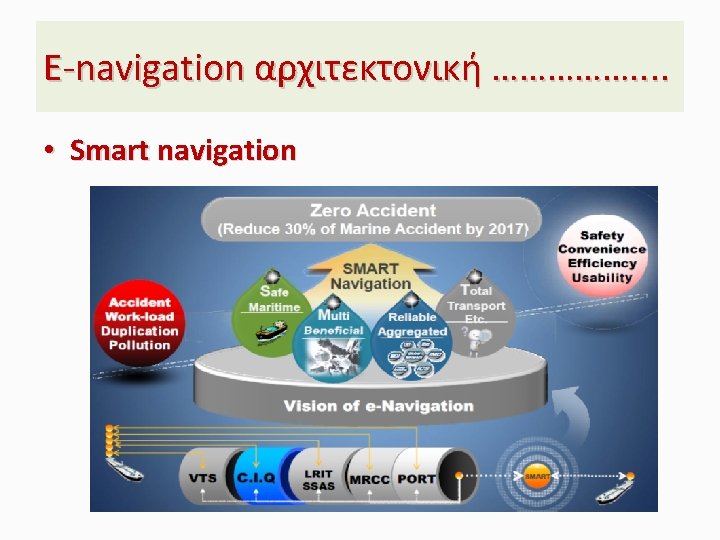
AIS system…………………. Μελλοντικές Εφαρμογές • E-navigation • Marine Electronic Highways (MEH) • Maritme Cloud • Smart navigation • Data integration • Pico satellites and AIS
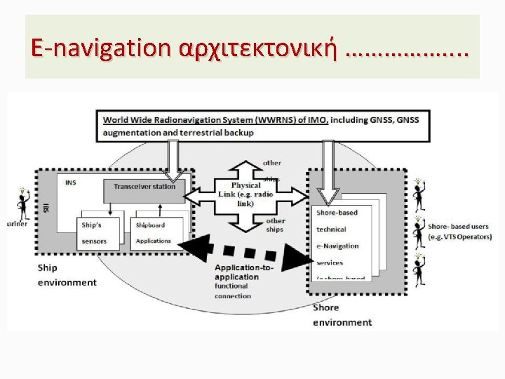
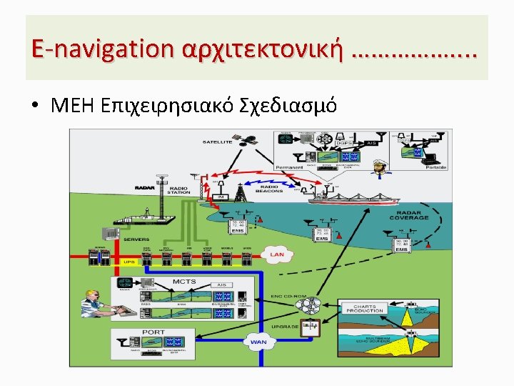
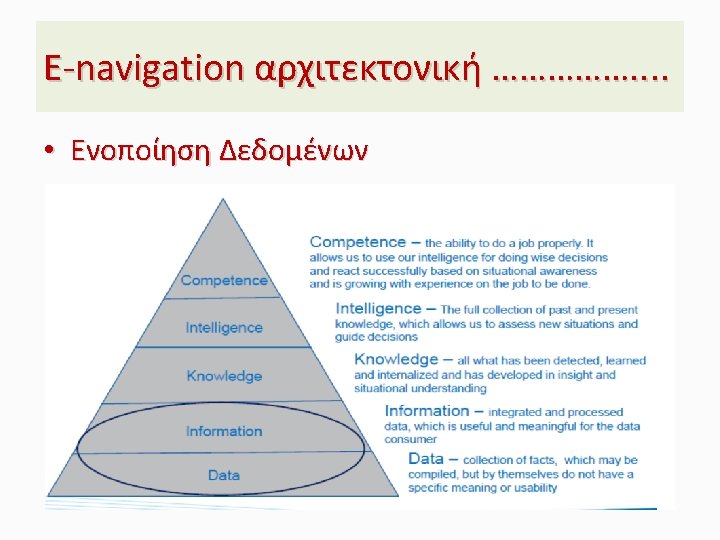
Ε-navigation αρχιτεκτονική ……………. . • Building Blocks of Marine Electronic Highway
Ε-navigation αρχιτεκτονική ……………. . • Maritime cloud concept
Ε-navigation αρχιτεκτονική ……………. . • Software quality and HCD
Ε-navigation αρχιτεκτονική ……………. . • VESSEL OPERATION IN E-NAVIGATION
MONITORING AND SEARCH AND RESCUE
Monitoring and Search and Rescue. . • Polar navigation