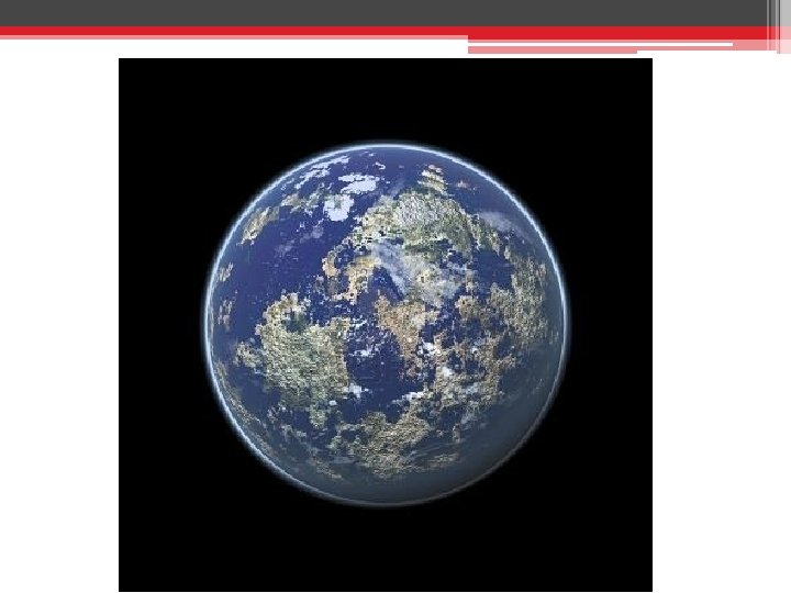
Atmosphere Weather Maps Currents What is the atmosphere


![Troposphere [turning] ~ 20 km Equator ~ 17 km Average ~ 7 km N/S](https://slidetodoc.com/presentation_image_h/09cb57bec8e5b05373d75ea9b8384438/image-5.jpg "Troposphere [turning] ~ 20 km Equator ~ 17 km Average ~ 7 km N/S")
![Stratosphere [distinct layers] Altitude Begins around -52°C around base goes up to -3°C at](https://slidetodoc.com/presentation_image_h/09cb57bec8e5b05373d75ea9b8384438/image-7.jpg "Stratosphere [distinct layers] Altitude Begins around -52°C around base goes up to -3°C at")
![Mesosphere [middle] Altitude ~ 50 km to 85 km Begins around -3°C around base](https://slidetodoc.com/presentation_image_h/09cb57bec8e5b05373d75ea9b8384438/image-9.jpg "Mesosphere [middle] Altitude ~ 50 km to 85 km Begins around -3°C around base")
![Thermosphere [heat] Altitude ~ 80 km to 500 -1000 km Begins around -200°C and](https://slidetodoc.com/presentation_image_h/09cb57bec8e5b05373d75ea9b8384438/image-10.jpg "Thermosphere [heat] Altitude ~ 80 km to 500 -1000 km Begins around -200°C and")
![Ionosphere [ion] Altitude 80 km to 550 km LOWER Level of Thermosphere The ions](https://slidetodoc.com/presentation_image_h/09cb57bec8e5b05373d75ea9b8384438/image-12.jpg "Ionosphere [ion] Altitude 80 km to 550 km LOWER Level of Thermosphere The ions")
![Magnetosphere [magneto] Altitude Midrange inside of the Thermosphere - VAN ALLEN Radiation Belts -](https://slidetodoc.com/presentation_image_h/09cb57bec8e5b05373d75ea9b8384438/image-13.jpg "Magnetosphere [magneto] Altitude Midrange inside of the Thermosphere - VAN ALLEN Radiation Belts -")

![Exosphere [outer] Altitude 550 km to 190, 000 km OUTER Level of Thermosphere –](https://slidetodoc.com/presentation_image_h/09cb57bec8e5b05373d75ea9b8384438/image-16.jpg "Exosphere [outer] Altitude 550 km to 190, 000 km OUTER Level of Thermosphere –")

 • Nitrogen ▫ Most abundant element in the atmosphere.")


")


 Draw a weather symbol with ▫ ½ cloud cover ▫ wind")
 Draw a weather symbol with ▫ 60% cloud cover ▫ wind")


- Slides: 110
Atmosphere, Weather, Maps, Currents
• What is the atmosphere? • Why is the sky blue?
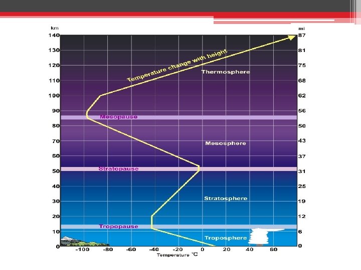
Troposphere [turning] ~ 20 km Equator ~ 17 km Average ~ 7 km N/S Poles Temperature Begins near 17°C around base and down to -52°C at top - 99% of the WATER VAPOR in the atmosphere - Drives the Water Cycle - 75% of the mass of the atmosphere - All WEATHER occurs in this level
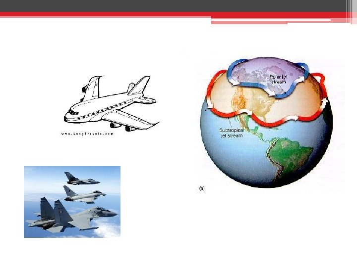
Stratosphere [distinct layers] Altitude Begins around -52°C around base goes up to -3°C at top ~ 10 to 50 km - PLANES FLY at bottom of this level to ~ 13 – 20 km avoid turbulence, maximize jet fuel, Ozone Layer and avoid storms. - JET Stream is located (winds of 198 mph)
Mesosphere [middle] Altitude ~ 50 km to 85 km Begins around -3°C around base goes down to -100°C THE COLDEST LAYER - Too high for aircraft but too low for orbiting spacecraft - POOREST Understood region - Most METEORS burn up in this range
Thermosphere [heat] Altitude ~ 80 km to 500 -1000 km Begins around -200°C and then up to 1500+°C The Highest Temperature Layer - Temperature would ‘feel’ COLD to us because there are so few molecules, even though they have a HIGH level of energy.
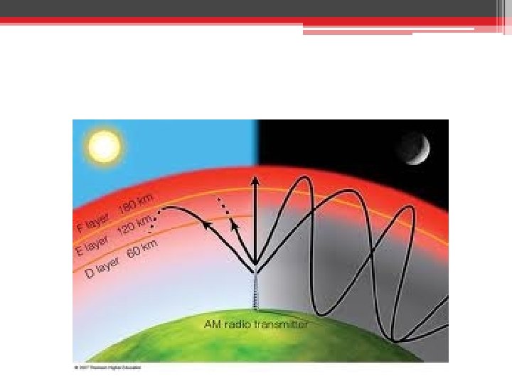
Ionosphere [ion] Altitude 80 km to 550 km LOWER Level of Thermosphere The ions here bounce radio waves back to Earth. Solar flares can increase the ion levels here and cause interference with radio transmission (one source of that static sound you hear)
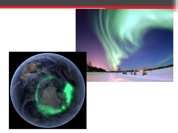
Magnetosphere [magneto] Altitude Midrange inside of the Thermosphere - VAN ALLEN Radiation Belts - Made up of 1000 km to about positively charged protons and negatively 4000 km charged electrons, given off by the sun, and captured by the Earth’s magnetic field - AURORAE - Collisions of these particles cause light energy to be given off, called Aurora Borealis (Northern Lights).
Aurora Borealis • Steamed Hams?
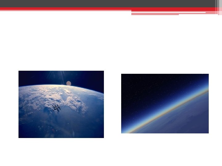
Exosphere [outer] Altitude 550 km to 190, 000 km OUTER Level of Thermosphere – extends into “space” - The particles are so spread out that they are likely to not hit any other molecules - ARTIFICIAL SATELLITES orbit the earth up here. International Space station, weather, television, and telephone satellites
Greek Roots • • • Sphere – Ball Hemi – Half Atmo – Air Litho – Stone Bio – Life Meso – Middle Exo – Outer Thermo – Heat Strat - Stratify Trop - Turning Ion – Ion
Atmospheric Elements (% and Movie) • Nitrogen ▫ Most abundant element in the atmosphere. – 78. 1% ▫ Makes proteins in animals and plants • Oxygen ▫ Second most abundant element = 20. 8% ▫ Plants = Give off O 2 as waste. ▫ Animals = Take in O 2 to produce food. • CO 2 ▫ Plants = Take in CO 2 to produce food. ▫ Animals = Give off CO 2 and Nitrogen as waste. Too Much CO 2 in the atmosphere = Too much greenhouse effect • Ozone ▫ Found in the stratosphere ▫ Blocks UV radiation = good
Air Pressure • The result of the weight of a column of air pushing on an area
Air Pressure • Measured with a barometer • Aneroid / mercury
HEAT Radiation Conduction Convection
Convection • The transfer of energy by the bulk movement of molecules and differences in density. Or – Transfer of heat through fluid Density Mass / Volume The amount of stuff in a given space.
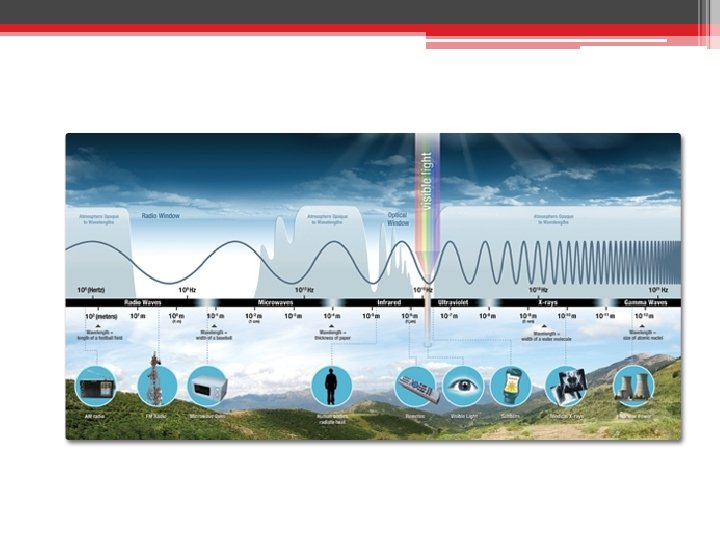
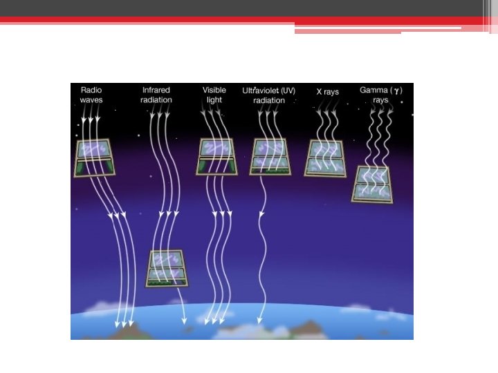
The Electromagnetic Spectrum
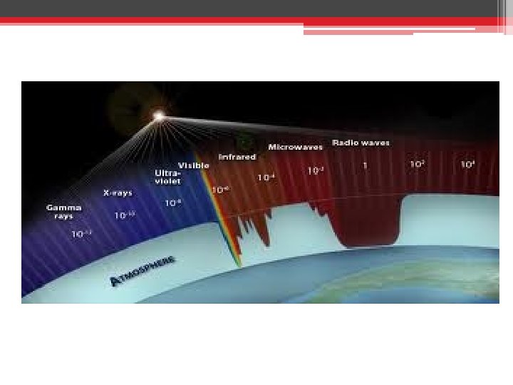
Solar Radiation entering the Atmosphere Lower Energy Long-wave Radiation A – Blocked by our atmosphere A High Energy Short-wave Radiation B – Blocked by our atmosphere B F C Visible Light C = Absorbed by atmosphere D = Absorbed by the Earth E = Reflected by Earth F = Reflected by Clouds E D
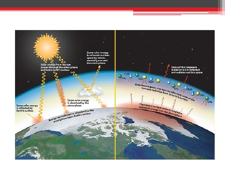
Greenhouse Effect
Greenhouse Effect A – Incoming Shortwave Radiation that warms earth B – Long-wave Radiation emitted from Earth C C – Some Long-wave Radiation escapes atmosphere D – Some Long-wave Radiation is reflected back to Earth THIS STEP IS THE GREENHOUSE EFFECT D A B
On Earth the Greenhouse Effect Incoming shortwave radiation from the sun, makes it thru CO 2 in the atmosphere Outgoing long-wave radiation from the earth, does not make it thru CO 2
Greenhouse Gases • Which is the most prevalent greenhouse gas? ▫ H 2 O ▫ CO 2 ▫ CH 4
Weather Notes
Direct Heating vs. Indirect Heating
Creation of North/South Winds
The Coriolis Effect • The earth spins faster at the equator than the poles, and therefore winds don’t travel at the same rate in a vertical path. • Winds therefore bend towards either east/west.
Creation of East/West Winds Easterlies Westerlies Trade Winds
Uneven heating of surfaces
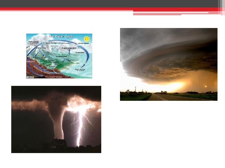
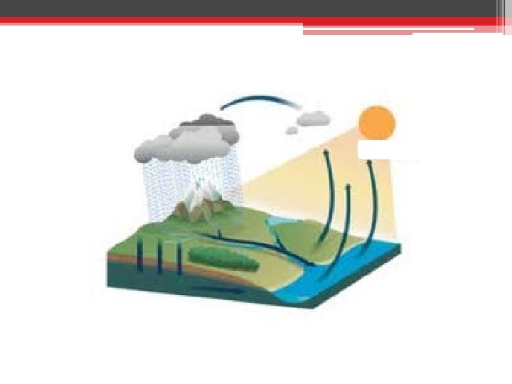
Water Cycle EPIC • Evaporation ▫ Water is warmed up enough to go from liquid to gas and rises in the air. • Precipitation ▫ Enough water molecules collect in a cloud to form a droplet as either rain, snow, sleet, hail • Infiltration ▫ The water enters into the ground. • Condensation
Air Masses that Affect the U. S. A. • • • m c T P A
Uneven heating of surfaces 6 am Land Sea 10 am 2 pm Temp (°F) Wind Speed/Dir 60. 5 68. 1 14. 1 14. 4 71. 5 69. 9 3. 2 92. 7 71. 6 20. 9 6 pm Temp (°F) Wind Speed/Dir 10 pm Temp (°F) Wind Speed/Dir 2 am Temp (°F) 79. 4 15. 8 73. 1 5. 8 66. 1 71. 7 15. 8 70. 0 5. 8 68. 9 Wind Speed/Dir 5. 3
20. 9 mph 71. 6°F 92. 7 °F
20. 9 mph
5. 3 mph 68. 9 °F 66. 1°F
Weather Maps and Fronts
This funny looking thing is a weather symbol. It represents data recorded from a weather station. The circle is cloud cover. The “tail” is the wind direction. It shows where the wind comes FROM. The feathers are the wind speed in knots. (1 knot = 1. 15 miles) What is the percent cloud cover at the station? 0% What is the wind speed in knots? 15 knots What direction is the wind coming FROM? NW What direction is it going to? SE
• 5 knots = ½ a “feather” • 10 knots = 1 full “feather” • 50 knots = triangular “feather”
• 1) Draw a weather symbol with ▫ ½ cloud cover ▫ wind at 5 knots out of the northeast.
• 2) Draw a weather symbol with ▫ 60% cloud cover ▫ wind out of the west at 55 knots.
What is a weather system? • Remember the rule of thumb. • Wind flows from areas of high to low pressure!
• Air pressure is equal to the weight of a column of air at a particular location. It is measured in millibars (mb) • High pressure systems are regions of relatively high pressure. ▫ They are associated with dry weather and clear skies. Why? - Air flows from high to low pressure. Air sinks and flows away from a high pressure system. Therefore, few or no clouds form.
• Low pressure systems areas of relatively low pressure. They are associated with clouds and precipitation. Why? Air flows from high to low pressure. Air flows toward a high pressure system and rises. Therefore, many clouds form.
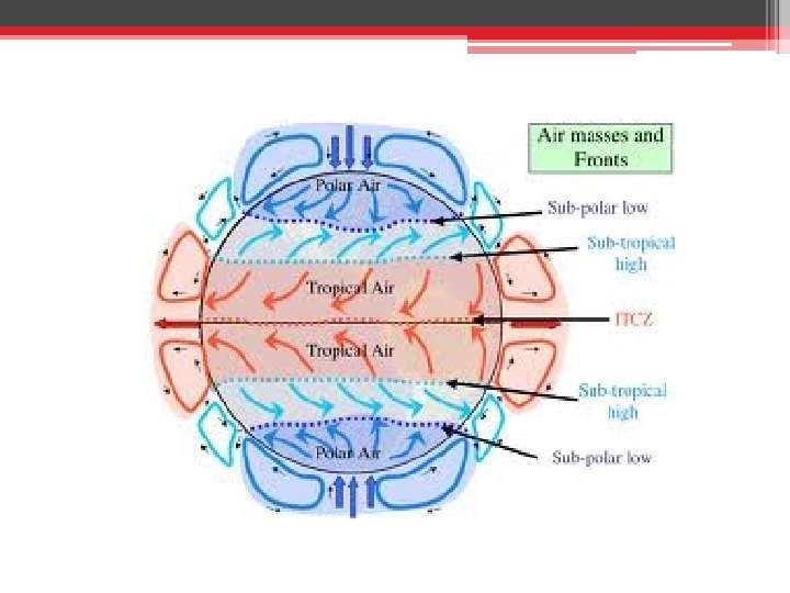
What are fronts? • An air mass is a large body of air with similar temperature, pressure, and humidity throughout. • A “front” is a boundary between air masses. • We talk about “warm fronts” and “cold fronts. ” These both happen with low pressure systems. Why can’t they occur in high pressure systems? Air flows from high to low pressure. Air sinks and flows away from a high pressure system. Therefore, few or no clouds form.
Cold Fronts ▫ A cold front is a boundary between an advancing cold air mass and a warm air mass that is already present. ▫ It is represented by triangles that point the direction the front is moving. ▫ Precipitation/clouds occur behind the front. ▫ Why?
• Cold air is more dense and “pushes” the less dense warm air up. Clouds form and precipitation occurs behind the cold front. (I. e. it gets cold before it rains).
Do cold fronts have to be “cold? ” As in freezing?
Warm Fronts A warm front is a boundary between an advancing warm air mass and a cold air mass that is already present. It is represented by semi-circles that point the direction the front is moving. Precipitation/clouds occur ahead of the front. Why?
• Warm air is less dense and rises above the cold air. It condenses and forms clouds ahead of the front.
Warm Front Cold Front Brings cold air Clouds and precipitation behind the front Occurs during a low pressure system. Brings a weather change. Brings warm air Clouds and precipitation ahead of the front
Hazardous Weather And Indiana Weather
Special Weather Events There are many types of hazardous weather • Tornadoes • Blizzards • Thunderstorms • Flooding • Hurricanes • Drought • Lake Effect Snow
Thunderstorms • The 3 Key Ingredients of a Thunderstorm ▫ MOISTURE �Large bodies of water (warmer temperatures = good) ▫ INSTABILITY �Warm moist air underneath colder dense air �As the warm air rises it will cool and form the CUMULONIMBUS clouds ▫ A LIFTING MECHANISM �Differential heating (Water vs. land), Fronts, Terrain
Thunderstorms • The 3 Stages of a Thunderstorm ▫ TOWERING STAGE �The warm air is forced upwards making the tall fluffy cumulonimbus clouds. ▫ MATURE STAGE �The air that has been raised higher cools and the precipitation begins to fall. ▫ DISSIPATION STAGE �The storm runs out of the warm moist air that fuels it.
Towering Phase
What is an Anvil?
Mature Phase • “Anvil” Shaped Top
Mature Phase • “Anvil” Shaped Top
Dissipation Stage
Types of Thunderstorms • Ordinary Cell ▫ One cycle through the previous phases • Multi-cell ▫ The storm builds and cycles through several of the phases • Squall Line ▫ The thunderstorm forms a horizontal line that spreads several miles. • Supercell ▫ Last for several hours traveling over long distances. Produce almost all of the significant tornadoes
Supercell Thunderstorm
Thunderstorm Hazards • Hail • Damaging Winds ▫ Indiana State Fair • Tornadoes • Flash-Floods ▫ Single greatest cause of death in thunderstorms
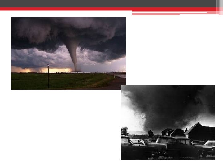
Tornado • A violently rotating column of air descending from a thunderstorm and touching the ground.
Formation • Most tornadoes are spawned from supercell thunderstorms. Supercell thunderstorms are characterized by a persistent rotating updraft and form in environments of strong vertical wind shear. • The exact processes for the formation of a funnel are not known yet.
Enhanced Fujita Scale EF scale Class EF 0 EF 1 EF 2 EF 3 EF 4 EF 5 weak strong violent Wind speed mph km/h 65 -85 105 -137 86 -110 138 -177 111 -135 178 -217 136 -165 218 -266 166 -200 267 -322 > 200 > 322 Description Gale Moderate Significant Severe Devastating Incredible
What’s more dangerous than a tornado? • The Fire Whirl
Flooding • Discuss why flooding occurs with your neighbor • Basics – Flooding occurs when there is too much water coming into an area and not enough flowing water out. • Water “Out” sources – rivers, lakes, INFILTRATION, Combined Sewer Overflows Systems. • Dangers �People underestimate how powerful moving water can be. �Even at low levels moving water is strong.
Dangers of moving Water • Of the three deaths which occurred as a result of the Fort Worth tornado, March 28, 2000, one death was due to flooding. The man who drowned was a passenger in a car with his girlfriend, the driver. They approached a low spot with water flowing over the road due to very heavy rain. Flooding was a common occurrence at this location with heavy rains and the danger was well marked. • As the driver drove her car into the water she became frightened as the water rose higher and higher around her vehicle. She backed out to higher ground. The passenger said the water was NOT too deep and he would prove it by walking across to the other side. He never made it. • Nuetzel’s Canoeing story
Lake Effect Snow • is produced during cooler atmospheric conditions when COLD winds move across long expanses of WARMER LAKE WATER, providing energy and picking up water vapor which freezes and is deposited on the opposite shores.
Lake Effect Snow
Currents and Climates
How does energy get to Earth? • The sun’s energy transfers to the earth through space through the process of radiation.
How does the heat from earth get to the rest of the atmosphere and through the oceans? • Convection currents carry the heat. • Hot, less dense fluids rise. • Cold, more dense fluids sink.
What are some global wind and water currents? • A current is a body of water or air moving in a definite direction.
Do currents go in straight lines?
• Video: Coriolis Effect • http: //www. youtub e. com/watch? v=_36 Mi. CUS 1 ro
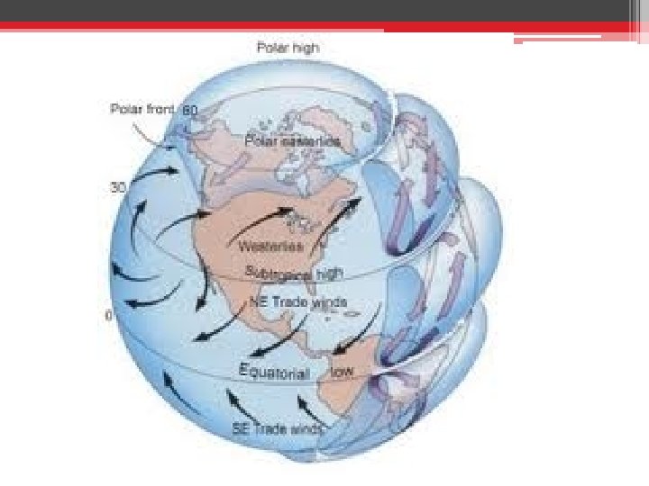
Global Winds • Winds flow from high pressure to low pressure areas. (They want to go where there are less particles). • The equator has low pressure, because warm air rises. • Winds generally flow toward the equator.
Global Winds • Air movement towards the equator is called trade winds. Why do you think they are called that?
Global Winds • Winds that blows across the US from the west are called the “Westerlies. ” • What do the Westerlies cause in the US?
Deep ocean currents • The general pattern is called the “global conveyer belt. ” • Warm water rises at the equator and travels toward the poles. • Water cools and sinks at the poles. It travels back toward the equator.
Surface Ocean Currents • Are driven by the wind blowing over the ocean’s surface. • The winds create gyres, circular patterns of currents.
• Climate is the average weather conditions over time including wind, temperature, rainfall, etc. • How is that different from weather?
Current and Climate Rule of thumb for climate: It is based on the latitude of the place. Closer to the equator is warm. But wait…. Can all climates be explained by latitude alone?
Based on latitude alone, we should expect England to have a climate similar to _________?
Why is it so warm in northern Europe compared to other places at the same latitude? • The gulf stream brings warmer water to northern Europe than would be expected for that latitude. • The difference is about 5°C warmer.
Based on latitude alone, we should expect Hawaii to have a climate similar to _________?
Why is relatively cool in Hawaii compared to other places at the same latitude?
Meteorology Match Maker • I love to travel! In particular, I enjoy the southeastern coast of the United States, the Atlantic Ocean, and the coasts of Northern Europe. I like to think I have a warm personality. ▫ Gulf Stream • My life moves at a quick pace, with a jet-set sort of lifestyle. I go wherever the wind blows me. I sometimes find it difficult to stay grounded. I am hoping to settle down with a pilot. ▫ Jet Stream • I would describe myself as worldly, really a force of nature. I feel my emotions “deeply. ” I can also be pretty hot and cold, but people get used to that. I am an avid swimmer, and I feel at home in the sea. ▫ Global Conveyor Belt • I tend to get tired easily. I often like to have a good cry, particularly after violent, sad, or loud movies. ▫ Dissipating Stage
• I have a bright and sunny personality. I like to push the blues away. My happiness and cheer spreads to everyone for miles around me. Other people feel like they are under pressure to be as happy as me! ▫ High Pressure • I am by no means straight-laced. Sometimes, I can go round and round in a conversation. I think of life as a merry-goround. ▫ Coriolis Effect • I am tall and imposing. When people see me, they know there will be trouble. People say my head is in the clouds. ▫ Anvil cloud / Cumulonimbus • I love to travel. I get cold easily, so I like to take vacations near the equator. I love to buy souvenirs on my vacations that are imported from around the world. ▫ Trade Winds
• I can tend to come on a bit strong, and I get upset by people who under-estimate me. However, people who know me understand that I am nearly overflowing with love and emotions! ▫ Flash Flood • I have a history of violent and destructive behavior. Some would even say that I am on a downward spiral, and that I am pretty twisted. Any potential mate will need to take my last name, Fujima. ▫ Tornado • I am very protective of those I am close to. You should know that I have very fair skin, and I wear SPF 75 at all times. ▫ Ozone Layer • I am a homebody, but I am still very social. Some people think I am a low-class person, that I will never live the high-life. However, I feel happy and grounded. ▫ Troposphere
Atmosphere Vocab and Concepts • Atmosphere ▫ How does the temperature change in the layers? ▫ % of Elements ▫ Troposphere ▫ Stratosphere ▫ Mesosphere ▫ Thermosphere ▫ Exosphere • Air Pressure ▫ What happens to Air Pressure in the atmosphere? ▫ High / Low • Density ▫ How does heat affect density? • Convection • Radiation • Electromagnetic Waves ▫ Which are allowed in, which are blocked? • Greenhouse Effect • Water Cycle – E, P, I, C
Atmosphere Vocab and Concepts • Unequal Heating ▫ Equator/Poles – N/S ▫ Spinning Earth- E/W ▫ Terrain – Local/Coastal • Air Masses ▫ Tropical, Polar, Arctic ▫ Maritime, Continental • Weather Map Symbols ▫ Cloud Cover/Wind Speed • High / Low Pressures ▫ Weather / Fronts / Clouds • Ocean Currents ▫ Surface/Deepwater • Climate ▫ How does convection play • Hazardous Weather • Coastal Winds out on a coastal area regarding temp/wind? ▫ Thunderstorms, Winds, Tornadoes, Hurricanes