ATMOSPHERE OBJECTIVE 2 WHAT IS THE PATTERN OF

ATMOSPHERE OBJECTIVE 2 WHAT IS THE PATTERN OF AIR MOVEMENT IN THE TROPOSPHERE AND HOW DOES IT INFLUENCE REGIONAL CLIMATES AND LOCAL WEATHER? WHAT METHODS ARE EMPLOYED TO FORECAST WEATHER PATTERNS.

Troposphere’s Pattern of Air Movement & Its Influence on Regional Climates & Local Weather Difference between climate & weather Factors that influence weather Global insolation High & low pressure Global & local wind systems Effect of land, relief & ocean currents Formation & characteristics of anticyclones, temperate frontal depressions, and tropical cyclones • Weather forecasting • •

Insolation is a measure of solar radiation energy received on a given surface area and recorded during a given time.
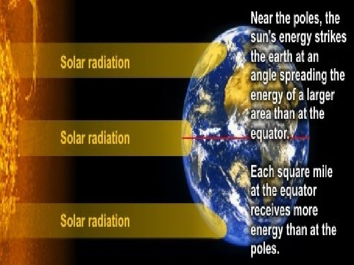

Latitude http: //wps. prenhall. com/esm_lutgens_atmosphere_10 /48/12402/3174913. cw/index. html

REGIONS OF HIGH AND LOW PRESSURE

Difference Between Climate & Weather is… Climate is…

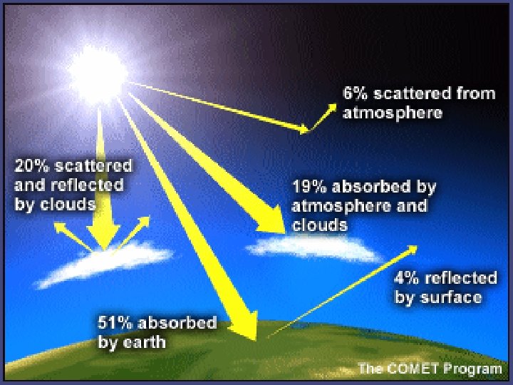
Factors That Influence Weather • Atmosphere: greenhouse effect, latent heat due to water phase changes, water cycle, winds, air mass collisions • Latitude: Direct rays vs. oblique rays, snow creates albedo area • Topography: – Uneven surface ultimately causes winds – rain falls on mountain sides closer to oceans • Water’s heat carrying capacity: range of temperature different for coastal vs. inland at same latitude, • Human Influence: ∆ in topography → less trees → less oxygen, water & more CO 2; Burning fuels → adds green house gases to atmosphere, puts particulates in atmosphere

Interrelation Between Water Cycle & the Atmosphere • Cloud condensation nuclei – Natural: Dust storms, volcanic eruptions, pollen, sea salt, respiration, combustion particles (fire) – Anthropogenic: combustion particles • Clouds (water vapor) absorb infrared radiation • Thick clouds reflect solar radiation (albedo) • Evaporation cools surfaces (latent heat of vaporization) heat is absorbed by water molecules • Latent heat of condensation

Cloud & Precipitation Formation Dew point Adiabatic temperature changes – expands – cools; compresses - warms ? y Wh
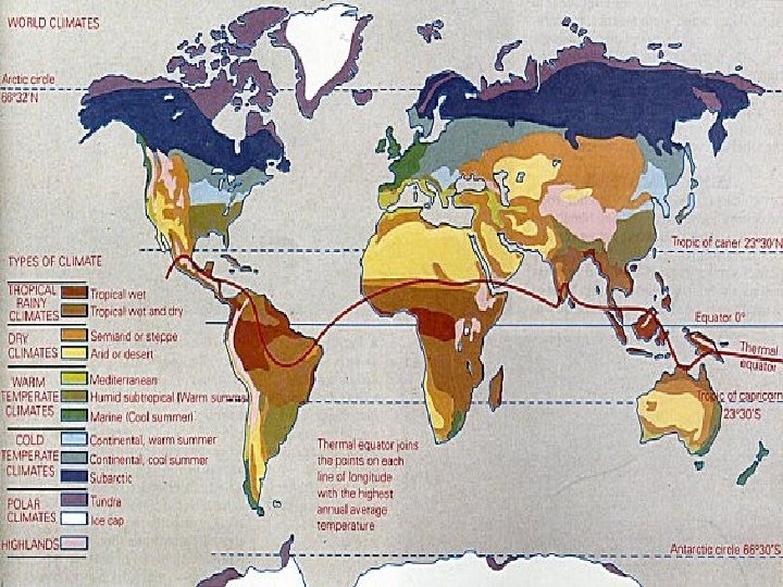

deserts

Warm temperate climate

Sub-arctics

A frontal depression is a low pressure centre with two frontal surfaces, a cold frontal surface to the left and a warm frontal surface to the right (in the northern hemisphere). Between the two frontal surfaces lies the warm sector, which is an air flow of tropical air masses. To the left and right of the frontal surfaces there is an air flow of cold polar air masses.

Four lifting processes Windward side Leeward side

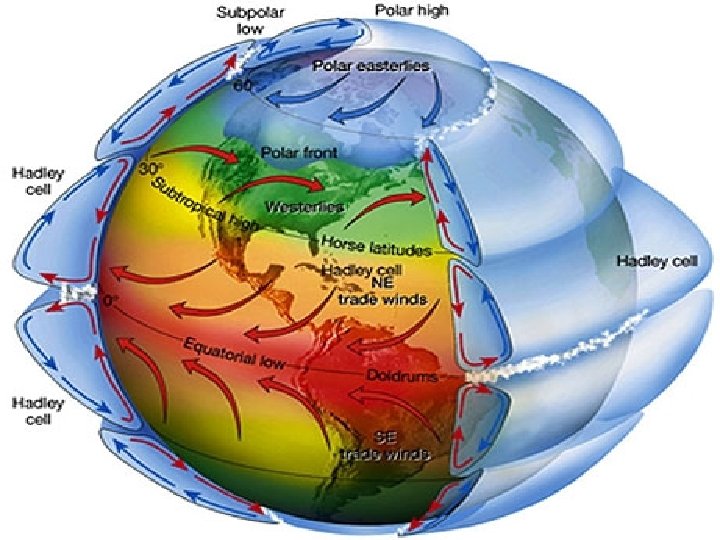
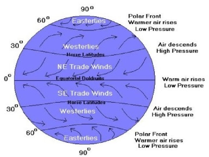
Global & Local Wind Systems • Wind – caused by differences in horizontal air pressure (High to low) • Uneven heating of earth’s surface creates pressure differences – Solar energy basis of wind energy • Wind controlled by – Pressure-gradient force – Coriolis force – Friction
 is a weather phenomenon defined by")
An anticyclone (that is, opposite to a cyclone) is a weather phenomenon defined by the United States' National Weather Service's glossary as "[a] large-scale circulation of winds around a central region of high atmospheric pressure, clockwise in the Northern Hemisphere, counterclockwise in the Southern Hemisphere"

tropical cyclone is a rapidly-rotating storm system characterized by a low-pressure center, strong winds, and a spiral arrangement of thunderstorms that produce heavy rain. Tropical cyclones typically form over large bodies of relatively warm water. They derive their energy from the evaporation of water from the ocean surface Depending on its location and strength, a tropical cyclone is referred to by names such as hurricane or typhoon, tropical storm, cyclonic storm, tropical depression, and simply cyclone.

2. Describe the usefulness of the data in forecasting future tropical cyclones. Outline two additional sources of information that could be used to make accurate tropical cyclone forecasts.
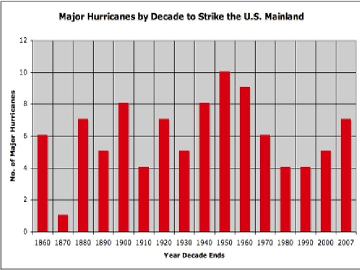

historical data. radar tracking / satellite imagery ocean temperature Climatic conditions data air pressure monitoring weather forecasting linking size to likely destructiveness sending monitoring equipment into the storm

A stationary front is characterized by no movement of the transition zone between two air masses. A cold front is cold air displacing warm air. A warm front is warm air displacing cool air diagram. Shallow leading edge warm air must "overrun" cold air--cold air recedes moves slow 10 -15 knts There are two kinds of occluded fronts: 1. Cold occlusion-cold front catches up with warm front. 2. Warm occlusion mostly in NW. Warm or cool air off the ocean
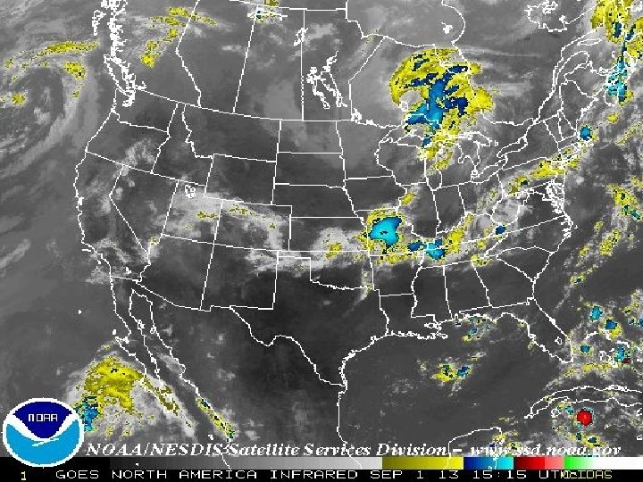
 INTERPRET THE WEATHER MAP")
AICE QUESTION: 1) INTERPRET THE WEATHER MAP

1. Maritime versus continental climate. 2. Different thermal properties of land / sea (sea has a higher specific heat capacity). 3. Insolation penetrates deep below water surface, shallow depth on land. 4. Mixing of ocean waters moderates winter temperatures. 5. Presence of warm current in North Atlantic / gulf stream. 6. The role of different air masses. 7. Cloud cover ocean a moderating influence on winter temperatures.
 against a surface due")
High & Low Pressure • Air pressure – force (Newtons) against a surface due to constant collision of gas molecules. 1 millibar = 1000 N. • Horizontal air pressure compensated to be sea level due to altitudinal differences • Cold air is ______ dense→ ____ pressure: Called _____ • Warm air is ______ dense→ ____ pressure: Called ____ • Water vapor actually reduces density.

Pressure-gradient force • Isobars • Closely spaced – strong pressure gradient with high wind speeds • High speeds generally around Lows
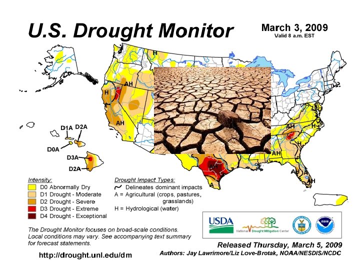

Homework! 3. STUDENTS WILL DOWNLOAD A RELEVANT CASE STUDY OF A HURRICANE(i. e. KATRINA, http: SANDY, ANDREW) AND A DROUGHT( i. e. TEXAS, INDIA, GEORGIA, CALIFORNIA) EACH STUDENT SHOULD BE ABLE TO WRITE ABOUT A CASE STUDY TO FULFILL AICE CURRICULUM.

Coriolis Effect on Horizontal Direction Coriolis effect: deflection in northern hemisphere is to _______; southern hemisphere is to _____ Degree of deflection due to Coriolis forces are stronger at higher latitudes and stronger winds.

The Different Forces That Effect Winds • Aloft air = Less friction • Wind speeds increase until Coriolis force = pressuregradient force (geostrophic balance) • Ultimately, winds travel parallel to isobars (geostrophic wind) • Steep pressure gradient = strong winds • IDEALIZED situation P-G force causes winds to move perpendicular to isobars

Link

Isobars & wind speeds Can you figure out / remember the relationship between isobars & wind speed?

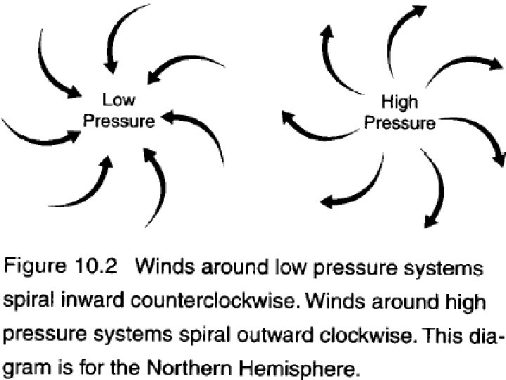
• Circular isobars means winds follow circular path to be parallel to isobars • Notice direction of L and H pressure system in Northern Hemisphere Recall Device time: Cyclone – Low Pressure center, winds travel to left (same as Earth’s rotation CCW), isobar trough

Friction’s Effect • P-G force causes wind to move. . . • Coriolis force balances wind to move. . . • Frictional force causes wind to move. . .

Notice the direction of wind of the two pressure systems.

Isobars with Fronts 1. Which direction is the wind blowing? 2. Why is the cold front “chasing” the warm front? 3. Is this hurricane status? How do you know? 4. What kind of weather is the DC area experiencing? 5. What kind of weather is TN experiencing?

Vertical Airflow for Cyclones & Anticyclones • Low pressure wind pattern at the surface • Causes net upward motion of ~ 1 km/day. Thunderstorm updrafts >100 km / hr • causes cloud formation Low pressure center pushes air up, like converging tectonic plates with similar density.

• Isobars are parallel – same pressure, same temperature • Land warms faster than water, so the continental air is warming, and therefore rising. As the air rises, it expands & cools adiabatically, thus creating the high over the land. (Creates divergence aloft) • Convergence occurs aloft over the ocean – the air piles up and becomes a heavier column which is pushed to the surface of the ocean, creating a High.

LOW PRESSURE Cool, dry air HIGH PRESSURE Heat released radiates to space Condensation and precipitation Falls, is compressed, Rises, expands, cools warms Hot, wet air Warm, dry air Flows toward low pressure, picks up moisture and heat HIGH PRESSURE Moist surface warmed by sun LOW PRESSURE Fig. 7 -4, p. 143

Global Air Circulation Cold deserts Air cools and descends at lower latitudes. Westerlies Northeast trades Forests Southeast trades 30°N Hot deserts Warm air rises and moves toward the poles. Air cools and descends at lower latitudes. 60°N Equator 0° Hot deserts Westerlies Forests Cold deserts 60°S 30°S Solar energy The highest solar energy input is at the equator. Fig. 7 -3, p. 142

Climate patterns and moisture distribution
:")
Storms pose hazards • Atmospheric conditions can produce dangerous storms • Hurricanes (typhoons, cyclones): form when winds rush into areas of low pressure – Warm, moist air over the topical oceans rises – Drawing up huge amounts of water vapor – Which falls as heavy rains • Tornadoes: form when warm air meets cold air – Quickly rising warm air forms a powerful convective current (spinning funnel)

We need to understand the atmosphere • Understanding how the atmosphere works helps us to: – Predict violent storms and protect people – Comprehend how pollution affects climate, ecosystems, economies, and human health
- Slides: 53