Atmosphere Higher Geography Physical Environments Introduction Skin cancers


")
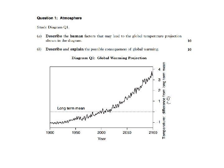
 From Paper 1 2007: Study reference diagrams Q 1 A")

: Homework Describe and explain the varying rainfall patterns shown in")


- Slides: 91
Atmosphere Higher Geography: Physical Environments
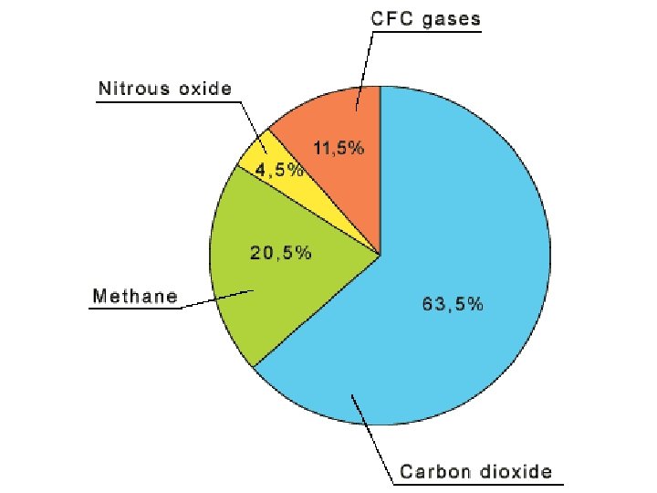
Introduction Skin cancers Global warming Atmosphere in the news Hole in the ozone layer Climate change Acid rain Greenhouse gases CFC’s Although considered a difficult topic, this is the most up-to-date of the basic units!
What we will learn Atmosphere for Higher Geography is being able to say how energy is moved around the world: – in the air (air circulation) – and the sea (ocean circulation)
What is the atmosphere? The atmosphere is the gases that surround our planet. They are held in place by gravity. Atmosphere is made up of several gases. Without it there would be no life on Earth!
Structure of our Atmosphere The atmosphere is divided into four main layers, each with a characteristic mixture of gases and a range of temperatures. You will need to know the order these layers come in and their names. Note that between each layer is a junction called a ‘pause’.
Layers of the Atmosphere
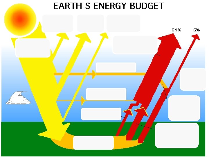
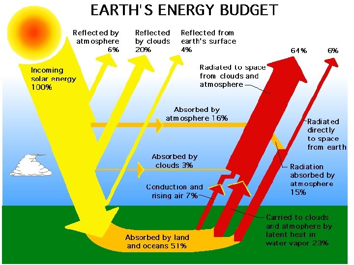
Global Heat Budget The amount of energy the Earth gets from the sun and how it is used / absorbed or reflected. Insolation = Energy coming into our atmosphere (input) Radiation = Energy coming out of the atmosphere (output)
Activity Global heat budget bingo! You have 5 minutes to read your statement cards and number them according to where you think they go on the blank global heat budget. We will then see who got it right!
2 3 4 12 1 8 11 7 10 6 9 5
This would only apply in a perfect world…but we have an imbalance. Why do the poles get less energy? Why does the equator get more energy?
Latitude
Thickness of Atmosphere
Extra Notes… In Polar regions, there is a greater amount of atmosphere to pass through, so more risk of it being deflected away. Because of the angle of the rays, there is more Polar land to share the heat than at the Tropics, so it averages cooler temperatures. Light coloured surfaces- like snow- reflect heat back into the atmosphere. Forests- like rainforests- are dark and absorb heat. Throughout the year, Polar areas get less time in the Sun than do Tropical areas due to the tilt of the Earth and the orbit around the Sun.
Starter On your show me boards, answer the following questions: 1. What is the name given to energy entering the Earth from the Sun. 2. Draw a diagram to show the 4 pauses of the atmosphere. 3. What percentage of solar insolation is reflected by the atmosphere? 4. Give two reasons why it gets colder as you move further from the equator.
Aims of the lesson • To learn about the formation of the 3 cells that exist in our atmosphere. • To learn about the pressure belts associated with each cell. • To learn about the wind patterns associated with these cells.
Formation of the Hadley Cell Insolation in tropical areas causes warm air to rise and spread polewards, carrying heat energy. INSOLATION SOLAR ENERY 19
Air cools and begins to fall at about 30ºN and 30ºS of Equator. Cooled air returns to the Equator. NORTHERN HADLEY CELL. SOLAR ENERGY Heat energy is therefore transferred from the Equator to sub-tropical latitudes. SOUTHERN HADLEY CELL.
Formation of the Polar Cell Intensely cold, dense air sinks at the poles, then blows as surface winds towards the Equator. 21
At about 60ºN and 60 ºS, the cold polar air is warmed in contact with the earth’s surface. NORTHERN POLAR CELLS. This warmed air rises and returns polewards, carrying heat energy. This circular motion is called the POLAR CELL. SOUTHERN POLAR CELLS.
Formation of the Ferrel Cell Unlike the Hadley and Polar Cells, the Ferrel Cell is not driven by differences in heat energy. The Ferrel Cell is caused by friction where air is in contact with the other two cells. (The Hadley Cell drags air down at about 30ºN and S. The Polar Cell causes an uplift at about 60ºN and S. ) 23
THE THREE CELLS TOGETHER Polar Cell Ferrel Cell Hadley Cell Ferrel Cell Polar Cell 24
Cells It is well worth making sure that you can see the rising and falling pattern of these cells. The next section uses this to work out wind directions on the surface of the earth.
ASSOCIATED PRESSURE BELTS Rising air at the equator causes the equatorial belt of low pressure Descending air at about 30ºN and 30ºS causes the subtropical belt of high pressure Polar high pressure Mid latitude low pressure Sub-tropical high pressure Equatorial low pressure Rising air at about 60ºN and 60ºS causes a mid-latitude belt of low pressure Sub-tropical high pressure Mid latitude low pressure Descending air at the poles causes the polar high pressure areas Polar high pressure 26
ASSOCIATED SURFACE WIND PATTERNS Winds always blow from high pressure to low pressure. They are deflected because of the Coriolis Force which come about because of the rotation of the earth. Winds in Northern Hemisphere are deflected to the right. Winds in the southern hemisphere are deflected to the left. These wind belts shift seasonally. (See next section) Polar high pressure Mid latitude low pressure Sub-tropical high pressure Equatorial low pressure Sub-tropical high pressure Mid latitude low pressure Polar high pressure
Explain how circulation cells in the atmosphere and the associated surface winds assist in the transfer of energy between areas of surplus and deficit. 8 Marks This question is asking you to explain: - How cold air is transferred southwards towards the equator - How warm air is transferred northwards towards the poles - The winds that are created because of the moving air. - You should be mentioning: - Deficit at poles - Surplus at equator - Creating a balance
• The Equator is an area of surplus energy, the poles are an area of deficit. • The Hadley cells form above the equator. • Warm air transfers the energy upwards into the atmosphere. It then moves northwards and southwards toward 30 degrees North and south of the equator. • The warm air cools and begins to drop at 30 N and 30 S, transferring warmer air northwards and southwards. • The cool air then travels back towards the equator. This creates the trade winds which assist in energy transfer.
• Above the poles we find the polar cells. Cold air is pushed downwards towards the earth and travels down towards 60 N and S of the equator. • This movement creates the Easterlies winds which transfers cooler air to warmer latitudes. • As it travels over the land it warms and then begins to rise at 60 N and S allowing for warm air to be redirected back to the poles. • The Ferrel cells form between the Hadley and Polar cells and energy moves because of friction created. • These movements allow for warm air to redistribute the surplus energy from the equator to the poles.
This question is asking you about the reasons why there is an imbalance in the global heat budget. You should mention: • Impact of latitude • Thickness of the atmosphere • Distance from the sun • Albedo effect. Include diagrams!
Marking Scheme
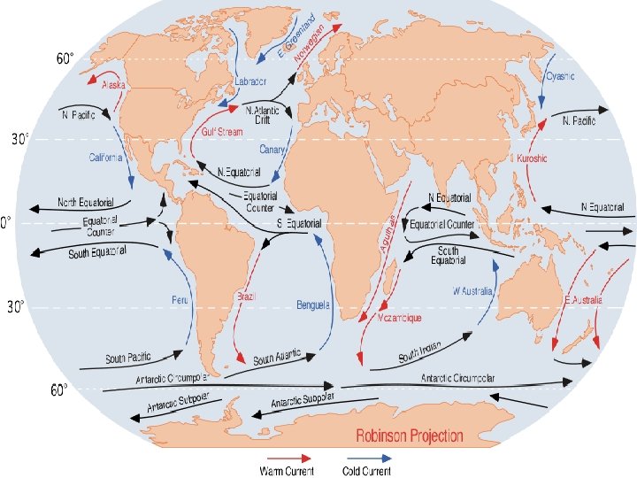
Describe the pattern of ocean currents in the North Atlantic Ocean, and explain how they help maintain the global energy balance. 6 Marks Answer could include: • Where cold currents travel from + named example • Where warm currents travel from + named example • How land masses deflect currents • What is happening to the surplus energy and deficit energy at equator/poles • How salt content effects currents • How winds / friction affect the direction of currents • The coriolis effect
• There is an energy surplus at the equator and a deficit at the poles. • There are warm currents directed northwards fro the equator known as the gulf stream and north Atlantic current. • There are cold currents directed southwards from the poles one is called the east Greenland current. • Often ocean currents are deflected by land masses and circular shaped loops of water form called gyres. • This means that surplus energy often does not reach the poles. • In the N Atlantic ocean currents travel in a clockwise direction because of the coriolis force. • They also move in the direction of the prevailing winds due to friction.
Mark Scheme • Description and Explanation might include: currents follow loops or gyres – clockwise in the North Atlantic. In the Northern Hemisphere the clockwise loop or gyre is formed with warm water from the Gulf of Mexico (Gulf Stream/North Atlantic Drift) travelling northwards and colder water moving southwards eg the Canaries Current. currents from the Poles to the Equator are cold currents whilst those from the Equator to the Poles are warm currents. Cold water moves southwards from Polar latitudes – the Labrador Current. This movement of warm and cold water thus helps to maintain the energy balance. ocean currents are greatly influenced by the prevailing winds, with energy being transferred by friction to the ocean currents and then affected by the Coriolis effect, and the configuration of land masses which deflect the ocean currents. Due to differential heating, density differences occur in water masses, resulting in chilled polar water sinking, spreading towards the Equator and displacing upwards the less dense warmer water
Aims of the Lesson: • Revise air masses • Look at how the boundary of two conflicting air masses effect the climate in Africa. • Understand this conflict as the ITCZ (Inter Tropical Convergence Zone)
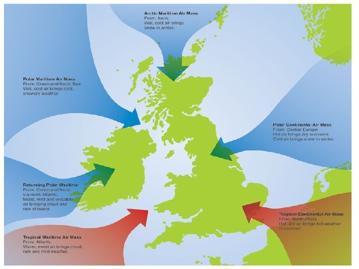
Air Masses An air mass is a large volume of air with uniform characteristics of temperature and humidity, acquired from its source region (where it comes from). The characteristics of the air mass are determined by the climate of the place where it originated. • Air masses which form over oceans are termed “MARITIME”. These will bring wet weather. • Air masses which form over land are called “CONTINENTAL” These will bring dry weather. • Air masses are also called POLAR, TROPICAL or ARCTIC depending on where they formed.
Air masses in Africa and the ITCZ • The main air masses influencing the climate of Africa are Tropical Continental and Tropical Maritime. • Their meeting place (where they converge) is known as the Inter Tropical Convergence Zone (ITCZ).
Tropical Continental c. T AFRICA ITCZ A warm, dry air mass given its origin over the tropical Sahara Desert. Brings warm, dry stable air. Extremely warm temperatures. No rainfall or cloud. Also brings a warm, dry Harmattan wind. Weather conditions are monotonous. Where the air masses converge Tropical Maritime m. T A warm, wet air mass given its origin over tropical oceans (the Atlantic). Brings moist, unstable air causing rainfall and thunderstorms. Temperatures can be hot and weather patterns vary.
Sahara Desert Sahel, semi desert South of Africa, Rainforest over equator, grasslands as you go south.
How does the ITCZ and its associated air masses influence the climate of Africa? The ITCZ shifts position throughout the year in relation to the apparent movement of the sun because of the way the earth sits on its axis. In July The sun is directly overhead the Tropic of Cancer due to the tilt of the earth. The ITCZ migrates northwards and is positioned over the Tropic of Cancer. Tr op ic E qu of Tr op at Ca ic or nc of er Ca pr ico rn ITCZ is positioned at the Tropic of Cancer ITCZ 23 ½ºN 0º 23½ºS
This means that Africa is dominated by the Tropical Maritime air mass, bringing with it warm, wet and generally unstable conditions. This explains why July is Africa’s wet season. c. T ITCZ m. T ITCZ positioned at Tropic of Cancer Warm moist unstable Tropical Maritime Air dominates most of Africa.
In January The sun is directly overhead the Tropic of Capricorn due to the tilt of the earth. Therefore the ITCZ migrates south and is positioned over the Tropic of Capricorn. r nce orn a c of Ctor apri c i p a C Tro Equ ic of p Tro ITCZ 23 ½ºN 0º 23½ºS ITCZ is positioned at the Tropic of Capricorn
This means that much of Africa is influenced by Tropical Continental air, bringing with it warm, dry stable conditions and the warm, drying Harmattan wind. This explains why most of Africa experiences its dry season at this time of year. ITCZ m. T c. T Warm, dry stable Tropical Continental Air dominates most of Africa. ITCZ positioned at Tropic of Capricorn
• Some western and southern parts of Africa remain under the influence of Tropical Maritime air because the Tropical Continental air mass (above the ITCZ) is not strong enough to push against the Tropical Maritime air mass which is moving into the land from the sea. • In March and September the sun sits directly overhead the Equator, so at these times of year the ITCZ is positioned over the Equator.
Problems with the ITCZ in recent years In recent years the ITCZ has not migrated as far north as it should do in July. It has only shifted position to 14ºN of the Equator. This means that the Tropical Maritime (warm, wet) air does not reach the Sahel region of Africa. Instead, this part of Africa is dominated by Tropical Continental air, resulting in hot dry conditions and a summer drought. In Winter (January) the ITCZ migrates to its position at the Tropic of Capricorn so the Sahel region remains dominated by the warm, dry Tropical Continental Air. This means that for most of the year the Sahel region of Africa is influenced by extreme heat and dry conditions, causing drought, soil erosion, desertification and land degradation.
Task Time! Use your notes on the ITCZ to answer the following questions: 1) 2) 3) 4) 5) 6) 7) 8) 9) Write a definition for the ITCZ. Why does the ITCZ appear to migrate to different positions throughout the year? Where is the ITCZ positioned in a) July b) January c) September? Explain why most of Africa experiences warm, wet weather in July. Explain why most of Africa experiences its dry season in January. Why do some parts of western and southern Africa always experience Tropical Maritime air? What has happened to the movement of the ITCZ in recent years? Describe the consequences of this movement on the Sahel region of Africa. Have a go at ACTIVITY 6 on page 7 of the Higher Geography textbook
Example exam question (1) From Paper 1 2007: Study reference diagrams Q 1 A and Q 1 B. Identify air masses A and B, and describe their origin and nature. (6)
How to answer Air mass A is Tropical Continental or c. T. It originates over the Sahara Desert in tropical latitudes, hence its name, tropical continental. It brings warm, dry stable air and extremely warm temperatures to the areas over which it passes. There is a lack of rainfall or cloud. Air mass B is Tropical Maritime or Mt. It originates over the Atlantic ocean in tropical latitudes. It brings warm, moist unstable air, causing rainfall and thunderstorms.
Example exam question (2): Homework Describe and explain the varying rainfall patterns shown in reference diagram Q 1 B. (12)
How to answer Timbuktu has on average very little rainfall (only 250 mm per annum). It has no rainfall at all in January, February November and December. Jos too has distinct wet and dry seasons, experiencing 1000 mm of rainfall per annum, a peak of 300 mm in July and minimal rainfall in November, December, January and February. In contrast, Lagos has markedly more rainfall throughout the year, with up to 2000 mm per annum, and rainfall peaking twice in the year. (June at 475 mm and October at 200 mm). It also has no dry months at all. These patterns can be attributed to the movement of the ITCZ and its associated air masses. Lagos is under the influence of warm moist Tropical Maritime air for most of the year, which explains its higher annual rainfall amounts and lack of dry season. Its twin rainfall peaks are caused by the ITCZ migrating northwards and southwards in relation to the position of the sun. Timbuktu and Jos in contrast are much further North than the ITCZ in January, which is positioned at the Tropic of Capricorn. This will result in Timbuktu and Jos being influenced by warm, dry Tropical Continental air, which explains why they have either No or very little rainfall during these months.
In June and July Timbuktu and experiences its highest rainfall amounts because the ITCZ has migrated northwards due to the position of the sun overhead the Tropic of Cancer. This results in Timbuktu experiencing Tropical Maritime air at these times, hence its this is when it gets the majority of rainfall. Similarly, this is why Jos experiences its highest rainfall totals (300 mm and 275 mm respectively) in July and August. NOW YOU HAVE A GO – REMEMBER DON’T PANIC, THIS IS DIFFICULT!!! 1) 2) 3) Collect a copy of the TWO past paper questions. Read each question carefully, then write a detailed answer to each. Get your answers checked by your teacher.
Summary So far we have… • Learnt the definition of an air mass. • Learnt how to describe the characteristics of air masses. • Learnt the definition of the ITCZ and the influence of it on the winter and summer weather conditions of Africa.
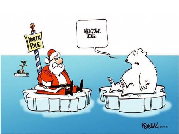
Aims of the lesson • To learn about the human and physical factors that may be causing global climate change. • To discuss the possible consequences of climate change.
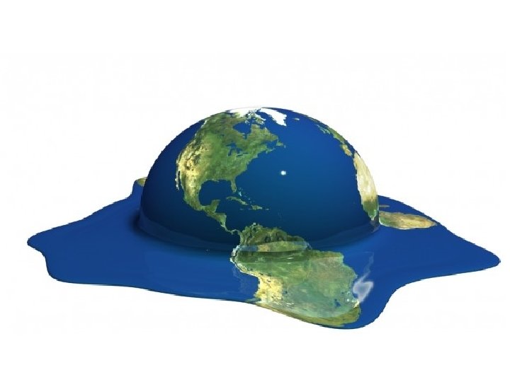
Climate Change Climate change is a significant and lasting change in the statistical distribution of weather patterns over periods ranging from decades to millions of years.
The Greenhouse Effect The Sun The Earth
Mauna Loa Climate Graph
Temperature Variation over 800, 000 Years
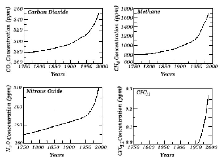
Physical & Human Factors As we can see from the two graphs on the previous slides global climate has always varied naturally. However, we are now 95% certain that current climate change is being driven mainly by human activity.
Physical & Human Factors Physical: • Solar variation • Volcanic activity • Ocean currents • Milankovitch cycles Human: • Burning fossil fuels • Increased output of methane etc. • Deforestation
Information Treasure Hunt Working in pairs, you are going to collect information on each of these factors affecting climate change. Resources available: • Library Computers (1 between 2) • Library Reference Books • B 10 Reference Books
PHYSICAL 1 - SOLAR VARIATION • Sunspots: an increase in sunspot activity may lead to a very slight increase in the sun’s output and a temporary warming of the earth. • Sunspot activity follows 11 and 22 year cycles. • The Little Ice Age of 1450 -1700 may have been linked to periods of very low sunspot activity.
PHYSICAL 2 - VOLCANIC ERUPTIONS • Eruptions of volcanoes can throw millions of tonnes of ash, dust and sulphur dioxide into the atmosphere. • This produces aerosols that can reduce the amount of sunlight reaching the earth. • This can lead to a temporary cooling of the earth.
VOLCANIC ERUPTIONS 2 • Major eruptions in the past which have been linked to short periods of global cooling include Mt. St Helens (1980)
When Mt. Pinatubo erupted in 1991 an estimated 22 million tons of ash was thrown into the atmosphere, cooling the world’s climate by about 1°C. When Tambora erupted 1815 it led to 1816 being called “the year without summer”, when summer frosts and other major weather problems were experienced. It cooled th global climate by 3°C.
PHYSICAL 3 - MILANKOVITCH CYCLES • Stretch, Wobble and Roll!!!
• Milankovitch cycles are three variations in the earth’s orbit. Although they may be linked to very long term changes in the climate, their effect would not be noticed on a scale of a few hundred years.
PHYSICAL 4 - OCEAN CURRENTS • Changes in the pattern and strength of ocean currents may lead to changes in the distribution of heat around the planet. • A short term example would be El Niño, which appears every few years. • A longer term example would be the North Atlantic Drift, which may change position every few thousand years.
ENSO - the El Niño Southern Oscillation The “normal” conditions, with cool surface water off the coast of Peru. A La Niña year Every 2 -7 years the western Pacific becomes much warmer, disrupting weather patterns possibly on a global scale. An El Niño year
- HUMAN FACTORS -
HUMAN 1 - BURNING FOSSIL FUELS • The fossil fuels are: • COAL • OIL • NATURAL GAS • They are called fossil fuels because they are formed from the remains of ancient plants (coal) and marine animals (oil).
BURNING FOSSIL FUELS When we burn these fuels, we release millions of tonnes of Carbon Dioxide (CO 2) into the atmosphere. There has been an enormous increase in these greenhouse gases since the Industrial Revolution began about 200 years ago.
BURNING FOSSIL FUELS Power stations are one of the main producers of greenhouse gases such as Carbon Dioxide.
Environmental campaigners all over the world are demanding cuts in CO 2 emissions. Here Greenpeace uses a light display to get its message across.
HUMAN 1 - VEHICLE EXHAUSTS Vehicle exhausts are the main source of Nitrous Oxides.
HUMAN 2 - INCREASED METHANE The huge increase in world population and in the area of land given over to crops in general and to rice production in particular, has led to a rapid rise in global methane production. Farmland for rice has doubled in 45 years.
I am a ruminant - when I digest grass, I produce methane - lots of it!
HUMAN 2 - INCREASED METHANE • A cow can burp / fart about a quarter of a kg. of methane a day. • The number of cattle has doubled in the past 40 years. Sheep, goats and camels are also ruminants. • There are now 1. 3 billion cattle, each burping / farting methane several times a minute! • The New Zealand government is proposing to bring in a “flatulence” tax on cattle farms.
HUMAN 3 - DEFORESTATION Forests absorb CO 2 and release oxygen: . . . if they are cut down, atmospheric levels of CO 2 must rise as a consequence.
HUMAN 3 - DEFORESTATION • Clearing forest by burning releases huge amounts of stored CO 2 back into the atmosphere. • The smoke from the fires also adds to global air pollution.
What are the consequences? In your groups, create a spider diagram of all the possible consequences of global climate change.