ATHABASCA OIL SANDS Ryan Johnson WHERE ARE THE

ATHABASCA OIL SANDS Ryan Johnson

WHERE ARE THE ATHABASCA OIL SANDS? • Northeast Alberta, Canada

WHAT’S SO SIGNIFICANT? • 1. 8 trillion bbl of resources in northeast Alberta • 1 trillion bbl contained in Athabasca oil sands • Located at outcrop level or shallow depth • Location known from direct observation prior to Geological Survey of Canada descriptions • 1875 • Tar pits

WHAT’S THE PROBLEM? • Petroleum trap is elusive • Trap destroyed due to continued flexural loading • Uplift and erosion • Confusion as to how petroleum was held in place over such a large area

APPROACH • Use a paleohorizon to examine historical orientation of the layers during charge of oil • Well data (70, 000+ well picks) • Identify charge timing of regions of the Athabasca oil sands • Use bitumen-water contact to further confirm orientation of the region • Use kimberlite age dating to correlate with charge timing of oil sands • Was used after study was finished, but good blind test
 formation • Precambrian")
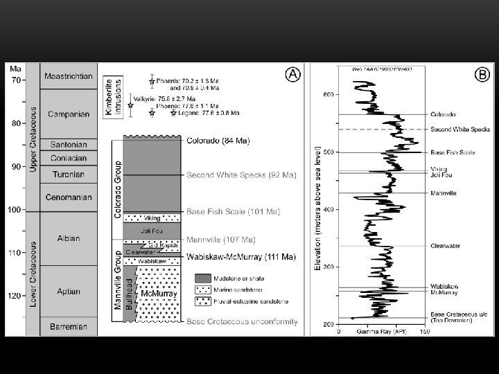
HISTORY • Western Canada Sedimentary Basin (location of Athabasca oil sands) formation • Precambrian rifting • Paleozoic thermal subsidence along passive margin (western NA) • Megasequences • Paleozoic carbonates, evaporates, and shales • Exshaw Formation (source rock) • Late Mississipian to Late Jurassic transitional meagsequence (subdued subsidence) • Siliciclastic-dominated succession • Gordondale (source rock)

HISTORY – MEGASEQUENCES CONT. • Late Jurassic shift to flexural subsidence by Rocky Mountain fold and thrust belt • Siliciclastic-dominated sequence • Mannville Group (reservoir rock) • Mc. Murray Formation (fluvial-estuarine sands) • Wabiskaw Member (marine sands) • Capped by Clearwater Formation (shale) • Marine transgression • Overlain by Colorado Group (marine sediments) at Athabasca oil sands • Continuation of flexural subsidence through early Eocene

HISTORY

PETROLEUM FORMATION • Source maturity peak at Late Cretaceous • Flexural loading led to maximum burial • Migration of oil hundreds of kilometers from west to east • Petroleum contained mostly in Mannville Group • Athabasca oil sands too shallow to pasteurize • Never exceeded 45°C • Biodegradation to bitumen • Coeval charge and biodegradation • Formation of bitumen before tilting

RECONSTRUCTION OF TRAP • Colorado Formation used for reconstruction • Formed around 84 Ma • Presence of a major four-way anticline in central Athabasca area • 285 km x 175 km • 60 m amplitude (240 -300 m depth) • Primary structural trap in Athabasca area • In addition to coeval charge and biodegradation, bitumen distribution controlled by structural and stratigraphic trap elements

TRAP DOMAINS • Athabasca area split into 6 distinct domains • Central Athabasca (structural trap) • 44% of Athabasca oil sands by area • 300 m closure • Northeastern Athabasca (onlap trap) • Shallowest trap edge (200 m or less) • 270 m lower limit • Tarry bitumen outliers • Leakage at pinch-out
 • Below 270 m • Late")
TRAP DOMAINS CONT. • Northern Athabasca (bitumen trap) • Below 270 m • Late charge of oil contained by bitumen already emplaced • Other bitumen traps • Southern & Southwestern Athabasca, and Wabasca • Below 300 m spillpoint • Also represent late charge of oil

TRAP DOMAINS

BITUMEN-WATER CONTACT • Defines contact line between bitumen and water separation due to density differences • Local variations in each trap domain • Conforms with paleostructure reconstruction • Differences in elevation back interpretations of charge order • Central filled first • Northeastern onlap trap second • Followed by deeper peripheral bitumen traps

RESTORED PALEOSTRUCTU RE

KIMBERLITE • Numerous Late Cretaceous and Paleocene kimberlite pipes • Radiometric dating have been determined • Spatial and temporal relationship to bitumen • 3 drill holes with bitumen • “Soaked” in bitumen • Petroleum charge after intrusion of kimberlites • Age dated at 78 -70 Ma • 2 at almost exactly 300 m closing contour • 1 at 334 m (northern trap domain) • Reinforces 84 Ma charge of anticline • Northern trap charged no earlier than 78 Ma

KIMBERLITE PIPE
")
CONCLUSION OF EVENTS • 1. Filling of the Central Athabasca four-way anticline (84 Ma) • Coeval charge and biodegradation led to impermeable bitumen (no gas cap) • 2. Filling of Northeastern Athabasca onlap trap • Shallowest and first to fill after spillpoint of the anticline was breached • Shallow depth also led to gas accumulation • 3. Filling of peripheral bitumen traps (No earlier than 78 Ma in north) • Updip bitumen seal • 4. Erosion from Eocene to present • Preservation of trap due to rapid rate of biodegradation to bitumen • Tarry bitumen leaks onto surface where erosion has reached the reservoir and at onlap edge

CONCLUSION OF EVENTS
- Slides: 20