Asia Unit Introduction Defining South Asia South Asia


, Gupta (4 th")


- Slides: 33
Asia Unit Introduction
Defining South Asia
South Asia
The Size of South Asia
Subcontinent • Subcontinent- large landmass that juts out from a continent • 3 of world’s 10 most populous countries- India, Pakistan, and Bangladesh
History and Religions
Introduction: On This! • Although virtually surrounded by mountains, South Asia is home to ancient cultures influenced by other parts of Asia • Harappan • Aryans • Moguls (Mongols) Good Chance A Midterm Question
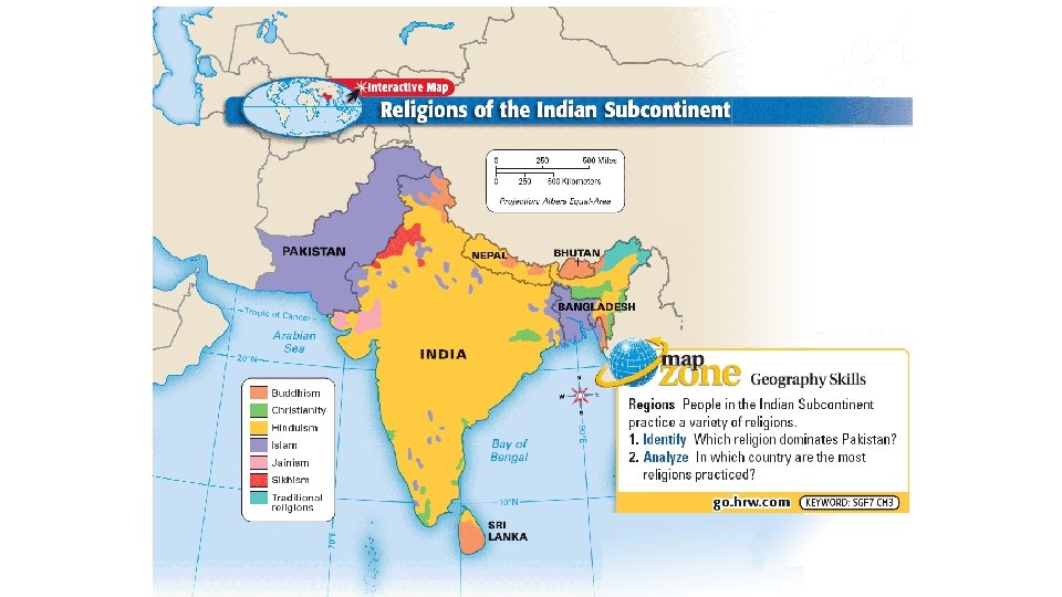
South Asian Religions • South Asia is the origin of three different religions • Hinduism • Buddhism • Sikhism • The region is also home to 3 of the 4 largest Muslim populations
Hinduism • An uniquely South Asian religion, Hinduism is one of the oldest religions in the world. • Hinduism contains many different Gods, all representing facets of the unity of the universe, or one God, Brahman
Buddhism • Buddhism formed in northeastern India in the 6 th century B. C. based on the teachings of its founder Siddhartha Gautama – The Buddha • Over the following centuries, it diffused throughout much of Asia.
Sikhism • The Sikh religion originated in the Indian region of Punjab during the late 1400 s. • About 23 million people now practice Sikhism worldwide.
Geography and Key Geographic Features
The Hindu Kush Mountains and the Himalayan Mountains have acted as a barrier to isolated the region! Good chance this is a test question on the Midterm! Key Physical Features Mountains • Hindu Kush mountains divide the subcontinent from Central Asia. • The Eastern and Western Ghats separate India’s east and west coasts from the country’s interior. • The Himalayas run along the northern border and are home to the world’s highest mountains. Rivers and Plains • The rivers flood each year, leaving fertile plains. • India’s most important river is the Ganges. • A delta is a landform at the mouth of a river. • The Ganges Plain is India’s farming heartland. • The Indus River creates a fertile plain known as the Indus River Valley. Other Features • The Deccan is a large, hilly plateau located to the south of the Ganges Plain. • The Thar, or Great Indian Desert, is made up of rolling sand dunes. • The Tarai in southern Nepal has fertile farmland tropical jungles.
Go to Page 597 • In the three inset boxes, write the additional information on the lines next to the previous slide.
Mountains – Himalaya • As the Indian subcontinent moves slowly and steadily into Asia, it pushes up the highest mountains in the world • The 1, 500 -mile (2, 414 -km) long Himalaya, which have individual peaks that reach more than 5 miles (8 km) high. • Contains the tallest mountain in the world, Mt. Everest
Mountains – Karakoram Range • The Karakoram Mountain Range extends over some 80, 000 square miles (207, 000 sq. km) • It contains Earth's secondhighest peak, K 2.
Major Rivers • Major rivers drain the region from their source high in the Himalaya in the north to the floodplains in the south. • These rivers carry fertile soil used to grow food for the region’s large population.
Go to page 598 • Write down the names of all the different mountain ranges and ghats (ghats are ranges of hills) found in South Asia on the lines next to the previous slides. • Write down the name of the main plateau found in South Asia on the lines next to the previous slides.
Ganges River • The Ganges River is one of Hinduism's most sacred sites. • Hindus believe that scattering the ashes of the deceased on the Ganges aids the soul in the next life.
Ganges River • South Asia's powerful Brahmaputra River carries rich soil throughout the region. • However, the river can also cause destructive flooding. • In 2012, some 1. 7 million people were forced from their homes because of flooding along the Brahmaputra.
Go to pages 598 -599 • Write down the names and location of each of the major rivers in South Asia on the lines next to the previous slides.
Indo- Gangetic plain Area that surrounds the Ganges and Brahmaputra rivers Best farmland in India • • No coincidence that this is one of the two most densely populated areas in India • • They farm rice, wheat, cotton, sugarcane, and tea
Indo-Gangetic Plain • Densely populated region • Centers of Maurya(300 BC), Gupta (4 th Century Ad) Mughal ( 1526 -1707) and the British Empire (1757 -1947) • Major Urban Centers in South Asia • Lahore, Delhi, Banaras, Calcutta and Dacca • Agricultural Heartland of India, Pakistan, Bangladesh.
Go to the Economic Activity Map on page 547 and the Population Density Map on page 547 • Write down on the lines next to the previous slides: • Where are the main areas of commercial and subsistence farming? • How does this relate to the rivers, plains, and population density?
Climate Regions 1. Highland climate • Himalayas • Brings cool temperatures to much of Nepal and Bhutan 2. Humid subtropical climate • Plains south of the Himalayas • Hot, humid summers with plenty of rainfall 3. Tropical climate • Covers much of the subcontinent • Tropical savanna in central India and Sri Lanka • Humid tropical climate in southwest India, Sri Lanka, Maldives, and Bangladesh 4. Desert and steppe climate • Throughout southern and western India and most of Pakistan • Dry
Go to the Climate and Vegetation Map on page 557 • Write down on the lines next to the previous slide the types of vegetation found in each climate zone.
Go to the Population Density Map on page 547 and the Climate and Vegetation Map on page 557. • Identify which cities have over 5 million people. • What areas have high population density and how does this relates to the major geographic features and climate and vegetation zones?
Monsoon – Seasonal Winds • Strong winds traveling across warm seas bring the wet season to South Asia, providing rain vitally needed by the region’s farms but also causing flooding in low-lying areas. • These same winds blow out to sea during the winter months, leading to a prolonged dry season. • Good chance this is a test question on the Midterm!
Seasonal winds known as monsoons bring rain every summer. India is dependent upon monsoons to grow their crops. Not enough rain brings drought. When there is too much rain, rivers rise and cause deadly floods and destruction of crops.
Climate Monsoons - seasonal winds that blow from the NE Nov. to Mar. and from the SW June to Oct.
Climate If the wet monsoon arrives late or brings little rain, crops fail; too much rain, flooding destroys the countryside
Go to the Colored Monsoon Map you were given • Label the areas that DO NOT RECEIVE ANY RAIN FROM THE SUMMER MONSOONS. • Then go back to the Population Density Map on page 602, and make notes on the Monsoon Map of the major cities like Mumbai, Hyderbad (India’s and Pakistan’s), etc… • At the bottom of the Monsoon Map, explain the relationship between the monsoons and the population density in BULLET FORMAT.