As hot magma rises towards the Earths surface


- Slides: 25
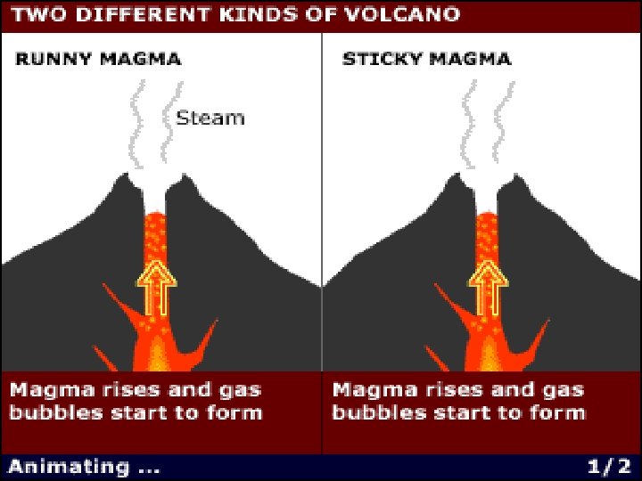
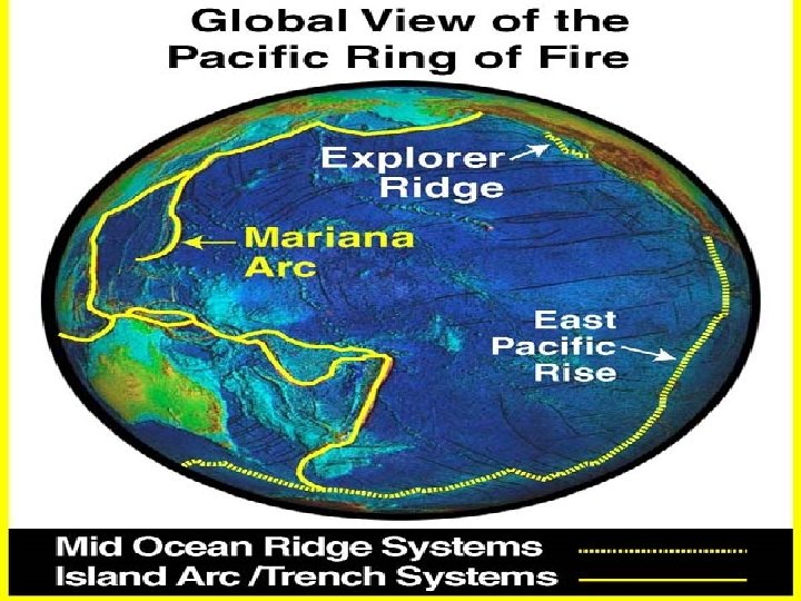
As hot magma rises towards the Earth's surface, bubbles of gas begin to appear. If the magma runs like water, then the gas can escape easily and no explosion will take place. The volcanoes of Hawaii and at Etna fall into this category. Their trademark is gushing torrents of red hot lava, flowing down the side of the mountain, like a river of fire. As magma pushes up, the whole side of a volcano can become unstable and fall off in a landslide. This is like smashing the top off a shaken champagne bottle, rather than teasing out the cork. Explosions of enormous power can result, blasting ash high into the atmosphere and sending clouds of burning gas and rock shooting down the sides of mountains. These "nuee ardentes" incinerate everything in their path. sticky, explosive volcanoes are nearly always on land often near human populations. The runny, less dangerous volcanoes tend to be safely tucked away under the seas or on oceanic islands. Overall, one in 10 people on Earth live within range of an active volcano. Japan is particularly vulnerable to frequent and damaging earthquakes because it sits on the socalled "Ring of Fire", a ring of volcanoes and earthquakes that surround the Pacific Ocean Monitoring seismic activity over an extended period of time will enable scientists to understand better how and when strain is released at the Japan Trench. The data may help scientists to forecast earthquakes more accurately.
by measuring changes in the landscape prior to an eruption, they can obtain a strong indication of when the volcano will actually explode Earthquakes lead to a "push" of molten lava towards ground level. And while the earthquakes subsided after two days, the magma continued to deform the shape of the ground for more than a week afterwards. Monitoring and Ground truthing: measured the series of earthquakes which took place in rapid succession using data collected by satellites. Earthquakes push up lava which can then erupt. They also monitored changes in the shape of the ground nearby.
Loihi Seamount summit with newly formed pit crater. White dots mark location of hydrothermal vents
The Ring of Fire : Circum Pacific Rim "Ring of Fire" is a circular arc of active volcanoes that surrounds the Pacific Ocean basin. Much is known about the volcanoes on land within the Ring of Fire (e. g. , in the Aleutians, the Cascades, the Andes, etc. ), but little is known about the submarine volcanoes, simply because they are underwater and more difficult to observe.
EXPLORATION is fundamental to the human spirit. Since the dawn of our species we have been explorers, with the motivation for these journeys ranging from survival to spiritual inspiration. Kavachi Seamount on May 14, 2000
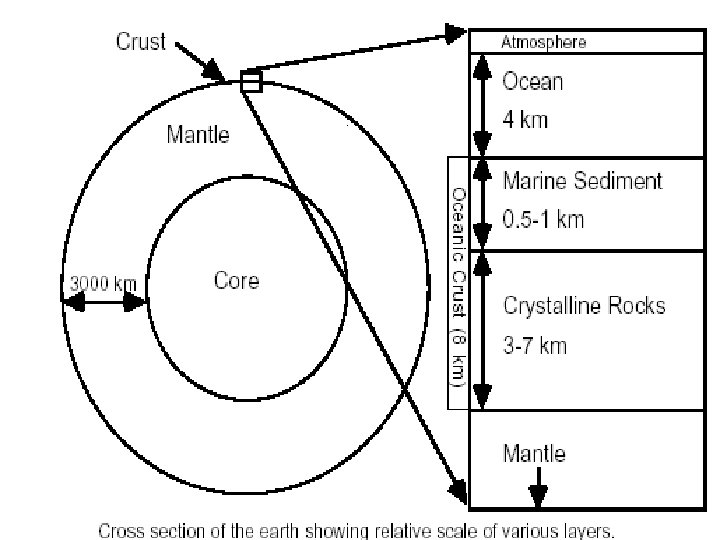
To generate seismic readings, researchers use air gun blasts in "active source" surveys
Anatahan Volcano eruption, May 11, 2003. Photo from the Commonwealth of the Northern Mariana Islands Emergency Management Office.
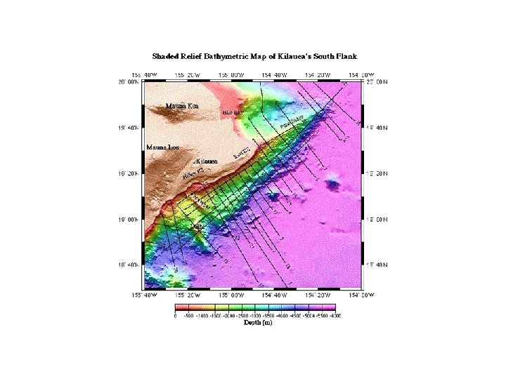
The morphology of the south flank has many features suggestive of a landslide: the Hilina fault zone, just seaward of Kilauea's summit, is thought to define the headwall of a slump. A midslope bench at about 2500 mbsl may represent the uplifted toe of the slump. The southwestern margin is defined by a lineament upon which Papa'u seamount sits. New interpretations of the flank's substructure based on the seismic data, however, suggest that some of these features may result from lateral displacement of the entire flank, rather than surficial collapse. Submarine Landslides and Flank Deformation on Kilauea Volcano, HI Investigator : Julia K. Morgan the two types of rock that we find within the heart of volcanoes like the Cumbre Vieja. It’s very loose, very permeable material, the water can soak straight down through it from the surface, down to this level within the volcano and the second type of rock is this. This is the lava dyke and it’s very hard, it’s formed by volcanic lava forcing its way up through the volcano. Once the eruption’s ended the lava in the dyke solidifies and produces this very hard rock and the important point about this rock is that it’s very impermeable. The water can’t penetrate through it, it’s trapped behind it and these dykes within the middle of each volcano act as a series of dams As water trapped between the dykes is heated by volcanic eruption, it expands, pressures increase drastically, ultimately causing the flanks of the volcano to collapse.
Hydrothermal systems at Loihi Seamount, the youngest of the Hawaiian volcanoes, is located 28 km off the SE coast of Hawaii. In July and August 1996, a large swarm of earthquakes (>4000) occurred on Loihi which led to release of intense hydrothermal plumes in the surrounding seawater and formation of a large summit pit crater. For more information about Loihi, visit the web page of The Hawaii Center for Volcanology. Magmatic processes provide the driving mechanism for hydrothermal circulation through oceanic rocks. Interactions between hot rock and seawater give rise to venting of hydrothermal fluids (<200°C to > 400°C) that form sulfide and sulfate precipitates upon mixing with sulfate-rich seawater. Many such vent sites have been observed at mid-ocean ridges where precipitates may form great chimney-like structures. Prior to the seismic events in 1996, Loihi hydrothermal vents emitted only low temperature fluids (<30° C) which precipitated iron oxide and iron-rich clay minerals. After the seismic swarm, high -temperature sulfide minerals were found in the glass sands near the margins of the newly formed pit crater and vent fluids with temperatures up to 200° C were measured. Some glass grains have rounded edges but show hardly any alteration as might be expected from reaction with hot, acidic fluids. This suggests that reactions occurred rapidly, probably while glass shards were ejected into a turbulent current. The small, euhedral crystals do not appear to be pieces of chimney-like structures or stockwork from deeper in the hydrothermal system. Most likely these crystals precipitated from a hot hydrothermal plume, violently ejected through deep fractures and fissures along the walls of the collapsing pit crater. Loihi is an an active hydrothermal system; establish linkages between fluid circulation, alteration, and geomicrobial processes, and determine relations between seismic and hydrologic anisotropy.
Giant Slumps: Relatively small rising temperature in the core of the volcano due to the injection of magma could result in very large changes in water pressures. These water pressures are large enough to produce strength in the flank and result in collapse of the volcano. What this of course means is that the next collapse will ultimately be tied to a future eruption
PLUME Seafloor Drilling Project 2003 -2005 Domal massifs capped by corrugated, striated detachment faults have been mapped at several locations on the seafloor. Formation of these large, shallow seafloor features appears to be an episodic manifestation of plate rifting and accretion at slow spreading ridges. However, currently available data are not sufficient to characterize the magmatic/tectonic/metamorphic history so that we can understand the mechanisms of uplift and emplacement of Oeanic Core Complexes. A second goal is to characterize the nature of the alteration front within oceanic peridotite. OCC expose altered upper mantle peridotites and mafic crustal rocks. The alteration of these rocks and theprocess of serpentinization greatly affect the geophysical properties of the lithosphere. Mantle seismicvelocities have been measured at depths as shallow as several hundred meters on the central dome of the massif, therefore drilling at Hawaiian s Massif offers an unprecedented opportunity to determine the nature of the Moho. Is it a hydration front rather than the crust/mantle boundary?
Hawaiian trough and flexural arch The enormous weight of the Hawaiian volcanoes on the ocean crust bends the lithosphere down, much like a piece of plywood on sawhorses would bend if you were to stand on it. Around the islands is a moat, the ~5500 m deep Hawaiian Trough. Beyond the down-warped area is an arch, levered up 200 m or so above the average depth of the ocean crust, just like the edges of the plywood would be lifted above the height of the sawhorses. Vast flows of flood basalts have been found along the North Arch, the axis of which is about 250 km north of Oahu, and also on the South Arch, south of the island of Hawaii. These flood basalts are intriguing because the locations are far from the center of the hot-spot plume, and the eruptions produced enormous volumes of very fluid lavas. On the North Arch, the nearly flat-lying sheet-like flows extend about 100 km both north and south from the axis of the flexural arch. Many of the vent lavas are highly vesicular, apparently because of degassing of CO 2. The lavas are geochemically similar to the rejuvenated-stage lavas of the Koloa (Kauai) and Honolulu (Oahu) Volcanics, and were generated by partial melting of sources similar to those of the Koloa Volcanics. Prior to eruption, these magmas may have accumulated at or near the base of the lithosphere in a structural trap created by upbowing of the lithosphere.
Photo from the Shinkai 6500 submarine of a sheet flow on the North Arch. Note thin sediment cover, indicating the relatively young age of the flow. , Photo © 1999 JAMSTEC Shinkai 6500 submersible dive 502 explored one of the composite volcanoes and found dense alkalic basalt sheet flows erupted after vesicular basanite pillow basalts and fragmental hyaloclastite that make up the steep-sided cone. Dive 503 collected alkalic basalt sheet flows and pillow basalt from the top 122 m of the southern wall of a pit crater that formed by collapse caused by a decrease in magma volume from a shallow storage chamber located 1 -2 km below the surface. The volume change may have been caused by loss of gas bubbles from the stored magma when replenishment ceased at the end of the eruption. The surficial drapery-folded sheet flow is covered by only a few cm of sediment, indicating that it is younger than the 0. 5 -1. 5 Ma ages previously estimated for North Arch flows and vents.
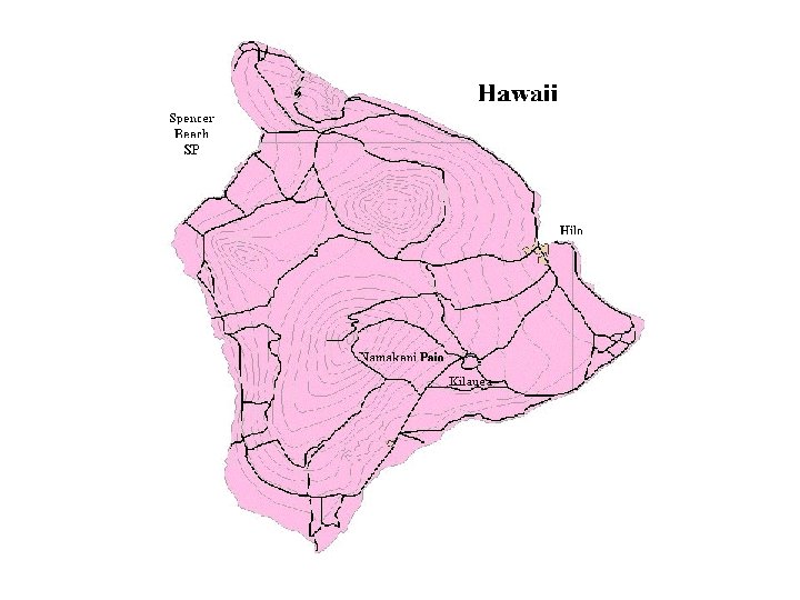
The Big Island of Hawaii is a geologic microcosm of the entire archipelago. It has five subaerial (above the ocean) volcanoes. Like the chain, the volcanoes are oldest to the northwest and youngest to southeast.