As G 1 RIVERS British Geographer AQA Website

As – G 1 RIVERS British Geographer AQA Website

Overview to Rivers

G 1. 3 The Hydrological Cycle The hydrological cycle is also known as the water cycle. Seas and oceans contain 97 per cent of the world's Evapotranspirationwater, and ice holds 2 per cent. That leaves just 1 per cent of the world's water as fresh water on land or in the air. This water is recycled again and again through the process of evaporation, condensation and water transfers such as surface run-off.
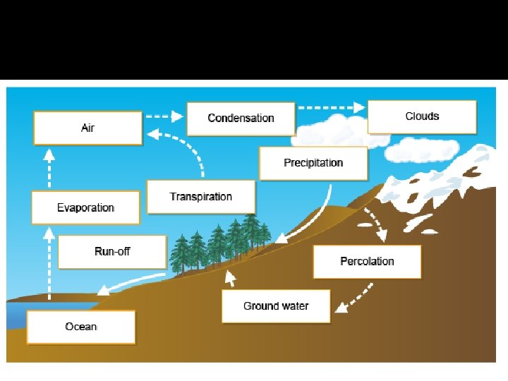

Hydrological Cycle

Hydrological cycle: Key Words � � � � � Drainage Basin: area of land drained by a river and its tributaries Watershed: boundary between two river systems on high relief land Precipitation: deposition of moisture from the atmosphere to the surface. Can be: snow, rain, sleet, snow, hail, frost, fog. . . Evapo-transpiration: release of water vapour from the earths surface in the form of evaporation and transpiration. Interception: retaining of water by plant leaves, stems and branches. Water is stopped from reaching the soil directly. Stem-flow/leaf drip: water that travels through the stem of a plant. Surface run-off/overland flow: the flow of water over the surface of the ground. Infiltration: water that soaks down into the soil. Soil moisture storage: moisture held stationary in the soil. Through-flow: the movement diagonally downward of water through the soil. Percolation: the filtering of water downwards vertically through the joints and pores of permeable rock. Through-fall: droplets of rain dripping straight off leaves and onto the ground. Groundwater flow: water that flows horizontally underground through rock. Soil saturation: when the soil contains a lot of water. Field capacity: the volume of water which is the maximum the soil can hold. Infiltration rate: the rate at which water infiltrates into the soil. Water-table: the level below which the ground is saturated. The water balance: precipitation = runoff + evapotranspiration +/- change in storage Dynamic Equilibrium: refers to balanced state of a system when opposing forces are equal. If one element in the system changes then the system changes to reach equilibrium again.

Human Effect on the Hydrological Cycle Infiltration: Humans have a serious affect on the hydrological cycle in built up areas this is because infiltration can often not happen naturally, this is due to impermeable surfaces like concrete and tarmac. However this has been combatted in many urban areas by the introduction of drains. However drains can become easily blocked and due to no infiltration urban areas can be at risk from flash flooding. As there is more surface runoff in precipitation due to no infiltration. River management techniques: for example dams like the lake Vyrnwy dam in wales this dam is 357 m long and was constructed in the 1880’s to provide fresh water to Liverpool. The dam’s construction resulted in the provision of a reservoir and the flooding of a small town. When the water in the lake is not high enough the dam will not let any water through this can cause droughts further downstream offsetting the hydrological cycle.

Irrigation: when water is taken from the river to provide water for agriculture. This can cause pollution to the water cycle through leaching and water run off of the chemicals used in farming. This can also lead to a limited supply of water down stream. This diagram shows how water is used by humans for farming and industry use.

Water balance G 1. 4 This is the balance between inputs into a drainage basin and outputs. It is important for understanding the processes operating in a drainage basin and water balances throughout the year. � It is expressed as follows: � P = Q + E (+/- change in storage) � � � P = precipitation Q = run-off E = evapotranspiration Soil moisture Surplus: If precipitation exceeds evapotranspiration and the excess is not been used by plants. Deficiency: Evapotranspiration exceeds precipitation. Recharge: Replacement of water lost during drier periods. Field capacity The maximum amount of water soil can hold. A water surplus can result in wet soils, high river levels and run-off whereas a deficit leads to dry soil, falling river levels and possibly drought. Management is shown in the example at the end of this topic. Water Deficit Evapotranspiration is in excess of precipitation and any previously available moisture has been used, in soil moisture utilisation.

Interpreting water budget models The diagram illustrates the main features of the water balance: Here are some questions and answers that will help you to learn to read the graph accurately: A) In which months is there a water surplus? B) Why is there soil moisture recharge in October? C) When is field capacity attained? D) Why is a water deficit not shown on the graph?
 In which months is there a water surplus? � Jan, Feb,")
ANSWERS � A) In which months is there a water surplus? � Jan, Feb, Mar, Apr, Nov, Dec. � B) Why is there soil moisture recharge in October? � Due to the excess of evapotranspiration over precipitation in May Sept. � C) When is field capacity attained? � November. � D) Why is a water deficit not shown on the graph? � Precipitation always far exceeds evapotranspiration.

Storm hydrographs G 1. 5 Rising limb: This is the increasing level of discharge in the river after the storm. Peak discharge: this is when there is most water in the river. Failing/Receding Limb: this is the river returning to its normal amount of discharge. Lag time: the time taken between the peak precipitation and the peak discharge. In this graph you can see it took most of a day for the precipitation to get to the river. Base Flow: the change between the start and finish of the discharge this changes due to slow through flow

hydrographs � Drainage basins all have a variety of characteristics in terms of vegetation, geology, soil type and so on, all of which interact to influence how quickly or slowly river discharge increases after a storm. Below are the major influences on hydrographs and drainage basins: � Size of basin, shape and relief Size - the smaller the basin the less time it takes for water to drain to the river, resulting in a shorter lag time. Shape - the shape of basin that lends itself to most rapid drainage is circular. In a long, narrow basin water takes longer to reach the river. Relief - the steeper the basin the more quickly it drains. Forms of precipitation Heavy Storms - in such a situation, rainfall is often far in excess of the infiltration capacity of the soil leading to much overland flow, and rapid rises in river levels. Lengthy rainfall - leads to the ground being saturated and overland flow. Snowfall - until snow melts, potential discharge for a river is held in storage. Rapid melting can lead to flooding. Temperature - High rates of evapotranspiration reduce amounts of discharge, and low temperatures can store water in the form of ice and snow. Land Use - Vegetation - Important in reducing discharge as it intercepts precipitation and adds to rates of evapotranspiration. Roots of plants take up water reducing throughflow. Interception is less in winter in the UK due the shedding of leaves from deciduous trees. Flooding is more likely in deforested areas. Geology -Rock type varies within drainage basins and can be permeable (allowing water through) or impermeable (not allowing water through). Permeable rocks can be porous such as chalk that store water within them or pervious, such as limestone where water flows along bedding plains. Impermeable rocks encourage grater amounts of surface run-off and a more rapid increase in discharge than permeable rocks. Soil - A control on the rate of infiltration, amount of soil moisture storage and rate of throughflow. Larger pore spaces as found in sand, allow for greater water storage and limit the risk of flooding. Drainage density - As stated earlier, the higher the density the greater the risk of flooding. Tides and storms - High spring tides (illustrated by the Severn Bore) prevent water from entering the sea and increase the risk of flooding. Urbanisation - A major impact because of its alteration on the hydrological process. The main affects are shown on the diagram below. Click on the magnifying glass to see the graph in more detail. � � � �

G 1. 6 �Hydrology – River Regimes �River discharge �Changing Channel Characteristics �Hydraulic Radius

G 1. 6 A HYDROLOGY –River regimes �The rivers regime is the pattern of discharge, over a year, which is followed by the river due to the seasons it encounters and what they bring. �For example a river in Britain may follow the pattern of high discharge in the winter months between October and march and have low discharge due to high temperatures of the summer in July and August.

G 1. 6. b RIVER Discharge River discharge: The volume of water flowing past a specific point. What is the unit of River discharge? Cumecs – cubic meters per second discharge (m 3 per second) = Cross sectional area (m 2) multiplied by velocity (m s-1) Discharge = Cumecs- C – (m 3 s-1) What factors affect discharge? HUMAN Physical Dams and reservoirs Weather (amount of water) Irrigation (decrease) Tide Urbanisation (increase in surface runoff) Velocity (wind) Industry Width/ depth/ path of river Agriculture Relief of land / geology / infiltration Domestic/ leisure / recreation Flow of river / land forms De/a/forestation Vegetation

G 1. 6. c Changing channel characteristics �Velocity is influenced by 3 main factors 1. Channel shape in cross section 2. Roughness of the channel bed and banks 3. Channel slope A channel shape is best described by its hydraulic radius; that is, the ration between cross sectional area and the length of the wetted perimeter.

G 1. 6. c Hydraulic Radius Hydraulic radius = cross sectional area / wetted perimeter. Hydraulic radius is a measure of the efficiency of the river channel. The higher the hydraulic radius, the more efficient the river channel is. The more efficient the river is, the more energy the water will have to move downstream (so as hydraulic radius increases, velocity increases) � carry load (so as hydraulic radius increases, the river's competence and capacity increases) � increase the rate of erosion (in the upper course, as hydraulic radius increases, there is a higher rate of vertical erosion, so gradient increases; further downstream where the river is closer to base level, as hydraulic radius increases, there is a higher rate of lateral erosion). �

G 1. 6. c Hydraulic radius � 2 rivers can have the same CSA but have different HR because their WP are different. The WP is the measure of the bed and bank which are wet by the river. This means that this can change. Therefore a river could have a higher or low HR depending on the time of year. � Channel morphology is more often a reflection of the highly erosive capabilities of a river in flood rather than the more common gentler low level of flow. � Channel roughness has a significant impact on the efficiency of flow. A channel with an irregular bed and banks or containing large calibre debris such as cobbles and boulders will experience significant loss of energy through frictional contact and turbulent flow.

G 1. 7 Energy �Hjulstrom curve �Transportation �Erosion �Deposition

Energy in a River � � � G 1. 77 When a river is at peak discharge it has a lot more energy then when it is at a low discharge this is because when the river is in flood there is far more water in the river. This means the river is more efficient because it has a higher hydraulic radius. The discharge of the river has the potential to be very dangerous! And tremendously destructive! The river can be armed with rocks and boulder. Rivers are capable of carrying out vast amounts of erosion which can transform as landscape. Forming features such as Vshaped valleys, waterfalls, and gorges. The energy in a river depends on the amount of discharge and on relief of land as the water in the river can pick up additional energy from gravity. A still body of water at any point above sea level has a certain amount of stored energy. This is potential energy, when this water starts to move the energy will be transferred to kinetic energy. Some of the kinetic energy is lost due to friction therefore there is less kinetic energy that there was of the potential energy. If the gradient is steep there will be more energy. The more energy a river has the more it can transport and the more it can erode. Lots of energy is used as the river travels down stream to overcome frictional forces from the river bed and banks. This frictional force can be especially strong at areas where the river is shallow and wide with large objects in the way. When a river has surplus energy it can erode and transport material from the river bank.

Transportation � Rivers transport eroded material downstream until they lose energy and deposits load. There are 3 types of load carried by the river. Bedload (traction, Saltation) this is the larger material which is transported along the riverbed, this material is too heavy to be picked up and carried as a suspended load. Bedload The material will be transported in two ways 1. Traction - This is when material rolls along the riverbed. 2. Saltation - This is when the material bounces along the riverbed. Dissolved load – solution this is the invisible transport of chemicals which Suspended Load have been dissolved into the river. For example This is usually very fine- grained mud and silt, which is transported within the main calcium carbonate which is dissolved when rainwater flows through or runs over limestone body of the water. It is this form of transport that makes river look dark and or chalk. murky

Transportation � The type and amount of sediment transported by a river depends on several factors: • The flow of the river, most transportation happens during a high flow when the river has most energy. • The nature of the riverbed and banks. Depending on the rock types the river is flowing through. E. g sandstone will be transported at lower energy than bigger boulders, which maybe carried in bed load rather than as a suspended load. • Human intervention- lining of river banks reduces the amount of sediment available for transport.

Erosion involves the wearing away of rock and soil found along the river bed and banks. Erosion also involves the breaking down of the rock particles being carried downstream by the river. � The four main forms of river erosion � Four main types exist: � 1. Corrasion When a river picks up material and then rubs it against its bed and banks. Erosion occurs by the process of abrasion, and is most effective during times of flood. It is the main method of both vertical and horizontal erosion. � 2. Attrition Boulders collide with one another as they move down the river, and can break into smaller pieces. Over time rocks become more rounded in appearance. � 3. Hydraulic action The force of water that hits river banks, and then pushes water into cracks. Air becomes compressed, pressure increased and the riverbank may, in time collapse. � 4. Solution/corrosion A continual process, which is as a result of the chemical composition of the water. �

Deposition When a river loses energy, it will drop or deposit some of the material it is carrying. Deposition may take place when a river enters an area of shallow water or when the volume of water decreases - for example, after a flood or during times of drought. � Deposition is common towards the end of a river's journey, at the mouth. � Deposition at the mouth of a river can form deltas - for example, the Mississippi Delta. � � � � � Deposition This happens when the velocity of a river is reduced. Then the main factors leading to deposition are shown in the table below: A Low rainfall reducing precipitation B A river entering the sea or a lake, reducing velocity C Water becoming shallower D Increase in load E River overflows its banks, depositing material on the flood plain

G 1. 8 profile of equilibrium Long profile of a river. � Stage 1 - Youth � Stage 2 – Maturity � Stage 3 – Senile
 At different stages of the river there are")
Stage 1 – Youthful Stage (upper) At different stages of the river there are different features. At the first stage which is known as the youthful stage, the features are created by high velocity, but little discharge streams. The river is narrow but often deep within a V-shaped valley. This stage has the source of the river, the source often comes from melt water springs, lakes, precipitation or marsh/bog. The river piddle in Dorset has its source in Alton Pancras and comes from marsh and bog. Due to the vertical erosion of this stage many features formed in this area are unique to this stage. The features are: � V-shaped Valleys � Interlocking Spurs � potholes � rapids and waterfalls

V-shaped Valleys and Interlocking Spurs V-shaped valleys are formed due to low discharge but high velocity. The river erodes vertically rather than horizontally. This creates deep, narrow v-shaped valleys as the has only eroded vertically and not horizontally. The river tries to find the easiest way down to sea level by cutting through the softer rock. The river doesn’t have enough power to cut through hard rock forming the interlocking Spurs therefore it weaves around them.

Potholes are usually found in places where the river flows over one solid bedrock. Potholes are round holes drilled into the rocky bed of the river by turbulent high velocity water loaded with pebbles. This type of erosion is called corrasion. Potholes are often found in the same places as waterfalls and rapids. They are formed when swilling water in a depression (eddy or whirlpool) turns the load of the water into a tool to grid out a round hole. The hole will become smooth and rounded due to attrition. Potholes are round to oval shaped holes in the bedrock of a river bed. They are created where sediment accumulates within naturally occurring small depressions on the rock surface on the river bed. Turbulent flow swirls the stones around in the depressions, widening and deepening them through the prolonged process of abrasion. As the holes gets bigger even bigger debris can become trapped in the pothole, and this material is again used as an abrasive tool.

POTHOLES � � � Potholes form mainly in the upper course of the river, in high altitude where the river channel cuts directly into the bedrock. Potholes are the direct consequence of vertical erosion and processes of abrasion. The river channel in the upper course is characterised by roughness, associated with large bedload. This is because the river doesn’t have enough power to move the bedload. As water flows over still standing bedload on river bed it is forced over the obstacle and to eddie behind the rock downstream. This turbulence forces water down on to the bedrock. Over time small depressions within the bedrock develop. We can see a similar process of turbulent wind movement and eddie development as wind collides with tall building in cities. This is illustrated below. Wind turbulence over a building similar to river eddie development Over time, the turbulent flow deepens the depression in the bedrock to form a small circular basin, just a few centimetres in diameter. This development creates a positive feedback, which further increases the turbulence of the water and the development of eddie currents. It is this turbulence which creates localised variations in the speed of erosion. The pothole is allowed to deepen It is then possible for smaller bedload to become trapped in the pothole. This debris is then used to abrade the sides of the pothole. Over time the pothole will deepen and become more circular; the diameter of the pothole increases in size and often multiple potholes form and merge as shown in the Blyde River. The Bourke Luck Potholes are particularly spectacular as the sand stone bedrock rapidly erodes forming a gorge within the river valley.

Rapids and the formation of waterfalls Rapids are most commonly found in the upper course of the river and form as a result of the river cutting down rapidly in a localised section of the river. They may form downstream of a waterfall that has retreated towards the source or they mark the point of a previous waterfall section. They can be found in other sections of rejuvenating rivers and are located at the knick point of the river. The main characteristics of rapids are distinctly steeper gradients marked by steps in the channel and high turbulence, which is the result of large bedload in the channel. It is common that rapids form over different bands of geology that vary in resistance or where the river is transporting large resistant bedload. The velocity of the river is noticeably faster at rapids but not efficient in its flow. Due to the roughness of the channel, flow is turbulent and known as white water. This white water is thrown up and characterised by eddie currents. Waterfalls like rapids form mainly in the upper course as a result of differentiated erosion. If the river channel flows across different bands of rock with varying resistence, then the softer less resistent rock will be eroded faster creating a step in the river. The hydraulic action of the water enlarges this step over time creating the waterfall. Due to the force of the water a deep plunge pool forms at the base of the waterfall. Turbulent flow with eddie currents and splashback undercuts the cap of resistent rock headwardly, untill the undercut is significant enough for the rock above to collapse under its own weight. This leaves angular resistent bedload in the plunge pool, which will combine with hydraulic action to further deepen and undercut through the process of abrasion. Over time the waterfall becomes higher and retreats upstream. As the waterfall retreats a deep gorge with steep U-faced sides forms down the length of the river and marks the length of retreat. Waterfalls are a significant example of both vertical and headward erosion. The process is visualised in the animation Next slide

Waterfalls
 Meanders Oxbow lake Levees Riffles and Pools Flood")
Stage 2 – mature (middle course) Meanders Oxbow lake Levees Riffles and Pools Flood Plains In this stage the gradient is less than the upper course. The valley at this stage of the river is a U-shape. The interlocking spurs of the upper course have become Truncated spurs as the river now has more discharge and energy to be able to erode through the spurs. The erosion is now more lateral rather than just vertical.

Meanders are sweeping loops or bends in the middle and lower course of the river caused by rivers developing increased sinuosity downstream. Meanders form through a combination of factors. These factors can be the river's attempt to balance its energy, velocity, bedload and discharge. Or can be factors relating to the channel gradient and channel roughness. Meanders flow due to the maximum flow of the river turning round a bend. This maximum flow causes erosion on one side of the river and deposition on the other side. This is because the majority of the discharge is pushed to one side of the river. This means more energy is available on this side to erode the riverbank to form as river cliff. However on the other bank of the river there is less discharge this means that there is also less energy there for the river drops its load (deposition) this creates a slip off slope.

Ox-bow lake One feature closely associated with meanders are ox-bow lakes. They are similar because they originate from meanders. Due to the eroding capability of the river the gap between two point of the meander will be worn away and due to deposition the load will be dropped severing the link between the oxbow lake and the main flow of the river. You can see this in the diagrams on this slide. (See Helical Flow)

Helical Flow The helical flow of water plays an important role in the formation of meanders, especially in developing river cliffs and slip-off slopes. Higher velocity chutes within a stream tend to be driven to the outside of a meander seen at point 1. On the outside of the meander, the surface of the water has a tendency to be slightly higher because it has gained momentum and acceleration, in the same way as centrifugal force works. Here, the flow is forced down the outer bank which results in the scouring of the bank and bed. It returns to the surface toward the inside of the meander where flow is less turbulent, seen at point 2. The helical flow continues to erode the outside of the bend and deepens the pool. (4) At the same time it redistributes scoured material and deposits it on the slip-off slope and riffle section (5/2). This continuous process cause meanders to migrate and contract at their neck. Overtime the meander neck becomes narrower until the river cuts directly through, forming a channel cut-off and ox-bow. In time, the ox-bow will be cut off entirely through deposition to form an ox-bow lake. (see oxbow lake)

Riffles and Pools Riffles and pools are also associated with meanders, as well as the normal flow of the river. Riffles are shallow areas of the river channel often these areas have less velocity and are the points where deposition occurs. Pools are deeper sections of the river channel, these often have a greater velocity and therefore these are the points where erosion occurs. Riffles and pools often alternate from one side of the channel to the other. The pattern of riffle and pool distribution corresponds directly to the meander length.

Levees Natural levées form as the river floods its banks and inundates the floodplain. As soon as the river overflows the bank, it comes in contact with greater surface area and friction. This increased friction reduces the velocity and energy of the river and its ability to transport bedload. As a result, the river has declining competence with distance away from the banks. Consequently, the river deposits larger load first but continues to transport finer sediments further across the floodplain. The sediment profile therefore falls in size from the bank to the bluff. Due to larger bedload being deposited closer to the bank becomes raised, forming gentle sloping banks towards the floodplain.

Floodplains As we have already learned, rivers increase in discharge as they move downstream. This in turns creates a wider and deeper channel and in the river's efforts to balance its energy the river becomes more sinuous and meanders develop. Intermittently, the rivers discharge will exceed the capacity of the river channel and overflow the river banks. In the early stages of floodplain development, a river cuts out its floodplain as its channel migrates. Channel migration, whereby the river changes direction and location is common in unregulated rivers. The river then deposits alluvium on its floodplains. Over time the floodplain will become wider and have greater depth due to sediment build up. Most floodplains were created at the end of the last ice age when the rivers had a high discharge due to melt water.
 At this point in the rivers course the")
Stage 3 – senile (Lower course) At this point in the rivers course the river sits in a flat bottom valley. Often surrounded on both sides by flood plains. This part if the river has the least gradient, but the most discharge, this is due to the tributaries all having joined the river by this stage, the river however has a slower velocity at this point this is because of little gradient. Erosion at this point of the river is only lateral and so the river gets very wide. Towards the end of the river there can be a lot of deposition this forms a delta. A lot of the features of the middle course also appear in the lower course of the river. Braided Channel Deltas and Distributaries

Braided channels � Braided channels can form nearly anywhere along the course of the river Braided channels are common river regimes, which are characterised by significant fluctuations in discharge and resulting capacity to transport bedload. They are common in Alpine rivers with significant snow melt as well as in dry/wet tropical climates that experience extreme rainfall events. Many arid and semi-arid regions have braided river channels. This occurs when the channel of the river is split up by islands called islets. This could be artificial or natural. A river can get very wide and shallow therefore easily eroding because of the type of rock but quickly depositing to form the islets. Braiding also occurs when there are changing discharges for example on melt water streams or in tidal estuaries at point when the river is high there is no braiding but when the river is low the channel is narrow and flows between islets.

Deltas � � � River deltas form at the mouth of the river or inland on the approach to lakes. There is great variation in the shape of deltas due to the complex interaction between fluvial and marine systems. There a number of ways to classify delta shape. The most common is to broadly identify them as arcuate, cuspate or birdfoot in form as, illustrated in the diagram above. Their shape is influenced by the amount and type of sediment being transported by the river, the velocity, discharge and capacity of the river and the strength of marine tides and waves. Arcuate deltas like that found on the Nile are the most common type of delta. They are characterised by a gently curving shoreline, smoothed by longshore currents. They have a distinct pattern of branching distributaries and tend to be dominated by courser material. Birdfoot deltas, are more distinct and are dominated by an extruding finger-like branch of deposition. They have fewer distributaries and fine sediments. They are formed due to weaker marine processes and high discharge. Finally, the cuspate delta is a little more difficult to recognise. They are quite varied but generally take on a tooth-like form. They are shaped by a gentle but regular opposing marine process. They are sometimes subject to longshore drift which redistributes the sediment along the coast. Deltas only form in areas where the amount of sediment supply exceeds the rates at which it is removed. The extent to which sediment is removed is an important factor therefore in determining the delta shape. When rivers with high capacity reach the sea they encounter opposing tidal and wave currents. In the marine environment freshwater is also coming into contact with salt water, known as brackish water. At this interface, fine muds and clays transported in suspension coagulate with salt in a chemical reaction called flocculation. This process makes them heavier and they sink to the bottom. This process produces a varied composition of sediment in the Delta. Typically there are three types of sediment, Topset beds, Foreset beds and Bottomset beds. Topset beds are made up of larger bedload and are deposited first. Foreset beds are made up of more middle calibre sediments and are therefore transported a little further. They form steep like wedges, (illustrated below). Finally Bottomset beds, are finest sediments and therefore travel the furthest before low velocity and/or flocculation causes them to be deposited. See diagrams on next slide.

Delta
- Slides: 43