Archaeological Landscape of Clashmore Kinsalebeg Heritage Group December

Archaeological Landscape of Clashmore & Kinsalebeg Heritage Group December 2019
 • Neolithic (first farmers)")
Prehistoric & historic periods in Ireland • Mesolithic (hunter gathers) • Neolithic (first farmers) • Bronze Age (metallurgy) • Iron Age • Early medieval period • Medieval (Anglo Normans/towns) • Late Medieval • Early Modern 10, 000 – 4, 000 BC 4000 – 2500 BC 2500 – 500 BC – 400 AD 400 – 1000 AD 1000 – 1500 AD
 & National Inventory of Architectural Sites (NIAH) •")
Record of Monuments & Places (RMP) & National Inventory of Architectural Sites (NIAH) • www. archaeology. ie • National Monuments Service • Archaeological Survey Database • Map of Ireland • Search by townland name

Townland RMP Site type Period Clashmore WA 037 -007 Holy well Early medieval Clashmore WA 037 -008001 Church Early medieval Clashmore WA 037 -008002 Church Medieval Clashmore WA 037 -008003 Graveyard Medieval - Modern Clashmore WA 037 -008004 Cross inscribed stone Clashmore WA 037 -008005 Ballaun stone Early medieval Kilgabriel WA 038 -001 Church Early medieval Kilmaloo East WA 037 -027001 Enclosure church Early medieval Kilmore WA 034 -036 Enclosure Early medieval Knockanearis WA 034 -024001 Ecclesiastical enclosure Early medieval Knockanearis WA 034 -024002 Ballaun stone Early medieval

Ballaun Stone Clashmore WA 037 -008005

Enclosure WA 034 -036 in Kilmore on 1840 map

Enclosure WA 034 -036 in Kilmore on modern aerial photograph

Enclosure WA 034 -036 in Kilmore townland • Description: Marked as a large embanked subrectangular, possibly bivallate enclosure on the 1840 map. (ext. dims. 230 m ENE-WSW x 90 m NNW-SSE), and with a single bank on the 1927 map. (ext. dims. c. 260 m ENE-WSW; c. 110 m NNW-SSE) of the OS 6 -inch map. It incorporates the townland boundary with Coolbagh at N and is situated at the bottom of a N -S valley with a N-S stream c. 20 m to the W. This is a rectangular grass-covered area (int. dims. 220 m E-W x 80 -92 m NS) defined by a substantial, overgrown earthen bank (at W: Wth 6 -7. 5 m; int. H 1. 2 -2. 5 m; ext. H 1. 3 -4 m) and outer fosse (Wth at base 2. 5 -4. 5 m; D 0. 81. 2 m) which is best preserved at W. The entrance (Wth 3. 8 m) and causeway at W are probably modern, as are subsidiary entrances at E (Wth 3. 8 m) and at the E end of the N side (Wth 3. 5 m). The site may have originally consisted of three fields which were later broken into a single large field. It is regarded as a church site by Power (1952, 90).

Ecclesiastical enclosure WA 034 -024001 in Knockanearis on 1840 map

Ecclesiastical enclosure WA 034 -024001 in Knockanearis • Description: Marked as a large oval embanked enclosure (ext. dims. c. 90 m NW-SE x c. 70 m NE-SW), or a bivallate enclosure (int. dims. c. 60 m NW-SE; c. 40 m NE-SW) on the 1840 ed. of the OS 6 -inch map and situated in pasture on a SE-facing slope. It has been described as a church site known as Cill Choluim Deirg, but a holy well at its W edge had been reclaimed before 1900 (Power 1952, 90). Locally, it is associated with an ‘altar stone’ or a stone with a basin that could be a bullaun stone, but which cannot be found now. Apart from a curving field bank and townland boundary with Craggs W-N-E, which may respect the line of an enclosure, nothing is visible at ground level. It is bisected by an E-W farm lane.

Site of Church in Kilgabriel & Kilmaloo East on 1840 map

Townland RMP Site type Period Ballindrumma WA 035 -001001 Ringfort Early medieval Ballindrumma WA 035 -001002 Souterrain Early medieval Ballycurrane North WA 035 -011 Ringfort Early medieval Craggs WA 034 -022001 & 002 Ringfort & souterrain Early medieval D'Loughane WA 037 -016 Ringfort Early medieval D'Loughane WA 037 -017 Ringfort Early medieval Knockanearis WA 034 -021 Ringfort Early medieval Knockanearis WA 034 -023 Ringfort Early medieval Pilltown WA 037 -028 Ringfort Early medieval Tinnabinna WA 037 -026002 Ringfort Early medieval

Ringfort & souterrain in Craggs WA 034 -022001 & 002

Ringfort & souterrain in Ballindrumma WA 035 -001001 & 002

Comparative early medieval sites excavated on infrastructural road projects • Cashel in Owenbristy Co Galway on route of N 18 • 7 th – 10 th century cemetery settlement site • Reused as Cillin site in the 13 th century • Ringfort and souterrain in Mackney Co Galway on route of N 6

Owenbristy circular stone enclosure 44 m in diameter

Reconstruction drawing of Owenbristy

96 burials in Owenbristy. 75 dated to EMP

Iron collar from Owenbristy – crouched burial - slave collar?

Violent death at Owenbristy • Sharp force cut marks identified as either blade wounds from swords and/or axes or stab wounds from knives were identified in 12 individuals. 7 were decapitated. • 8 were tall robust male skeletons – warrier class? • Plus 2 adolescents & 2 females • Female (Sk 73) aged 25 -35 years, had suffered extreme facial mutilation – 6 stab wounds & eventual decapitation
 facial mutilation")
Female (25 -35 yr, SK 73) facial mutilation

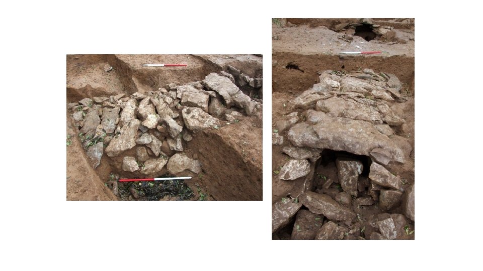
Mackney Ringfort

Souterrain in Mackney

Scale of the souterrain in Mackney Ringfort
- Slides: 26