Arc GIS Collector and Accuracy of Location and


 • Accuracy level – Assisted")


- Slides: 29
Arc. GIS Collector and Accuracy of Location and Data 2017 Indiana GIS Day and Conference Joe Madej Seiler Instrument October 24, 2017
Today’s agenda • • Arc. GIS Collector Pros and cons of dedicated GNSS units Trimble Catalyst How Arc. GIS Collector handles metadata associated with data collection
Poll
What is ESRI Collector? • A smart device application used in the field to collect and update spatial data • Puts mapping in the hands of field workers to improve the accuracy of your spatial data • Use your smartphone or tablet to collect in real time or disconnected
Uses for Collector • • • Track emergency vehicles during the Boston Marathon Manage large events such as NASCAR Tree Inventory Asset Location Disaster Relief
ESRI Collector for Arc. GIS • Simple toolbar • Common smart device zoom and pan methods • Swipe • Pinch to zoom and Expand • ESRI Background Maps
ESRI Collector for Arc. GIS System Requirements: • Android 4. 2 or later • i. OS 8 or later • Windows 10
Arc. GIS Online Account Requirements • Level 2 Member – Can view, create, and share content • Portal for Arc. GIS 10. 4. 1 is supported
Limitations with Consumer. Grade Smart Devices • Availability (network) • Accuracy level – Assisted GPS (A-GPS) • ~ 5 -8 m – Wi-Fi Positioning • ~ 74 m – Cellular Network Positioning • ~ 600 m
A Comparison: Mapping-Grade GNSS Devices vs. Consumer-Grade Smart Devices
HOW DO WE BRIDGE THE GAP TO ACHIEVE HIGHER ACCURACY?
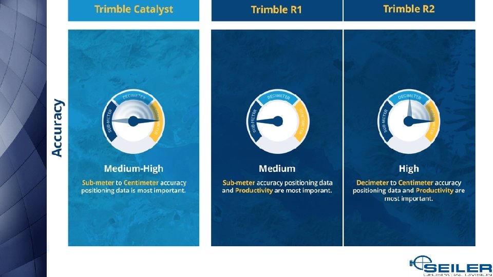
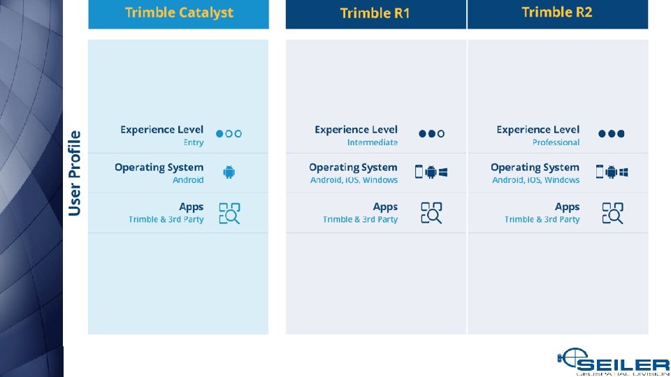
What are my options? • • • Bad Elf GNSS Surveyor, GPS Pro, and GPS Pro+ Dual XGPS 150 A and XGPS 160 Eos Arrow Lite, Arrow 100, Arrow 200, and Arrow Gold Garmin GLO¹ Geneq Sx. Blue II and Sx. Blue III² Juniper Geode Leica GG 03¹, GG 04, and Zeno 20¹ Septentrio Altus NR 2 and Altus Geo. Pod² Spectra Precision SP 60¹ and Mobile. Mapper 300¹ Trimble Catalyst Trimble R 1, R 2, R 8 s¹, and R 10¹
Accuracy vs Precision
Catalyst Solution Trimble Catalyst is a solution that includes: a software GNSS receiver and subscription service that runs on Android smartphones and tablets a small, lightweight antenna for quality GNSS signal reception Trimble or 3 rd Party apps that use the Catalyst position
Catalyst Solution Software GNSS Technology A software GNSS receiver allows for users to access a range of GNSS accuracy levels on their mobile device, from 1 meter to a few centimeters, on-demand. Many applications need higher precision than a phone or tablet’s internal GNSS solution can provide, but they don’t need it all the time or can’t justify an up front capital investment. Catalyst is available as a subscription to meet this type of demand.
Catalyst Solution DA 1 Digital Antenna High accuracy GNSS needs to have high quality signal reception from GNSS constellations. Trimble created the DA 1 digital antenna to plug directly into Android phones and Tablets to achieve this, while remaining lightweight and compact enough to fit into a backpack or vehicle glove box. Catalyst Website
Catalyst Solution Subscription Accuracy Levels
Customer Story – Collector & Catalyst • City of Centennial, CO and CH 2 M
GNSS Metadata • Besides geographic coordinates, you might also want to save other GPS metadata associated with a feature such as its accuracy and fix type • This metadata can be valuable to assess data quality and ensure data collection standards have been maintained • You can add GPS metadata fields to a point feature service so Collector can write GPS metadata to the respective fields when editing point features.
Publish a Map with GNSS Metadata • Configuring a feature service to store GNSS metadata • Create two domains in your database Note: Hosted feature layers created in Arc. GIS Online or Portal for Arc. GIS do not support adding domains.
GNSS Metadata
Keep in Mind • GPS metadata fields are populated on point layers only. • If a point feature is created or updated by long pressing the map instead of using GPS, the GPS metadata fields are cleared. • If a point feature is created or updated and GPS metadata information is not available for the GPS position, the GPS metadata fields are cleared.
The Aurora Project • Better maps – Support for vector basemaps • Improved user experience – Better layout and easier to capture accurate data locations • Smarter Forms – Conditional logic, grouping, and ordering of attributes • Enhancements to High Accuracy 3 D Data Collection – Vertical Datum Transformations
Questions?
Blog: mapsupport. seilerinst. com or Email: mapsupport@seilerinst. com St. Louis ● Kansas City ● Milwaukee ● Indianapolis ● Iowa ● Chicago
Catalyst Solution Subscription Accuracy Levels