AQUIFER MAPPING ARTIFICIAL REACHARGE STRUCTURES ROLE OF CGWB
")
AQUIFER MAPPING ARTIFICIAL REACHARGE STRUCTURES ROLE OF CGWB by Vidya Nand Negi (Scientist ‘D’) CENTRAL GROUND WATER BORAD NHR, DHARMSALA

Central Ground Water Board Consultation with regional offices of CGWB • Decisions with the aquifer maps made available for finalizing the location of the proposed water bodies • Details of design of structures required for ground water recharge specific to regions, under planning consideration • Possible scope of services from Regional Offices, CGWB in preparation of a scientific plan for NRM works

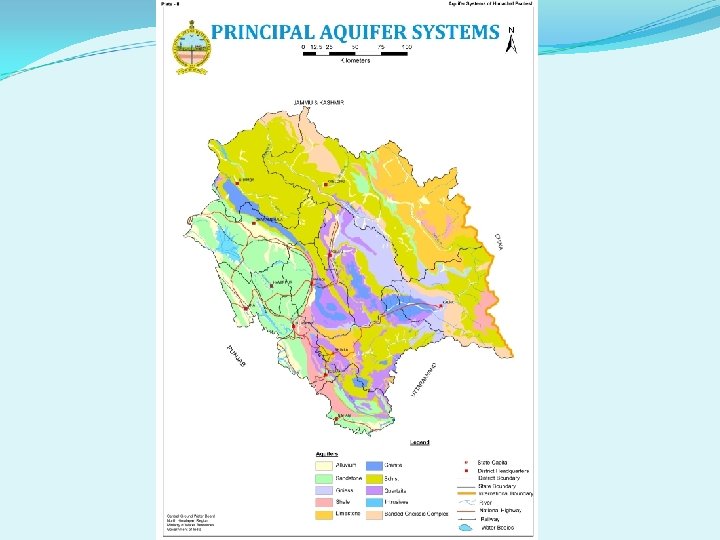
AQUIFER MAPPING

HYDROGEOLOGY ¬ VALLEY FILLS Moderate to High Yield 10 – 30 lps ¬ SIWALIKS (Low to Moderate Yield) 5 – 15 lps ¬ CRYSTALLINES / METAMORPHICS (Low to Moderate Yield) 2 – 10 lps

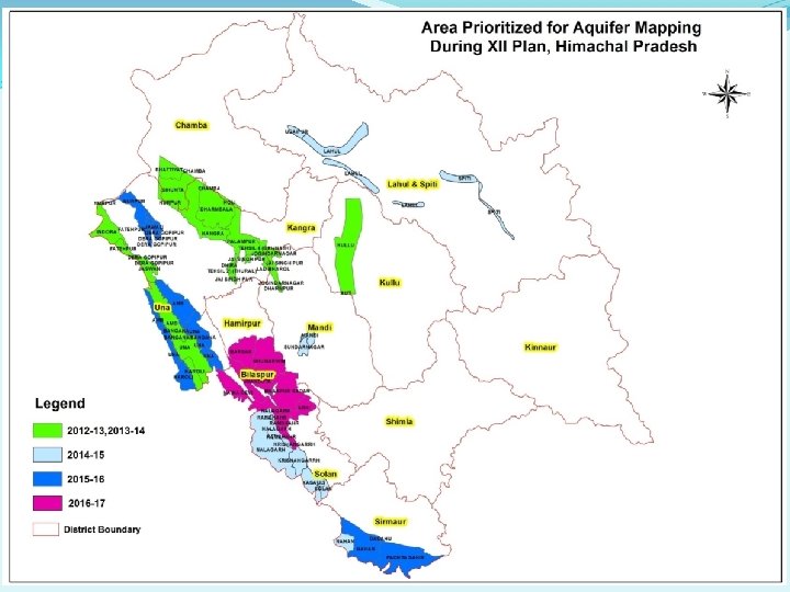
Areas takes up for Aquifer mapping Programme in Himachal Pradesh Total Area: 7660 sq km AAP 2012 -13 2013 -14 2014 -15 Area Kull Una- Kang u Valle gra- ra - Vall y Cha Pala ey mba mpur Valle y Indua ra Valle y Laha ul Valle y Area 516 577 859 in Sq km Total 1952 area in sq km 320 375 688 1008 2015 -16 201617 Spiti Balh Nala Nurp Parts Poa Kala Parts valle - V gargh urof nta - Bilas y alley - Valle Una Vall Amb pur, L&S Valle y ey Hami y Vall rpur ey and Solan 122 101 838 248 735 712 81 1488 1436 1776 1488

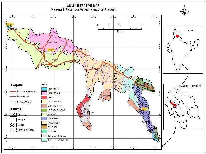
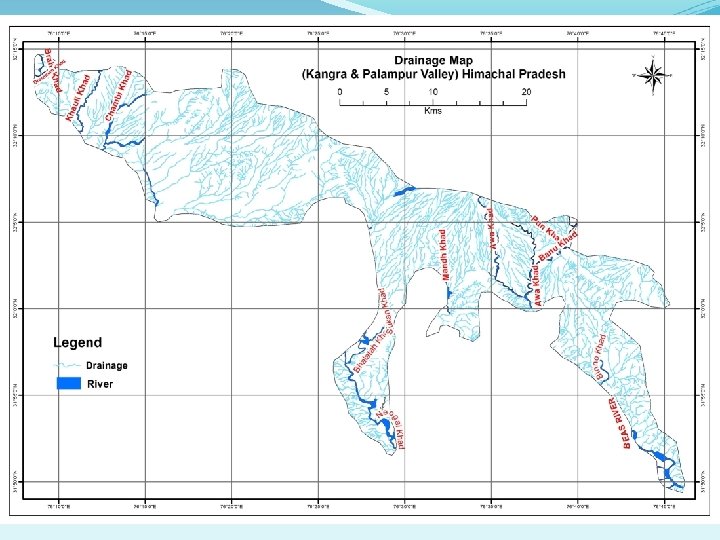
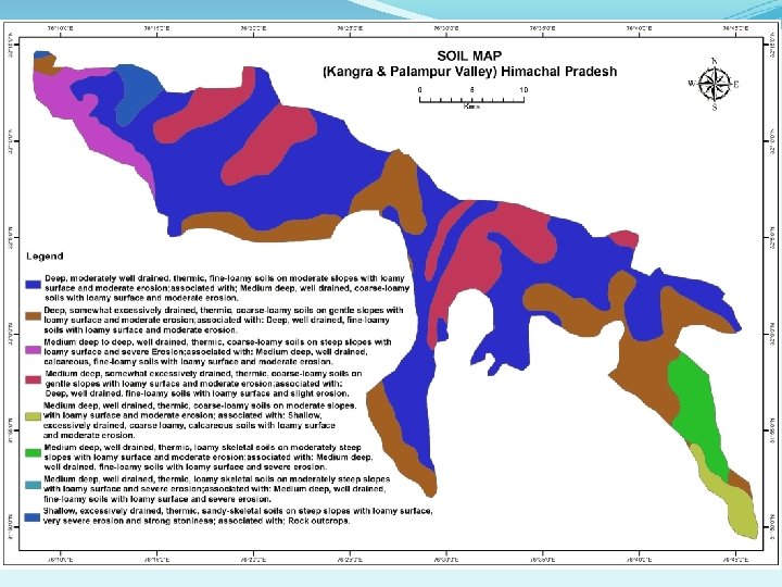
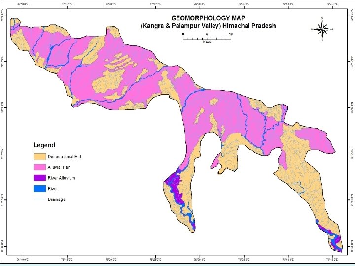
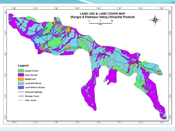
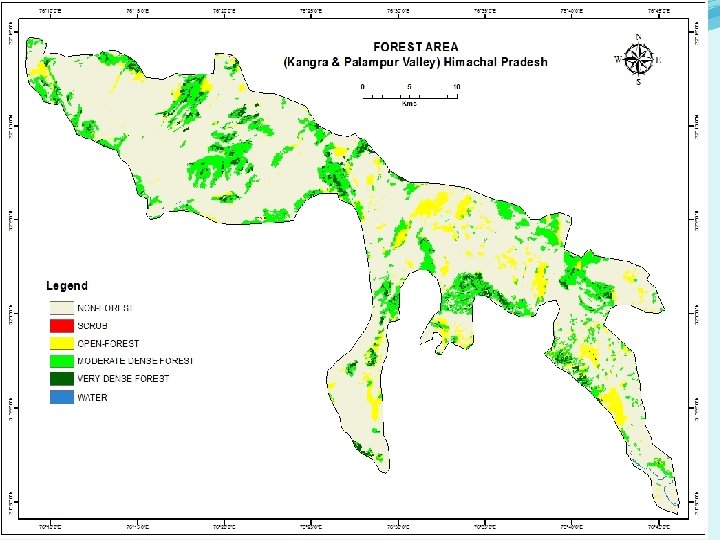
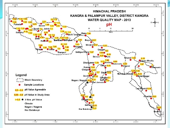
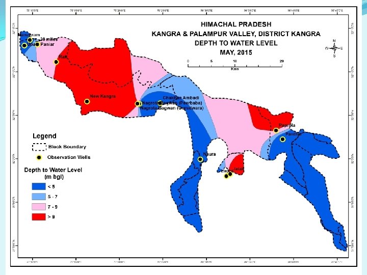
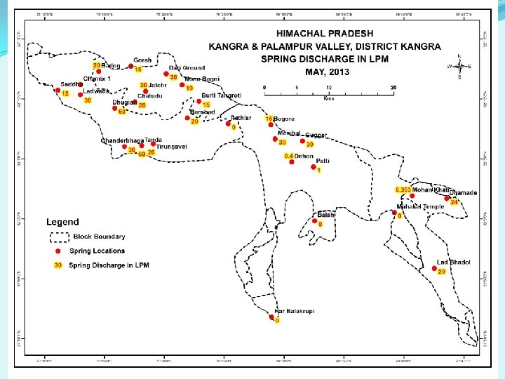
KANGRA - PALAMPUR VALLEY, KANGRA DISTRICT, HIMACHAL PRADESH

Source: G. S. I

METHODS & TECHNIQUES for ARTIFICIAL REACHARGE TO GROUND WATER Urban Areas Roof Top Rain Water harvesting through i) Storage tanks ii) Recharge Pit iii) Recharge Trench iv) Recharge Well v) Tubewell vi) Recharge shaft vii) Abandoned dugwell Rural Areas Rain Water Harvesting through i) Gully Plug ii) Contour Bund iii) Gabion Structure iv) Percolation tank v) Check Dam/ Cement Plug/ Nala Bund vi) Recharge shaft vii) Dugwell Recharge viii) Ground Water Dams/Subsurface Dyke

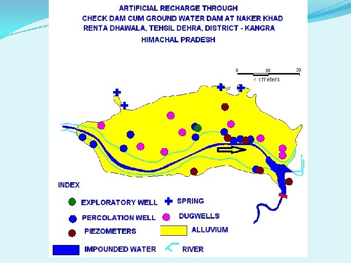
GROUND WATER DAMS OR SUB-SURFACE DYKES

IMPACT ASSESSMENT v Rise in water level by 0. 03 m to 4. 10 m v Revival of Shallow wells and springs. v Area experienced rise in ground water level by 25 % v Increase in ground water storage by 25 % v Saving of energy during pumping. v Reclamation of eroded land into agricultural fields. v Generation of employment through 1. Fisheries 2. Availability of Construction material 3. Recreation activities v Increased agricultural/ Cash crops

11/25/2020

11/25/2020

11/25/2020

GROUND WATER RESOURCE ESTIMATION
 Stage of")
Comparison of Stage of Ground Water Development Name of Valley Area (ha) Stage of Ground Water Development (%) (2009) Indora Nurpur Balh Paonta Kala Amb Nalagarh Una Hum 26545 23775 9500 15627 250 23849 49300 2200 151046 Stage of Ground Water Development (%) (2011) 50. 01 36. 44 27. 84 27. 30 248. 57 50. 72 97. 63 66. 57 58. 39 (2013) 52. 43 42. 95 32. 30 28. 23 564. 63 54. 55 124. 04 99. 57 71. 13 69. 07 29. 58 34. 50 14. 26 410. 86 47. 61 74. 43 90. 29 50. 91

Sl. No. ASSESSMENT OF DYNAMIC GROUND WATER RESOURCES OF HIMACHAL PRADESH ASSESSMENT UNIT-WISE CATEGORIZATION as on March 2013 Assessment Unit/Sub Stage of Pre-monsoon Post-monsoon Category Unit* 1 1. 2. 3. 4. 5. 2 A. Indora valley Kangra District B. Nurpur valley Kangra District A. Balh valley Mandi District A. Paonta valley Sirmour District B. Kala Amb valley Sirmour District A. Nalagarh valley Solan District A. Una valley Una District B. Hum valley Una District 25 -11 -2020 Ground Water Development (%) 16 Water level Is there a Trend significant decline (Yes/ No) Water level Trend Is there a significant decline (Yes/ No) (Safe/ Semi-critical/ Critical/ Overexploited) 69. 07 Falling No Safe 29. 58 Rising No Falling No Safe 34. 50 Rising No Safe 14. 26 Falling No Rising No Safe 410. 86 47. 61 Falling Yes Over-exploited Falling No Safe 74. 43 Falling No Safe 90. 29 No observation wells Critical

ROLE OF CGWB in preparation of Scientific Plan for Natural Resource Management Major activities being taken up by Central Ground Water Board in Himachal Pradesh State : Ø Micro and Macro level ground water management studies. Ø Exploratory drilling under National Aquifer Mapping and Management Programme. Ø Monitoring of ground water levels and water quality through a network of ground water observation wells, implementation of demonstrative schemes for artificial recharge and rainwater harvesting for recharge augmentation. Ø Periodic assessment of replenishable ground water resources of the State is carried out by the Board jointly with the I&PH Deptt, Govt. of Himachal Pradesh.

Ø The data generated from various studies taken up by CGWB provide a scientific base for water resource planning by stakeholders. Ø Short term hydrogeological investigation for feasibility of constructing tube wells. Ø Technical assistance for constructing Ground water recharge structures in the State. Ø Impart trainings on different aspects of ground water conservation and its management like Tier-II, Tier III (NGWT & RI) and Block level training under Jal Kranti Abhiyan. Ø Board is engaged in various activities related to regulation of ground water development to ensure long-term sustainability of ground water.

aquavn@rediffmail. com +91 -9418096939 +91 -1892 -227160 +91 -9805516939 www. cgwb. gov. in SAVE WATER SAVE LIFE 25 -11 -2020
- Slides: 31