APPLICATIONS OF METEOSAT SECOND GENERATION MSG METEOROLOGICAL USE

- Slides: 101

APPLICATIONS OF METEOSAT SECOND GENERATION (MSG) METEOROLOGICAL USE OF THE SEVIRI IR 3. 9 CHANNEL Author: Jochen Kerkmann kerkmann@eumetsat. de Contributors: D. Rosenfeld (HUJ), H. J. Lutz (EUM) J. Prieto (EUM), M. König (EUM) Version 1. 1, 30 June 2004 Slide: 1

IR 3. 9: WEIGHTING FUNCTIONS Version 1. 1, 30 June 2004 Slide: 2

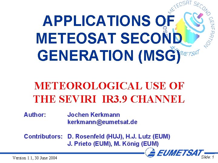
IR 3. 9 Weighting Function Max. signal from the surface, but IR 3. 9 recieves substantial contribution from the upper troposphere Version 1. 1, 30 June 2004 Slide: 3

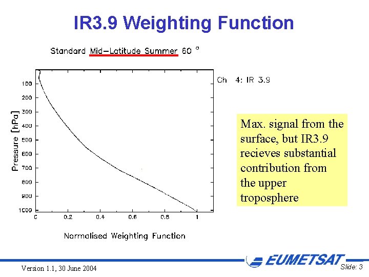
IR 3. 9 Weighting Function The contribution from the upper troposphere is larger in cold, winter conditions Version 1. 1, 30 June 2004 Slide: 4

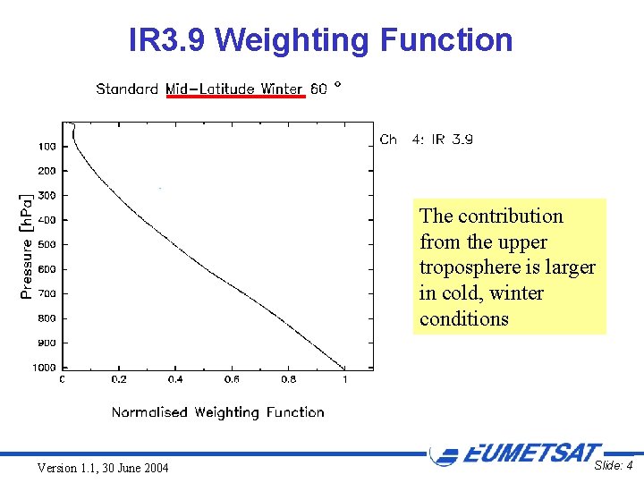
IR 3. 9 Weighting Function The weighting function for tropical areas (Nadir viewing) is similar to the one for Mid Latitudes Summer (60° viewing) Version 1. 1, 30 June 2004 Slide: 5

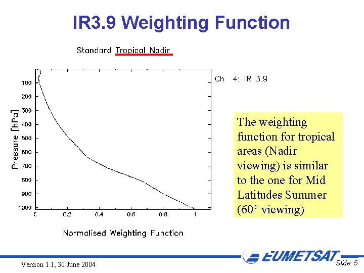
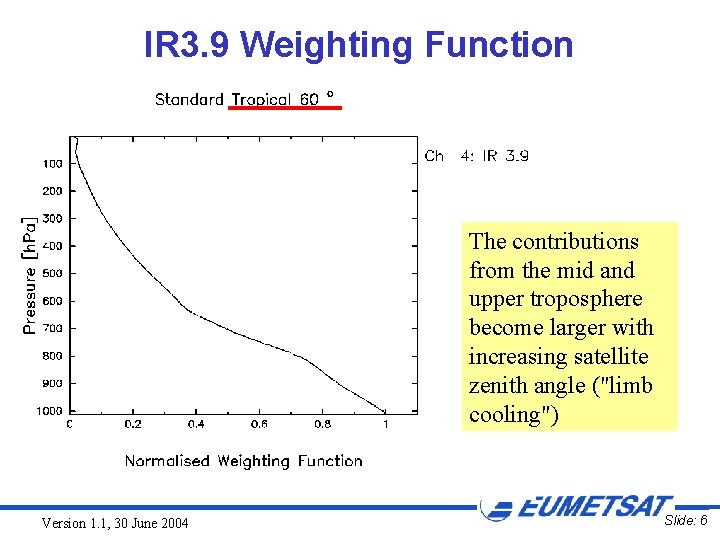
IR 3. 9 Weighting Function The contributions from the mid and upper troposphere become larger with increasing satellite zenith angle ("limb cooling") Version 1. 1, 30 June 2004 Slide: 6

IR 3. 9: CO 2 ABSORPTION Version 1. 1, 30 June 2004 Slide: 7

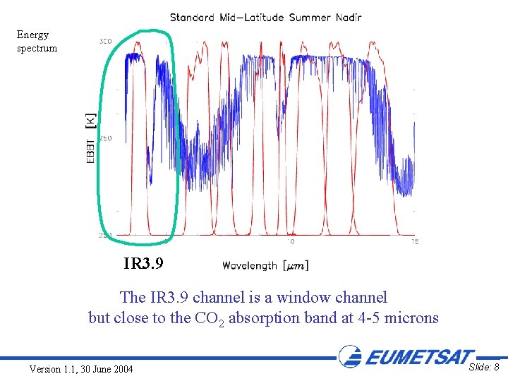
Energy spectrum IR 3. 9 The IR 3. 9 channel is a window channel but close to the CO 2 absorption band at 4 -5 microns Version 1. 1, 30 June 2004 Slide: 8

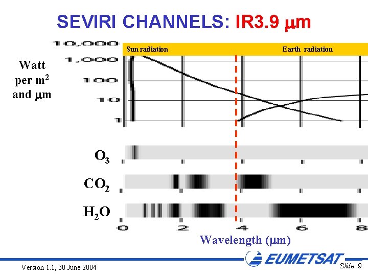
SEVIRI CHANNELS: IR 3. 9 m Sun radiation Earth radiation Watt per m 2 and m O 3 CO 2 H 2 O Wavelength ( m) Version 1. 1, 30 June 2004 Slide: 9

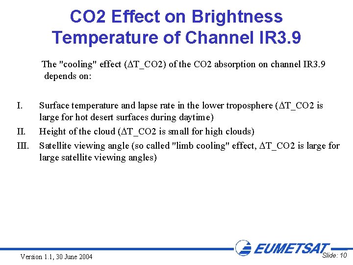
CO 2 Effect on Brightness Temperature of Channel IR 3. 9 The "cooling" effect ( T_CO 2) of the CO 2 absorption on channel IR 3. 9 depends on: I. III. Surface temperature and lapse rate in the lower troposphere ( T_CO 2 is large for hot desert surfaces during daytime) Height of the cloud ( T_CO 2 is small for high clouds) Satellite viewing angle (so called "limb cooling" effect, T_CO 2 is large for large satellite viewing angles) Version 1. 1, 30 June 2004 Slide: 10

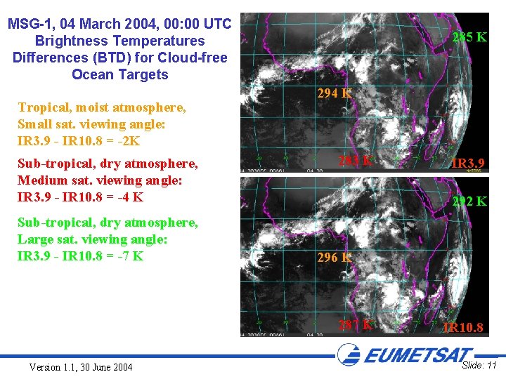
MSG-1, 04 March 2004, 00: 00 UTC Brightness Temperatures Differences (BTD) for Cloud-free Ocean Targets Tropical, moist atmosphere, Small sat. viewing angle: IR 3. 9 - IR 10. 8 = -2 K Sub-tropical, dry atmosphere, Medium sat. viewing angle: IR 3. 9 - IR 10. 8 = -4 K Sub-tropical, dry atmosphere, Large sat. viewing angle: IR 3. 9 - IR 10. 8 = -7 K 285 K 294 K 283 K 292 K 296 K 287 K Version 1. 1, 30 June 2004 IR 3. 9 IR 10. 8 Slide: 11

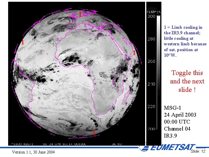
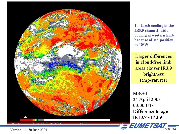
1 1 = Limb cooling in the IR 3. 9 channel; little cooling at western limb because of sat. position at 10°W. Toggle this and the next slide ! 1 Version 1. 1, 30 June 2004 MSG-1 24 April 2003 00: 00 UTC Channel 04 IR 3. 9 Slide: 12

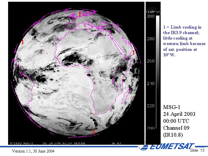
1 1 Version 1. 1, 30 June 2004 1 = Limb cooling in the IR 3. 9 channel; little cooling at western limb because of sat. position at 10°W. MSG-1 24 April 2003 00: 00 UTC Channel 09 (IR 10. 8) Slide: 13

1 1 = Limb cooling in the IR 3. 9 channel; little cooling at western limb because of sat. position at 10°W. Larger differences in cloud-free limb areas (lower IR 3. 9 brightness temperatures) 1 Version 1. 1, 30 June 2004 MSG-1 24 April 2003 00: 00 UTC Difference Image IR 10. 8 - IR 3. 9 Slide: 14

IR 3. 9: SOLAR AND THERMAL CONTRIBUTION Version 1. 1, 30 June 2004 Slide: 15

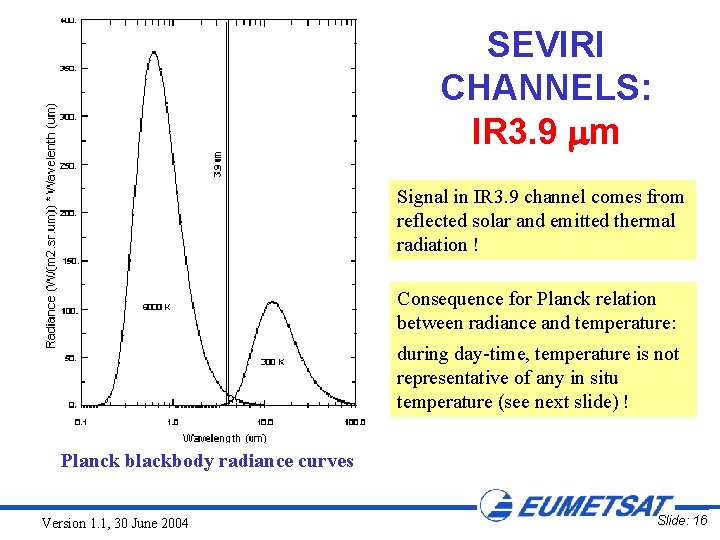
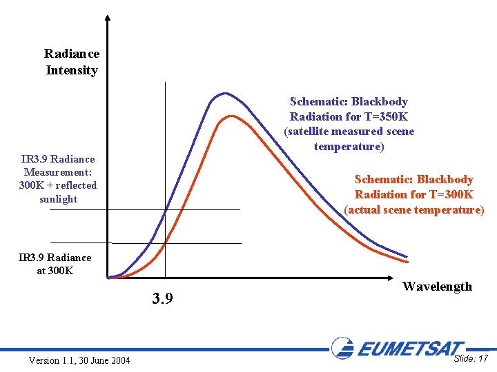
SEVIRI CHANNELS: IR 3. 9 m Signal in IR 3. 9 channel comes from reflected solar and emitted thermal radiation ! Consequence for Planck relation between radiance and temperature: during day-time, temperature is not representative of any in situ temperature (see next slide) ! Planck blackbody radiance curves Version 1. 1, 30 June 2004 Slide: 16

Radiance Intensity Schematic: Blackbody Radiation for T=350 K (satellite measured scene temperature) IR 3. 9 Radiance Measurement: 300 K + reflected sunlight Schematic: Blackbody Radiation for T=300 K (actual scene temperature) IR 3. 9 Radiance at 300 K 3. 9 Version 1. 1, 30 June 2004 Wavelength Slide: 17

3. 9 m Imagery Presentation Should IR 3. 9 be displayed as visible or infrared image ? • In the GOES IR 3. 9 Channel Tutorial, the 3. 9 um imagery is presented in terms of energy vs grey scale, i. e. cold clouds appear dark, warm surfaces appear light-to-bright • In order to better compare with the other IR channels, in this presentation the display as infrared image is preferred, i. e. cold clouds appear bright, warm surfaces appear dark Version 1. 1, 30 June 2004 Slide: 18

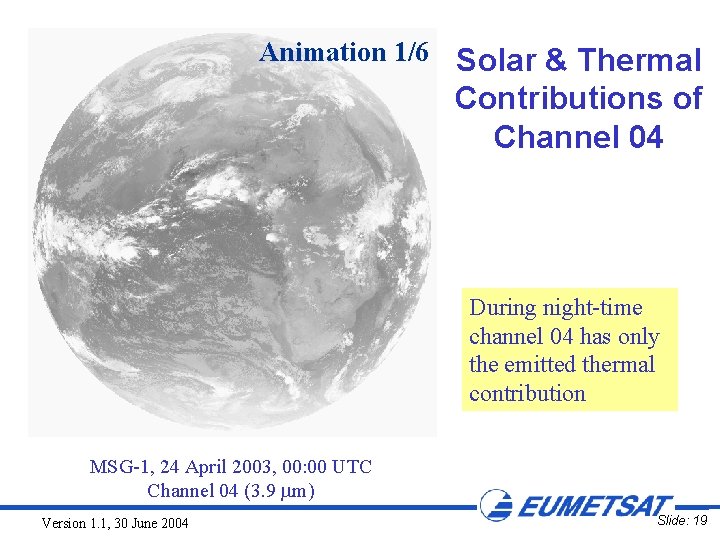
Animation 1/6 Solar & Thermal Contributions of Channel 04 During night-time channel 04 has only the emitted thermal contribution MSG-1, 24 April 2003, 00: 00 UTC Channel 04 (3. 9 m) Version 1. 1, 30 June 2004 Slide: 19

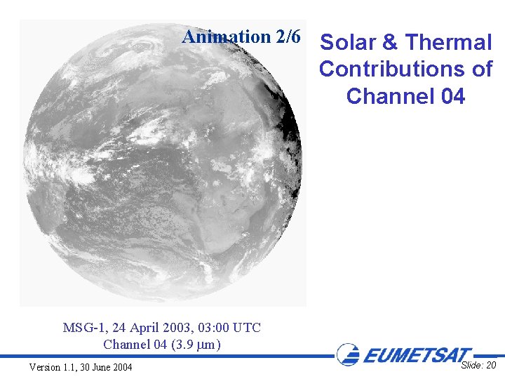
Animation 2/6 Solar & Thermal Contributions of Channel 04 MSG-1, 24 April 2003, 03: 00 UTC Channel 04 (3. 9 m) Version 1. 1, 30 June 2004 Slide: 20

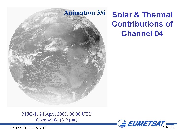
Animation 3/6 Solar & Thermal Contributions of Channel 04 MSG-1, 24 April 2003, 06: 00 UTC Channel 04 (3. 9 m) Version 1. 1, 30 June 2004 Slide: 21

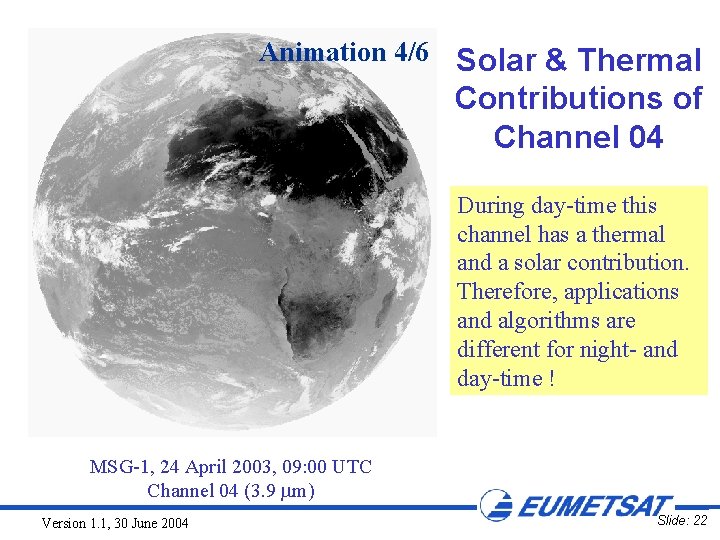
Animation 4/6 Solar & Thermal Contributions of Channel 04 During day-time this channel has a thermal and a solar contribution. Therefore, applications and algorithms are different for night- and day-time ! MSG-1, 24 April 2003, 09: 00 UTC Channel 04 (3. 9 m) Version 1. 1, 30 June 2004 Slide: 22

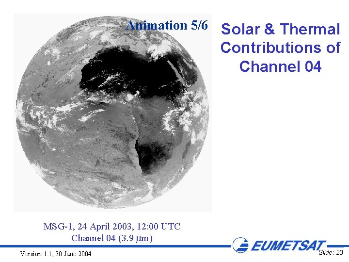
Animation 5/6 Solar & Thermal Contributions of Channel 04 MSG-1, 24 April 2003, 12: 00 UTC Channel 04 (3. 9 m) Version 1. 1, 30 June 2004 Slide: 23

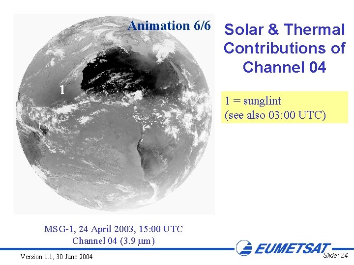
Animation 6/6 Solar & Thermal Contributions of Channel 04 1 1 = sunglint (see also 03: 00 UTC) MSG-1, 24 April 2003, 15: 00 UTC Channel 04 (3. 9 m) Version 1. 1, 30 June 2004 Slide: 24

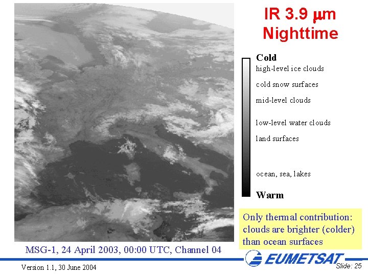
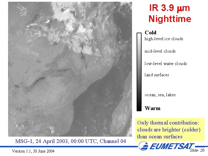
IR 3. 9 m Nighttime Cold high-level ice clouds cold snow surfaces mid-level clouds low-level water clouds land surfaces ocean, sea, lakes Warm MSG-1, 24 April 2003, 00: 00 UTC, Channel 04 Version 1. 1, 30 June 2004 Only thermal contribution: clouds are brighter (colder) than ocean surfaces Slide: 25

IR 3. 9 m Nighttime Cold high-level ice clouds mid-level clouds low-level water clouds land surfaces ocean, sea, lakes Warm MSG-1, 24 April 2003, 00: 00 UTC, Channel 04 Version 1. 1, 30 June 2004 Only thermal contribution: clouds are brighter (colder) than ocean surfaces Slide: 26

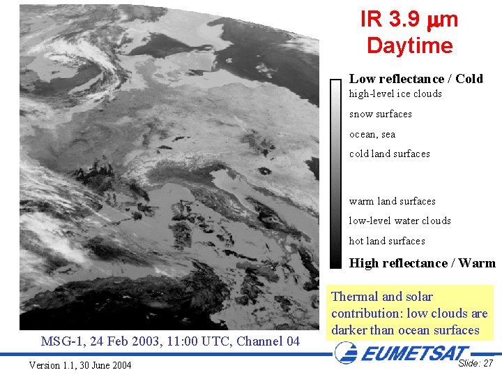
IR 3. 9 m Daytime Low reflectance / Cold high-level ice clouds snow surfaces ocean, sea cold land surfaces warm land surfaces low-level water clouds hot land surfaces High reflectance / Warm MSG-1, 24 Feb 2003, 11: 00 UTC, Channel 04 Version 1. 1, 30 June 2004 Thermal and solar contribution: low clouds are darker than ocean surfaces Slide: 27

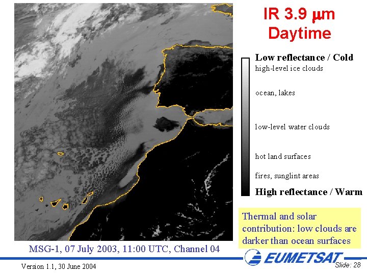
IR 3. 9 m Daytime Low reflectance / Cold high-level ice clouds ocean, lakes low-level water clouds hot land surfaces fires, sunglint areas High reflectance / Warm MSG-1, 07 July 2003, 11: 00 UTC, Channel 04 Version 1. 1, 30 June 2004 Thermal and solar contribution: low clouds are darker than ocean surfaces Slide: 28

IR 3. 9: INFLUENCE OF SURFACE EMISSIVITY Version 1. 1, 30 June 2004 Slide: 29

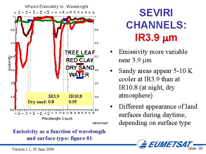
SEVIRI CHANNELS: IR 3. 9 m • Emissivity more variable near 3. 9 m IR 3. 9 Dry sand: 0. 8 IR 10. 8 0. 95 • Sandy areas appear 5 -10 K cooler at IR 3. 9 than at IR 10. 8 (at night, dry atmosphere) • Different appearance of land surfaces during daytime, depending on surface type Emissivity as a function of wavelength and surface type: figure 01 Version 1. 1, 30 June 2004 Slide: 30

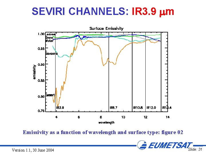
SEVIRI CHANNELS: IR 3. 9 m Emissivity as a function of wavelength and surface type: figure 02 Version 1. 1, 30 June 2004 Slide: 31

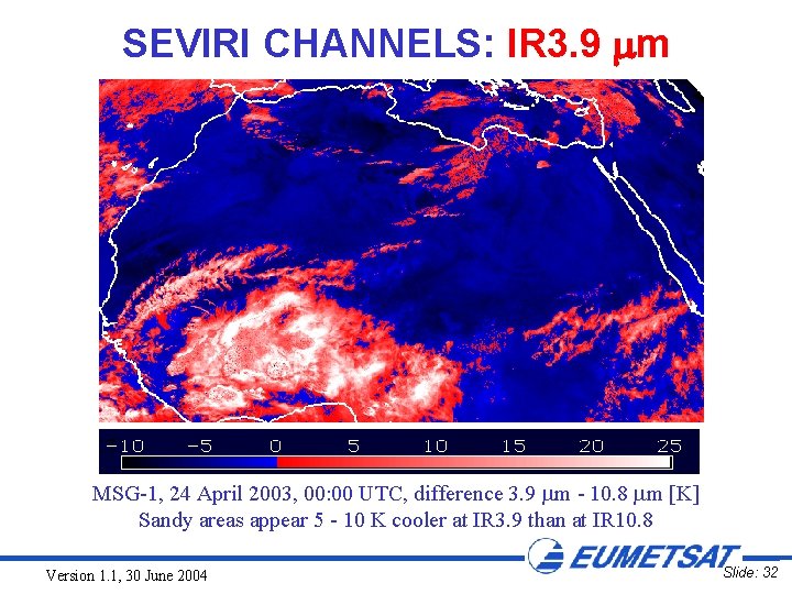
SEVIRI CHANNELS: IR 3. 9 m MSG-1, 24 April 2003, 00: 00 UTC, difference 3. 9 m - 10. 8 m [K] Sandy areas appear 5 - 10 K cooler at IR 3. 9 than at IR 10. 8 Version 1. 1, 30 June 2004 Slide: 32

IR 3. 9: APPLICATIONS Version 1. 1, 30 June 2004 Slide: 33

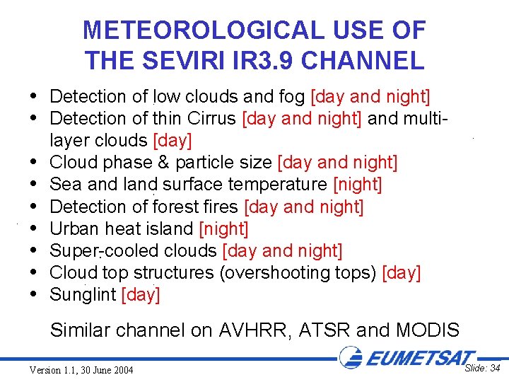
METEOROLOGICAL USE OF THE SEVIRI IR 3. 9 CHANNEL Detection of low clouds and fog [day and night] Detection of thin Cirrus [day and night] and multilayer clouds [day] Cloud phase & particle size [day and night] Sea and land surface temperature [night] Detection of forest fires [day and night] Urban heat island [night] Super-cooled clouds [day and night] Cloud top structures (overshooting tops) [day] Sunglint [day] Similar channel on AVHRR, ATSR and MODIS Version 1. 1, 30 June 2004 Slide: 34

IR 3. 9: DETECTION OF FOG / LOW STRATUS (DAY AND NIGHT-TIME) Version 1. 1, 30 June 2004 Slide: 35

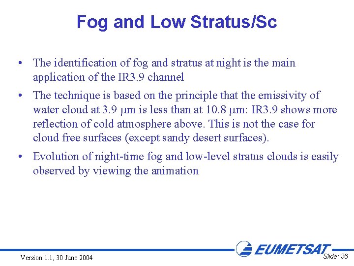
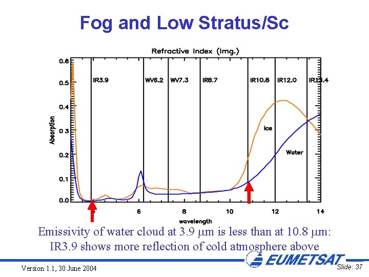
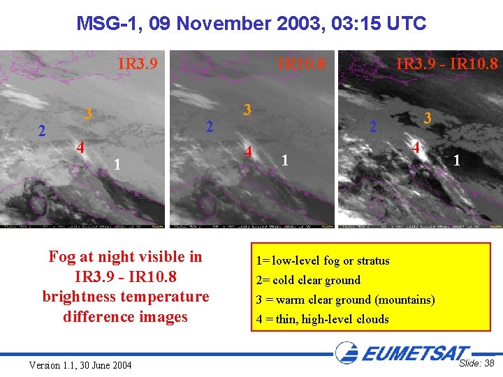
Fog and Low Stratus/Sc • The identification of fog and stratus at night is the main application of the IR 3. 9 channel • The technique is based on the principle that the emissivity of water cloud at 3. 9 m is less than at 10. 8 m: IR 3. 9 shows more reflection of cold atmosphere above. This is not the case for cloud free surfaces (except sandy desert surfaces). • Evolution of night-time fog and low-level stratus clouds is easily observed by viewing the animation Version 1. 1, 30 June 2004 Slide: 36

Fog and Low Stratus/Sc Emissivity of water cloud at 3. 9 m is less than at 10. 8 m: IR 3. 9 shows more reflection of cold atmosphere above Version 1. 1, 30 June 2004 Slide: 37

MSG-1, 09 November 2003, 03: 15 UTC IR 3. 9 2 3 4 IR 10. 8 2 1 Fog at night visible in IR 3. 9 - IR 10. 8 brightness temperature difference images Version 1. 1, 30 June 2004 3 4 IR 3. 9 - IR 10. 8 3 2 1 4 1 1= low-level fog or stratus 2= cold clear ground 3 = warm clear ground (mountains) 4 = thin, high-level clouds Slide: 38

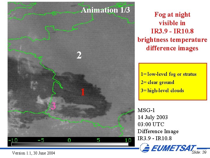
Animation 1/3 2 Fog at night visible in IR 3. 9 - IR 10. 8 brightness temperature difference images 1= low-level fog or stratus 2= clear ground 1 3 Version 1. 1, 30 June 2004 3= high-level clouds MSG-1 14 July 2003 03: 00 UTC Difference Image IR 3. 9 - IR 10. 8 Slide: 39

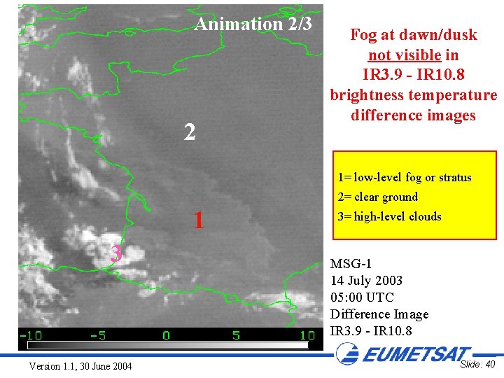
Animation 2/3 2 Fog at dawn/dusk not visible in IR 3. 9 - IR 10. 8 brightness temperature difference images 1= low-level fog or stratus 2= clear ground 1 3 Version 1. 1, 30 June 2004 3= high-level clouds MSG-1 14 July 2003 05: 00 UTC Difference Image IR 3. 9 - IR 10. 8 Slide: 40

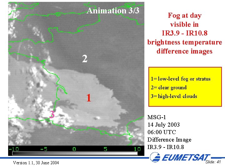
Animation 3/3 2 Fog at day visible in IR 3. 9 - IR 10. 8 brightness temperature difference images 1= low-level fog or stratus 2= clear ground 1 3 Version 1. 1, 30 June 2004 3= high-level clouds MSG-1 14 July 2003 06: 00 UTC Difference Image IR 3. 9 - IR 10. 8 Slide: 41

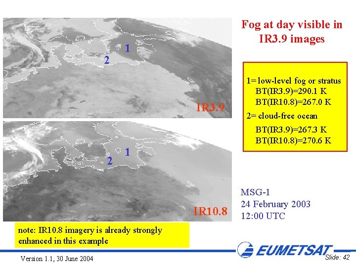
2 Fog at day visible in IR 3. 9 images 1 IR 3. 9 2 1= low-level fog or stratus BT(IR 3. 9)=290. 1 K BT(IR 10. 8)=267. 0 K 2= cloud-free ocean BT(IR 3. 9)=267. 3 K BT(IR 10. 8)=270. 6 K 1 IR 10. 8 MSG-1 24 February 2003 12: 00 UTC note: IR 10. 8 imagery is already strongly enhanced in this example Version 1. 1, 30 June 2004 Slide: 42

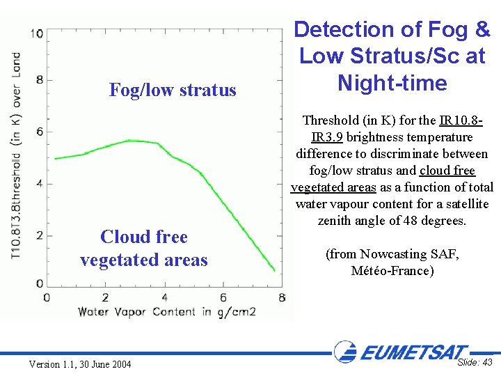
Fog/low stratus Cloud free vegetated areas Version 1. 1, 30 June 2004 Detection of Fog & Low Stratus/Sc at Night-time Threshold (in K) for the IR 10. 8 IR 3. 9 brightness temperature difference to discriminate between fog/low stratus and cloud free vegetated areas as a function of total water vapour content for a satellite zenith angle of 48 degrees. (from Nowcasting SAF, Météo-France) Slide: 43

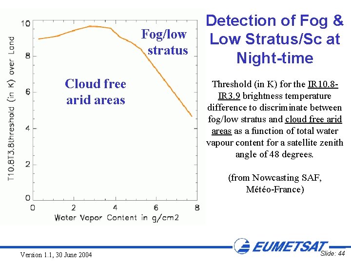
Fog/low stratus Cloud free arid areas Detection of Fog & Low Stratus/Sc at Night-time Threshold (in K) for the IR 10. 8 IR 3. 9 brightness temperature difference to discriminate between fog/low stratus and cloud free arid areas as a function of total water vapour content for a satellite zenith angle of 48 degrees. (from Nowcasting SAF, Météo-France) Version 1. 1, 30 June 2004 Slide: 44

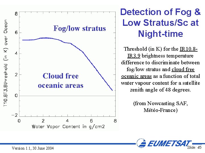
Fog/low stratus Cloud free oceanic areas Detection of Fog & Low Stratus/Sc at Night-time Threshold (in K) for the IR 10. 8 IR 3. 9 brightness temperature difference to discriminate between fog/low stratus and cloud free oceanic areas as a function of total water vapour content for a satellite zenith angle of 48 degrees. (from Nowcasting SAF, Météo-France) Version 1. 1, 30 June 2004 Slide: 45

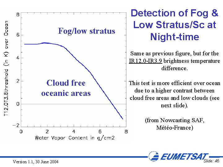
Fog/low stratus Detection of Fog & Low Stratus/Sc at Night-time Same as previous figure, but for the IR 12. 0 -IR 3. 9 brightness temperature difference. Cloud free oceanic areas This test is more efficient over ocean due to a higher contrast between cloud free areas and low clouds (see next slide). (from Nowcasting SAF, Météo-France) Version 1. 1, 30 June 2004 Slide: 46

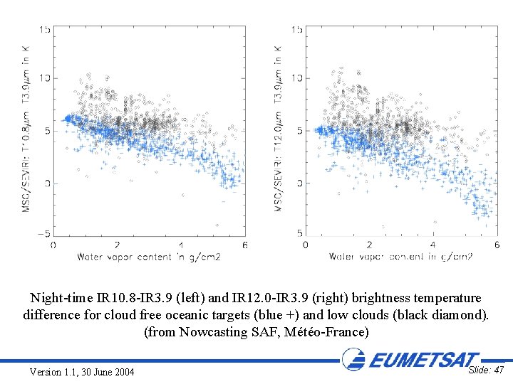
Night-time IR 10. 8 -IR 3. 9 (left) and IR 12. 0 -IR 3. 9 (right) brightness temperature difference for cloud free oceanic targets (blue +) and low clouds (black diamond). (from Nowcasting SAF, Météo-France) Version 1. 1, 30 June 2004 Slide: 47

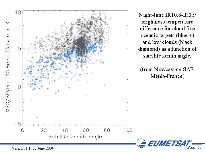
Night-time IR 10. 8 -IR 3. 9 brightness temperature difference for cloud free oceanic targets (blue +) and low clouds (black diamond) as a function of satellite zenith angle. (from Nowcasting SAF, Météo-France) Version 1. 1, 30 June 2004 Slide: 48

IR 3. 9: CLOUD PHASE AND PARTICLE SIZE (MAINLY DAY-TIME) Version 1. 1, 30 June 2004 Slide: 49

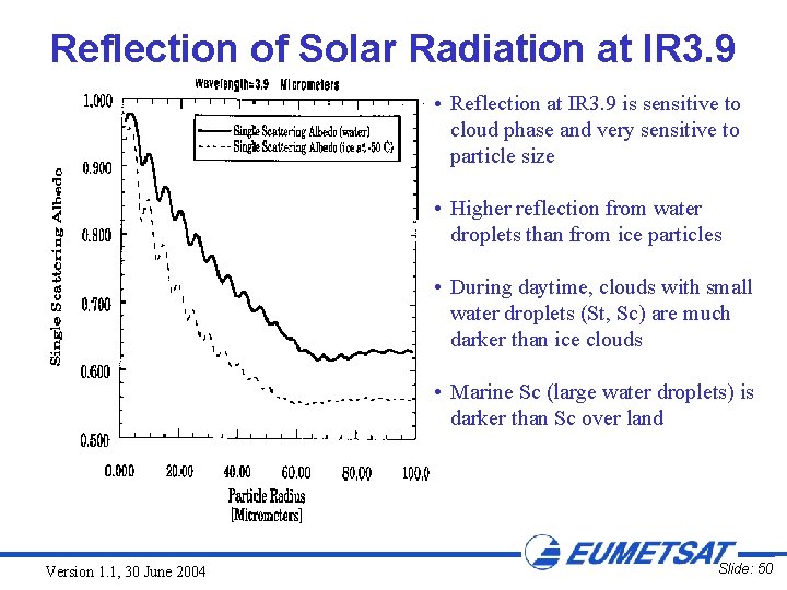
Reflection of Solar Radiation at IR 3. 9 • Reflection at IR 3. 9 is sensitive to cloud phase and very sensitive to particle size • Higher reflection from water droplets than from ice particles • During daytime, clouds with small water droplets (St, Sc) are much darker than ice clouds • Marine Sc (large water droplets) is darker than Sc over land Version 1. 1, 30 June 2004 Slide: 50

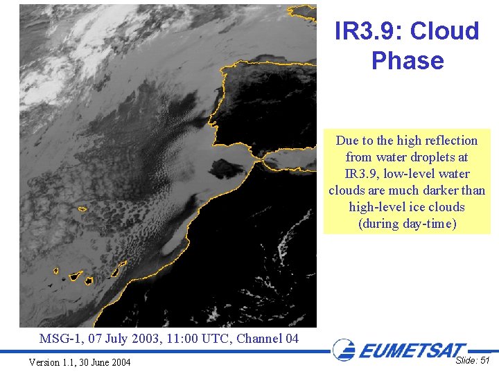
IR 3. 9: Cloud Phase Due to the high reflection from water droplets at IR 3. 9, low-level water clouds are much darker than high-level ice clouds (during day-time) MSG-1, 07 July 2003, 11: 00 UTC, Channel 04 Version 1. 1, 30 June 2004 Slide: 51

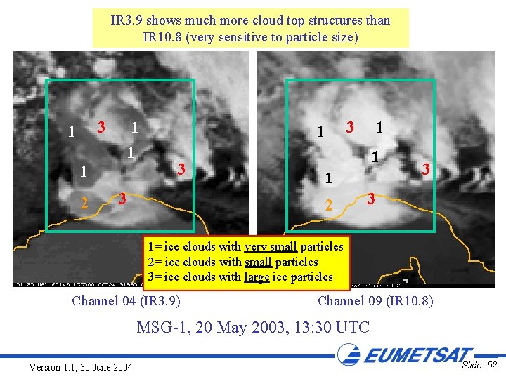
IR 3. 9 shows much more cloud top structures than IR 10. 8 (very sensitive to particle size) IR 3. 9: Cloud Particle Size 3 1 1 2 1 3 3 3 1 1 1 2 3 3 1= ice clouds with very small particles 2= ice clouds with small particles 3= ice clouds with large ice particles Channel 04 (IR 3. 9) Channel 09 (IR 10. 8) MSG-1, 20 May 2003, 13: 30 UTC Version 1. 1, 30 June 2004 Slide: 52

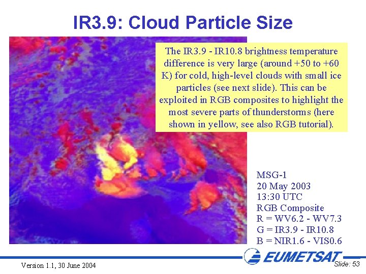
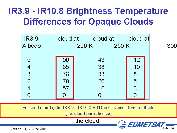
IR 3. 9: Cloud Particle Size The IR 3. 9 - IR 10. 8 brightness temperature difference is very large (around +50 to +60 K) for cold, high-level clouds with small ice particles (see next slide). This can be exploited in RGB composites to highlight the most severe parts of thunderstorms (here shown in yellow, see also RGB tutorial). MSG-1 20 May 2003 13: 30 UTC RGB Composite R = WV 6. 2 - WV 7. 3 G = IR 3. 9 - IR 10. 8 B = NIR 1. 6 - VIS 0. 6 Version 1. 1, 30 June 2004 Slide: 53

IR 3. 9 - IR 10. 8 Brightness Temperature Differences for Opaque Clouds IR 3. 9 Albedo 5 4 3 2 1 0 cloud at 200 K 250 K 90 85 78 70 57 0 43 38 33 26 16 0 300 12 10 8 5 3 0 IR 3. 9 IR 10. 8 brightness temperature difference K) for For- cold clouds, the IR 3. 9 - IR 10. 8 BTD is very sensitive to (in albedo particle size) different temperatures of(i. e. thecloud assuming little humidity above the cloud. Version 1. 1, 30 June 2004 Slide: 54

IR 3. 9: DETECTION OF THIN CIRRUS CLOUDS (DAY AND NIGHT-TIME) Version 1. 1, 30 June 2004 Slide: 55

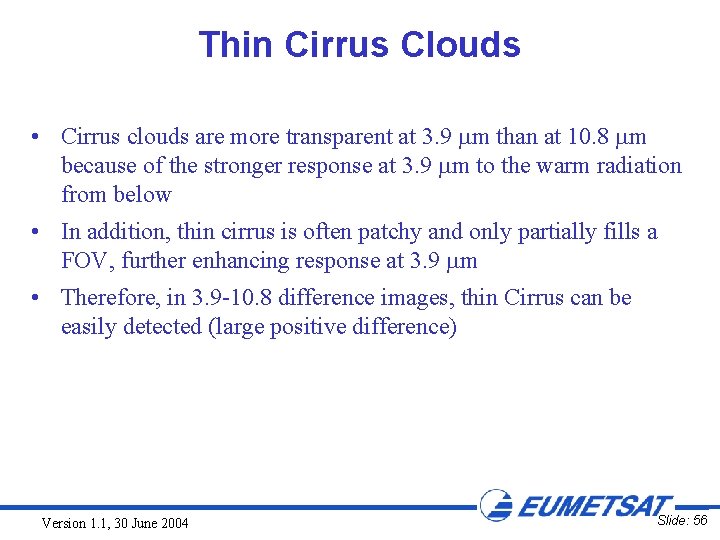
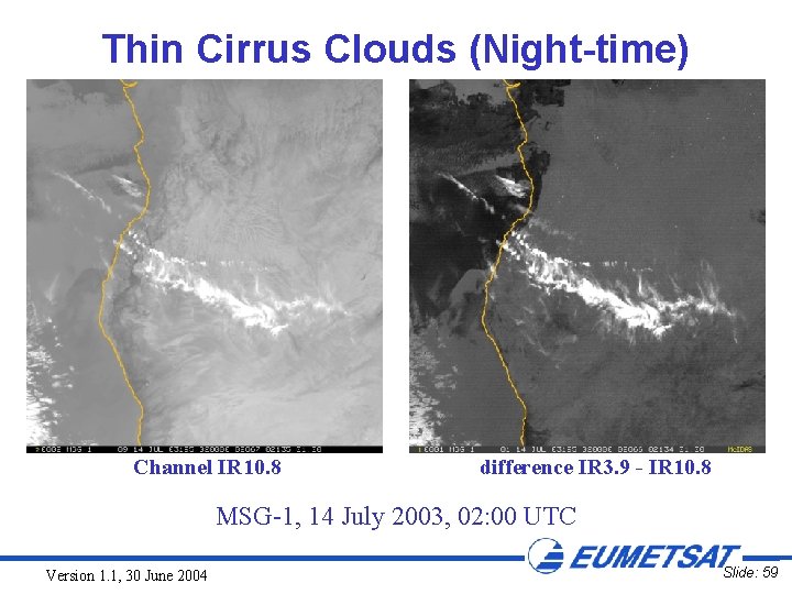
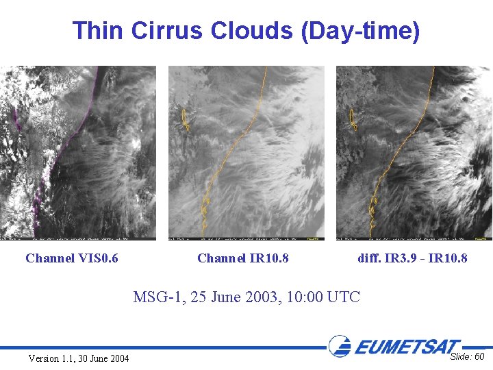
Thin Cirrus Clouds • Cirrus clouds are more transparent at 3. 9 m than at 10. 8 m because of the stronger response at 3. 9 m to the warm radiation from below • In addition, thin cirrus is often patchy and only partially fills a FOV, further enhancing response at 3. 9 m • Therefore, in 3. 9 -10. 8 difference images, thin Cirrus can be easily detected (large positive difference) Version 1. 1, 30 June 2004 Slide: 56

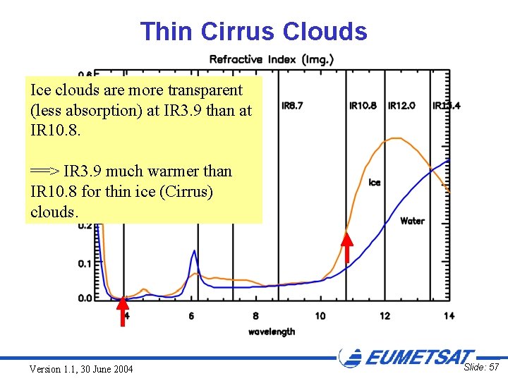
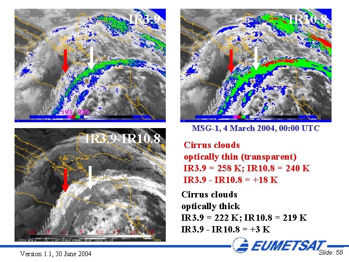
Thin Cirrus Clouds Ice clouds are more transparent (less absorption) at IR 3. 9 than at IR 10. 8. ==> IR 3. 9 much warmer than IR 10. 8 for thin ice (Cirrus) clouds. Version 1. 1, 30 June 2004 Slide: 57

IR 3. 9 -IR 10. 8 MSG-1, 4 March 2004, 00: 00 UTC Cirrus clouds optically thin (transparent) IR 3. 9 = 258 K; IR 10. 8 = 240 K IR 3. 9 - IR 10. 8 = +18 K Cirrus clouds optically thick IR 3. 9 = 222 K; IR 10. 8 = 219 K IR 3. 9 - IR 10. 8 = +3 K Version 1. 1, 30 June 2004 Slide: 58

Thin Cirrus Clouds (Night-time) Channel IR 10. 8 difference IR 3. 9 - IR 10. 8 MSG-1, 14 July 2003, 02: 00 UTC Version 1. 1, 30 June 2004 Slide: 59

Thin Cirrus Clouds (Day-time) Channel VIS 0. 6 Channel IR 10. 8 diff. IR 3. 9 - IR 10. 8 MSG-1, 25 June 2003, 10: 00 UTC Version 1. 1, 30 June 2004 Slide: 60

IR 3. 9: DETECTION OF MULTI-LAYER CLOUDS (DAY-TIME) Version 1. 1, 30 June 2004 Slide: 61

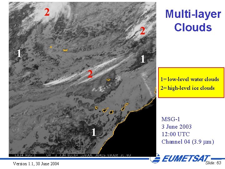
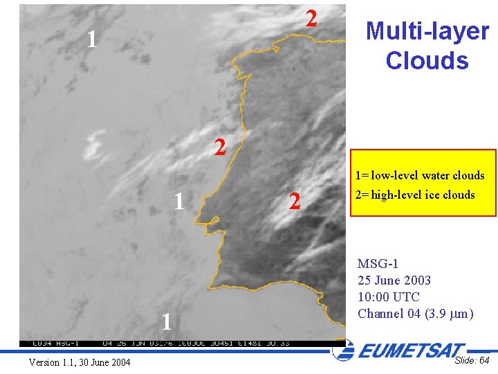
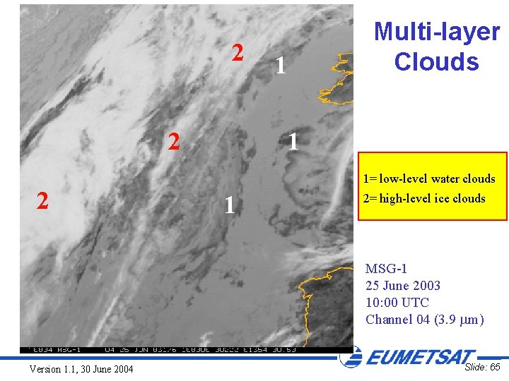
Multi-layer Clouds • During daytime, low-level water clouds, with their higher reflectivity, appear much darker ("warmer") than high-level ice clouds • Low-level water clouds can easily be detected at 3. 9 um, even below Cirrus clouds Version 1. 1, 30 June 2004 Slide: 62

2 2 1 Multi-layer Clouds 1 2 1= low-level water clouds 2= high-level ice clouds 1 Version 1. 1, 30 June 2004 MSG-1 3 June 2003 12: 00 UTC Channel 04 (3. 9 m) Slide: 63

2 1 Multi-layer Clouds 2 1= low-level water clouds 1 1 Version 1. 1, 30 June 2004 2 2= high-level ice clouds MSG-1 25 June 2003 10: 00 UTC Channel 04 (3. 9 m) Slide: 64

2 2 Multi-layer Clouds 1 1 1= low-level water clouds 2 1 2= high-level ice clouds MSG-1 25 June 2003 10: 00 UTC Channel 04 (3. 9 m) Version 1. 1, 30 June 2004 Slide: 65

IR 3. 9: DETECTION OF SUPERCOOLED CLOUDS (DAY AND NIGHT-TIME) Version 1. 1, 30 June 2004 Slide: 66

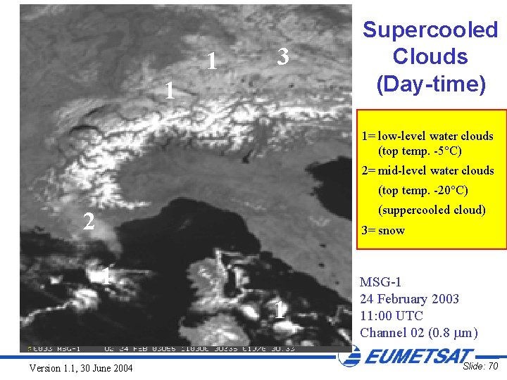
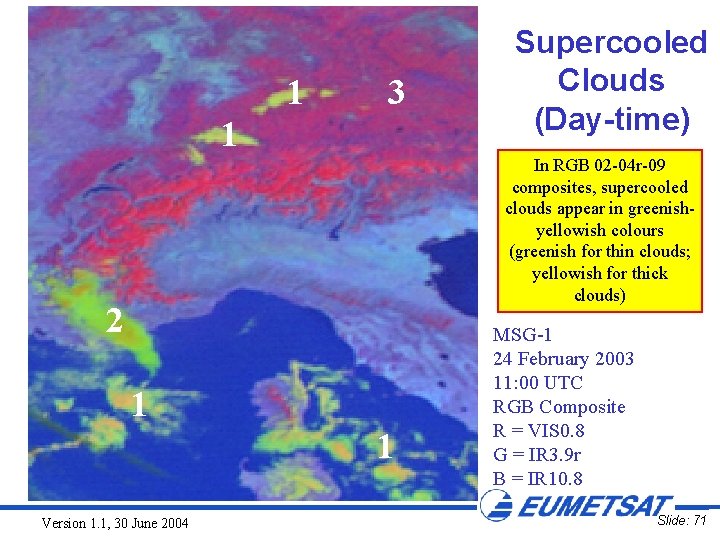
Supercooled Clouds (Day-time) • Cloud tops consisting of supercooled water droplets may be located by using: – the 3. 9 m imagery to identify phase: supercooled water clouds have high reflection and appear dark. – the 10. 8 m imagery to determine cloud top temperature: supercooled water clouds have a top temperature between 0°C and -40°C. Version 1. 1, 30 June 2004 Slide: 67

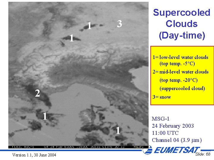
1 3 1 Supercooled Clouds (Day-time) 1= low-level water clouds (top temp. -5°C) 2= mid-level water clouds (top temp. -20°C) (suppercooled cloud) 2 3= snow 1 1 Version 1. 1, 30 June 2004 MSG-1 24 February 2003 11: 00 UTC Channel 04 (3. 9 m) Slide: 68

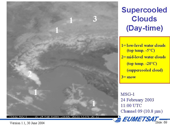
1 3 1 Supercooled Clouds (Day-time) 1= low-level water clouds (top temp. -5°C) 2= mid-level water clouds (top temp. -20°C) (suppercooled cloud) 2 3= snow 1 1 Version 1. 1, 30 June 2004 MSG-1 24 February 2003 11: 00 UTC Channel 09 (10. 8 m) Slide: 69

1 3 1 Supercooled Clouds (Day-time) 1= low-level water clouds (top temp. -5°C) 2= mid-level water clouds (top temp. -20°C) (suppercooled cloud) 2 3= snow 1 1 Version 1. 1, 30 June 2004 MSG-1 24 February 2003 11: 00 UTC Channel 02 (0. 8 m) Slide: 70

1 3 1 Supercooled Clouds (Day-time) In RGB 02 -04 r-09 composites, supercooled clouds appear in greenishyellowish colours (greenish for thin clouds; yellowish for thick clouds) 2 1 1 Version 1. 1, 30 June 2004 MSG-1 24 February 2003 11: 00 UTC RGB Composite R = VIS 0. 8 G = IR 3. 9 r B = IR 10. 8 Slide: 71

Supercooled Clouds (Nighttime) • During the night-time hours, water clouds can also be distinguished from ice clouds by using the "fog product" (difference IR 3. 9 - IR 10. 8). • Similar to the day-time application, the "fog product" and the 10. 8 m imagery can be used together to locate cloud tops consisting of supercooled water at night. Version 1. 1, 30 June 2004 Slide: 72

IR 3. 9: SUN GLINT (DAY-TIME) Version 1. 1, 30 June 2004 Slide: 73

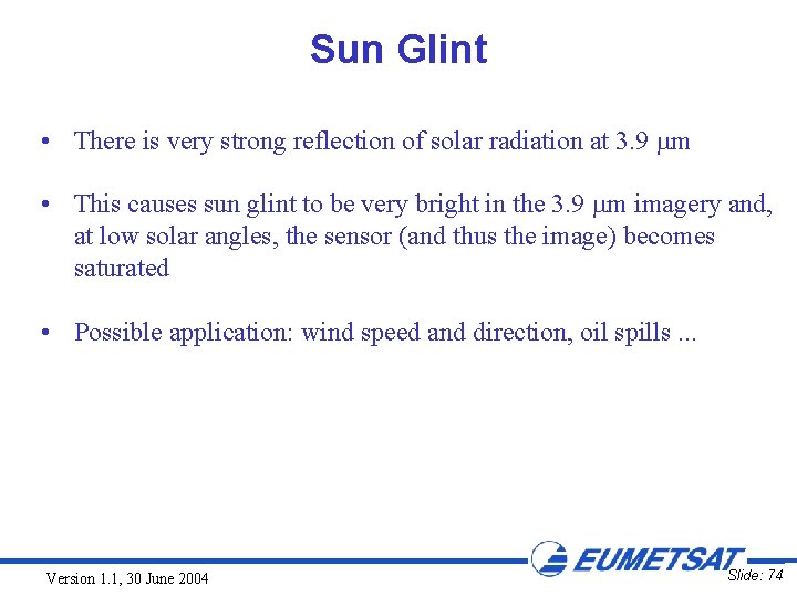
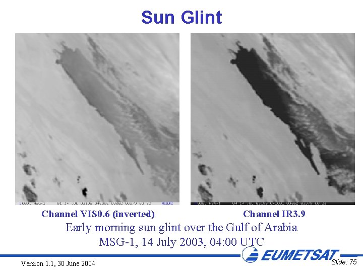
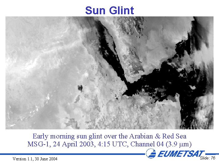
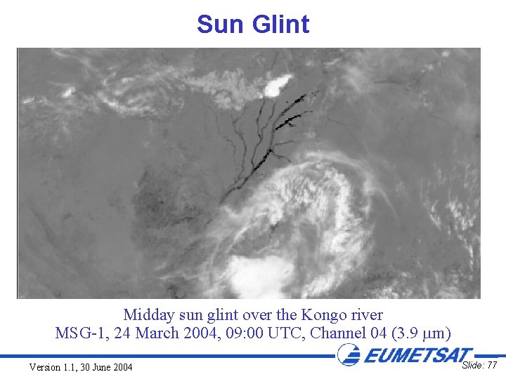
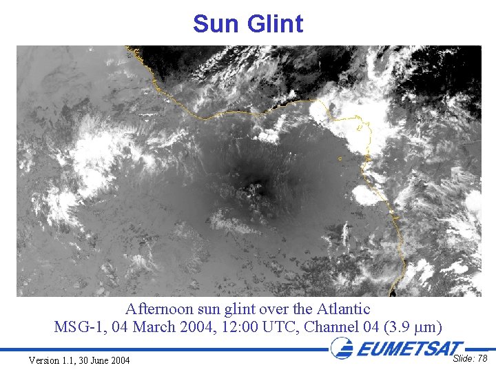
Sun Glint • There is very strong reflection of solar radiation at 3. 9 m • This causes sun glint to be very bright in the 3. 9 m imagery and, at low solar angles, the sensor (and thus the image) becomes saturated • Possible application: wind speed and direction, oil spills. . . Version 1. 1, 30 June 2004 Slide: 74

Sun Glint Channel VIS 0. 6 (inverted) Channel IR 3. 9 Early morning sun glint over the Gulf of Arabia MSG-1, 14 July 2003, 04: 00 UTC Version 1. 1, 30 June 2004 Slide: 75

Sun Glint Early morning sun glint over the Arabian & Red Sea MSG-1, 24 April 2003, 4: 15 UTC, Channel 04 (3. 9 m) Version 1. 1, 30 June 2004 Slide: 76

Sun Glint Midday sun glint over the Kongo river MSG-1, 24 March 2004, 09: 00 UTC, Channel 04 (3. 9 m) Version 1. 1, 30 June 2004 Slide: 77

Sun Glint Afternoon sun glint over the Atlantic MSG-1, 04 March 2004, 12: 00 UTC, Channel 04 (3. 9 m) Version 1. 1, 30 June 2004 Slide: 78

SUB-PIXEL RESPONSE OF IR 3. 9 CHANNEL Version 1. 1, 30 June 2004 Slide: 79

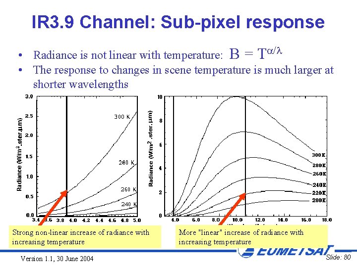
IR 3. 9 Channel: Sub-pixel response • Radiance is not linear with temperature: B = T / • The response to changes in scene temperature is much larger at shorter wavelengths Strong non-linear increase of radiance with increasing temperature Version 1. 1, 30 June 2004 More "linear" increase of radiance with increasing temperature Slide: 80

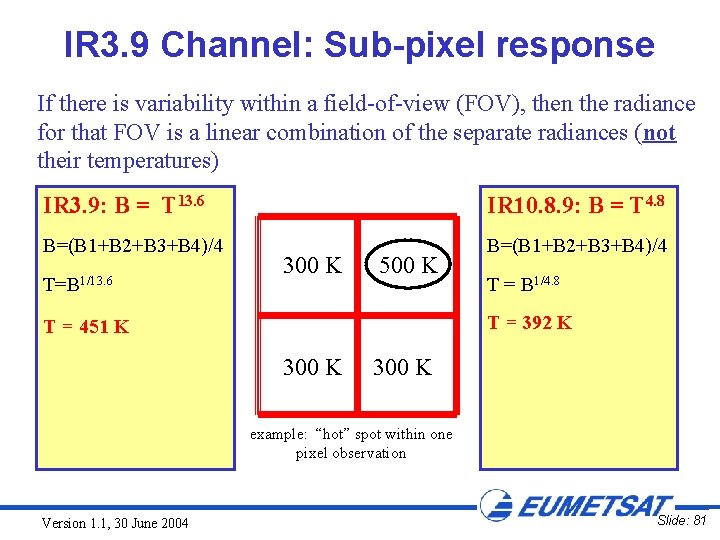
IR 3. 9 Channel: Sub-pixel response If there is variability within a field-of-view (FOV), then the radiance for that FOV is a linear combination of the separate radiances (not their temperatures) IR 3. 9: B = T 13. 6 IR 10. 8. 9: B = T 4. 8 B=(B 1+B 2+B 3+B 4)/4 T=B 1/13. 6 300 K 500 K T = B 1/4. 8 T = 392 K T = 451 K 300 K example: “hot” spot within one pixel observation Version 1. 1, 30 June 2004 Slide: 81

IR 3. 9: DETECTION OF (FOREST) FIRES (DAY AND NIGHT-TIME) Version 1. 1, 30 June 2004 Slide: 82

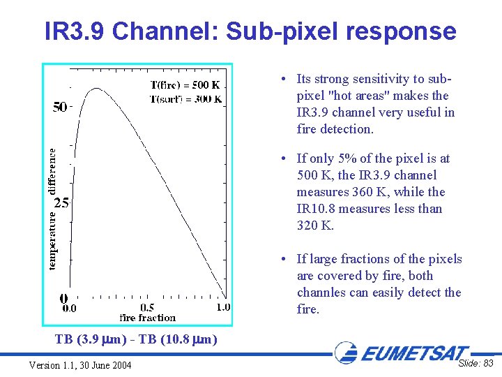
IR 3. 9 Channel: Sub-pixel response • Its strong sensitivity to subpixel "hot areas" makes the IR 3. 9 channel very useful in fire detection. • If only 5% of the pixel is at 500 K, the IR 3. 9 channel measures 360 K, while the IR 10. 8 measures less than 320 K. • If large fractions of the pixels are covered by fire, both channles can easily detect the fire. TB (3. 9 m) - TB (10. 8 m) Version 1. 1, 30 June 2004 Slide: 83

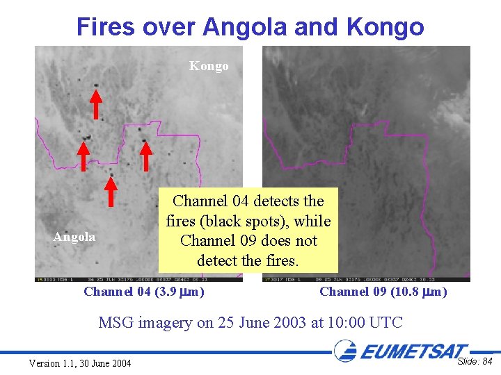
Fires over Angola and Kongo Channel 04 detects the fires (black spots), while Channel 09 does not detect the fires. Angola Channel 04 (3. 9 m) Channel 09 (10. 8 m) MSG imagery on 25 June 2003 at 10: 00 UTC Version 1. 1, 30 June 2004 Slide: 84

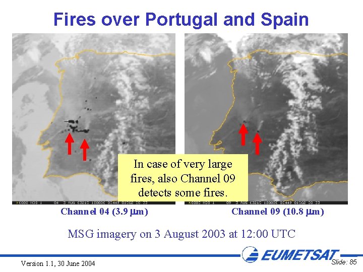
Fires over Portugal and Spain In case of very large fires, also Channel 09 detects some fires. Channel 04 (3. 9 m) Channel 09 (10. 8 m) MSG imagery on 3 August 2003 at 12: 00 UTC Version 1. 1, 30 June 2004 Slide: 85

IR 3. 9: DETECTION OF BROKEN CLOUDS (DAY AND NIGHT-TIME) Version 1. 1, 30 June 2004 Slide: 86

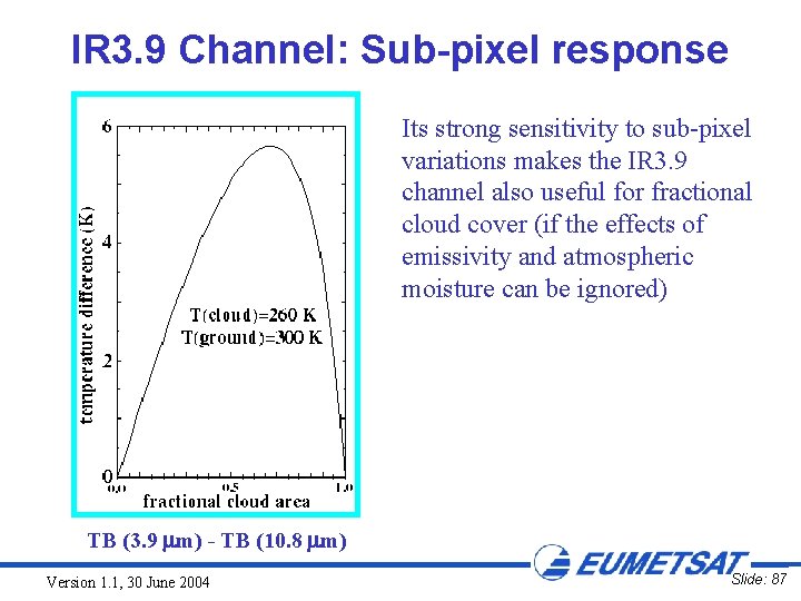
IR 3. 9 Channel: Sub-pixel response Its strong sensitivity to sub-pixel variations makes the IR 3. 9 channel also useful for fractional cloud cover (if the effects of emissivity and atmospheric moisture can be ignored) TB (3. 9 m) - TB (10. 8 m) Version 1. 1, 30 June 2004 Slide: 87

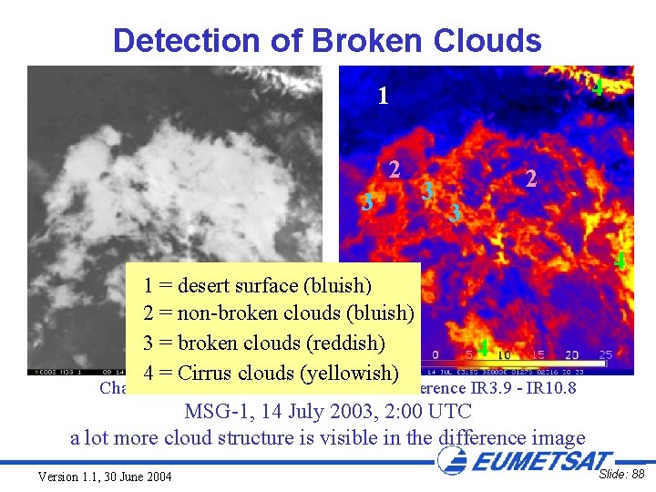
Detection of Broken Clouds 4 1 2 3 1 = desert surface (bluish) 2 = non-broken clouds (bluish) 3 = broken clouds (reddish) 4 = Cirrus clouds (yellowish) Channel IR 10. 8 3 2 3 4 4 difference IR 3. 9 - IR 10. 8 MSG-1, 14 July 2003, 2: 00 UTC a lot more cloud structure is visible in the difference image Version 1. 1, 30 June 2004 Slide: 88

IR 3. 9: DETECTION OF URBAN HEAT "ISLANDS" (DAY-TIME) Version 1. 1, 30 June 2004 Slide: 89

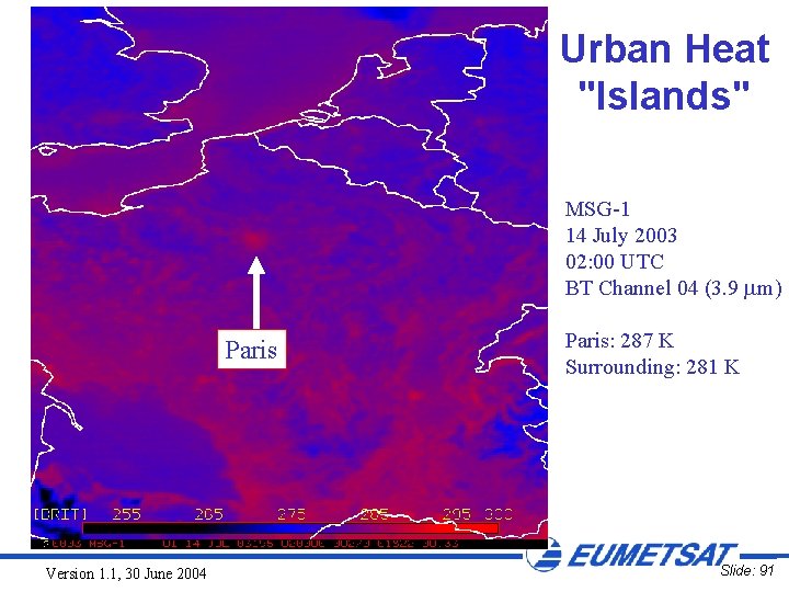
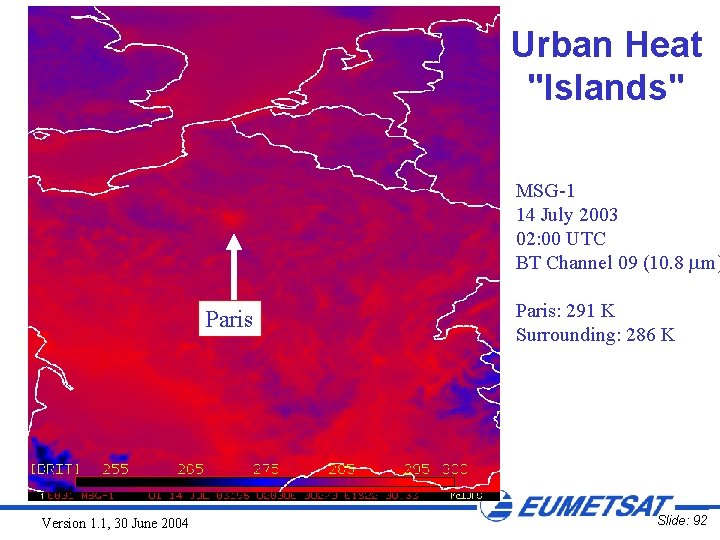
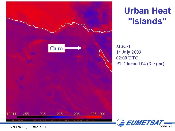
Urban Heat "Islands" • MSG IR imagery makes it possible to locate urban heat "islands" under clear sky conditions • The IR 3. 9 channel is better than IR 10. 8 better because of high sensitivity to sub-pixel temperature variations (warm areas in cities are like little fires) • Stronger signal (temperature difference city - surroundings) in IR 3. 9 than in the other IR channels Version 1. 1, 30 June 2004 Slide: 90

Urban Heat "Islands" MSG-1 14 July 2003 02: 00 UTC BT Channel 04 (3. 9 m) Paris Version 1. 1, 30 June 2004 Paris: 287 K Surrounding: 281 K Slide: 91

Urban Heat "Islands" MSG-1 14 July 2003 02: 00 UTC BT Channel 09 (10. 8 m) Paris Version 1. 1, 30 June 2004 Paris: 291 K Surrounding: 286 K Slide: 92

Urban Heat "Islands" Cairo Version 1. 1, 30 June 2004 MSG-1 14 July 2003 02: 00 UTC BT Channel 04 (3. 9 m) Slide: 93

NOISE IN THE IR 3. 9 CHANNEL Version 1. 1, 30 June 2004 Slide: 94

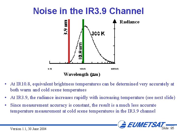
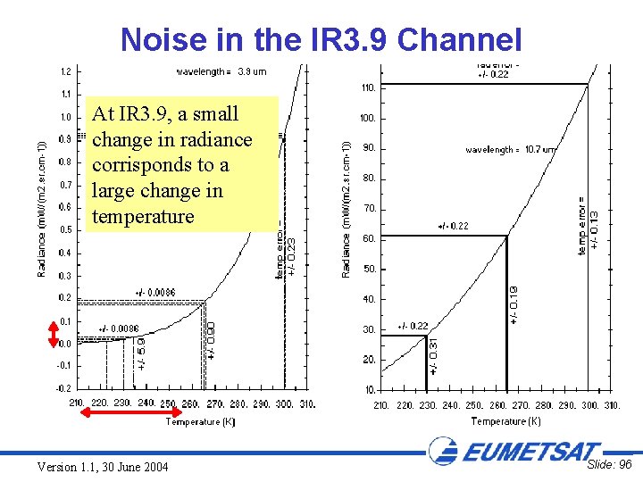
Noise in the IR 3. 9 Channel Radiance Wavelength ( m) • At IR 10. 8, equivalent brightness temperatures can be determined very accurately at both warm and cold scene temperatues • At IR 3. 9, the radiance increases rapidly with increasing temperature (see next slide) • Since measurement accuracy is constant, the result is a much less accurate temperature measurement at cold scene temperatures in the IR 3. 9 channel Version 1. 1, 30 June 2004 Slide: 95

Noise in the IR 3. 9 Channel At IR 3. 9, a small change in radiance corrisponds to a large change in temperature Version 1. 1, 30 June 2004 Slide: 96

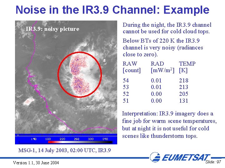
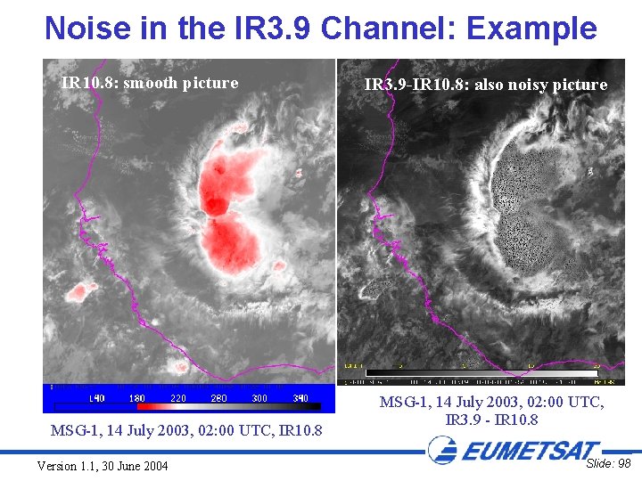
Noise in the IR 3. 9 Channel: Example IR 3. 9: noisy picture During the night, the IR 3. 9 channel cannot be used for cold cloud tops. Below BTs of 220 K the IR 3. 9 channel is very noisy (radiances close to zero). RAW [count] RAD TEMP [m. W/m 2] [K] 54 53 52 51 0. 01 0. 00 218 213 205 131 Interpretation: IR 3. 9 imagery does a fine job for warm scene temperatures, but at night it is not useful for cold scenes like thunderstorm tops. MSG-1, 14 July 2003, 02: 00 UTC, IR 3. 9 Version 1. 1, 30 June 2004 Slide: 97

Noise in the IR 3. 9 Channel: Example IR 10. 8: smooth picture MSG-1, 14 July 2003, 02: 00 UTC, IR 10. 8 Version 1. 1, 30 June 2004 IR 3. 9 -IR 10. 8: also noisy picture MSG-1, 14 July 2003, 02: 00 UTC, IR 3. 9 - IR 10. 8 Slide: 98

SUMMARY Version 1. 1, 30 June 2004 Slide: 99

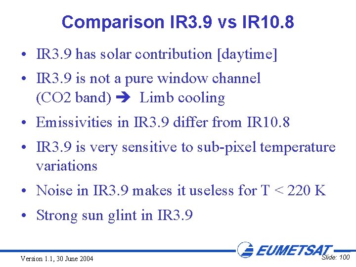
Comparison IR 3. 9 vs IR 10. 8 • IR 3. 9 has solar contribution [daytime] • IR 3. 9 is not a pure window channel (CO 2 band) Limb cooling • Emissivities in IR 3. 9 differ from IR 10. 8 • IR 3. 9 is very sensitive to sub-pixel temperature variations • Noise in IR 3. 9 makes it useless for T < 220 K • Strong sun glint in IR 3. 9 Version 1. 1, 30 June 2004 Slide: 100

http: //www. cira. colostate. edu/ramm/goes 39/cover. htm Version 1. 1, 30 June 2004 Slide: 101