APPLICATIONS OF METEOSAT SECOND GENERATION MSG FOG DETECTION


- Slides: 102

APPLICATIONS OF METEOSAT SECOND GENERATION (MSG) FOG DETECTION Author: Jochen Kerkmann (EUMETSAT) (kerkmann@eumetsat. de) Contributors: H. J. Lutz (EUMETSAT), P. Pylkkö (FMI), HP. Roesli (Meteo. Swiss), D. Rosenfeld (HUJ) Version 1. 0, 14 May 2004 Slide: 1

Day-time Fog over Southern Germany 24 February 2003 Version 1. 0, 14 May 2004 Slide: 2

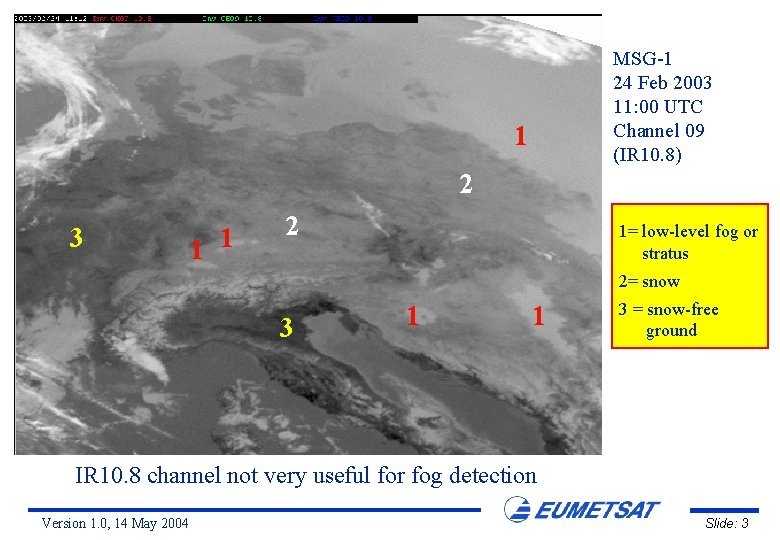
MSG-1 24 Feb 2003 11: 00 UTC Channel 09 (IR 10. 8) 1 2 3 1 1 2 1= low-level fog or stratus 2= snow 3 1 1 3 = snow-free ground IR 10. 8 channel not very useful for fog detection Version 1. 0, 14 May 2004 Slide: 3

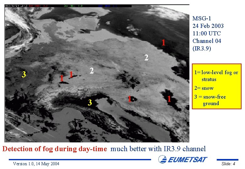
MSG-1 24 Feb 2003 11: 00 UTC Channel 04 (IR 3. 9) 1 2 3 1 1 2 1= low-level fog or stratus 2= snow 3 1 1 3 = snow-free ground Detection of fog during day-time much better with IR 3. 9 channel Version 1. 0, 14 May 2004 Slide: 4

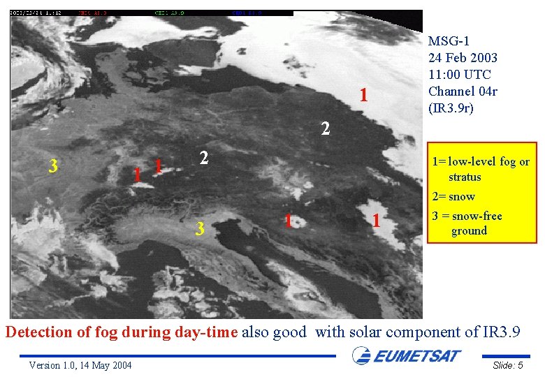
MSG-1 24 Feb 2003 11: 00 UTC Channel 04 r (IR 3. 9 r) 1 2 3 1 1 2 1= low-level fog or stratus 2= snow 3 1 1 3 = snow-free ground Detection of fog during day-time also good with solar component of IR 3. 9 Version 1. 0, 14 May 2004 Slide: 5

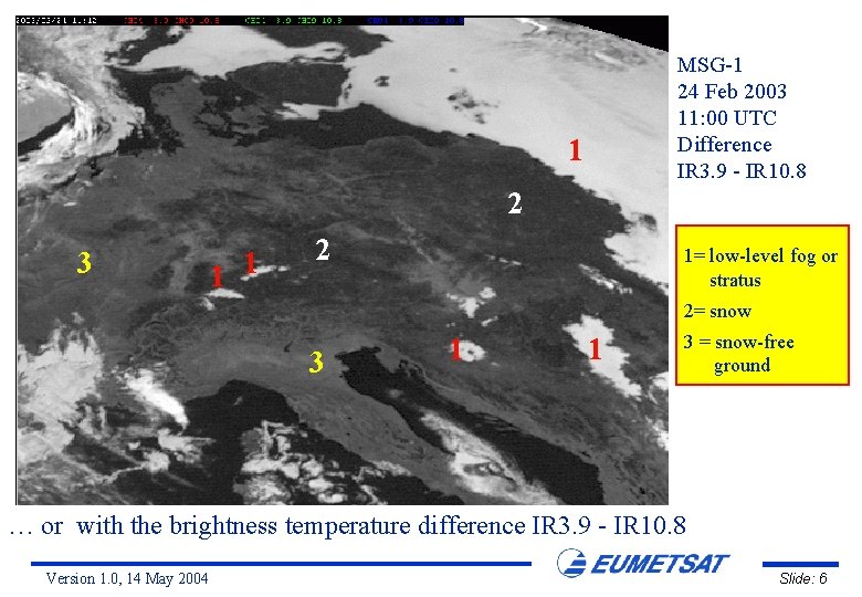
MSG-1 24 Feb 2003 11: 00 UTC Difference IR 3. 9 - IR 10. 8 1 2 3 1 1 2 1= low-level fog or stratus 2= snow 3 1 1 3 = snow-free ground … or with the brightness temperature difference IR 3. 9 - IR 10. 8 Version 1. 0, 14 May 2004 Slide: 6

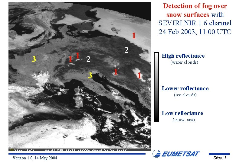
Detection of fog over snow surfaces with SEVIRI NIR 1. 6 channel 24 Feb 2003, 11: 00 UTC 1 3 2 11 2 3 High reflectance (water clouds) 1 1 Lower reflectance (ice clouds) Low reflectance (snow, sea) Version 1. 0, 14 May 2004 Slide: 7

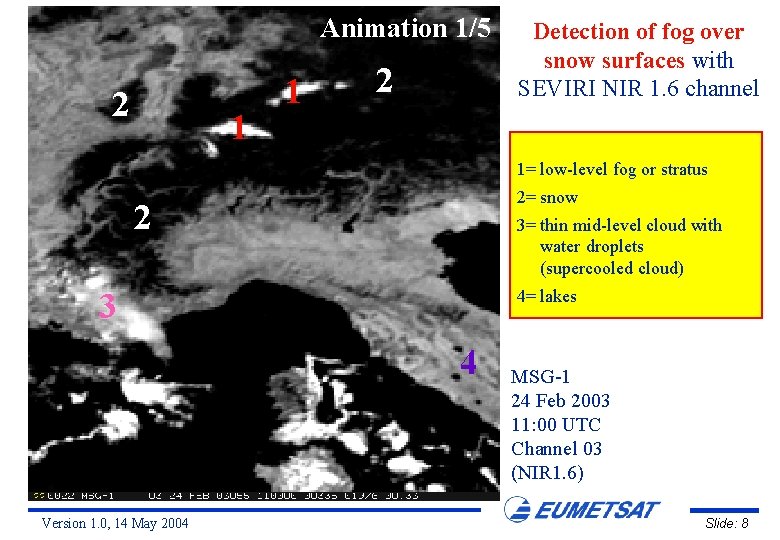
Animation 1/5 2 1 1 2 Detection of fog over snow surfaces with SEVIRI NIR 1. 6 channel 1= low-level fog or stratus 2= snow 2 3= thin mid-level cloud with water droplets (supercooled cloud) 4= lakes 3 4 Version 1. 0, 14 May 2004 MSG-1 24 Feb 2003 11: 00 UTC Channel 03 (NIR 1. 6) Slide: 8

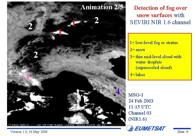
Animation 2/5 2 1 1 2 Detection of fog over snow surfaces with SEVIRI NIR 1. 6 channel 1= low-level fog or stratus 2= snow 2 3= thin mid-level cloud with water droplets (supercooled cloud) 4= lakes 3 4 Version 1. 0, 14 May 2004 MSG-1 24 Feb 2003 11: 15 UTC Channel 03 (NIR 1. 6) Slide: 9

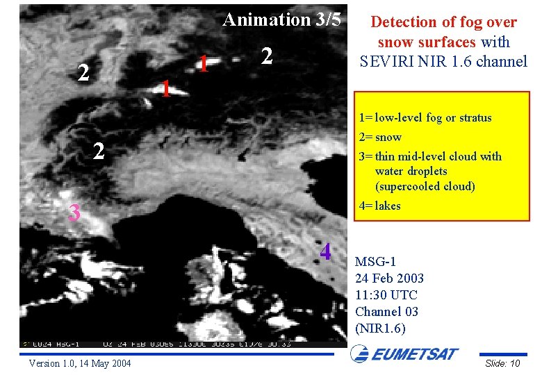
Animation 3/5 2 1 1 2 Detection of fog over snow surfaces with SEVIRI NIR 1. 6 channel 1= low-level fog or stratus 2= snow 2 3= thin mid-level cloud with water droplets (supercooled cloud) 4= lakes 3 4 Version 1. 0, 14 May 2004 MSG-1 24 Feb 2003 11: 30 UTC Channel 03 (NIR 1. 6) Slide: 10

Animation 4/5 2 1 1 2 Detection of fog over snow surfaces with SEVIRI NIR 1. 6 channel 1= low-level fog or stratus 2= snow 2 3= thin mid-level cloud with water droplets (supercooled cloud) 4= lakes 3 4 Version 1. 0, 14 May 2004 MSG-1 24 Feb 2003 11: 45 UTC Channel 03 (NIR 1. 6) Slide: 11

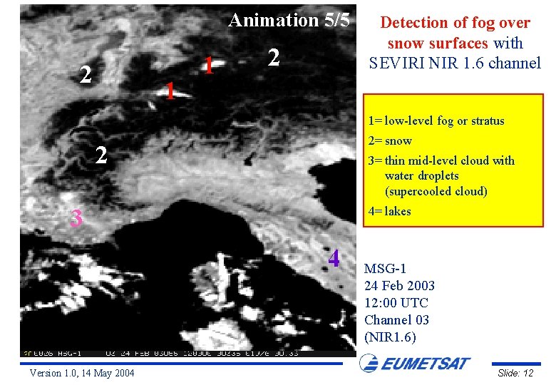
Animation 5/5 2 1 1 2 Detection of fog over snow surfaces with SEVIRI NIR 1. 6 channel 1= low-level fog or stratus 2= snow 2 3= thin mid-level cloud with water droplets (supercooled cloud) 4= lakes 3 4 Version 1. 0, 14 May 2004 MSG-1 24 Feb 2003 12: 00 UTC Channel 03 (NIR 1. 6) Slide: 12

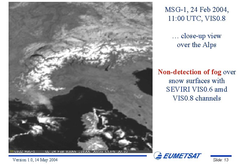
MSG-1, 24 Feb 2004, 11: 00 UTC, VIS 0. 8 … close-up view over the Alps Non-detection of fog over snow surfaces with SEVIRI VIS 0. 6 amd VIS 0. 8 channels Version 1. 0, 14 May 2004 Slide: 13

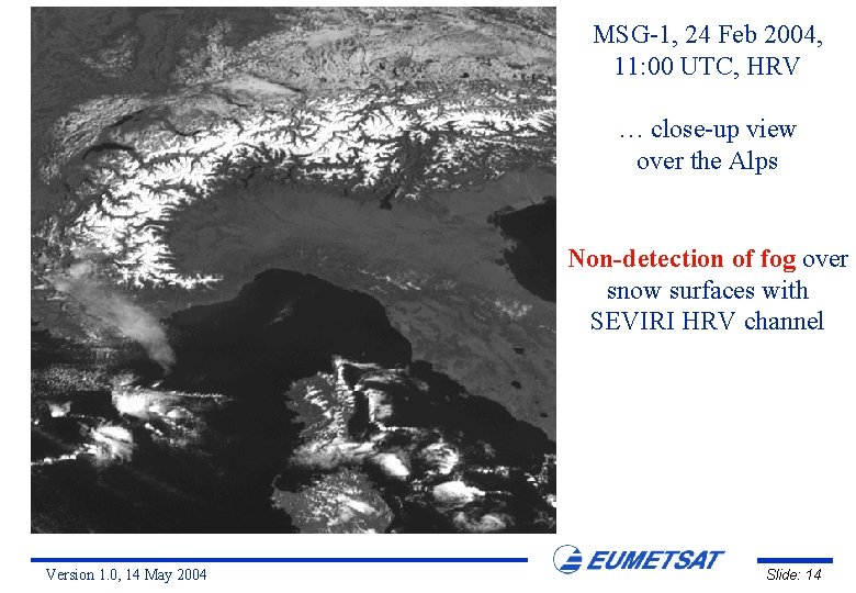
MSG-1, 24 Feb 2004, 11: 00 UTC, HRV … close-up view over the Alps Non-detection of fog over snow surfaces with SEVIRI HRV channel Version 1. 0, 14 May 2004 Slide: 14

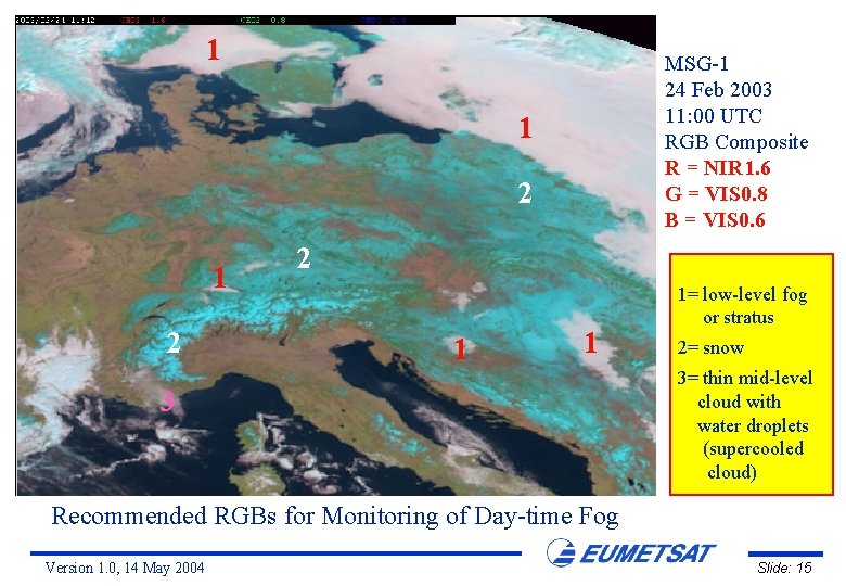
1 MSG-1 24 Feb 2003 11: 00 UTC RGB Composite R = NIR 1. 6 G = VIS 0. 8 B = VIS 0. 6 1 2 2 1 1 3 1= low-level fog or stratus 2= snow 3= thin mid-level cloud with water droplets (supercooled cloud) Recommended RGBs for Monitoring of Day-time Fog Version 1. 0, 14 May 2004 Slide: 15

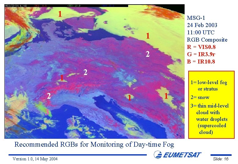
1 MSG-1 24 Feb 2003 11: 00 UTC RGB Composite R = VIS 0. 8 G = IR 3. 9 r B = IR 10. 8 1 2 2 1 1 3 1= low-level fog or stratus 2= snow 3= thin mid-level cloud with water droplets (supercooled cloud) Recommended RGBs for Monitoring of Day-time Fog Version 1. 0, 14 May 2004 Slide: 16

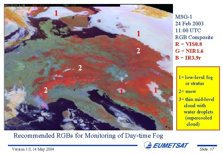
1 MSG-1 24 Feb 2003 11: 00 UTC RGB Composite R = VIS 0. 8 G = NIR 1. 6 B = IR 3. 9 r 1 2 2 1 1 3 1= low-level fog or stratus 2= snow 3= thin mid-level cloud with water droplets (supercooled cloud) Recommended RGBs for Monitoring of Day-time Fog Version 1. 0, 14 May 2004 Slide: 17

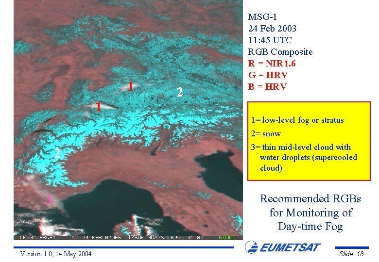
1 1 2 MSG-1 24 Feb 2003 11: 45 UTC RGB Composite R = NIR 1. 6 G = HRV B = HRV 1= low-level fog or stratus 2= snow 2 3 Version 1. 0, 14 May 2004 3= thin mid-level cloud with water droplets (supercooled cloud) Recommended RGBs for Monitoring of Day-time Fog Slide: 18

Night-time Fog over France 14 July 2003 Version 1. 0, 14 May 2004 Slide: 19

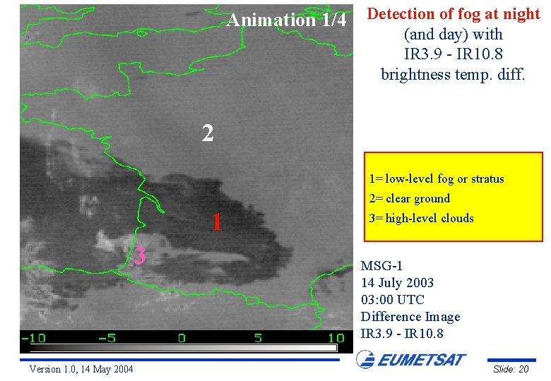
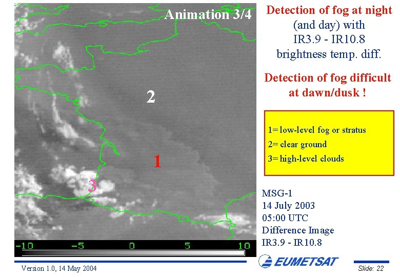
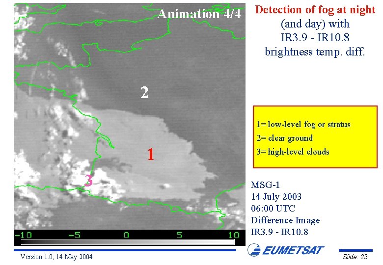
Animation 1/4 Detection of fog at night (and day) with IR 3. 9 - IR 10. 8 brightness temp. diff. 2 1= low-level fog or stratus 2= clear ground 1 3 Version 1. 0, 14 May 2004 3= high-level clouds MSG-1 14 July 2003 03: 00 UTC Difference Image IR 3. 9 - IR 10. 8 Slide: 20

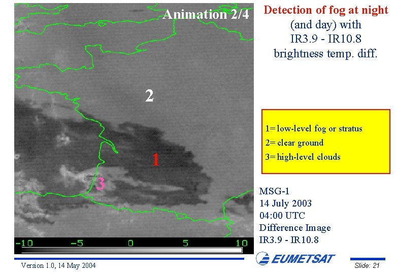
Animation 2/4 Detection of fog at night (and day) with IR 3. 9 - IR 10. 8 brightness temp. diff. 2 1= low-level fog or stratus 2= clear ground 1 3 Version 1. 0, 14 May 2004 3= high-level clouds MSG-1 14 July 2003 04: 00 UTC Difference Image IR 3. 9 - IR 10. 8 Slide: 21

Animation 3/4 Detection of fog at night (and day) with IR 3. 9 - IR 10. 8 brightness temp. diff. 2 Detection of fog difficult at dawn/dusk ! 1= low-level fog or stratus 2= clear ground 1 3 Version 1. 0, 14 May 2004 3= high-level clouds MSG-1 14 July 2003 05: 00 UTC Difference Image IR 3. 9 - IR 10. 8 Slide: 22

Animation 4/4 Detection of fog at night (and day) with IR 3. 9 - IR 10. 8 brightness temp. diff. 2 1= low-level fog or stratus 2= clear ground 1 3 Version 1. 0, 14 May 2004 3= high-level clouds MSG-1 14 July 2003 06: 00 UTC Difference Image IR 3. 9 - IR 10. 8 Slide: 23

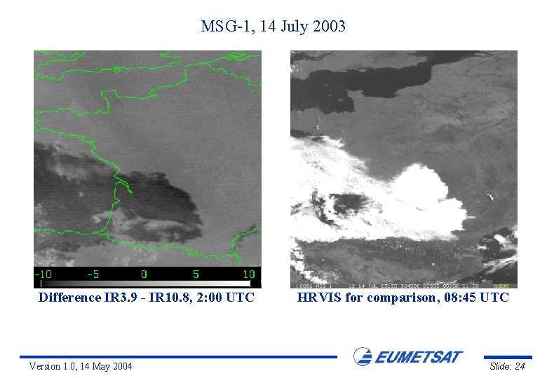
MSG-1, 14 July 2003 Difference IR 3. 9 - IR 10. 8, 2: 00 UTC Version 1. 0, 14 May 2004 HRVIS for comparison, 08: 45 UTC Slide: 24

Night-time Fog over S. Africa 24 April 2003 Version 1. 0, 14 May 2004 Slide: 25

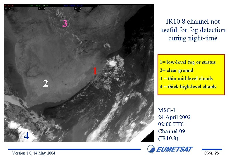
IR 10. 8 channel not useful for fog detection during night-time 3 1= low-level fog or stratus 1 2 4 Version 1. 0, 14 May 2004 2= clear ground 3 = thin mid-level clouds 4 = thick high-level clouds MSG-1 24 April 2003 02: 00 UTC Channel 09 (IR 10. 8) Slide: 26

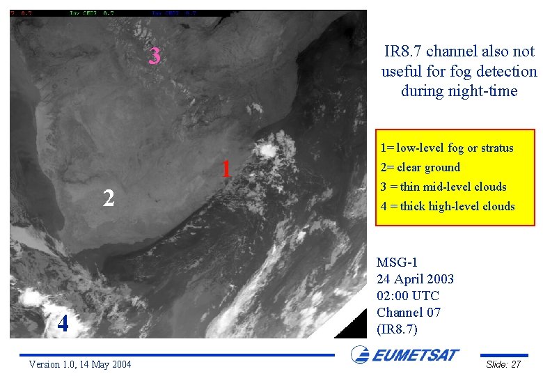
IR 8. 7 channel also not useful for fog detection during night-time 3 1= low-level fog or stratus 1 2 4 Version 1. 0, 14 May 2004 2= clear ground 3 = thin mid-level clouds 4 = thick high-level clouds MSG-1 24 April 2003 02: 00 UTC Channel 07 (IR 8. 7) Slide: 27

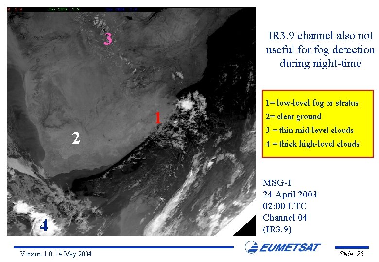
IR 3. 9 channel also not useful for fog detection during night-time 3 1= low-level fog or stratus 1 2 4 Version 1. 0, 14 May 2004 2= clear ground 3 = thin mid-level clouds 4 = thick high-level clouds MSG-1 24 April 2003 02: 00 UTC Channel 04 (IR 3. 9) Slide: 28

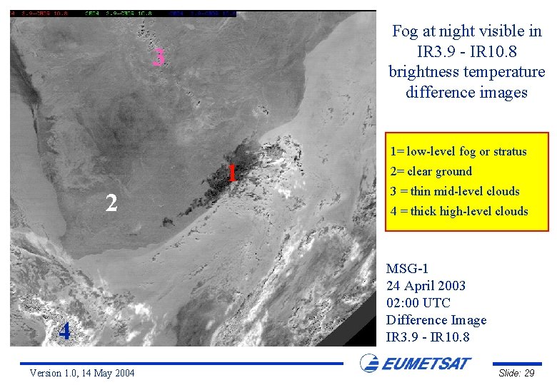
Fog at night visible in IR 3. 9 - IR 10. 8 brightness temperature difference images 3 1= low-level fog or stratus 1 2 4 Version 1. 0, 14 May 2004 2= clear ground 3 = thin mid-level clouds 4 = thick high-level clouds MSG-1 24 April 2003 02: 00 UTC Difference Image IR 3. 9 - IR 10. 8 Slide: 29

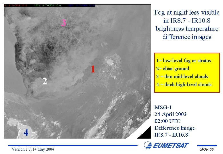
Fog at night less visible in IR 8. 7 - IR 10. 8 brightness temperature difference images 3 1= low-level fog or stratus 1 2 4 Version 1. 0, 14 May 2004 2= clear ground 3 = thin mid-level clouds 4 = thick high-level clouds MSG-1 24 April 2003 02: 00 UTC Difference Image IR 8. 7 - IR 10. 8 Slide: 30

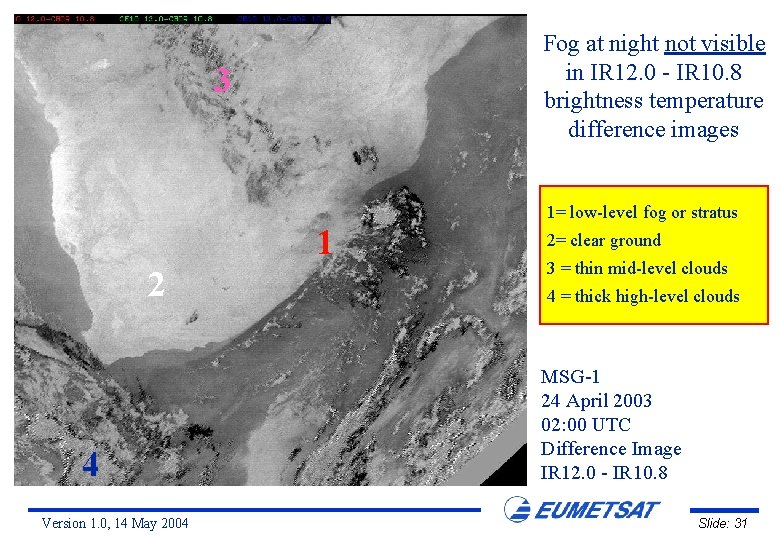
Fog at night not visible in IR 12. 0 - IR 10. 8 brightness temperature difference images 3 1= low-level fog or stratus 1 2 4 Version 1. 0, 14 May 2004 2= clear ground 3 = thin mid-level clouds 4 = thick high-level clouds MSG-1 24 April 2003 02: 00 UTC Difference Image IR 12. 0 - IR 10. 8 Slide: 31

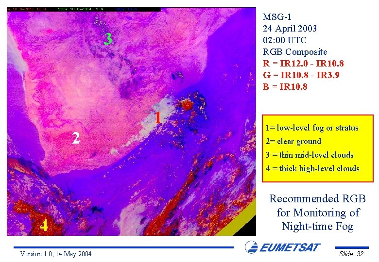
MSG-1 24 April 2003 02: 00 UTC RGB Composite R = IR 12. 0 - IR 10. 8 G = IR 10. 8 - IR 3. 9 B = IR 10. 8 3 1 2 1= low-level fog or stratus 2= clear ground 3 = thin mid-level clouds 4 = thick high-level clouds 4 Version 1. 0, 14 May 2004 Recommended RGB for Monitoring of Night-time Fog Slide: 32

Night-time Fog over Central Europe 25 October 2003 Version 1. 0, 14 May 2004 Slide: 33

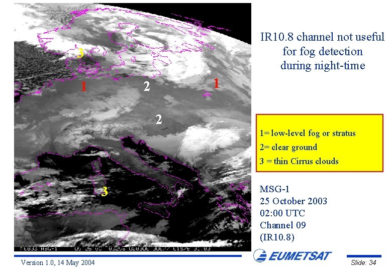
IR 10. 8 channel not useful for fog detection during night-time 3 1 1 2 2 1= low-level fog or stratus 2= clear ground 3 = thin Cirrus clouds 3 Version 1. 0, 14 May 2004 MSG-1 25 October 2003 02: 00 UTC Channel 09 (IR 10. 8) Slide: 34

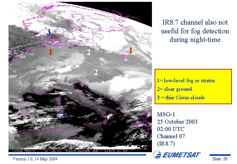
IR 8. 7 channel also not useful for fog detection during night-time 3 1 1 2 2 1= low-level fog or stratus 2= clear ground 3 = thin Cirrus clouds 3 Version 1. 0, 14 May 2004 MSG-1 25 October 2003 02: 00 UTC Channel 07 (IR 8. 7) Slide: 35

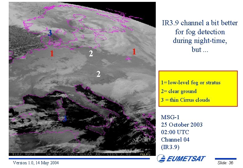
3 1 1 2 IR 3. 9 channel a bit better fog detection during night-time, but. . . 2 1= low-level fog or stratus 2= clear ground 3 = thin Cirrus clouds 3 Version 1. 0, 14 May 2004 MSG-1 25 October 2003 02: 00 UTC Channel 04 (IR 3. 9) Slide: 36

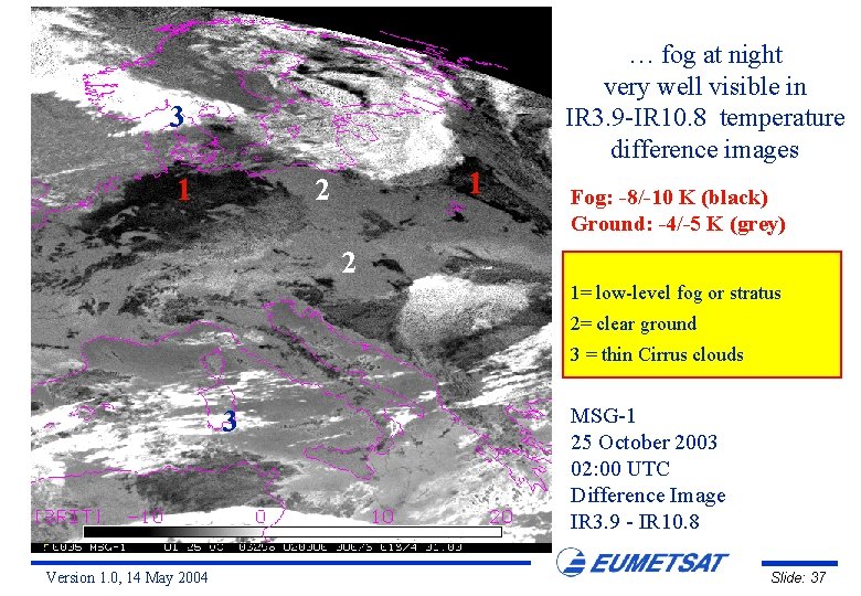
… fog at night very well visible in IR 3. 9 -IR 10. 8 temperature difference images 3 1 1 2 Fog: -8/-10 K (black) Ground: -4/-5 K (grey) 2 1= low-level fog or stratus 2= clear ground 3 = thin Cirrus clouds 3 Version 1. 0, 14 May 2004 MSG-1 25 October 2003 02: 00 UTC Difference Image IR 3. 9 - IR 10. 8 Slide: 37

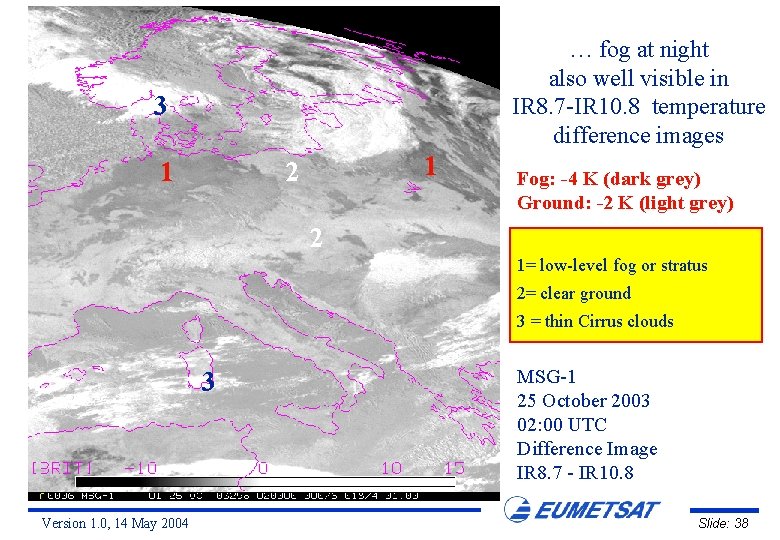
… fog at night also well visible in IR 8. 7 -IR 10. 8 temperature difference images 3 1 1 2 Fog: -4 K (dark grey) Ground: -2 K (light grey) 2 1= low-level fog or stratus 2= clear ground 3 = thin Cirrus clouds 3 Version 1. 0, 14 May 2004 MSG-1 25 October 2003 02: 00 UTC Difference Image IR 8. 7 - IR 10. 8 Slide: 38

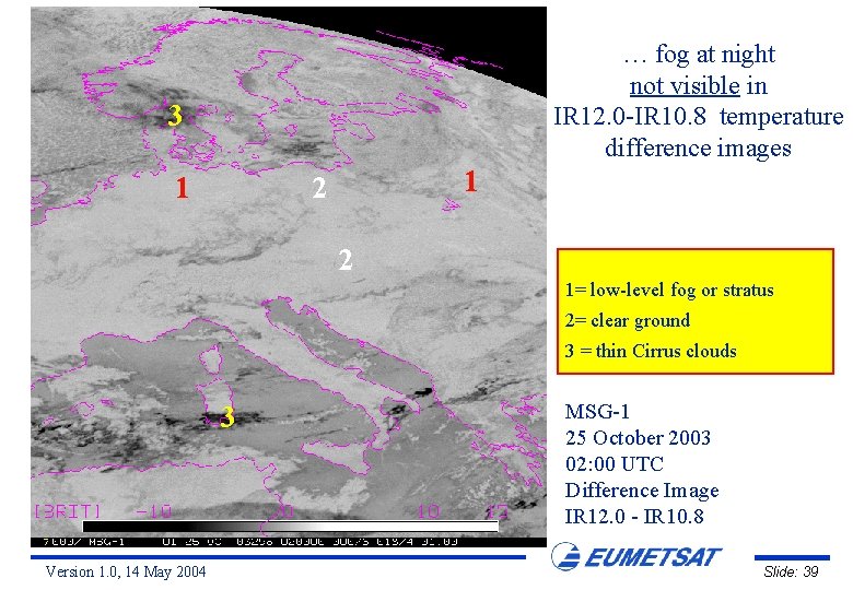
… fog at night not visible in IR 12. 0 -IR 10. 8 temperature difference images 3 1 1 2 2 1= low-level fog or stratus 2= clear ground 3 = thin Cirrus clouds 3 Version 1. 0, 14 May 2004 MSG-1 25 October 2003 02: 00 UTC Difference Image IR 12. 0 - IR 10. 8 Slide: 39

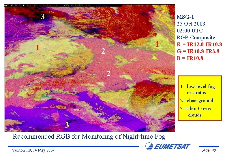
3 1 1 2 MSG-1 25 Oct 2003 02: 00 UTC RGB Composite R = IR 12. 0 -IR 10. 8 G = IR 10. 8 -IR 3. 9 B = IR 10. 8 2 1= low-level fog or stratus 2= clear ground 3 = thin Cirrus clouds 3 Recommended RGB for Monitoring of Night-time Fog Version 1. 0, 14 May 2004 Slide: 40

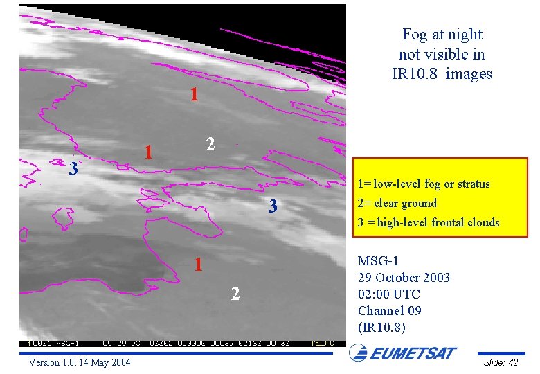
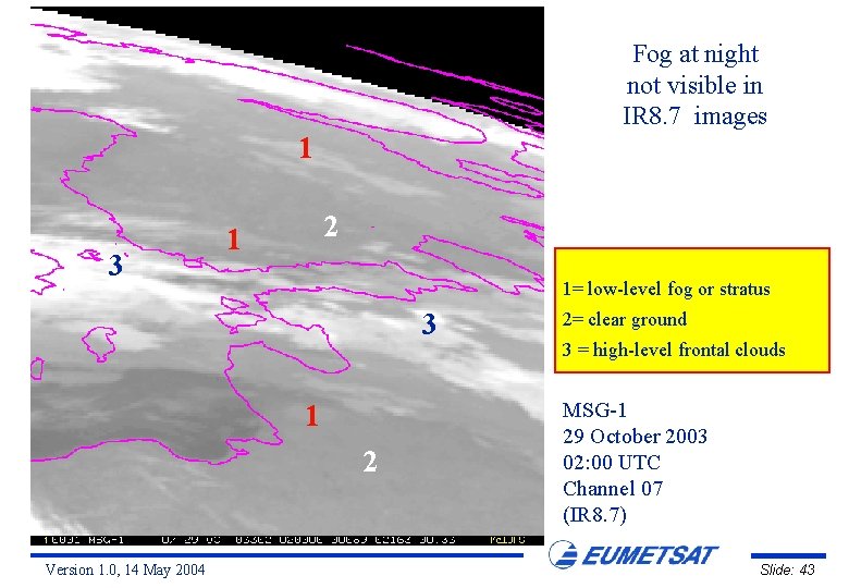
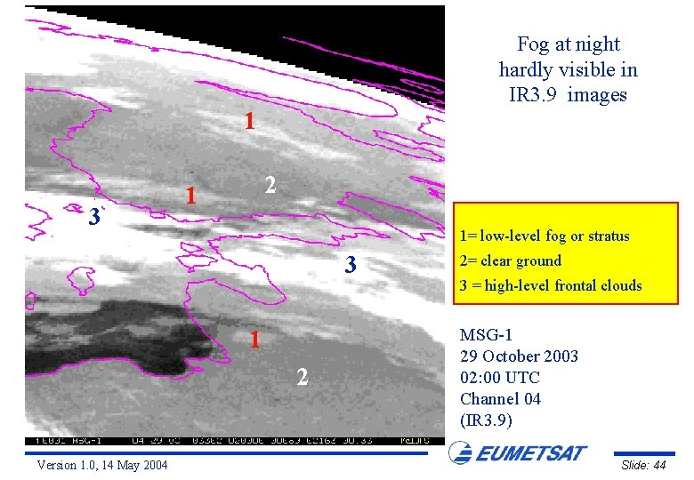
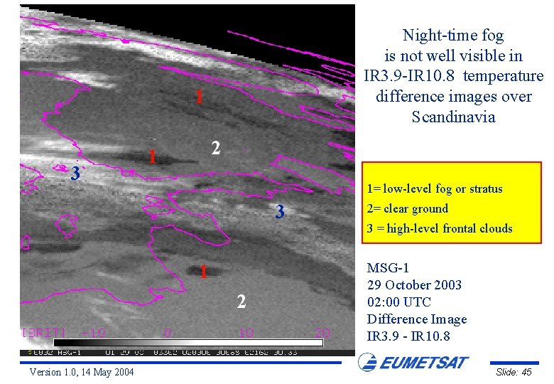
Night-time Fog over Southern Finland 29 October 2003 Version 1. 0, 14 May 2004 Slide: 41

Fog at night not visible in IR 10. 8 images 1 3 2 1 1= low-level fog or stratus 3 1 2 Version 1. 0, 14 May 2004 2= clear ground 3 = high-level frontal clouds MSG-1 29 October 2003 02: 00 UTC Channel 09 (IR 10. 8) Slide: 42

Fog at night not visible in IR 8. 7 images 1 3 2 1 1= low-level fog or stratus 3 1 2 Version 1. 0, 14 May 2004 2= clear ground 3 = high-level frontal clouds MSG-1 29 October 2003 02: 00 UTC Channel 07 (IR 8. 7) Slide: 43

Fog at night hardly visible in IR 3. 9 images 1 3 2 1 1= low-level fog or stratus 3 1 2 Version 1. 0, 14 May 2004 2= clear ground 3 = high-level frontal clouds MSG-1 29 October 2003 02: 00 UTC Channel 04 (IR 3. 9) Slide: 44

Night-time fog is not well visible in IR 3. 9 -IR 10. 8 temperature difference images over Scandinavia 1 3 2 1 1= low-level fog or stratus 3 1 2 Version 1. 0, 14 May 2004 2= clear ground 3 = high-level frontal clouds MSG-1 29 October 2003 02: 00 UTC Difference Image IR 3. 9 - IR 10. 8 Slide: 45

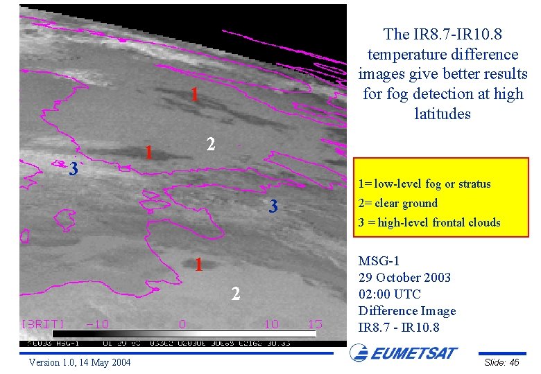
The IR 8. 7 -IR 10. 8 temperature difference images give better results for fog detection at high latitudes 1 3 2 1 1= low-level fog or stratus 3 1 2 Version 1. 0, 14 May 2004 2= clear ground 3 = high-level frontal clouds MSG-1 29 October 2003 02: 00 UTC Difference Image IR 8. 7 - IR 10. 8 Slide: 46

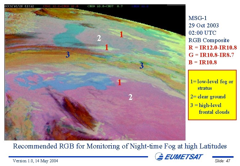
2 3 1 1 3 1 MSG-1 29 Oct 2003 02: 00 UTC RGB Composite R = IR 12. 0 -IR 10. 8 G = IR 10. 8 -IR 8. 7 B = IR 10. 8 1= low-level fog or stratus 2 2= clear ground 3 = high-level frontal clouds Recommended RGB for Monitoring of Night-time Fog at high Latitudes Version 1. 0, 14 May 2004 Slide: 47

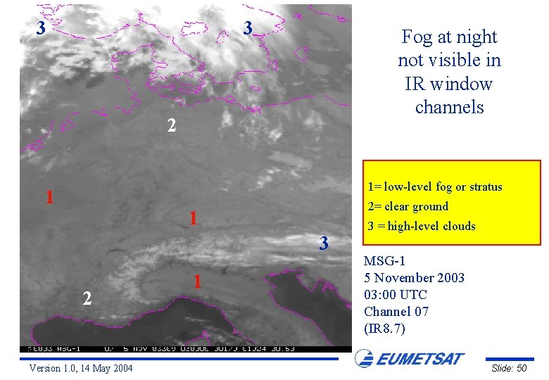
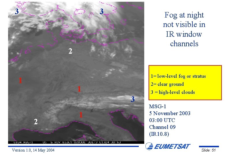
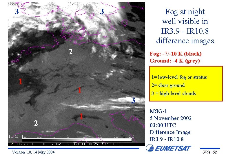
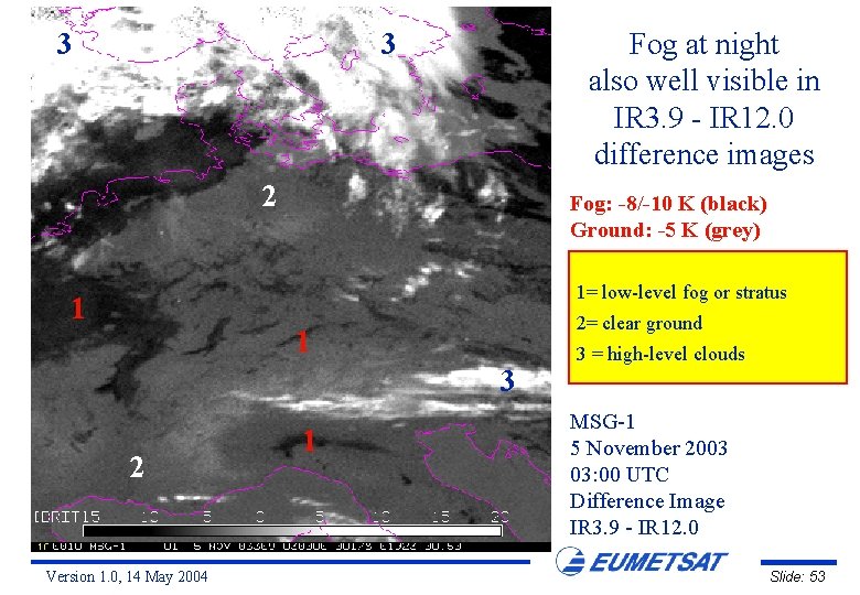
Night-time Fog over Central Europe 5 November 2003 Version 1. 0, 14 May 2004 Slide: 48

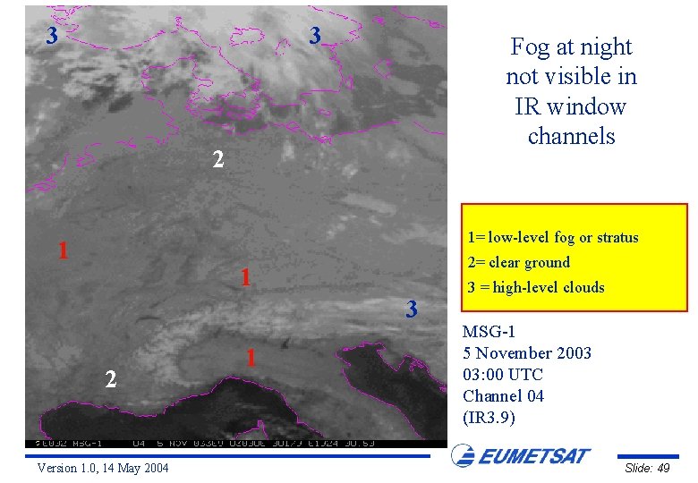
3 3 Fog at night not visible in IR window channels 2 1= low-level fog or stratus 1 2= clear ground 1 3 2 Version 1. 0, 14 May 2004 1 3 = high-level clouds MSG-1 5 November 2003 03: 00 UTC Channel 04 (IR 3. 9) Slide: 49

3 3 Fog at night not visible in IR window channels 2 1= low-level fog or stratus 1 2= clear ground 1 3 2 Version 1. 0, 14 May 2004 1 3 = high-level clouds MSG-1 5 November 2003 03: 00 UTC Channel 07 (IR 8. 7) Slide: 50

3 3 Fog at night not visible in IR window channels 2 1= low-level fog or stratus 1 2= clear ground 1 3 2 Version 1. 0, 14 May 2004 1 3 = high-level clouds MSG-1 5 November 2003 03: 00 UTC Channel 09 (IR 10. 8) Slide: 51

3 Fog at night well visible in IR 3. 9 - IR 10. 8 difference images 3 2 Fog: -7/-10 K (black) Ground: -4 K (grey) 1= low-level fog or stratus 1 2= clear ground 1 3 2 Version 1. 0, 14 May 2004 1 3 = high-level clouds MSG-1 5 November 2003 03: 00 UTC Difference Image IR 3. 9 - IR 10. 8 Slide: 52

3 Fog at night also well visible in IR 3. 9 - IR 12. 0 difference images 3 2 Fog: -8/-10 K (black) Ground: -5 K (grey) 1= low-level fog or stratus 1 2= clear ground 1 3 2 Version 1. 0, 14 May 2004 1 3 = high-level clouds MSG-1 5 November 2003 03: 00 UTC Difference Image IR 3. 9 - IR 12. 0 Slide: 53

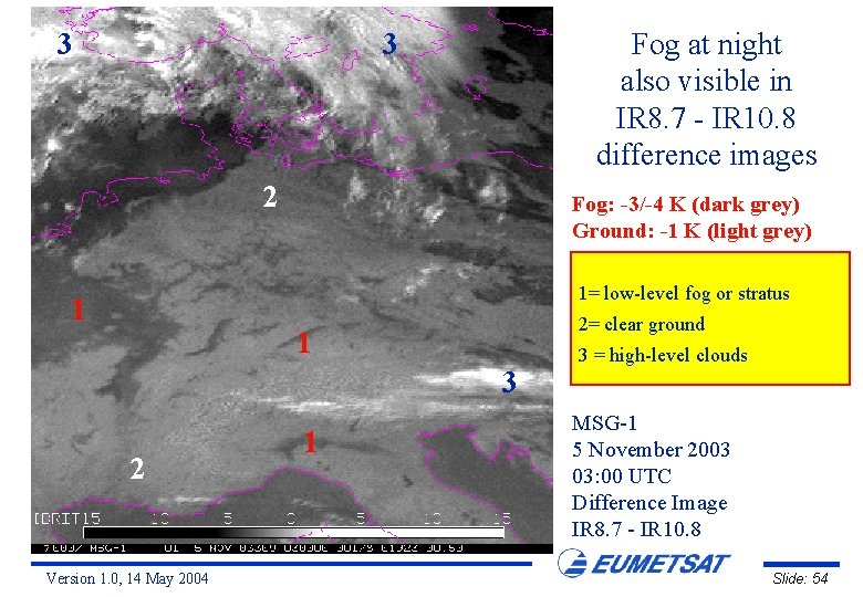
3 Fog at night also visible in IR 8. 7 - IR 10. 8 difference images 3 2 Fog: -3/-4 K (dark grey) Ground: -1 K (light grey) 1= low-level fog or stratus 1 2= clear ground 1 3 2 Version 1. 0, 14 May 2004 1 3 = high-level clouds MSG-1 5 November 2003 03: 00 UTC Difference Image IR 8. 7 - IR 10. 8 Slide: 54

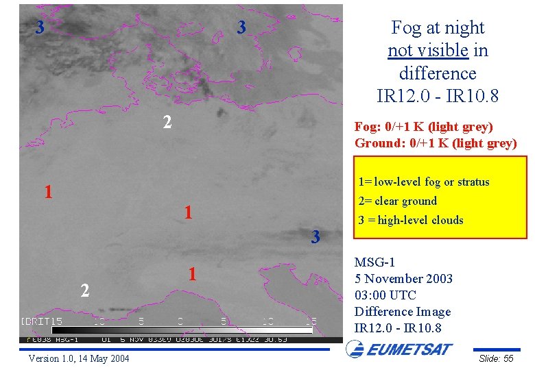
3 Fog at night not visible in difference IR 12. 0 - IR 10. 8 3 2 Fog: 0/+1 K (light grey) Ground: 0/+1 K (light grey) 1= low-level fog or stratus 1 2= clear ground 1 3 2 Version 1. 0, 14 May 2004 1 3 = high-level clouds MSG-1 5 November 2003 03: 00 UTC Difference Image IR 12. 0 - IR 10. 8 Slide: 55

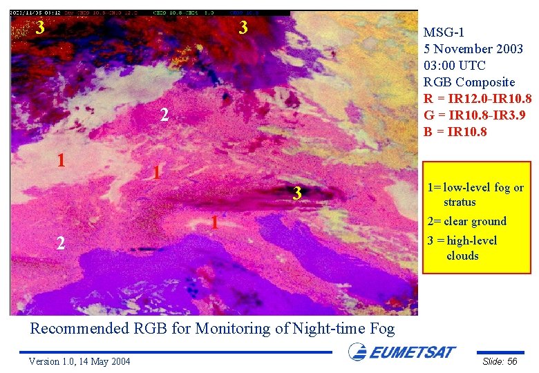
3 3 MSG-1 5 November 2003 03: 00 UTC RGB Composite R = IR 12. 0 -IR 10. 8 G = IR 10. 8 -IR 3. 9 B = IR 10. 8 2 1 3 1 1= low-level fog or stratus 2= clear ground 3 = high-level clouds Recommended RGB for Monitoring of Night-time Fog Version 1. 0, 14 May 2004 Slide: 56

Day-time Fog over Central Europe 5 November 2003 Version 1. 0, 14 May 2004 Slide: 57

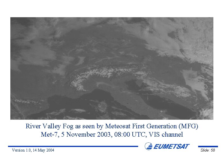
River Valley Fog as seen by Meteosat First Generation (MFG) Met-7, 5 November 2003, 08: 00 UTC, VIS channel Version 1. 0, 14 May 2004 Slide: 58

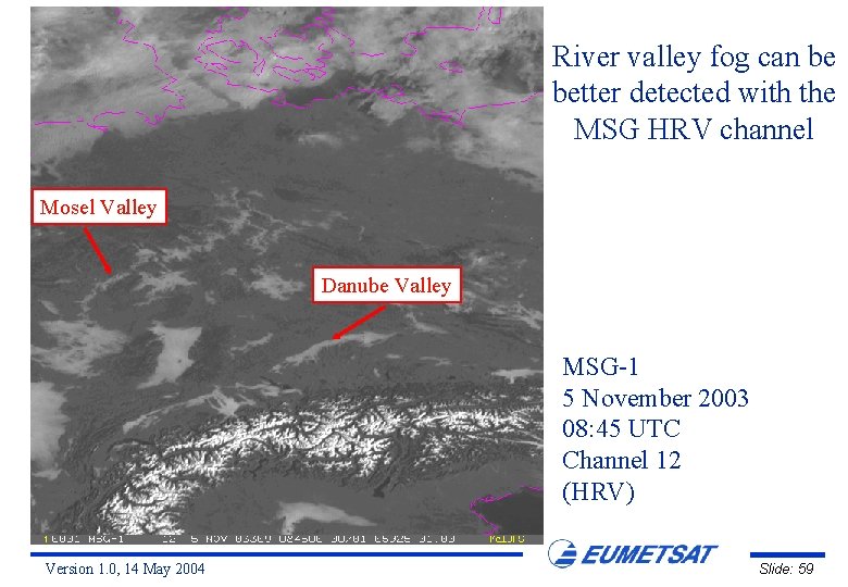
River valley fog can be better detected with the MSG HRV channel Mosel Valley Danube Valley MSG-1 5 November 2003 08: 45 UTC Channel 12 (HRV) Version 1. 0, 14 May 2004 Slide: 59

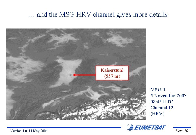
… and the MSG HRV channel gives more details Kaiserstuhl (557 m) MSG-1 5 November 2003 08: 45 UTC Channel 12 (HRV) Version 1. 0, 14 May 2004 Slide: 60

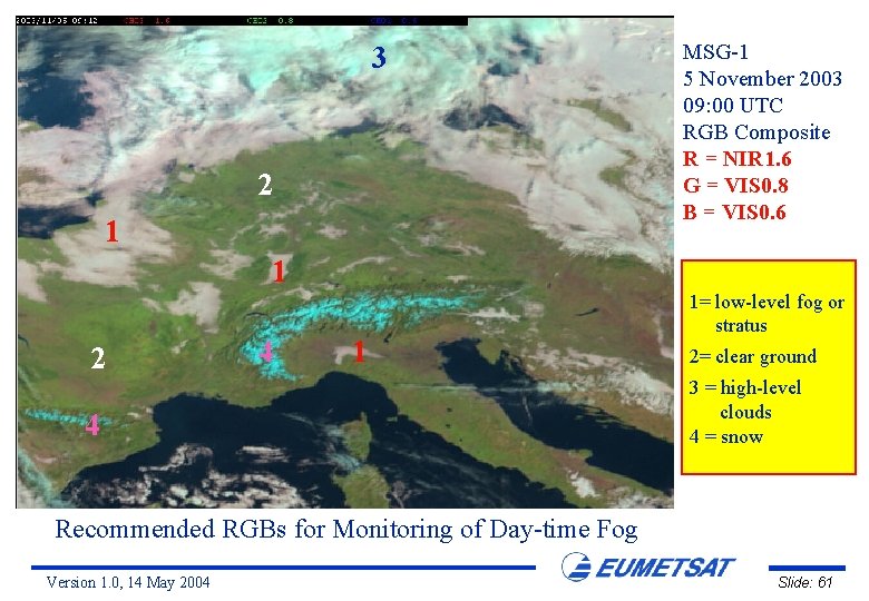
3 2 1 MSG-1 5 November 2003 09: 00 UTC RGB Composite R = NIR 1. 6 G = VIS 0. 8 B = VIS 0. 6 1 2 4 1= low-level fog or stratus 2= clear ground 3 = high-level clouds 4 = snow Recommended RGBs for Monitoring of Day-time Fog Version 1. 0, 14 May 2004 Slide: 61

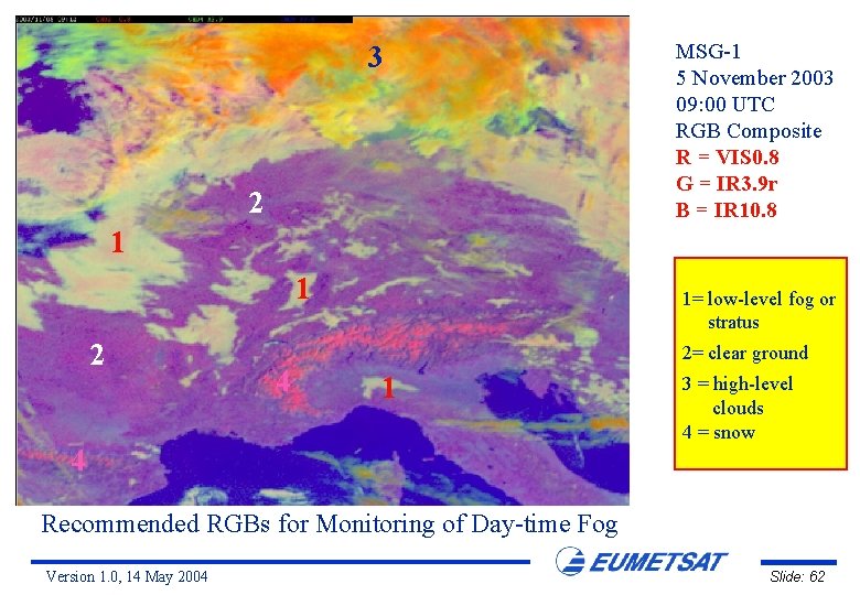
3 2 MSG-1 5 November 2003 09: 00 UTC RGB Composite R = VIS 0. 8 G = IR 3. 9 r B = IR 10. 8 1 1 2 4 1= low-level fog or stratus 2= clear ground 1 3 = high-level clouds 4 = snow 4 Recommended RGBs for Monitoring of Day-time Fog Version 1. 0, 14 May 2004 Slide: 62

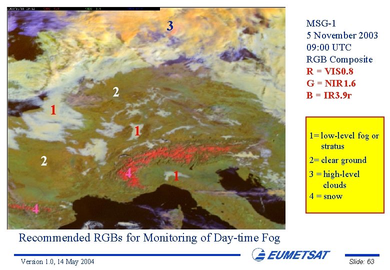
3 2 MSG-1 5 November 2003 09: 00 UTC RGB Composite R = VIS 0. 8 G = NIR 1. 6 B = IR 3. 9 r 1 1 2 4 1= low-level fog or stratus 2= clear ground 1 3 = high-level clouds 4 = snow 4 Recommended RGBs for Monitoring of Day-time Fog Version 1. 0, 14 May 2004 Slide: 63

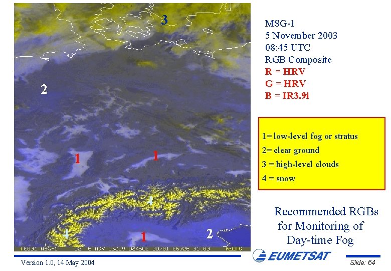
3 MSG-1 5 November 2003 08: 45 UTC RGB Composite R = HRV G = HRV B = IR 3. 9 i 2 1= low-level fog or stratus 2= clear ground 1 1 3 = high-level clouds 4 = snow 4 4 Version 1. 0, 14 May 2004 1 2 Recommended RGBs for Monitoring of Day-time Fog Slide: 64

Night-time Fog over Europe 9 November 2003 Version 1. 0, 14 May 2004 Slide: 65

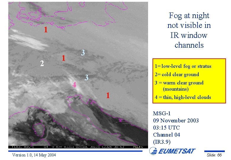
Fog at night not visible in IR window channels 1 2 3 1 1= low-level fog or stratus 4 2= cold clear ground 3 1 3 = warm clear ground (mountains) 4 = thin, high-level clouds MSG-1 09 November 2003 03: 15 UTC Channel 04 (IR 3. 9) Version 1. 0, 14 May 2004 Slide: 66

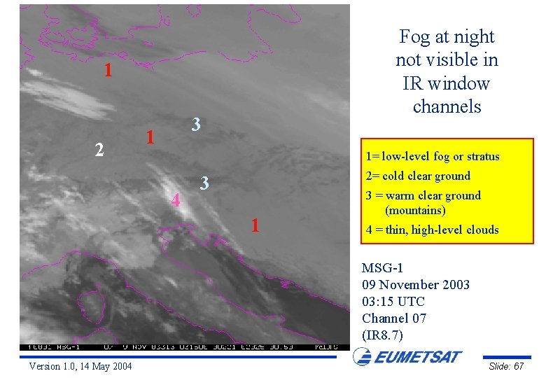
Fog at night not visible in IR window channels 1 2 3 1 1= low-level fog or stratus 4 2= cold clear ground 3 1 3 = warm clear ground (mountains) 4 = thin, high-level clouds MSG-1 09 November 2003 03: 15 UTC Channel 07 (IR 8. 7) Version 1. 0, 14 May 2004 Slide: 67

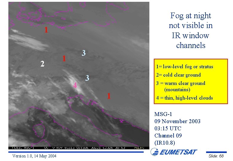
Fog at night not visible in IR window channels 1 2 3 1 1= low-level fog or stratus 4 2= cold clear ground 3 1 3 = warm clear ground (mountains) 4 = thin, high-level clouds MSG-1 09 November 2003 03: 15 UTC Channel 09 (IR 10. 8) Version 1. 0, 14 May 2004 Slide: 68

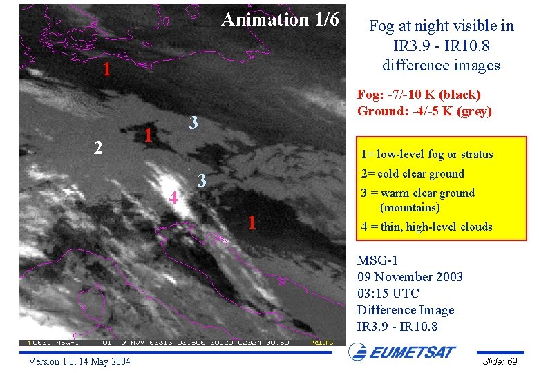
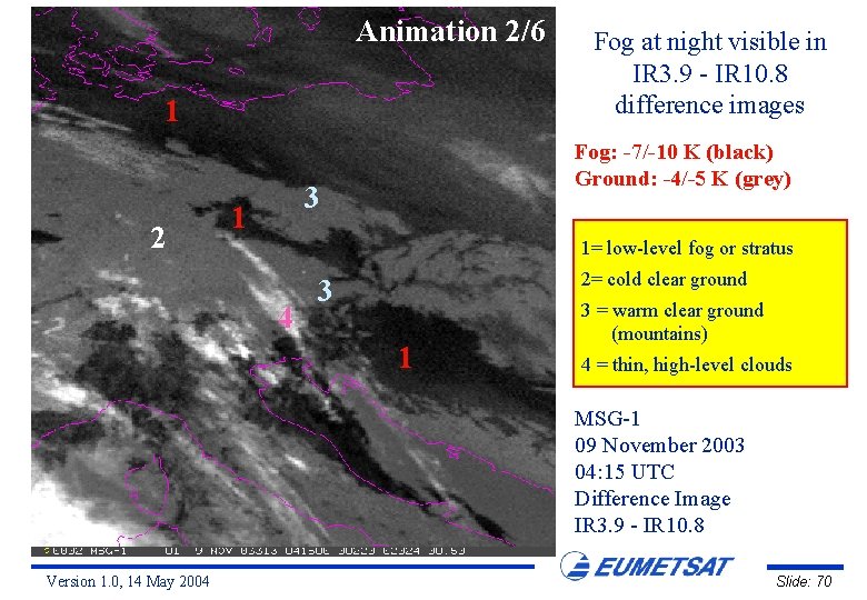
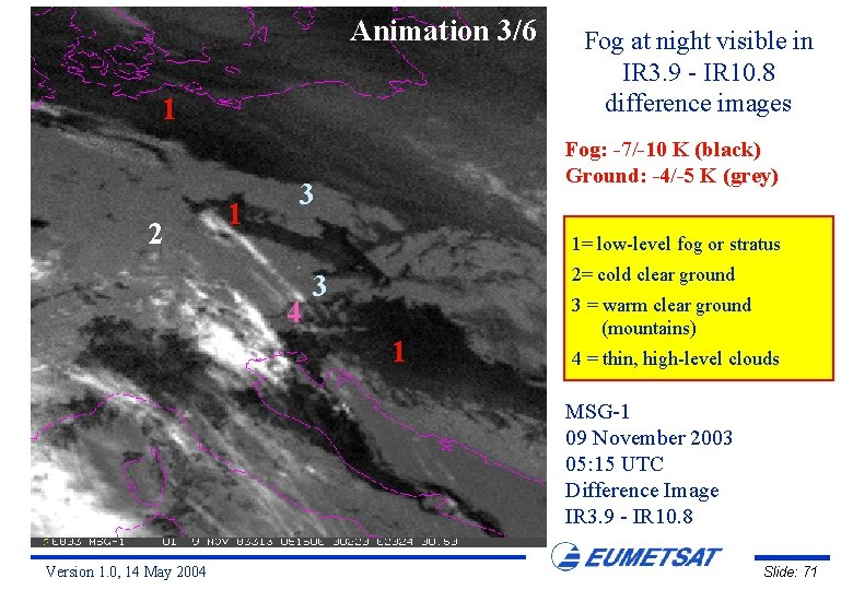
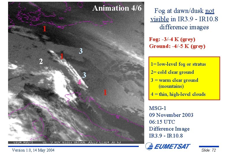
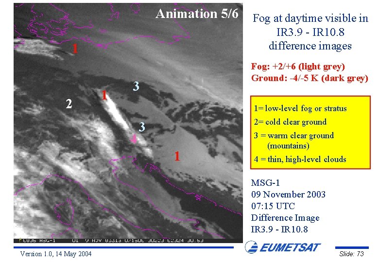
Animation 1/6 1 2 Fog: -7/-10 K (black) Ground: -4/-5 K (grey) 3 1 Fog at night visible in IR 3. 9 - IR 10. 8 difference images 1= low-level fog or stratus 4 2= cold clear ground 3 1 3 = warm clear ground (mountains) 4 = thin, high-level clouds MSG-1 09 November 2003 03: 15 UTC Difference Image IR 3. 9 - IR 10. 8 Version 1. 0, 14 May 2004 Slide: 69

Animation 2/6 1 2 Fog: -7/-10 K (black) Ground: -4/-5 K (grey) 3 1 Fog at night visible in IR 3. 9 - IR 10. 8 difference images 1= low-level fog or stratus 4 2= cold clear ground 3 1 3 = warm clear ground (mountains) 4 = thin, high-level clouds MSG-1 09 November 2003 04: 15 UTC Difference Image IR 3. 9 - IR 10. 8 Version 1. 0, 14 May 2004 Slide: 70

Animation 3/6 1 2 1 Fog at night visible in IR 3. 9 - IR 10. 8 difference images Fog: -7/-10 K (black) Ground: -4/-5 K (grey) 3 1= low-level fog or stratus 4 2= cold clear ground 3 1 3 = warm clear ground (mountains) 4 = thin, high-level clouds MSG-1 09 November 2003 05: 15 UTC Difference Image IR 3. 9 - IR 10. 8 Version 1. 0, 14 May 2004 Slide: 71

Animation 4/6 1 2 1 Fog at dawn/dusk not visible in IR 3. 9 - IR 10. 8 difference images Fog: -3/-4 K (grey) Ground: -4/-5 K (grey) 3 1= low-level fog or stratus 4 2= cold clear ground 3 1 3 = warm clear ground (mountains) 4 = thin, high-level clouds MSG-1 09 November 2003 06: 15 UTC Difference Image IR 3. 9 - IR 10. 8 Version 1. 0, 14 May 2004 Slide: 72

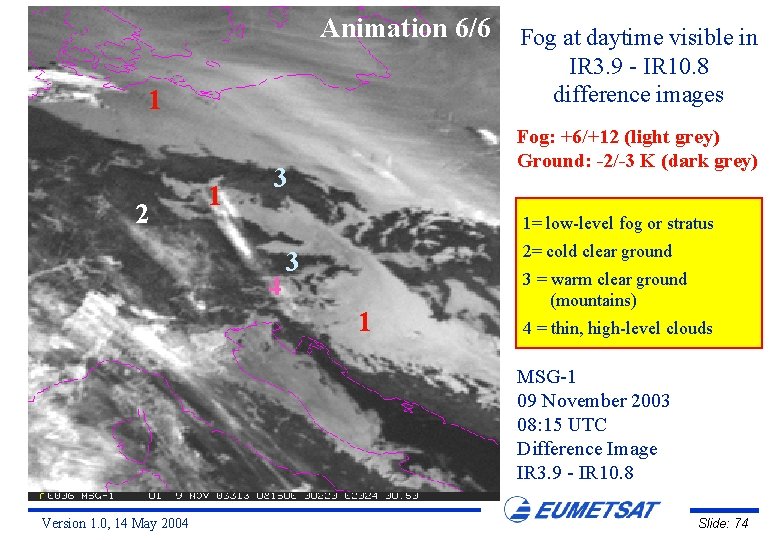
Animation 5/6 1 2 1 Fog at daytime visible in IR 3. 9 - IR 10. 8 difference images Fog: +2/+6 (light grey) Ground: -4/-5 K (dark grey) 3 1= low-level fog or stratus 4 2= cold clear ground 3 1 3 = warm clear ground (mountains) 4 = thin, high-level clouds MSG-1 09 November 2003 07: 15 UTC Difference Image IR 3. 9 - IR 10. 8 Version 1. 0, 14 May 2004 Slide: 73

Animation 6/6 1 2 1 Fog at daytime visible in IR 3. 9 - IR 10. 8 difference images Fog: +6/+12 (light grey) Ground: -2/-3 K (dark grey) 3 1= low-level fog or stratus 4 2= cold clear ground 3 1 3 = warm clear ground (mountains) 4 = thin, high-level clouds MSG-1 09 November 2003 08: 15 UTC Difference Image IR 3. 9 - IR 10. 8 Version 1. 0, 14 May 2004 Slide: 74

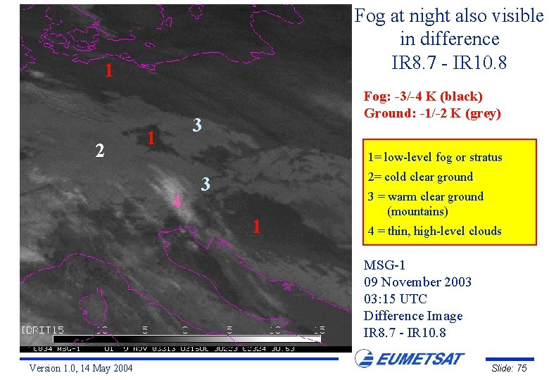
Fog at night also visible in difference IR 8. 7 - IR 10. 8 1 2 Fog: -3/-4 K (black) Ground: -1/-2 K (grey) 3 1 1= low-level fog or stratus 4 2= cold clear ground 3 1 3 = warm clear ground (mountains) 4 = thin, high-level clouds MSG-1 09 November 2003 03: 15 UTC Difference Image IR 8. 7 - IR 10. 8 Version 1. 0, 14 May 2004 Slide: 75

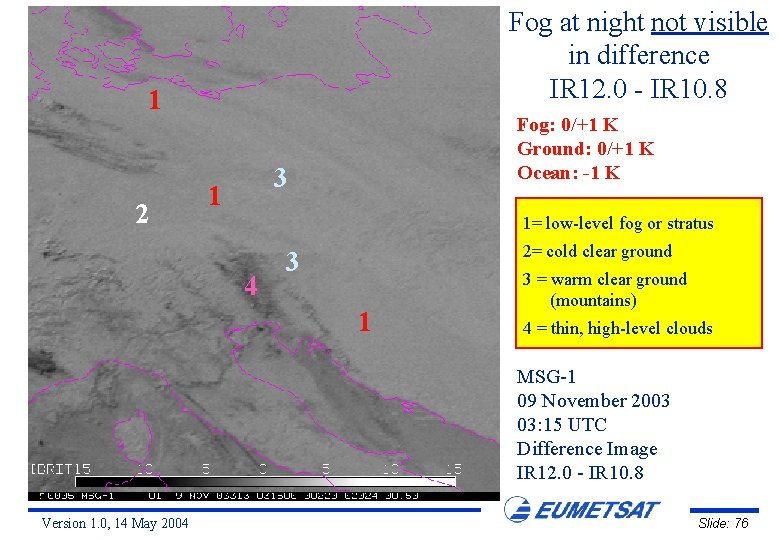
Fog at night not visible in difference IR 12. 0 - IR 10. 8 1 2 Fog: 0/+1 K Ground: 0/+1 K Ocean: -1 K 3 1 1= low-level fog or stratus 4 2= cold clear ground 3 1 3 = warm clear ground (mountains) 4 = thin, high-level clouds MSG-1 09 November 2003 03: 15 UTC Difference Image IR 12. 0 - IR 10. 8 Version 1. 0, 14 May 2004 Slide: 76

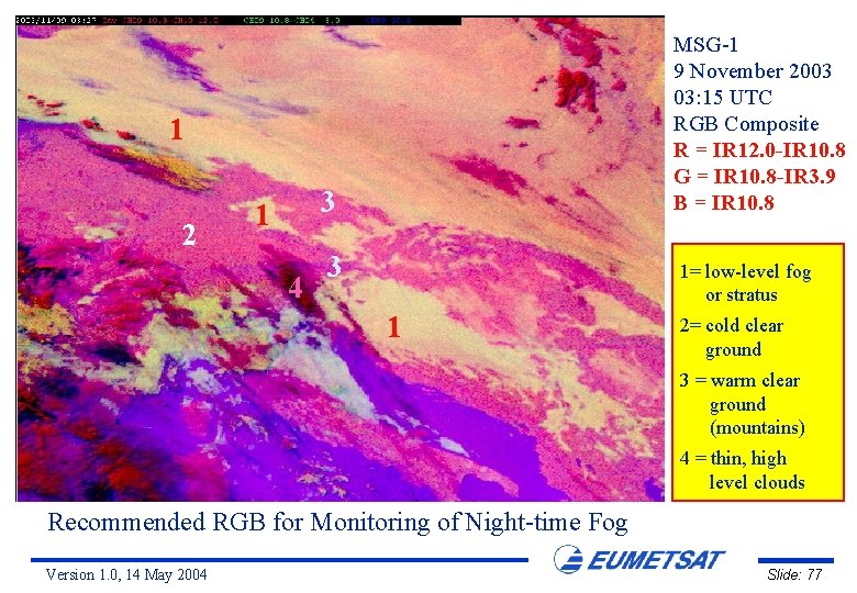
MSG-1 9 November 2003 03: 15 UTC RGB Composite R = IR 12. 0 -IR 10. 8 G = IR 10. 8 -IR 3. 9 B = IR 10. 8 1 2 3 1 4 3 1= low-level fog or stratus 1 2= cold clear ground 3 = warm clear ground (mountains) 4 = thin, high level clouds Recommended RGB for Monitoring of Night-time Fog Version 1. 0, 14 May 2004 Slide: 77

Day-time Fog over Europe 9 November 2003 Version 1. 0, 14 May 2004 Slide: 78

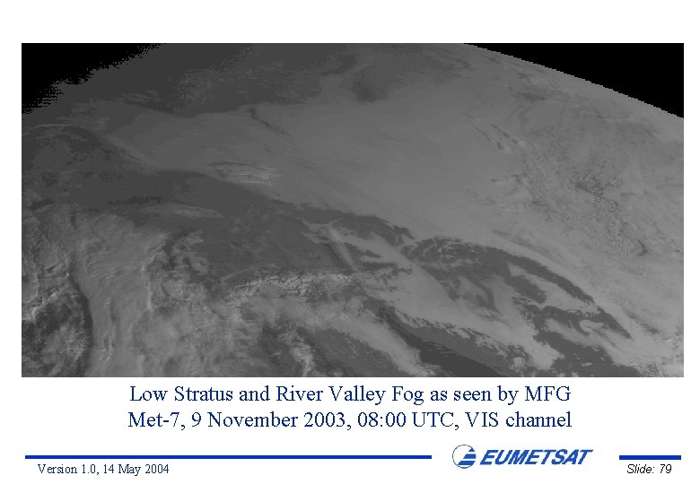
Low Stratus and River Valley Fog as seen by MFG Met-7, 9 November 2003, 08: 00 UTC, VIS channel Version 1. 0, 14 May 2004 Slide: 79

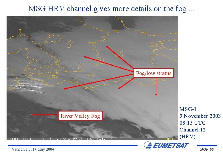
MSG HRV channel gives more details on the fog. . . Fog/low stratus River Valley Fog Version 1. 0, 14 May 2004 MSG-1 9 November 2003 08: 15 UTC Channel 12 (HRV) Slide: 80

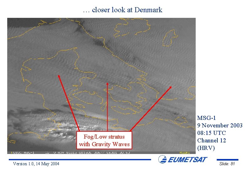
… closer look at Denmark Fog/Low stratus with Gravity Waves Version 1. 0, 14 May 2004 MSG-1 9 November 2003 08: 15 UTC Channel 12 (HRV) Slide: 81

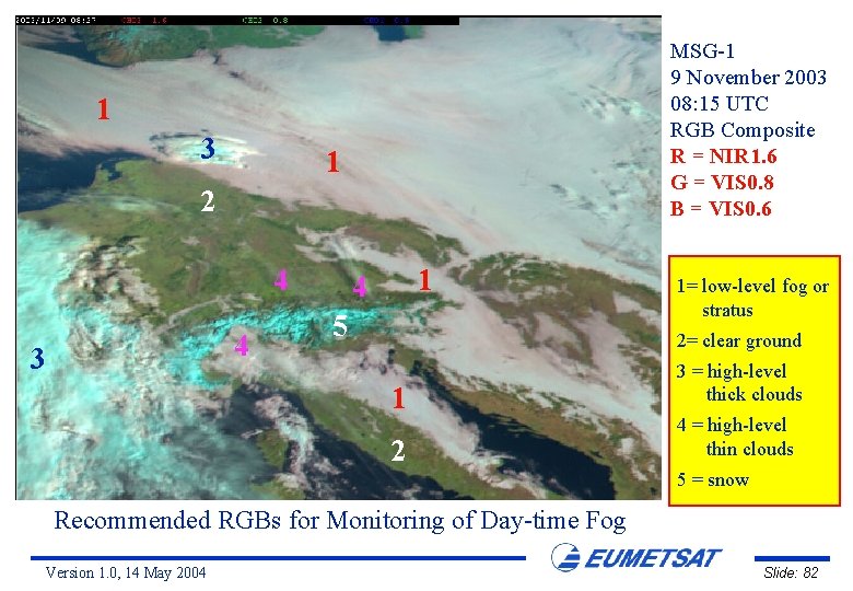
MSG-1 9 November 2003 08: 15 UTC RGB Composite R = NIR 1. 6 G = VIS 0. 8 B = VIS 0. 6 1 3 1 2 4 4 3 1 4 5 1= low-level fog or stratus 2= clear ground 1 2 3 = high-level thick clouds 4 = high-level thin clouds 5 = snow Recommended RGBs for Monitoring of Day-time Fog Version 1. 0, 14 May 2004 Slide: 82

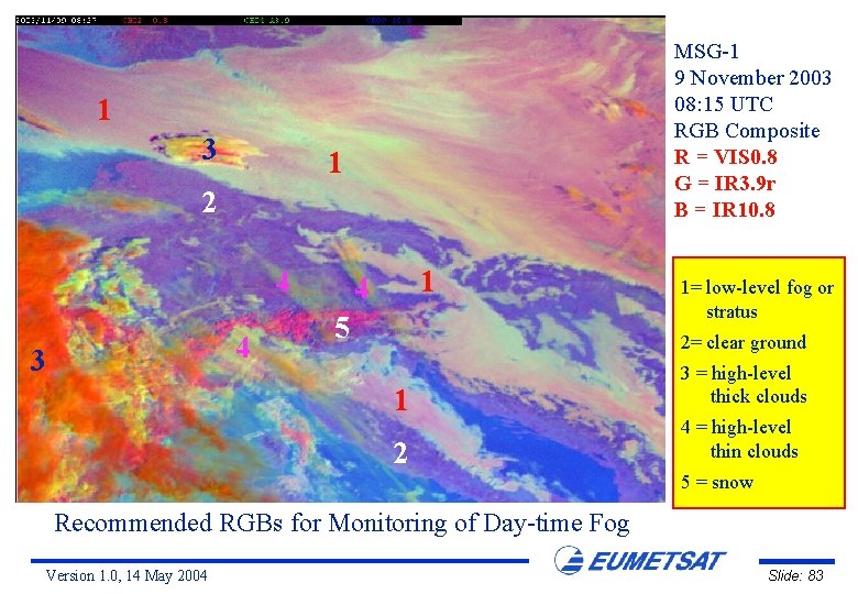
MSG-1 9 November 2003 08: 15 UTC RGB Composite R = VIS 0. 8 G = IR 3. 9 r B = IR 10. 8 1 3 1 2 4 4 3 1 4 5 1= low-level fog or stratus 2= clear ground 1 2 3 = high-level thick clouds 4 = high-level thin clouds 5 = snow Recommended RGBs for Monitoring of Day-time Fog Version 1. 0, 14 May 2004 Slide: 83

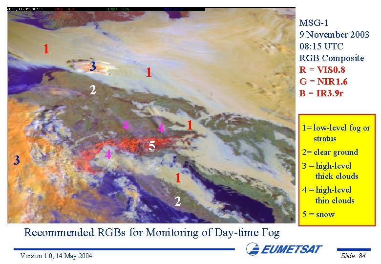
MSG-1 9 November 2003 08: 15 UTC RGB Composite R = VIS 0. 8 G = NIR 1. 6 B = IR 3. 9 r 1 3 1 2 4 4 3 1 4 5 1= low-level fog or stratus 2= clear ground 1 2 3 = high-level thick clouds 4 = high-level thin clouds 5 = snow Recommended RGBs for Monitoring of Day-time Fog Version 1. 0, 14 May 2004 Slide: 84

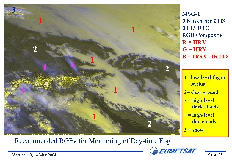
3 1 MSG-1 9 November 2003 08: 15 UTC RGB Composite R = HRV G = HRV B = IR 3. 9 - IR 10. 8 1 2 4 4 4 1 5 2 1= low-level fog or stratus 1 2= clear ground 3 = high-level thick clouds 1 2 4 = high-level thin clouds 5 = snow Recommended RGBs for Monitoring of Day-time Fog Version 1. 0, 14 May 2004 Slide: 85

Night-time Fog over Central Europe 11 November 2003 Version 1. 0, 14 May 2004 Slide: 86

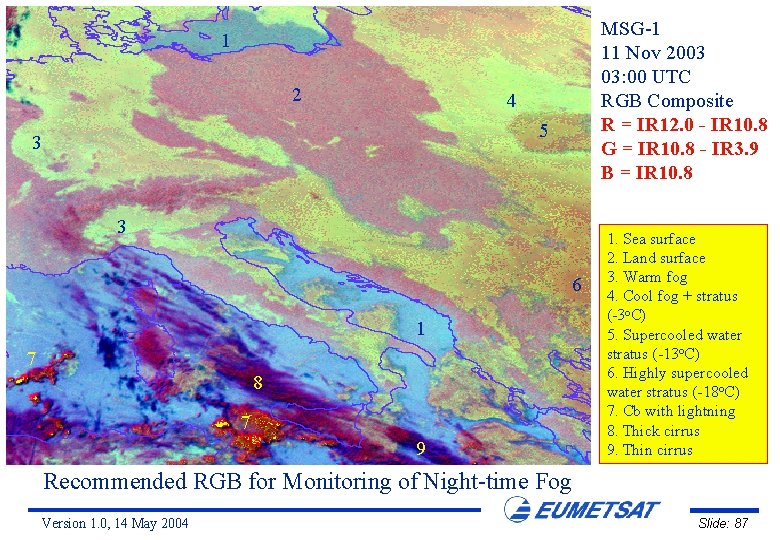
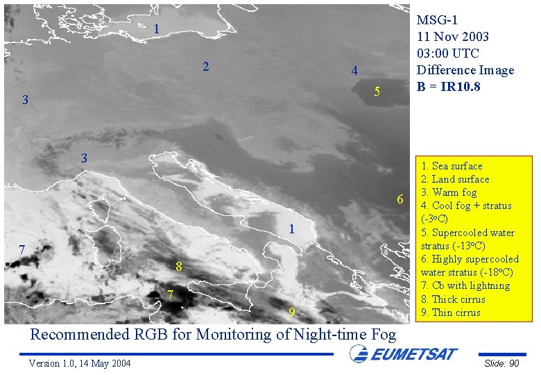
MSG-1 11 Nov 2003 03: 00 UTC RGB Composite R = IR 12. 0 - IR 10. 8 G = IR 10. 8 - IR 3. 9 B = IR 10. 8 1 2 4 5 3 3 6 1 7 8 7 9 1. Sea surface 2. Land surface 3. Warm fog 4. Cool fog + stratus (-3 o. C) 5. Supercooled water stratus (-13 o. C) 6. Highly supercooled water stratus (-18 o. C) 7. Cb with lightning 8. Thick cirrus 9. Thin cirrus Recommended RGB for Monitoring of Night-time Fog Version 1. 0, 14 May 2004 Slide: 87

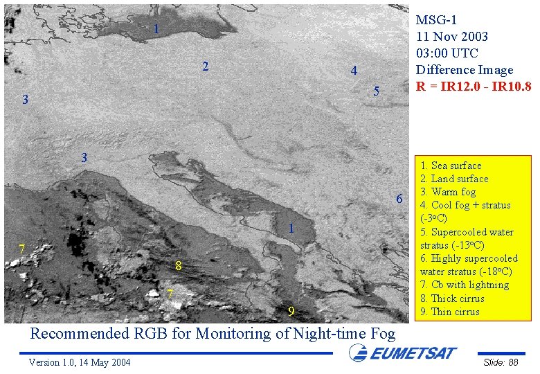
MSG-1 11 Nov 2003 03: 00 UTC Difference Image R = IR 12. 0 - IR 10. 8 1 2 4 5 3 3 6 1 7 8 7 9 1. Sea surface 2. Land surface 3. Warm fog 4. Cool fog + stratus (-3 o. C) 5. Supercooled water stratus (-13 o. C) 6. Highly supercooled water stratus (-18 o. C) 7. Cb with lightning 8. Thick cirrus 9. Thin cirrus Recommended RGB for Monitoring of Night-time Fog Version 1. 0, 14 May 2004 Slide: 88

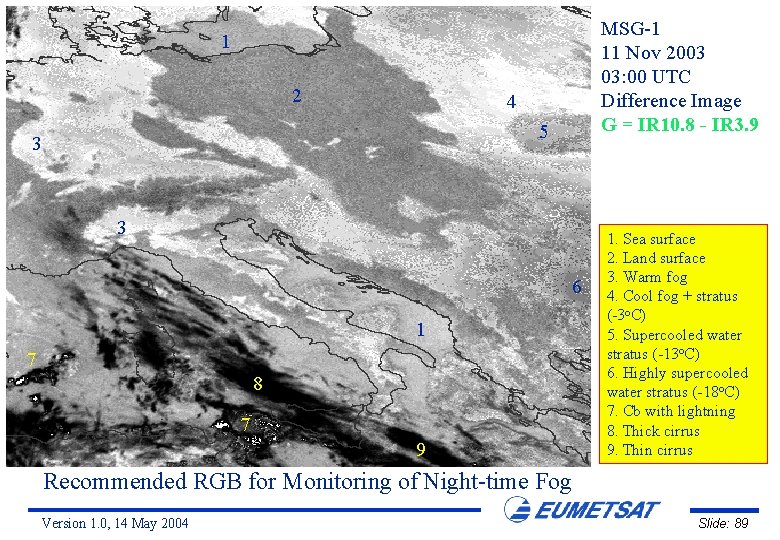
MSG-1 11 Nov 2003 03: 00 UTC Difference Image G = IR 10. 8 - IR 3. 9 1 2 4 5 3 3 6 1 7 8 7 9 1. Sea surface 2. Land surface 3. Warm fog 4. Cool fog + stratus (-3 o. C) 5. Supercooled water stratus (-13 o. C) 6. Highly supercooled water stratus (-18 o. C) 7. Cb with lightning 8. Thick cirrus 9. Thin cirrus Recommended RGB for Monitoring of Night-time Fog Version 1. 0, 14 May 2004 Slide: 89

MSG-1 11 Nov 2003 03: 00 UTC Difference Image B = IR 10. 8 1 2 4 5 3 3 6 1 7 8 7 9 1. Sea surface 2. Land surface 3. Warm fog 4. Cool fog + stratus (-3 o. C) 5. Supercooled water stratus (-13 o. C) 6. Highly supercooled water stratus (-18 o. C) 7. Cb with lightning 8. Thick cirrus 9. Thin cirrus Recommended RGB for Monitoring of Night-time Fog Version 1. 0, 14 May 2004 Slide: 90

Day-time Fog over the Po Valley 20 November 2003 Version 1. 0, 14 May 2004 Slide: 91

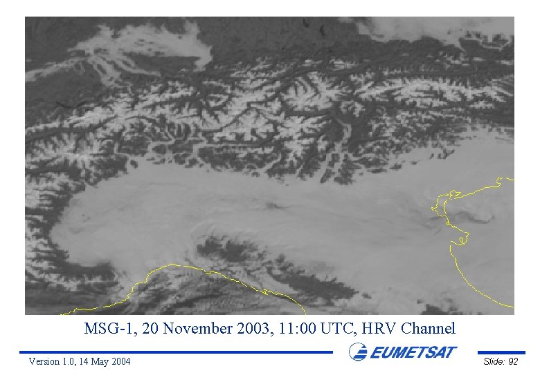
MSG-1, 20 November 2003, 11: 00 UTC, HRV Channel Version 1. 0, 14 May 2004 Slide: 92

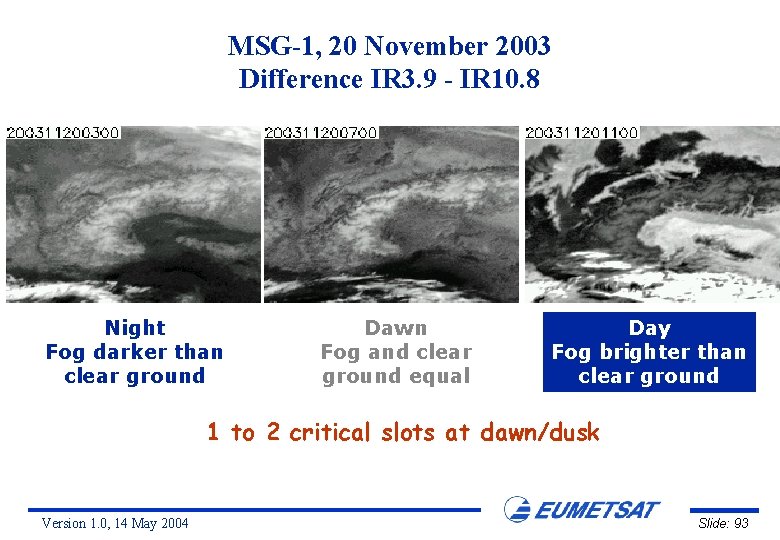
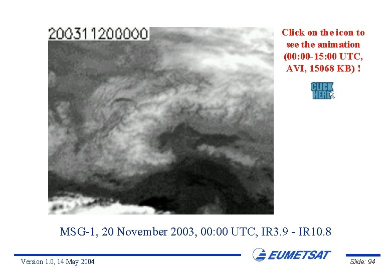
MSG-1, 20 November 2003 Difference IR 3. 9 - IR 10. 8 Night Fog darker than clear ground Dawn Fog and clear ground equal Day Fog brighter than clear ground 1 to 2 critical slots at dawn/dusk Version 1. 0, 14 May 2004 Slide: 93

Click on the icon to see the animation (00: 00 -15: 00 UTC, AVI, 15068 KB) ! MSG-1, 20 November 2003, 00: 00 UTC, IR 3. 9 - IR 10. 8 Version 1. 0, 14 May 2004 Slide: 94

SUMMARY Version 1. 0, 14 May 2004 Slide: 95

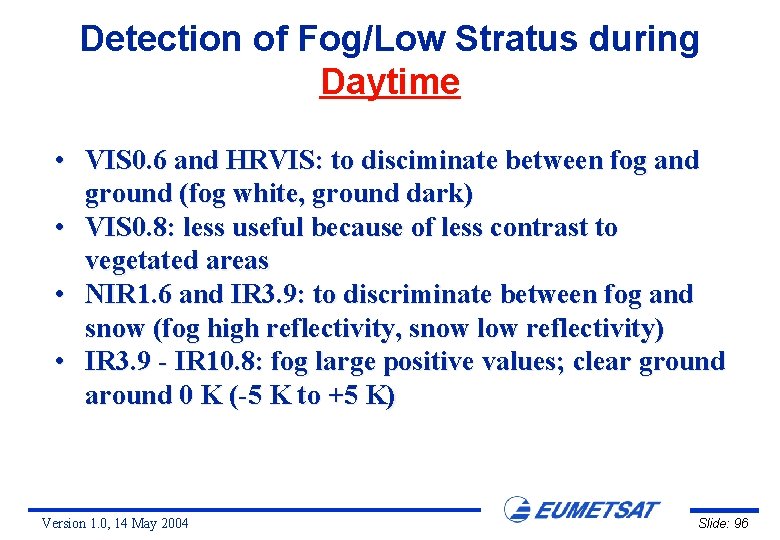
Detection of Fog/Low Stratus during Daytime • VIS 0. 6 and HRVIS: to disciminate between fog and ground (fog white, ground dark) • VIS 0. 8: less useful because of less contrast to vegetated areas • NIR 1. 6 and IR 3. 9: to discriminate between fog and snow (fog high reflectivity, snow low reflectivity) • IR 3. 9 - IR 10. 8: fog large positive values; clear ground around 0 K (-5 K to +5 K) Version 1. 0, 14 May 2004 Slide: 96

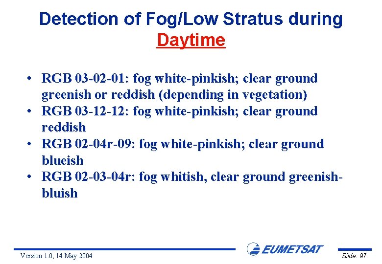
Detection of Fog/Low Stratus during Daytime • RGB 03 -02 -01: fog white-pinkish; clear ground greenish or reddish (depending in vegetation) • RGB 03 -12 -12: fog white-pinkish; clear ground reddish • RGB 02 -04 r-09: fog white-pinkish; clear ground blueish • RGB 02 -03 -04 r: fog whitish, clear ground greenishbluish Version 1. 0, 14 May 2004 Slide: 97

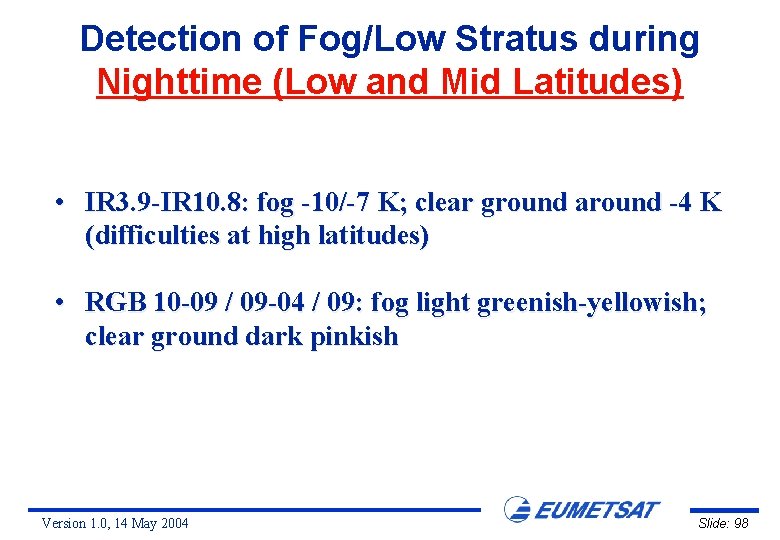
Detection of Fog/Low Stratus during Nighttime (Low and Mid Latitudes) • IR 3. 9 -IR 10. 8: fog -10/-7 K; clear ground around -4 K (difficulties at high latitudes) • RGB 10 -09 / 09 -04 / 09: fog light greenish-yellowish; clear ground dark pinkish Version 1. 0, 14 May 2004 Slide: 98

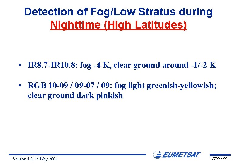
Detection of Fog/Low Stratus during Nighttime (High Latitudes) • IR 8. 7 -IR 10. 8: fog -4 K, clear ground around -1/-2 K • RGB 10 -09 / 09 -07 / 09: fog light greenish-yellowish; clear ground dark pinkish Version 1. 0, 14 May 2004 Slide: 99

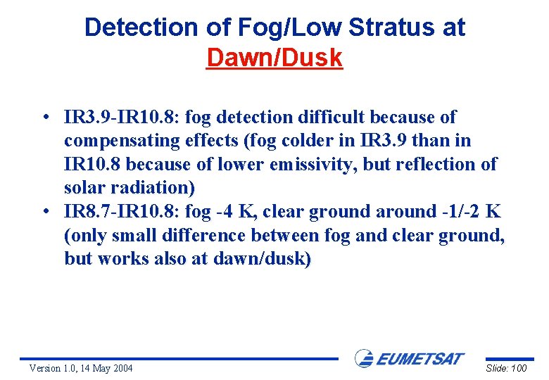
Detection of Fog/Low Stratus at Dawn/Dusk • IR 3. 9 -IR 10. 8: fog detection difficult because of compensating effects (fog colder in IR 3. 9 than in IR 10. 8 because of lower emissivity, but reflection of solar radiation) • IR 8. 7 -IR 10. 8: fog -4 K, clear ground around -1/-2 K (only small difference between fog and clear ground, but works also at dawn/dusk) Version 1. 0, 14 May 2004 Slide: 100

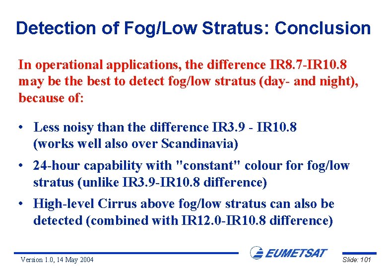
Detection of Fog/Low Stratus: Conclusion In operational applications, the difference IR 8. 7 -IR 10. 8 may be the best to detect fog/low stratus (day- and night), because of: • Less noisy than the difference IR 3. 9 - IR 10. 8 (works well also over Scandinavia) • 24 -hour capability with "constant" colour fog/low stratus (unlike IR 3. 9 -IR 10. 8 difference) • High-level Cirrus above fog/low stratus can also be detected (combined with IR 12. 0 -IR 10. 8 difference) Version 1. 0, 14 May 2004 Slide: 101

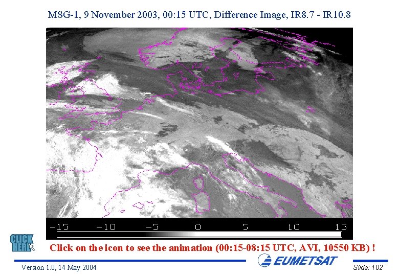
MSG-1, 9 November 2003, 00: 15 UTC, Difference Image, IR 8. 7 - IR 10. 8 Click on the icon to see the animation (00: 15 -08: 15 UTC, AVI, 10550 KB) ! Version 1. 0, 14 May 2004 Slide: 102