
Application of tsunami modelling for escape and refuge


- Slides: 24
Application of tsunami modelling for escape and refuge planning in Aceh (Indonesia) Odelinde Nieuwenhuis, DHV BV Deepak Vatvani, Deltares (Delft Hydraulics) Jeroen Alberts, DHV BV Dick Jansen, DHV BV May 2008
Tsunami 2004 event Ø 9. 2 MW extreme earthquake west of Sumatra, resulting in tsunami wave propagating in different directions ØDevastating effect on surrounding countries Pre-tsunami coastlin Pre tsunami coastline Vegetation and houses destructed Coastline erosion Before tsunami After tsunami
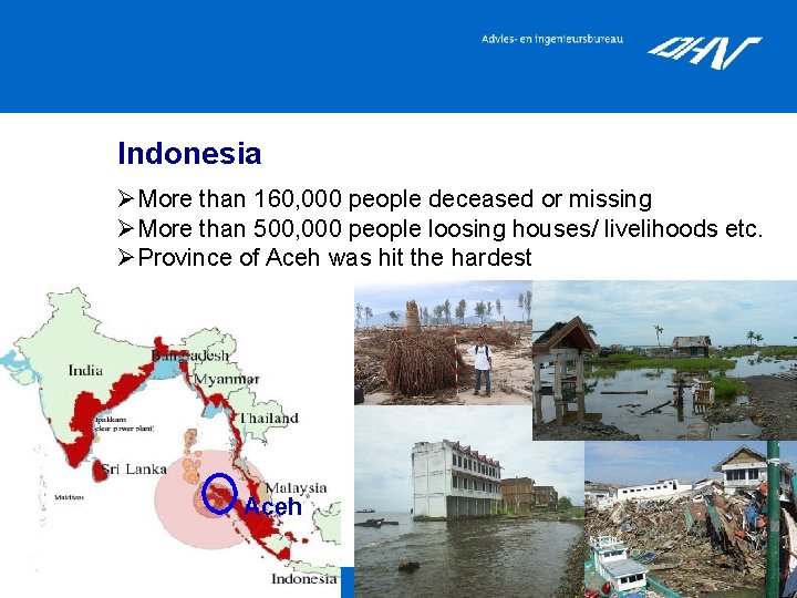
Indonesia ØMore than 160, 000 people deceased or missing ØMore than 500, 000 people loosing houses/ livelihoods etc. ØProvince of Aceh was hit the hardest Aceh
Presentation outline 1. Introduction SDC Project 2. Tsunami inundation modelling 3. Flood hazard mapping 4. Escape and refuge planning 5. Follow-up and conclusions
1. 2. 3. 4. 5. Introduction (1/11) Tsunami inundation modelling Flood hazard mapping Escape and refuge planning Follow-up and conclusions SDC Project ØSea Defence, Flood Protection, Refuge and Early Warning System Project (SDC Project) ØDutch/ Indonesian consortium lead by DHV Group (other Dutch partners: Witteveen + Bos, Deltares) ØPrimary development objectives: -put in place an appropriate strategy for sea defence, flood protection, multifunctional refuge facilities and a regional early warning system -provide design guidelines for such systems Important consideration: resettlement in high risk coastal areas!
1. 2. 3. 4. 5. Introduction (2/11) Tsunami inundation modelling Flood hazard mapping Escape and refuge planning Follow-up and conclusions Focus of presentation ØSDC’s objectives require more insight in flood risk: Set up of tsunami inundation models and creation of flood hazard maps Ø Various uses of flood hazard maps in SDC project: • Spatial planning purposes (focus on saving lives; escape and refuge planning) • Warning system (database of hazard maps) • Detailed damage and risk assessment • Assessment effectiveness and cost benefit analysis tsunami protection measures • Increased understanding propagation tsunami wave and resulting coastal flooding
1. 2. 3. 4. 5. Introduction (2/11) Tsunami inundation modelling Flood hazard mapping Escape and refuge planning Follow-up and conclusions presentation Focus of presentation ØSDC’s objectives require more insight in flood risk: Set up of tsunami inundation models and creation of flood hazard maps Ø Various uses of flood hazard maps in SDC project: • Spatial planning purposes (focus on saving lives; escape and refuge planning) • Warning system (database of hazard maps) • Detailed damage & casualties + risk assessment • Assessment effectiveness and cost benefit analysis tsunami protection measures • Understanding propagation tsunami wave and resulting coastal flooding
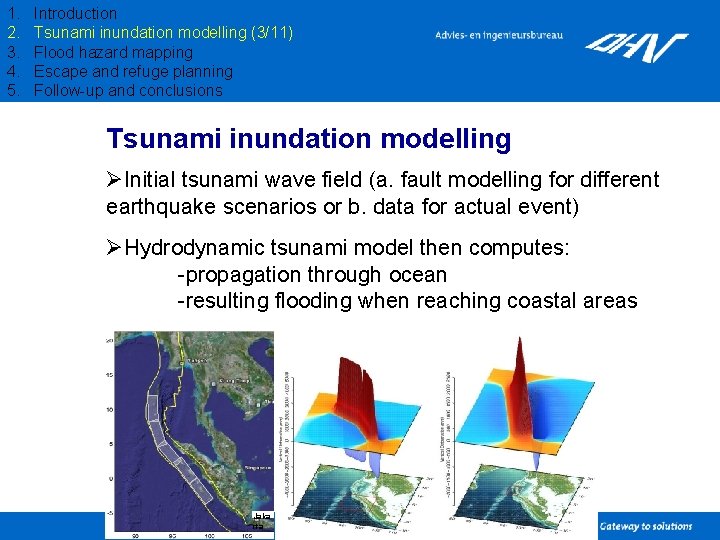
1. 2. 3. 4. 5. Introduction Tsunami inundation modelling (3/11) Flood hazard mapping Escape and refuge planning Follow-up and conclusions Tsunami inundation modelling ØInitial tsunami wave field (a. fault modelling for different earthquake scenarios or b. data for actual event) ØHydrodynamic tsunami model then computes: -propagation through ocean -resulting flooding when reaching coastal areas Jaka rta
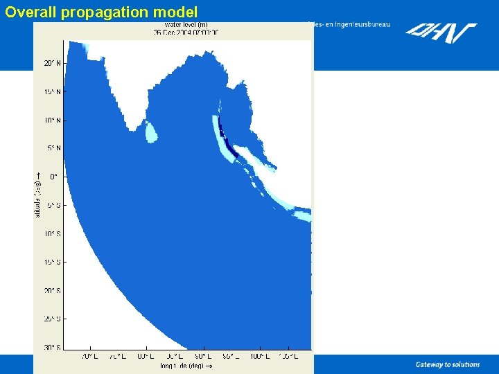
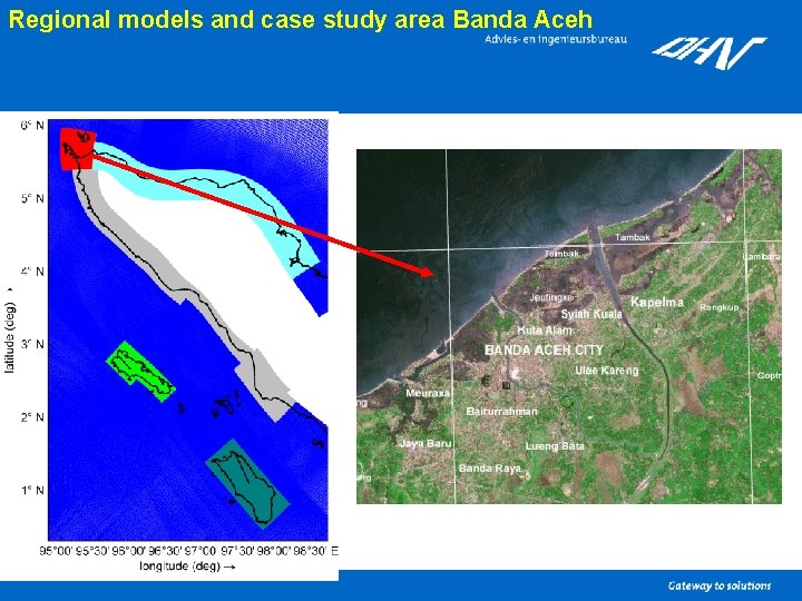
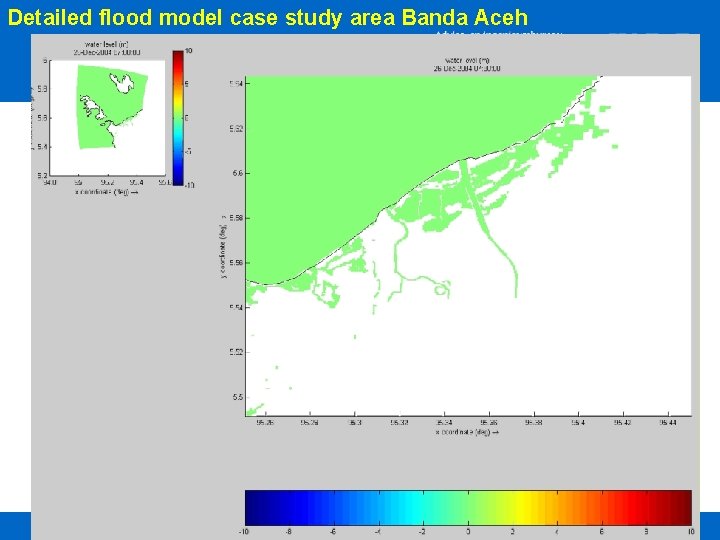
1. 2. 3. 4. 5. Introduction Tsunami inundation modelling (4/11) Flood hazard mapping Escape and refuge planning Follow-up and conclusions SDC inundation models ØExisting tsunami inundation models (Delft 3 D software, set up by project partner Deltares) showed: • good simulation of overall tsunami inundation patterns • improvement required for detailed patterns ØExisting models were refined (grid resolution, more detailed bathymetry and topography data) ØResulting in new set of SDC inundation models: -1 overall propagation model, 1000 m resolution -5 regional flooding models, 200 m resolution -1 detailed flooding model case study area Banda Aceh, 50 m resolution
Overall propagation model
Regional models and case study area Banda Aceh
Detailed flood model case study area Banda Aceh
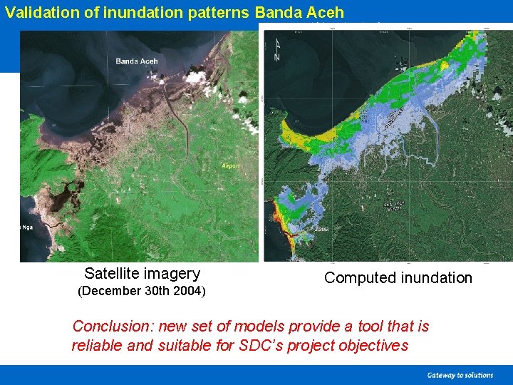
1. 2. 3. 4. 5. Project background Tsunami inundation modelling (5/11) Flood hazard mapping Escape and refuge planning Follow-up and conclusions Validation model results Validation only possible for December 2004 event: ØWave heights at sea, these were validated and found to be accurately simulated for existing models by Deltares (Vatvani, 2005) ØInundation patterns and depths were analysed based on satellite pictures (presence vegetation), eyewitness reports and measured values by survey teams. Computated inundation with refined models turned out to agree very well with actual inundation, patterns as well as depth.
Validation of inundation patterns Banda Aceh Satellite imagery (December 30 th 2004) Computed inundation Conclusion: new set of models provide a tool that is reliable and suitable for SDC’s project objectives
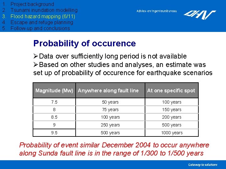
1. 2. 3. 4. 5. Project background Tsunami inundation modelling Flood hazard mapping (6/11) Escape and refuge planning Follow-up and conclusions Probability of occurence ØData over sufficiently long period is not available ØBased on other studies and analyses, an estimate was set up of probability of occurence for earthquake scenarios Magnitude (Mw) Anywhere along fault line At one specific spot 7. 5 50 years 100 years 8 75 years 150 years 8. 5 100 years 200 years 9 250 years 500 years 9. 5 500 years 1000 years Probability of event similar December 2004 to occur anywhere along Sunda fault line is in the range of 1/300 to 1/500 years
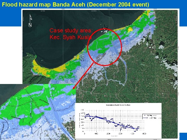
1. 2. 3. 4. 5. Project background Tsunami inundation modelling Flood hazard mapping (7/11) Escape and refuge planning Follow-up and conclusions Flood hazard maps ØOver 300 computations executed up to now for creation of database flood hazard maps (for different earthquake scenarios; varying location, strength, focal depth, dip angle) ØInitial design condition for escape and refuge planning: December 2004 event flood hazard map
Flood hazard map Banda Aceh (December 2004 event) Case study area: Kec. Syah Kuala
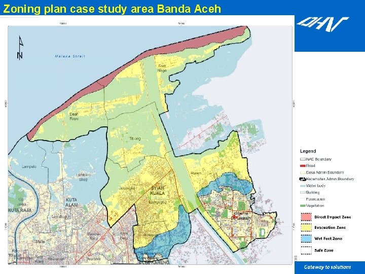
1. 2. 3. 4. 5. Project background Tsunami inundation modelling Flood hazard mapping Escape and refuge planning (8/11) Follow-up and conclusions Zoning plan Based on the flood hazard map and inundation depths, impact areas are defined for planning purposes: ØDirect impact zone; survival rate minimum, only specifically designed buildings will remain standing ØEvacuation zone; evacuation required, only solid engineered structures will remain standing ØWet feet zone; debris remains a threat to human lives, most normal structures will remain standing ØSafe zone; no impact
Zoning plan case study area Banda Aceh
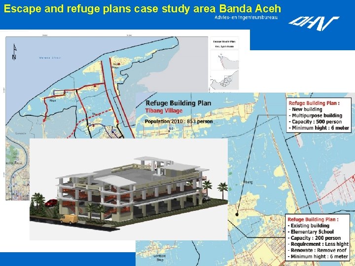
1. 2. 3. 4. 5. Project background Tsunami inundation modelling Flood hazard mapping Escape and refuge planning (9/11) Follow-up and conclusions Escape and refuge plans Based on the zoning plan and spatial data (population figures, road maps, inventory of buildings), more detailed escape and refuge plans are set up: ØEscape capacity plan ØRefuge facility plan ØEscape route plan ØWarning plan Note: People are resettling in high risk areas in Banda Aceh, where fatality rates are expected to be 60 -70%. Escape and refuge plans very important and therefore have been set up for all high risk areas.
Escape and refuge plans case study area Banda Aceh
1. 2. 3. 4. 5. Project background Tsunami inundation modelling Flood hazard mapping Escape and refuge planning Follow-up and conclusions (10/11) Follow-up Sumatra ØCollaboration has been set up with universities Sumatra; training and support in further development of model. First target: expanding tsunami model for entire high risk area Sumatra west coast (completion in 2009). Possible follow up: set up of escape and refuge plans for these areas.
1. 2. 3. 4. 5. Project background Tsunami inundation modelling Flood hazard mapping Escape and refuge planning Follow-up and conclusions (11/11) General conclusions ØThe SDC tsunami inundation models has proven to be a reliable tool and suitable for detailed risk assessment and spatial planning purposes. ØA general stepwise methodology translating flood hazard maps to detailed escape and refuge plans has been set up and can be used in other areas. Similar regional tsunami inundation models and the presented stepwise methodology can be applied in other countries surrounding the Indian Ocean.
Thank you for your attention Questions?