Application of a HighPulseRate LowPulseEnergy Doppler Lidar for


 1. 6 2. 0 PRF")


 More near-surface turbulence detail 96 gates x")


 Langford et al, GRL, submitted")


- Slides: 22
Application of a High-Pulse-Rate, Low-Pulse-Energy Doppler Lidar for Airborne Pollution Transport Measurement Mike Hardesty 1, 4, Sara Tucker 4*, Guy Pearson 2, 3, Fay Davies 3, Raul Alvarez II 1, Christoph Senff 4, and Richard Marchbanks 4 1 NOAA Earth System Research Laboratory, Boulder, CO, USA 2 Halo Photonics, Great Malvern, U. K. , 3 University of Salford, U. K. 4 Cooperative Institute for Research in Environmental Sciences Boulder, CO, USA *now with Ball Aerospace
Overview • Objective: co-deploy a Doppler lidar with ozone lidar and AMAXDOAS on an aircraft for pollution studies • Which Doppler lidar to use? • Ground-based comparisons of an off the shelf Doppler instrument with a research lidar • Aircraft deployment tests (summer 2009) • Future plans
Background • NOAA has a goal to improve air quality forecasting with major field campaigns to characterize air quality in different regions • Field observations include DIAL ozone profiles and DOAS NO 2 column from a Twin Otter aircraft to observe 3 -D regional ozone distribution • Better wind information is needed to determine transport of pollutants, particularly in complex terrain • Goal: study feasibility of adding a Doppler lidar to the Twin Otter to measure horizontal fluxes
AMAX DOAS Measurements of NO 2 slant column density below aircraft NADIR telescope, QE 65000 spectrometer #2, 5 sec data NO 2 enhancements downwind of Denver / over foothills Expanded inset (from the left): NO 2 plume downwind of the Cherokee power plant
Previous airborne lidar measurements of species transport • Demonstrated capability of codeploying lidar for species transport during 2002 IHOP campaign • Installed NOAA high resolution Doppler lidar with DLR water vapor DIAL on the DLR Falcon • Measured vertical and horizontal transport of water vapor in the boundary layer • Goal: duplicate this measurement with ozone DIAL • Problem: No room for HRDL on the NOAA Twin Otter • Proposed solution: Compact commercial lidar (Halo Photonics) DIAL/Doppler lidar (1500 m spacing)
Experiment objectives • Characterize the Halo Photonics Doppler lidar by comparing with HRDL • Install the Halo lidar on the Twin Otter • Evaluate the ability of the lidar to operate in the aircraft environment • Evaluate sensitivity for boundary layer measurements for operation at 3 -4 km flight altitudes • Demonstrate combined ozone and wind measurements
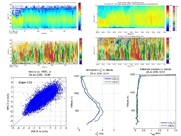
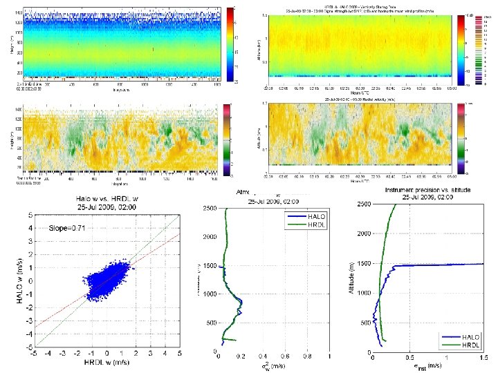
HRDL/Halo Comparison Halo HRDL Detection type coherent Wavelength (µm) 1. 6 2. 0 PRF (Hz) 20 , 000 200 Pulse Energy µJ m. J Aperture (cm) 7. 5 10 Range gate (m) variable 30 • Operated for nearly 24 hours • Two modes: vertically and nearly horizontally pointing • Compare instantaneous velocity measurements with same averaging time (~1 -2 s)
HRDL 1400 m max alt. Halo Lidar
In situ temperature and humidity
Halo Lidar Likely precip (drizzle, virga? ) More near-surface turbulence detail 96 gates x 50 m, averaging over <30000> pulses 27% duty cycle HRDL
Installing the Halo instrument • No optical port was available, so Halo shared a port with the ozone lidar • Halo mounted looking transverse to the aircraft at 30 degrees off nadir • Velocity correction for aircraft motion computed from ground return
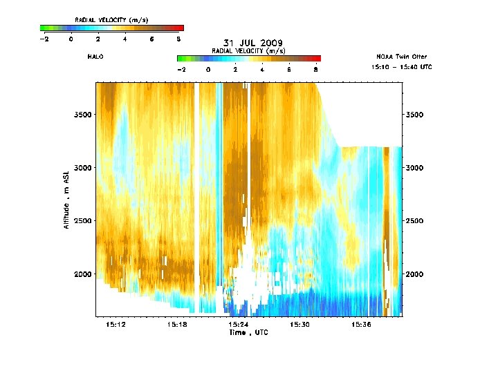
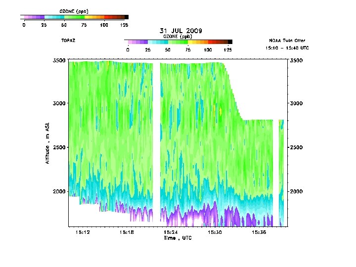
Flight test • Two flight tests of codeployed Doppler and ozone • Weather was uncooperative: cool and cloudy • Second test aimed at investigating Denver plume and power plant plumes to the NE • Very little ozone above background Flux profile Profiler
Wind component on NE-SW leg
Ozone concentration on NE-SW leg
Horizontal ozone fluxes • Ozone flux component computed for every measurement point • Provided measurements with 500 m horizontal, 90 m vertical resolution 3000 3500 2800 2600 2500 Wind Profiler 15: 00 2000 Halo Lidar Wind profiler 16: 00 1500 2400 2200 2000 1800 1600 1000 -2 Altitude (m ASL) 3000 1400 0 2 4 6 Wind component (m s-1) 8 10 0 100 200 300 400 Transverse Ozone flux (ppb m s-1) 500
California ozone transport From Lu and Turco (1966) Langford et al, GRL, submitted
Measure 3 -D winds and fluxes in CALNEX • Install a wedge scanner into the Twin Otter • Implement a 3 -point scan (two orthogonal horizontal and one vertical) • Compute a 3 -dimensional wind vector with 500 m horizontal , 30 m vertical resolution • Combine ozone and wind measurements to estimate ozone transport 45°
Summary • Halo measurements compared well with HRDL , showing small scale structure and reasonable correlation • The Halo lidar operated well in the Twin Otter aircraft, showing minimal effects from vibration and temperature fluctuations • Sensitivity of the Halo instrument appeared to be adequate for characterization of the full boundary layer from 3 -4 km • Demonstrated a capability to measure ozone transport profiles at 500 m horizontal resolution • Next application : 3 -D winds and ozone fluxes over Southern California (summer 2010) • Hope to apply the small lidar for boundary layer ADM cal-val