Application 2 Detect Filarial Worms Source Skeleton BTT

Application 2 Detect Filarial Worms Source Skeleton BTT Eliminate short structures Remove Noises Reconstruction Threshold Final result
 is • based on Recursive Erosion operation. “Keep")
Ultimate Erosion • Ultimate Erosion (UE) is • based on Recursive Erosion operation. “Keep aside each connected components just before it is removed throughout the recursive erosion process”.
 is based on • Recursive Dilation operation with")
Geodesic Influence • Geodesic Influence (GI) is based on • Recursive Dilation operation with mask which also called conditional dilation. Reconstruct the seeds by the restriction of the mask, and distribute the pixels on the interface by means of “first come first serve”.
")
UE and GI • UE: split a connected • region (have to be convex) gradually and record the iteration number. GI: Reconstruct the split regions and get the segments.

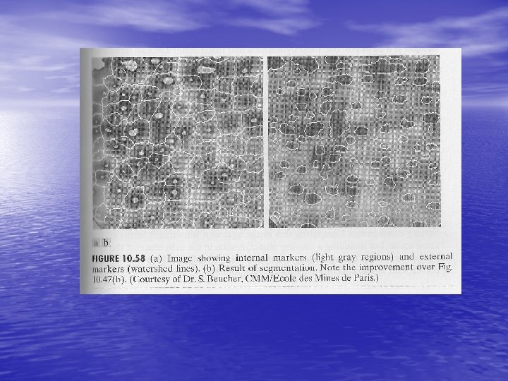
Application • Segment connected organs: 1. RE: region shrinking to generate all the candidate seeds 2. GI: region reconstruction to recover separated organs
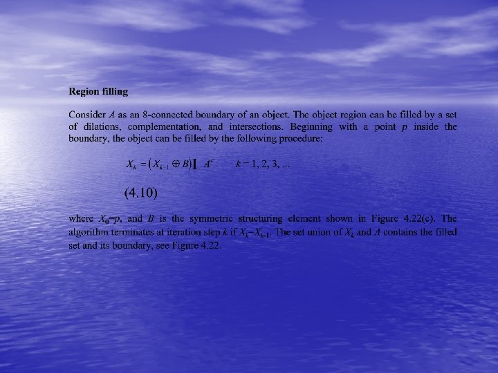
 boundary of an object; (b) complement of the")
Figure 4. 22: Region filling: (a) boundary of an object; (b) complement of the boundary; (c) structuring element(d) initial point inside the boundary; (e)-(h) various steps of the algorithm; (i) final result, obtained by forming the set union of (a) and (h).

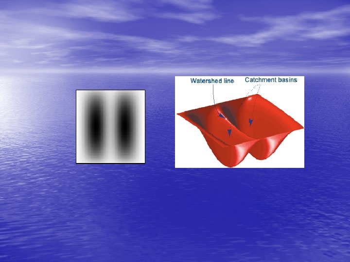
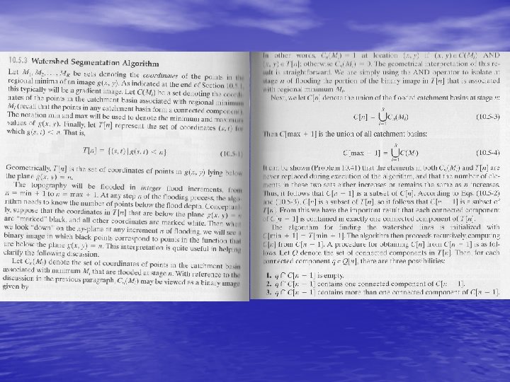
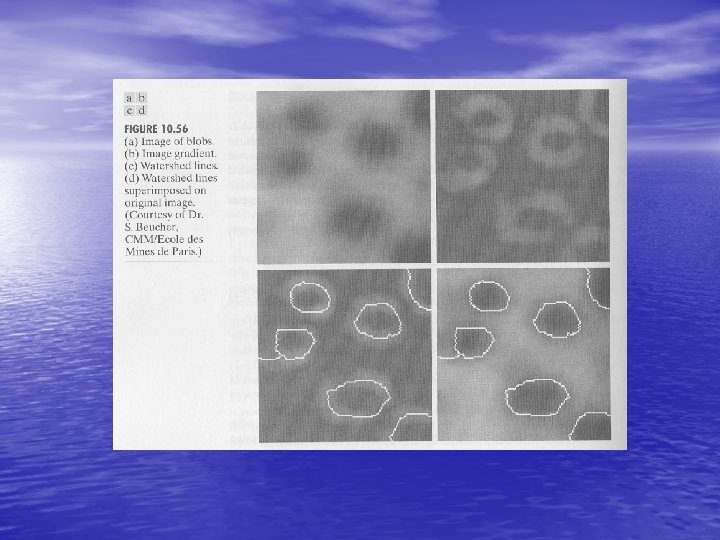
Watershed transform • A grey-level image may be seen as a topographic relief, where the grey level of a pixel is interpreted as its altitude in the relief. • A drop of water falling on a topographic relief flows along a path to finally reach a local minimum. • Intuitively, the watershed of a relief correspond to the limits of the adjacent catchment basins of the drops of water. Cardiac MRI image Gradient image Relief of the gradient Watershed of the gradient (relief)

GENERAL DEFINITION A drainage basin or watershed is an extent or an area of land where surface water from rain melting snow or ice converges to a single point at a lower elevation, usually the exit of the basin, where the waters join another waterbody, such as a river, lake, wetland, sea, or ocean 11

INTRODUCTION v. The Watershed transformation is a powerful tool for image segmentation, it uses the region-based approach and searches for pixel and region similarities. v. The watershed concept was first applied by Beucher and Lantuejoul at 1979, they used it to segment images of bubbles and SEM metallographic pictures 12

IMAGE REPRESENTATION • 13

REMINDER-IMAGE GRADIENT An image gradient is a directional change in the intensity or color in an image. Image gradients may be used to extract information from images. 14

IMAGE GRADIENT an intensity image a gradient image in the x a gradient image in the y direction measuring horizontal change in vertical change in intensity 15

IMAGE GRADIENT • 16

GEODESIC DISTANCE 17

GEODESIC ZONE OF INFLUENCE • 18

GEODESIC SKELETON BY ZONES OF INFLUENCE 19

MINIMA AND MAXIMA 20

MINIMA AND MAXIMA • 21

ASCENDING PATH 22

NON-ASCENDING PATH 23

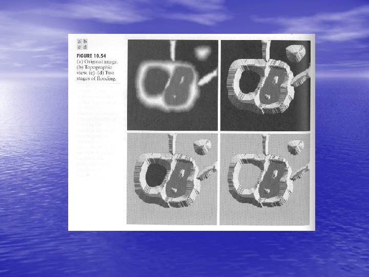
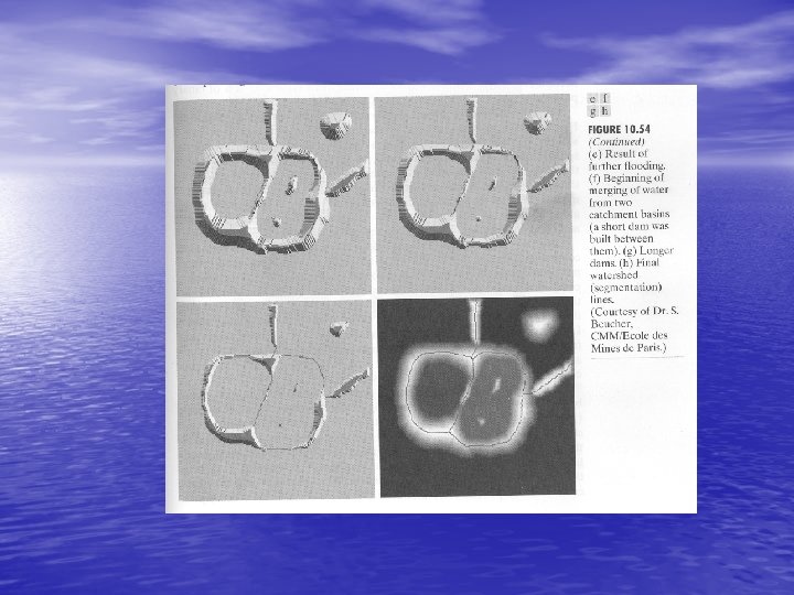
THE WATERSHED TRANSFORMATION 24

THE WATERSHED TRANSFORMATIO N 25

THE WATERSHED TRANSFORMATIO N Øhttp: //cmm. ensmp. fr/~beucher/lpe 1. gif 26

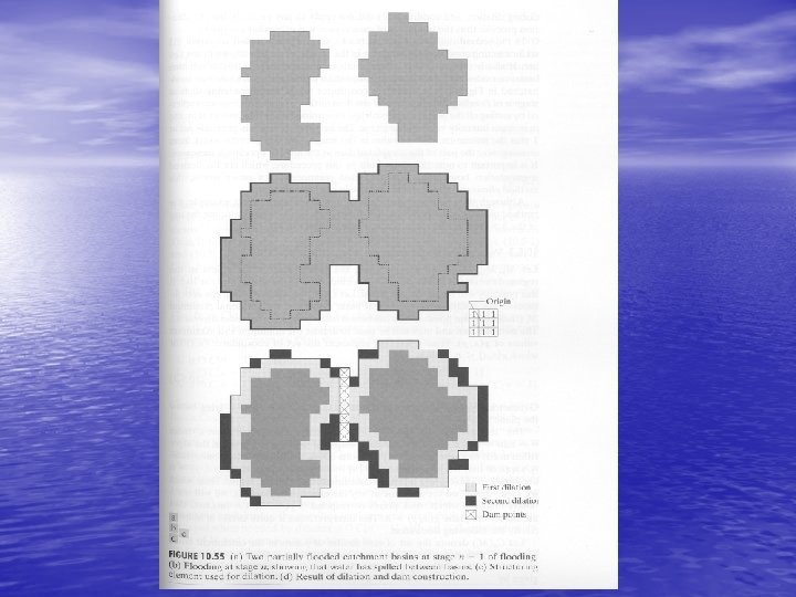
BUILDING THE WATERSHED • 27

BUILDING THE WATERSHED 28

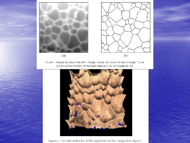
BUILDING THE WATERSHED • Ø Visual illustration 29
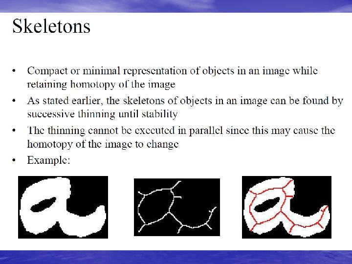

Skeletonization

Skeleton by distance transforms Maxima of distance transform
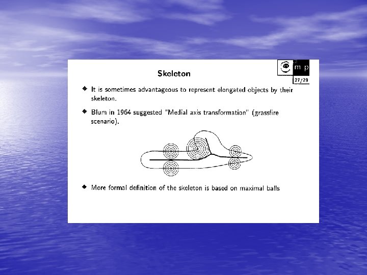
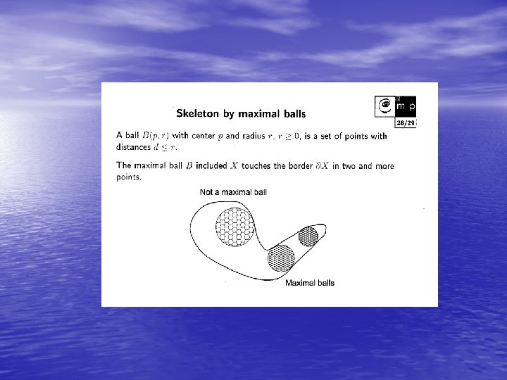
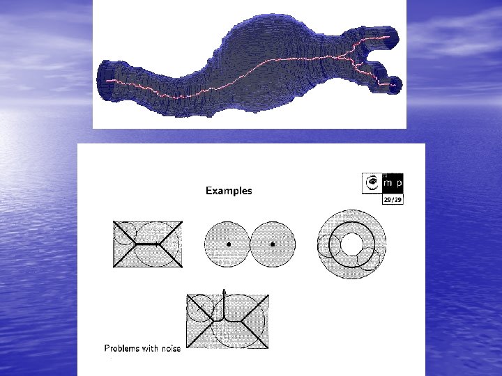
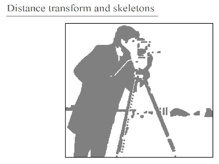
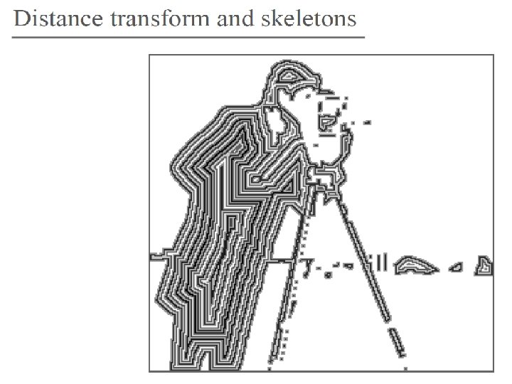
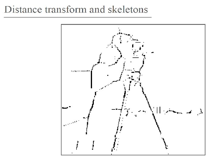
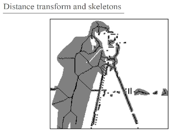

Distance Transform

Skeleton Reconstruction: the original object can be reconstructed by given knowledge of the skeleton subsets Si(F), the SE K, and i: Examples of skeleton:
")
The Distance Transform on Curved Space (DTOCS)
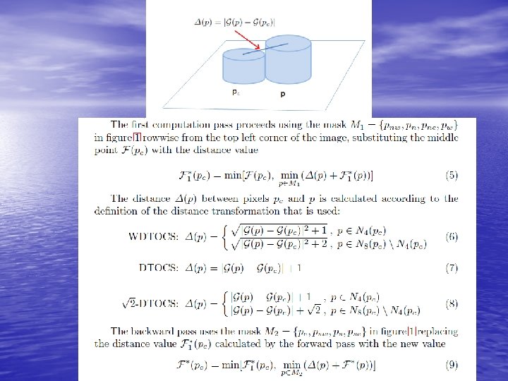
 • Calculates minimal distances between 2 points along")
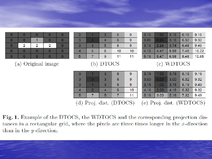
Distance Transform on Curved Space (DTOCS) • Calculates minimal distances between 2 points along a curved surface • Calculates minimal distances between areas and areas/points on curved surface • Uses a 3 x 3 calculation kernel with different metrics: • Chessboard • City block • Is a gray-level extension to the Rosenfeldt-Pfaltz-Lay algorithm (which calculates a distance transform for binary images) • Presented by Toivanen and Vepsäläinen in 1991 and 1993. • Applications: • Texture feature extraction and classification (e. g. paper roughness) (Kuparinen and Toivanen 2006, 2007) • Shortest distance calculations (Ikonen and Toivanen 2006) • Image compression
 • Calculates minimal distances between 2 points")
Weighted Distance Transform on Curved Space (WDTOCS) • Calculates minimal distances between 2 points along a curved surface • Calculates minimal distances between areas and areas/points on curved surface • Uses a 3 x 3 calculation kernel with different metrics: • Chessboard • City block • Measures the differences between adjacent pixels by their Euclidean distance + (1 or 1, 4 for the xy-surface displacement) • Presented by Toivanen and Vepsäläinen in 1991 and 1993. • Applications: • Texture feature extraction and classification (e. g. paper roughness) (Kuparinen and Toivanen 2006, 2007) • Shortest distance calculations (Ikonen and Toivanen 2006) • Image compression
")
Definition of the Distance Transform On Curved Space (DTOCS)

The 3 x 3 kernel used in DTOCS algorithm pne pn pne pw pc pe psw ps pse

The 3 x 3 kernel used in DTOCS algorithm pne pn pne pw pc pe psw ps pse
")
The Distance Transform on Curved Space (DTOCS)

Original image Distance image after forward pass

Distance image after backward pass Distance image after 2 nd iteration (= forward+backward pass second time)

Original Lena image 521 x 8 bits Curves in which DTOCS distance > binary distance Control points chosen along the curves
 LWC (d) LWC (b) SC (c) Cardboard (e) SC (f) Cardboard")
(a) LWC (d) LWC (b) SC (c) Cardboard (e) SC (f) Cardboard


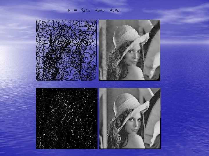
Shortest route calculation with Route DTOCS.

Original image a b

a b Shortest route between a and b
 Original image, b) distance from source point, c) distance from destination")
Fig. 2. a) Original image, b) distance from source point, c) distance from destination point, d) sum of distance images, e) route by DTOCS, f) route by WDTOCS.

Original labyrinth Shortest routes by DTOCS

Original labyrinth Shortest routes by DTOCS

The End
- Slides: 81