An overview DR MONIQUE MACKENZIE PROF NORMAN OWENSMITH

 Some")


- Slides: 20
An overview DR MONIQUE MACKENZIE & PROF NORMAN OWEN-SMITH CENTRE FOR RESEARCH INTO ECOLOGICAL AND ENVIRONMENTAL MODELLING (CREEM) SENIOR LECTURER IN MATHEMATICS AND STATISTICS UNIVERSITY OF ST ANDREWS, UK
The next few minutes Objectives of the meeting Ideal outcomes (hopes and dreams) Some ideas about how to achieve these outcomes Possible next actions
Main objective: Using tracking data to inform conservation and management: What tag data is being collected? Spatial/temporal coverage How can we use this tagging data to assist conservation and/or wildlife management? Ideal outcomes: Better collaboration Understanding the current situation Quantifying changes looking forward (either climate based or as a result of conservation-based activities) Identify possible funding avenues
Better collaboration Creatures cross boundaries The effects of climate change require us to look far and wide It can be more efficient – e. g. combining predator and prey abundance and distribution maps Greater insights based on shared information & better decisions
Understanding the current situation How many creatures do we have in an area of interest? What are the key characteristics of the population? Age-structure, ‘health’ etc Where are the animals found? Are there any hotspots? Why are they found, where they are found? Key drivers for distribution
Understanding the current situation Where are the animals not found? Are there any exclusion areas? What are the effects of any fences/boundaries? What would we expect to see if there were no boundaries present? Compare the current reality with what we’d expect to see without boundaries. How can we use what we have to conserve a species? E. g. an early warning system for poaching using vultures.
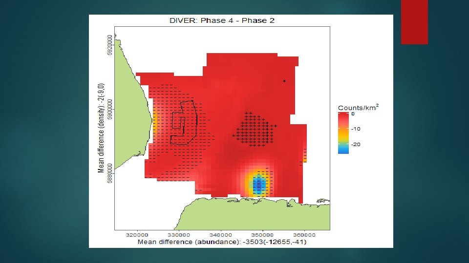
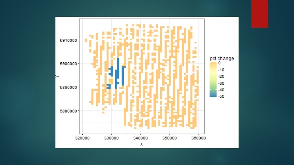
Quantifying the effects of any changes going forward Quantifying changes in: Distribution Abundance Home range Overlap with other creatures (including humans)
Quantifying the effects of any changes going forward Assessing Site the power to detect change: wide changes (e. g. overall decline) Localised changes/redistribution (e. g. lower numbers at a disturbance site Use what we have as ‘reality’ Impose change scenarios What’s the chance we detect change when it’s there?
Some ideas about how to achieve these outcomes: Collaboration Strategic planning via a group representing all stakeholders: Policy makers, industry, scientists, community representatives What do we know? Where are the gaps? Prioritise Sharing filling these gaps & identifying funders data: commonly agreed format
Some ideas about how to achieve these outcomes: Understanding the current situation Data on the right spatial and temporal scales Collecting covariate information (or getting it somehow) Using methods which are fit-for-purpose Telemetry data is repeated measures data (many observations on relatively few individuals) and the analysis methods must account for the correlated nature of the data.
Some ideas about how to achieve these outcomes: Understanding the current situation Using methods which are fit-for-purpose: Pretending your data are sets of independent points can lead you to make dodgy conclusions. You are likely to conclude that covariate relationships/effects are genuine when they are not. You are likely to conclude that change has occurred when it has not. Boundaries should be respected and explicitly included in the analysis approach to avoid `leakage’ across boundaries. This would also enable fence effects to be quantified.
Some ideas about how to achieve these outcomes: Quantifying changes using trusted/standardised methods: Distribution, Abundance, Home range etc Translating results to stakeholders Linking shifts in distributional patterns with behaviour to make meaningful conclusions: What were they doing when they were there? What are they doing now? What are the population consequences of this change?
Some ideas about how to achieve these outcomes: Quantifying change Given the data/model available, what is the power to detect change? Site wide changes in abundance(e. g. overall decline) Localised changes/redistribution. Shifts in species distribution and abundance.
Possible next actions Form/co-opt a well composed group and make a plan Think critically about any model-based results: Does your analysis pass the ‘sniff test’? Help the decision makers by listing the important things to check Training and/or collaboration Can the results form case studies for use in universities/schools? Masters student projects, Ph. D projects, post-doctoral researchers
Possible next actions Quantify the power to detect change based on what we know - do we have sufficient data? Convert the satellite tracking data into conservation activities