An Introduction to GPS Outline Why GPS n


 § This")
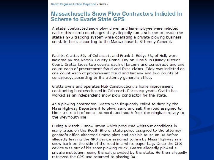
 For national security reasons, the military sometimes degrades the C-code signal.")


 is a differential GPS system that")


 These are")


")


… “add on” service n Create a")


 n DNR")


- Slides: 86
An Introduction to GPS
Outline Why GPS? n What is GPS? n How GPS Works. n What you need to know about GPS. n What can you do with GPS? n Applications of GPS. n
Why GPS? n Many features have addresses and landmarks that are associated with a destination. Kevin Jones 2453 Main Street Blacksburg, VA 24060
Why GPS? n n Many features have addresses and landmarks to get you to a destination. However, there are many features that do not have addresses…
Why GPS? n n n Many features have addresses and landmarks to get you to a destination However, there are many features that do not have addresses… There are many MAJOR cities that do not even have STREET NAMES!
Why GPS? n n Many features have addresses and landmarks to get you to a destination However, there are many features that do not have addresses… There are many cities that do not even have STREET NAMES! And then there is the open ocean and sky…
Why GPS? Location, Location and INFORMATION!!!
Pre-GPS Navigation is critical!!! n Historical Navigational tools have limits: -The Sextant – contingent on weather n
Pre-GPS Navigation is critical n Historical Navigational tools have limits: -The Sextant – contingent on weather -Radionavigation (Lowrance): only works near land… n
Pre-GPS Navigation is critical n Historical Navigational tools have limits: -The Sextant – doesn’t work if it is cloudy -Lowrance – radionavigation: only worked near land… n The military had its own reasons for determining location… -Identify targets -Friendly fire issues -“smart bombs” n
What is GPS… And how does it work?
What is GPS? n n GPS is not a single UNIT! GPS = Global Positioning SYSTEM GPS was developed by the Department of Defense at a cost of >$12 billion Funding for the GPS was contingent on making the system available to the public.
GPS is a SYSTEM There are three major components in this system: 1. Satellites 2. Ground Control Stations 3. GPS Receivers (or units)
Satellites n n n There are 24 -32 satellites up there at any given time orbiting the earth at ~11, 000 naut. miles. The DOD knows the EXACT location of each of the satellites at any given moment. These satellites have VERY accurate clocks on board. The satellites continuously send radio signals towards earth. These radio signals are picked up by GPS receivers.
Control Stations n There are five control stations that monitor the satellites. • Control stations enable information on Earth to be transmitted to the satellites (updates and fine turning). • Control stations continuously track satellites, and update the positions of each satellite. • Without control stations, the accuracy of the system would degrade in a matter of days.
GPS Receivers • GPS units are referred to as “receivers”. • They receive information (radio signals) from satellites. • The GPS receiver knows how long it takes the signal to travel from the satellite to the receiver.
GPS Receivers • The GPS receiver knows how long it takes the signal to travel from the satellite to the receiver. • The Receiver is therefore able to calculate its distance from the satellite. -Distance = time x velocity -Distance = time x 186, 355 mi. /sec. • The receiver can calculate the time that signal traveled from the satellite to the receiver. • The receiver is therefore able to determine its exact distance from the satellite.
How GPS Works One satellite…
How GPS Works If the GPS receiver only obtains signals from 1 Satellite, then it “knows” that it is located somewhere on this sphere…
How GPS Works
How GPS Works If the GPS receiver only obtains signals from 2 satellites, then it “knows” that it is located somewhere these 2 spheres intersect
How GPS Works
How GPS Works If the GPS obtains signals from 3 satellites, then it “knows” that it is located somewhere these 3 spheres intersect (2 points)
How GPS Works
How GPS Works A fourth satellite is required to determine the exact location and elevation.
What do you need to know about GPS…
Different “Grades” of GPS receivers n Recreational Grade GPS -Accurate to within 5 meters (could be better, but don’t rely on it) -Suitable for hunting, recreational, and some business uses -Lowest cost (smallest, and easiest to use): ~$100 -$800 n Mapping Grade GPS -Accurate to within 1 meter (3 feet) -Requires differential processing (from a base station) -Suitable for many natural resource applications, city planning -$3, 000 -7, 000 n Survey Grade GPS -Accurate to within 1 cm -Suitable for building bridges… -~$20, 000
What you need to know about GPS n n n Signal Accuracy Issues Selective Availability Tricks of the Trade Current Applications of GPS Future applications of GPS
Signal Accuracy There are 2 types of GPS Signals: P-code: (“Precise” code) § This is only available to the military and some selected public officials. § Very precise, not degraded. C-code: (“Civilian” Code). § Less precise § Signal can be degraded (by scrambling the signal) especially in times of conflict. § This is what the GARMIN Legends (and all public GPS receivers) work with…
Selective Availability (SA) For national security reasons, the military sometimes degrades the C-code signal. This is called selective availability. n These errors are random n Errors can be as high as +300 feet n Never say never…. But SA Will probably not be “turned on” again….
Selective Availability SA errors can put you on the wrong side of a stream, or even a different city block or street! n 300 feet is a lot of real estate!!! n The GPS tells you that you are located here… But your real location is here…
Selective Availability It is possible to correct for Selective Availability (as well as other inherent signal errors). n This process is called Differential Correction n Here’s how it works… n
Differential Correction n n There already established base stations established around the U. S. Surveyors have determined the precise location of these base stations. Each base station has a GPS receiver, which collects incoming (scrambled) signals. The true (surveyed) location is then compared to the GPS coordinates. The correction values are then sent to other GPS receivers in the field.
Differential Correction Base station w/ GPS receiver at known location: Differential Correction Signal GPS receiver in the field collecting points, routes, etc. Exact known coordinates differ significantly from GPS coordinates at this location = exact amount of error!
WAAS • The Wide Area Augmentation System (WAAS) is a differential GPS system that is being constructed to support GPS accuracy in aircraft. • WAAS also provides additional accuracy “on the ground” • The GPS receivers that we are using are WAAS compatible
WAAS Note: Not all GPS receivers are WAAS compatible. 90% of GPS receivers on the market today are WAAS compatible The GARMIN Legend is WAAS compatible
Other Tricks of the Trade: Averaging: A GPS receiver can collect points continuously for 15 -30 seconds. The receiver can then average all these locations together n This only works when you are standing still!! n GPS Collected Points GPS Averaged Position “True” location
Other Tricks of the Trade: Satellite Distribution n It is better for your receiver to get a fix on “distributed” satellites, then poorly distributed satellites. “Positional Dilution of Precision” Good Satellite Distribution Poor Satellite Distribution
Other Tricks of the Trade: Multi. Path Errors Try and stay away from buildings and other structures when using a GPS receiver Satellites may not be visible… This can introduce error…
Other Tricks of the Trade: Tracking Satellites GPS has worldwide coverage… HOWEVER… You can lose satellite coverage (or received degraded signals) in areas with dense foliage, in “urban canyons”, etc. You may also lose satellite coverage (or receive degraded signals) in deep valleys or gorges.
How accurate is a $130 GPS? n That’s the million dollar question…
It depends… Acknowledgements: Dr. Phillip Rasmussen, Utah Geospatial Extension Specialist
Brand “A” Day 1 Brand “A” Day 2 Brand “A” Day 3 Brand “A” Day 4 Brand “A” Day 5 Brand “B” Day 1 Brand “B” Day 2 Brand “B” Day 3 Brand “B” Day 4 Brand “B” Day 5
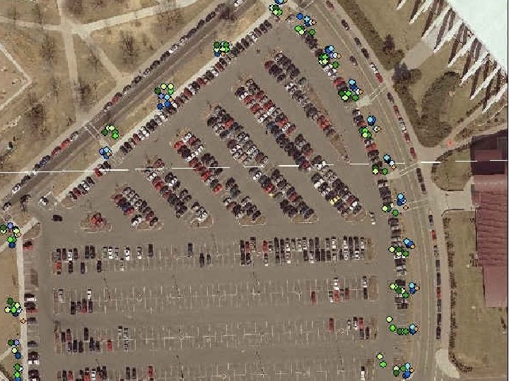
What can you do with a GPS? Collect and store points (positions) These are called Way. Points. Field corners, insect infestation areas, crop damage, individual trees, trail heads, creek crossings, point source pollution, etc. n Download the points onto your computer and integrate them with other mapping programs n
Waypoints Corner-2 Point 3 Latitude: 37° 16’ 18” Longitude: W 80° 28’ 45” Elevation: 2108 feet 001
What can you do with a GPS? Collect and store the path that you have walked / driven n These paths are called TRACKS. n Calculate the distance of a track (i. e. perimeter around a field) n Calculate AREA measurements within a TRACK (after walking around a field) n Save and Download TRACKS onto your computer. n
Tracks (just start walking…)
What can you do with a GPS? Collect and store ROUTES n Routes are similar to TRACKS, but are created by Waypoints n Routes can be handy for measuring “square fields” and “straight lines” n You can measure the length and area (acreage) of a Route. n
Routes #3 #2 #4 #1 #5 1. Establish Waypoints at strategic locations 2. The GPS Receiver “Connects the dots” 3. Area and perimeter measurements are generated
What can you do with a GPS? n n The GOTO function Using the ‘GOTO’ function, the GPS will guide you to a predefined Waypoint (you choose which one…) using a compass and “pointer” The GOTO/FIND function is like using “Autopilot” You can program the GPS to “beep” when you are within a certain distance of a selected Waypoint
What can you do with a GPS? Tide Tables n Many of the marine GPS’s have built in tide tables. They provide tidal information and ranges for any date and any place… n The GARMIN Legend does not have tide table information… n
What can you do with a GPS? Speed GPS’s calculate your ground speed as you walk, run, drive, or fly n
What can you do with a GPS? n Elevation In addition to providing you with your latitude and longitude, GPS provides you with elevation information. Elevation is not as accurate as X, Y information. Some GPS’s have built in barometric altimeters (to increase accuracy of z values).
What can you do with a GPS? n Measure Area / perimeter Farmers can use a GPS to measure the area of a pasture or a field of corn… Natural Resource Agents can measure the area of a proposed conservation easement…
Current Application Areas of GPS n n n n Public Safety Environmental resource management Aviation Military Local planning Surveying Recreation Business
The Future of GPS Acknowledgements: Keith Clarke
The Future is bright… n The Do. D is in the process of upgrading the existing GPS satellite constellation -better coverage availability (i. e. in forested areas) -anticipated greater accuracy (even for the recreational grade GPS receivers)
WAAS Satellites Historically, some areas in Virginia have had trouble acquiring the WAAS satellite n A new WAAS satellite was launched in Fall 2006 n Better coverage for Virginia and higher accuracy levels n
The Russian GPS System Is called GLONASS n Has fallen into “disrepair”. n New Russian GLONASS satellites are now being launched n Impacts: Potentially increased accuracy for US receivers that receive both US and Russian GPS satellite signals (the private sector follows demand…) n
The European GPS System n n Galileo will be Europe’s own global navigation satellite system More accurate than the U. S. ’s current GPS system (~4 feet) Better coverage area than the U. S. ’s current GPS system Compatible and interoperable with the American global positioning system Europeans, Chinese, India, etc.
GPS Receivers n Continue to get better and better -better antennae, -more efficient power consumption, -smaller -increasingly more “bells + whistles” (maps, hard drives, etc. ) -inexpensive
Purchasing a GPS? Check out the specs. !
The applications are endless… …and keep in mind that there are ~253, 476, 000 cell phone subscribers in the U. S. -Source: http: //www. ctia. org
GPS recreational uses Geocaching…. Geocaching is an entertaining adventure game for gps users. n The idea is to “hunt” for objects (prizes) that have been placed in the landscape (virtual orienteering). n Pick a prize, and leave a prize… n http: //www. geocaching. com
but Geocaching is so passé… n But have you ever tried Geodashing? n In this game, a list of coordinates is presented to all users and teams, selected at random from around the globe. Requirements: • somebody with a lot of free time on their hands, • a GPS, • extra batteries, • a new pair of sneakers, • a passport, • and your dad’s VISA Card (or a trust fund)….
Some GPS Applications are “innovative” Use GPS to locate ‘the loo’! http: //www. cnn. com/2007/WORLD/europe/1 1/29/sat. lav. ap/index. html n
GPS-based buddy stalkers (oops, I mean buddy tracking)… “add on” service n Create a buddy list and locate your pals on your cell phone. n Is your girlfriend really at the library…? n
Here’s an International ‘cell phone locator’ n http: //www. satellite-gps-locator. com/
Other GPS Data Loggers and Tracking Devices… We all know that UPS / Fed. Ex and the major freight haulers use GPS… n Other folks are tracking people too! n
Car Navigation Systems are getting into buddy tracking as well n Garmin and Tom have well established systems in place…
Car Insurance companies have been looking at this technology for a while…
GPS-based tracking, routing, and fleet management
GPS Fights Crime!
Recreational Opportunities – Virtual Soccer n http: //navball. wordpress. com
The Degree Confluence Project http: //confluence. org/ The "world's largest distributed expedition project“. n Goal: to visit each of the latitude and longitude integer degree intersections in the world, and to take pictures at each location. n
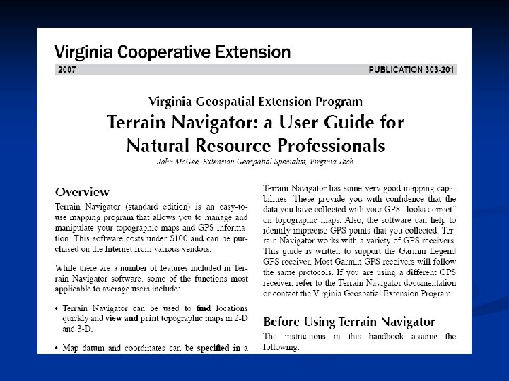
There’s a Variety of Software Products Available to Support GPS Utility (free) n DNR Garmin (free) n USA Photo. Maps (free) n Photo 2 GPS (free) n Terrain Navigator (~$89) n
Additional Resources for your Use
Things to remember… n n n GPS can serve as an accurate data collection tool for GIS applications; GPS applications are becoming increasingly prevalent in our society, and support a variety of applications; With GPS receivers, you (more or less) get what you pay for (w/ prices ranging from $59 $20, 000+) This technology is going to take over our lives! Knowing how to use a GPS does not make you a surveyor!!!
Any Questions? Virginia Geospatial Extension Program http: //www. cnr. vt. edu/gep John Mc. Gee Ph. D. Geospatial Extension Specialist jmcg@vt. edu (540) 231 -2428 Jennifer Mc. Kee Geospatial Project Developer jmckee@vt. edu (540) 231 -9115