American Samoa Benthic Terrain Viewer Larkin 2001 Emily
 Emily M. Larkin and Dawn Wright Dept.")
American Samoa Benthic Terrain Viewer (Larkin 2001) Emily M. Larkin and Dawn Wright Dept. of Geosciences, Oregon State University September, 2004

The American Samoa Benthic Terrain Viewer • Web-based GIS to allow more access to marine • data from American Samoa What is a Web-Based GIS? – A website that allows users to view geographic data without GIS software. • The ONLY Samoan-language web-based GIS in existence.

Why use a Web GIS? • Natural medium for data distribution and • • display. User needs only a web browser to access data. Allows multiple levels of users to be served by the same site. – General users can access information, perform queries, analyses, and make maps. – Advanced users can download data and metadata through the FBNMS GIS Data Archive and search for more detailed information.
 layers obtained from • • multibeam sonar surveys in")
ASBTV Content • Bathymetry (seafloor) layers obtained from • • multibeam sonar surveys in 2001 and 2002 (Wright et al. 2002; Wright 2002). Benthic zone and structure layers derived from bathymetry. Terrestrial layers—roads, island DEMs, villages. Supporting help and information pages with links to find more information. Link to American Samoa Coastal and Marine Bibliographic Database

Benthic Zones & Structures • The seafloor can be classified into broad categories called benthic zones and more detailed categories called benthic structures – Benthic = related to the seafloor (e. g. a benthic animal is one that lives on the ocean floor) – 4 categories of zones: flats, slopes, crests, and depressions – 13 categories of structures
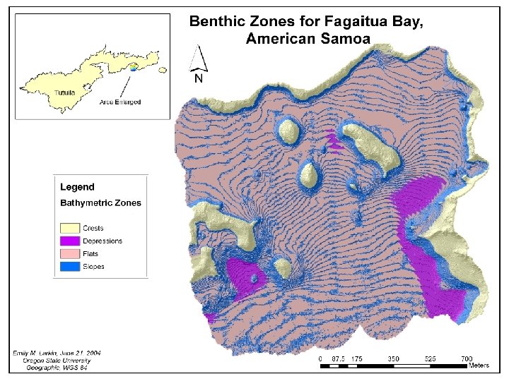
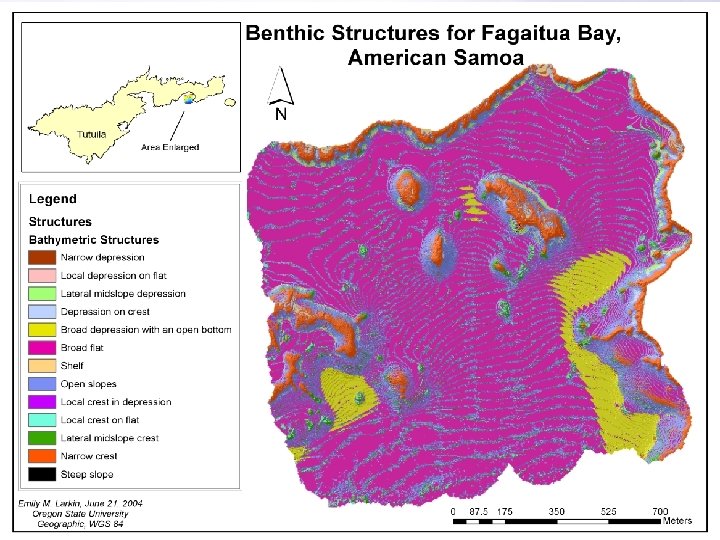

Fagaitua Bay Benthic Zones from Arc. Map Benthic Zones from the ASBTV

Zones/Structures and Biodiversity • Benthic zones and structures cannot be tied to specific habitat types or species at this time. • Karlson et al. (2004) found a link between benthic zone and biodiversity in Indo-Pacific coral reefs. – In general, sloped areas had higher biodiversity than flat areas. – Their samples included American Samoa

Initial Display of the ASBTV Overview Map Active tool display Link to Samoan version of site Zoom to study area Links to help, data download and info pages

Samoan-Language Access • Greater accessibility for those who may be • • • more comfortable in Samoan than in English Same content as ASBTV O le ‘Alititai o Amerika Samoa = The Seafloor of American Samoa Challenges— – Not all scientific terms translate well into Samoan (e. g. benthic structure) – Arc. IMS does not like diacritical marks—e. g. Su’e (search) appears in the Mode frame as Sue (a type of pufferfish)

O le ‘Alititai o Amerika Samoa

What Still Needs Done? • Error-checking the Samoan grammar • Addition of final benthic zones for Vatia Bay

American Samoa Coastal & Marine Bibliographic Database • A searchable bibliographic database listing references related to American Samoa • Goes back to mid-1800 s • Searchable by keyword, author or area

ASBTV Site Links • English http: //scallywag. science. oregonstate. edu/website/Am. Samoa/viewer. htm • Samoan http: //scallywag. science. oregonstate. edu/website/Faasamoa/viewer. htm • American Samoa Coastal & Marine Bibliographic Database –http: //astrolabe. csc. noaa. gov/American_Samoa/search. asp • More information or questions: larkine@science. oregonstate. edu
- Slides: 15