ALMUSTANSIRIYAH UNIVERSITY COLLEGE OF SCIENCES ATMOSPHERIC SCIENCES DEPARTMENT


 The term Quantitative Precipitation Estimation, or QPE, refers to the estimation")


 Ø A ORG measures the scintillation in an optical beam")


- Slides: 22
AL-MUSTANSIRIYAH UNIVERSITY COLLEGE OF SCIENCES ATMOSPHERIC SCIENCES DEPARTMENT /SECOND CLASS The Course of Meteorological Instrumentation and Observations Dr. Sama Khalid Mohammed
WELCOME STUDENTS! LECTURE SIX – PART 2
Precipitation refers to any product of the condensation of atmospheric water vapor that is deposited on the Earth's surface. Precipitation intensity can be measured by precipitation rate (R), which is normally defined as the rain water falling on ground per unit area per unit time, of unit in SI system which is the same concept of mass flux. So, basically precipitation rate is measured by depth per unit time. m/s is too large for precipitation measurement. In real practice, we usually use unit of mm/h.
Forms of precipitation
Precipitation Estimation (QPE) The term Quantitative Precipitation Estimation, or QPE, refers to the estimation of observed precipitation. Observed precipitation is only an estimate because the tools used provide inexact approximations of the actual magnitude and distribution of precipitation. RAIN GAUGE Precipitation can be measured at a fixed location (point estimates) by a rain gauge, and will not necessarily provide good spatial resolution. It measures rain as well as the liquid equivalent of frozen precipitation that has fallen over a specific time period. Rain gauges come in a variety of styles, both manual and automated.
It consists of a large cylinder with a funnel and a smaller measuring tube inside of it. The official rain gauge has a 50 centimeter high cylinder with a 20 centimeter in diameter funnel that collects water into a measuring tube that has exactly one-tenth the cross sectional area of the top of the funnel. The reason for the smaller measuring tube is that more precise rainfall measurements can be made due to the exaggeration of the height of water in the tube. For example, one-tenth of an inch of rainfall would actually fill an inch of the measuring tube.
Ø The standard rain gauge can measure up to two inches of rain. Ø If rainfall exceeds two inches, water overflows into the cylinder surrounding the measuring tube. The observer takes the water in the cylinder and very carefully pours it into the measuring tube after emptying the tube. The observer then adds the measurement from the water in the cylinder to two inches in order to obtain the final rainfall amount. The rain gauge can be heated to measure the water equivalent of snow. Ø Rain gauges can provide excellent information if they are wellmaintained, optimally located, and the wind is light. Ø In situations where good radar coverage exists, it is possible that high wind situations may cause greater uncertainties in the accuracy of the gauges than that of the radar (for exposed gauges, and for snowflakes and small liquid drops). A user of multiple precipitation sensors may want to consider the possibility that under such conditions it may not be wise to adjust the radar with the rain gauge data.
Tipping bucket rain gauge Ø Two specially designed buckets tip when the weight of. 01 inches of rain falls into them. When one bucket tips, the other bucket quickly moves into place to catch the rain. Ø Each time a bucket tips, an electronic signal is sent to a recorder. To calculate the rainfall for a certain time period, simply multiply the number of marks on the recorder by. 01 inches.
Ø The tipping bucket rain gauge is especially good at measuring drizzle and very light rainfall events. Counts the tips; and it can be automated. If the recorder is equipped with a clock, you can determine how much rain fell during certain time periods without actually being present at the station. Ø Disadvantages: oscillations of buckets in high winds; evaporation, overflow with heavy rain. Thus, one weakness of the tipping bucket rain gauge is that it often underestimates rainfall during very heavy rain events, such as thunderstorms.
Optical rain gauge (ORG) Ø A ORG measures the scintillation in an optical beam produced by raindrops falling between a light source and an optical receiver. Ø It provides accurate measurement of rain rate, which makes the instrument more reliable than traditional tipping buckets or collection gauges which have problems with very light and heavy events. Ø The ORG is not affected by overcapacity and not greatly influenced by wind effects as are mechanical methods. Ø Falling rain droplets cause intensity variations in the light (or infrared). By measuring the energy in selected frequency bands of the scintillation spectrum and comparing their ratios, the occurrence of precipitation, type of precipitation, and intensity of precipitation can be estimated as illustrated by the figure below.
Disdrometer: used to measure the drop size distribution and velocity of falling hydrometeors. Rain intensity may be determined by measuring the falling speeds of rain droplets Falling speed of rain droplet The mass flux of rain fall can be computed as, where V(Di) is the fall velocity of droplets, which depends on the size of the drop.
Vertical momentum of an impacting raindrop can be transformed into an electric pulse whose amplitude is a function of drop diameter The pulse height analysis will yield the size distribution of raindrops.
Another type of disdrometers uses a video camera to directly count drops to give distribution of rain droplets N (D) or number density of the drops, so that rain droplets can be sized. This disdrometer uses two, side video to record optical images of each raindrop.
The disdrometers may also be designed based on acoustic signals. The sound of individual raindrops hitting the surface is different due to the intense compression wave generated by the impact. The energy of this wave is proportional to the rain drop kinetic energy. Hydrophones may be used to measure the characteristics of individual drops and to distinguish cases where more than one drop arrives almost simultaneously. Since the acoustic frequencies of individual raindrops hitting the surface is different, Disdrometers may be designed by analyzing the frequencies, so that the rain droplet distribution can be determined.
Remote Sensing of QPE Precipitation accumulation is routinely derived from radar and satellite observations. Despite the inconsistencies in radar-derived precipitation from location to location and from season to season, radar guidance is considered superior to satellite guidance of QPE in many areas. This is mainly due to the superior resolution in both space and time and often better quantitative guidance. Precipitation radar Weather radars are both transmitters and receivers, transmit a microwave beam and then "listen" for echoes that bounce back from precipitationsized particles (or "targets") within or falling from clouds. Since we know both the direction in which the radar transmitter is pointing and the speed at which microwaves travel (close to the speed of light), the direction and distance from the transmitter to the precipitation can be determined. This permits mapping of precipitation over the region surrounding the radar site.
Precipitation intensity can be determined by measuring the strength of the echoes received by the radar antenna. The amount of energy reflected back to the radar is proportional to the precipitation intensity ”the greater the energy reflected back to the radar, the greater the precipitation intensity”. Radar reflectivity (Z), expressed in units of d. BZ, is used to compute rainfall rates (R) in mm/h using a reflectivity to rainfall rate relationship. This is known as the Z-R relationship. Rainfall rates then get integrated over time to produce accumulation for various time periods. Z = reflectivity factor D = drop diameter N(D) = number of drops of given diameter per cubic meter This gives us a Z-R relationship; and it is presented to explain the sensitivity of reflectivity factor, Z, to drop diameter. Because the drop diameter is raised to the 6 th power, small changes in drop diameter result in very large changes to Z. And large changes to Z result in large changes to derived rainfall rates.
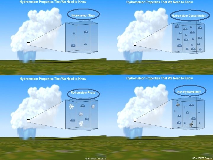
Z-R varies with type of rain. There were 69 Z-R relationships, and the average Z-R relationship of all of them is The relationship between reflectivity and rainfall rate, and thus the Z-R relationship, varies with time, location, and season. Hydrometeor properties that influence the Z-R relationship include size, concentration, and phase. Accuracy of derived rainfall rates is further impacted by the presence of non-hydrometeors, and whether the radar is sampling a region that is representative of precipitation reaching the ground.
Doppler precipitation radar Doppler radar is radar that makes use of the Doppler Effect, is the change in frequency of a wave for an observer moving relative to the source of the waves. The same effect takes place in the atmosphere as a pulse of energy (a microwave signal) from a radar strikes an object and is reflected back toward the radar. The radar measures the phase change of the reflected pulse of energy, which is then converted to the velocity of the object, either toward or from the radar.
Measuring precipitation from space Rainfall can be inferred from the temperature of cloud tops. Microwave radiation emitted by clouds can be used to discern rainfall intensity. For TRMM, a weather radar can transmit a beam of microwave energy downward inside clouds; the energy scattered back to the radar by raindrops provides information on rain intensity and its vertical distribution Tropical Rainfall Measuring Mission (TRMM) was launched by the National Aeronautics and Space Administration (NASA) and the National Space Development Agency of Japan (NASDA). TRMM was the first satellite dedicated to rainfall measurement, and is the only satellite that carries a weather radar until recently launched Cloud. Sat/CALIPSO (the Cloud. Aerosol Lidar and Infrared Pathfinder Satellite Observation).
TRMM has a limited view of the Earth, ranging from 36 N to 36 S, and samples rain relatively infrequently, passing over the same location about once a day. TRMM is insensitive to light rainfall. Also, cloud top temperatures are imperfectly correlated with actual rainfall reaching the surface.
Satellite QPE Satellite estimation of precipitation is potentially useful in areas with poor coverage from radars and rain gauges. Although satellite sampling is more consistent from place to place than radar sampling, satellitederived precipitation is lower resolution and generally less accurate than radar-derived precipitation. It is therefore considered a supplement, not a replacement for the radar products.