Airborne Doppler radar observations of midlatitude storms during

Airborne Doppler radar observations of mid-latitude storms during OLYMPEX Jennifer De. Hart and Robert Houze Pacific Northwest Weather Workshop 3. 3. 17 NASA grants: NNX 15 AN 52 H, NNX 13 AG 71 G, NNX 15 AL 38 G, NNX 16 AD 75 G NSF grant: AGS-1503155

APR-3 • NASA DC-8 equipped with the Advanced Precipitation Radar 3 – Ku / Ka / W band – High vertical resolution • Goal: document structure around the Olympics and compare with

8 Dec. 2015 NARR integrated vapor transport and precipitation c/o Joe Zagrodnik

• Data collection in remote regions • inland, valleys, high terrain, lee • Greatest enhancement near windward slopes • not highest terrain • Echo tops descend in lee Windward

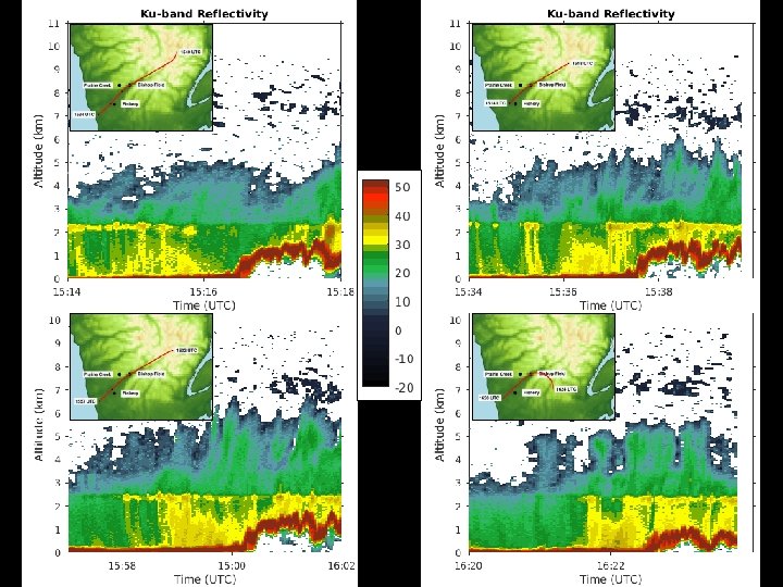
Zoom in on Quinault Valley 8 Dec

• Enhancement occurs not only at low levels, but extends up through the bright band • Secondary maximum between 4 and 6 km Windward

13 Nov. 2015 NARR integrated vapor transport and precipitation c/o Joe Zagrodnik

12 Nov

Different vertical structures 11/1 3 12/0 8 • Low-level enhancement location similar – more intense on 12/08 – lies below bright band on 11/13

Surface rainfall • Rainfall similar on both days, despite radar reflectivity differences

• Reflectivity dominated by large diameter hydrometeors • Estimate reflectivity/rainfall from surface observations
 Fraction of large drops (2 -4 mm)")
Fraction of medium drops (1 -2 mm) Fraction of large drops (2 -4 mm)

Conclusions • APR-3 provides view around the Olympic peninsula, especially over high terrain • Strong spatial and temporal variability, but enhancement preferentially along windward slopes • Radar cross-sections suggest that regimes dominated by small to medium drop growth may be underestimated by reflectivity
- Slides: 14