Air Masses Fronts This chapter discusses 1 Classification
- Slides: 37

Air Masses & Fronts This chapter discusses: 1. Classification of 4 North American air masses based on cold or warm land mass and ocean origin 2. Air mass delineation and movement along stationary, cold, warm, and occluded fronts

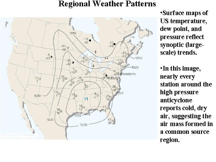
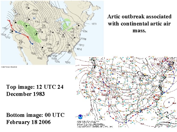
Regional Weather Patterns • Surface maps of US temperature, dew point, and pressure reflect synoptic (largescale) trends. • In this image, nearly every station around the high pressure anticyclone reports cold, dry air, suggesting the air mass formed in a common source region.

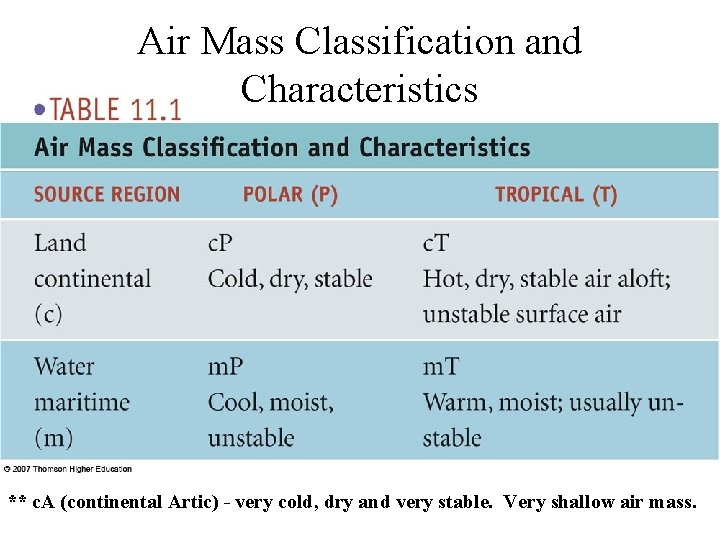
Air Mass Classification and Characteristics ** c. A (continental Artic) - very cold, dry and very stable. Very shallow air mass.

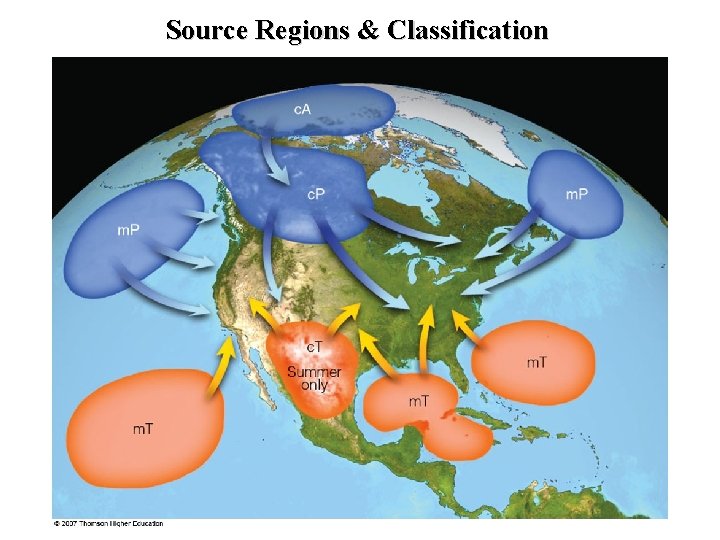
Source Regions & Classification

• Air masses of similar temperature and humidity form above flat, uniform regions with light surface winds. • Air masses are associated with surface high pressure. • Typical U. S. air masses: maritime Polar (m. P) - moist and cold continental Polar (c. P) - dry and cold maritime Tropical (m. T) - moist and warm continental Tropical (c. T) (warm season only) - dry and hot continental Artic (c. A) (cold season only) - very dry and very cold

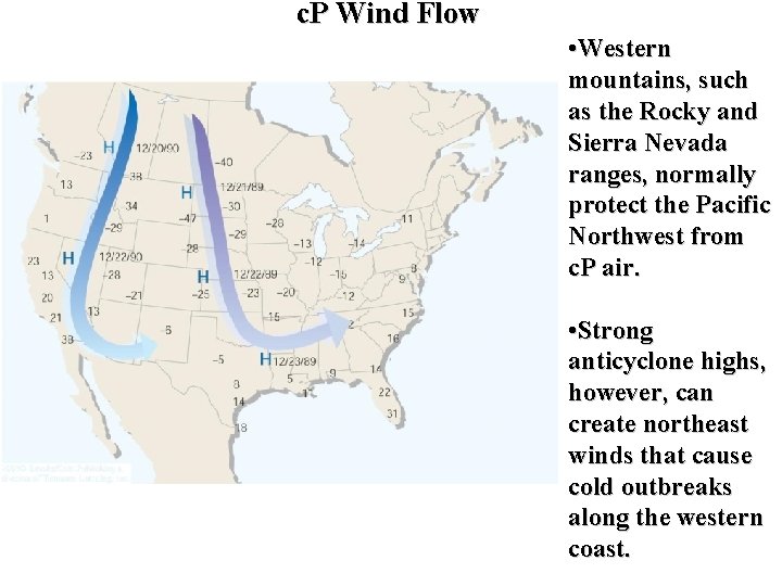
c. P Wind Flow • Western mountains, such as the Rocky and Sierra Nevada ranges, normally protect the Pacific Northwest from c. P air. • Strong anticyclone highs, however, can create northeast winds that cause cold outbreaks along the western coast.

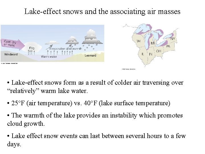
Lake-effect snows and the associating air masses • Lake-effect snows form as a result of colder air traversing over “relatively” warm lake water. • 25 F (air temperature) vs. 40 F (lake surface temperature) • The warmth of the lake provides an instability which promotes cloud growth. • Lake effect snow events can last between several hours to a few days.

Artic outbreak associated with continental artic air mass. Top image: 12 UTC 24 December 1983 Bottom image: 00 UTC February 18 2006

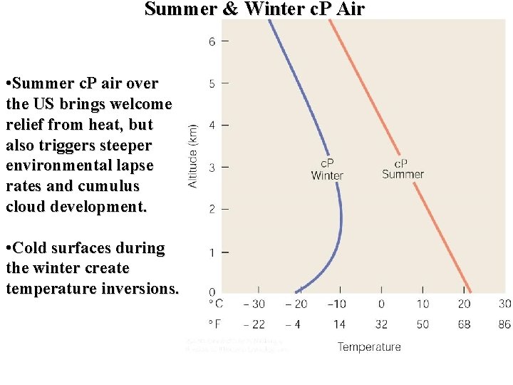
Summer & Winter c. P Air • Summer c. P air over the US brings welcome relief from heat, but also triggers steeper environmental lapse rates and cumulus cloud development. • Cold surfaces during the winter create temperature inversions.

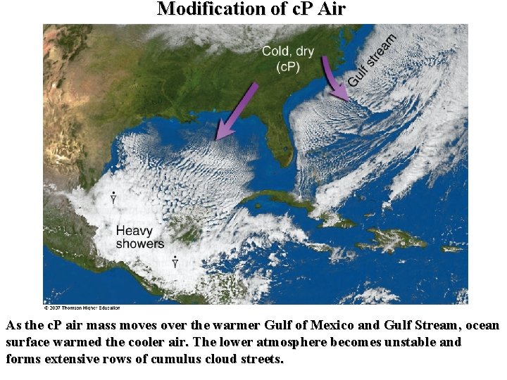
Modification of c. P Air As the c. P air mass moves over the warmer Gulf of Mexico and Gulf Stream, ocean surface warmed the cooler air. The lower atmosphere becomes unstable and forms extensive rows of cumulus cloud streets.

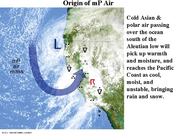
Origin of m. P Air Cold Asian & polar air passing over the ocean south of the Aleutian low will pick up warmth and moisture, and reaches the Pacific Coast as cool, moist, and unstable, bringing rain and snow.

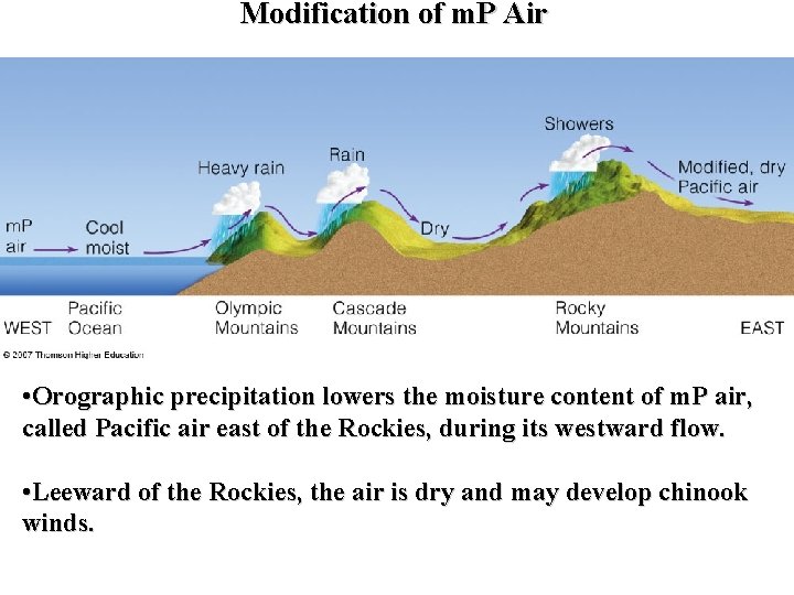
Modification of m. P Air • Orographic precipitation lowers the moisture content of m. P air, called Pacific air east of the Rockies, during its westward flow. • Leeward of the Rockies, the air is dry and may develop chinook winds.

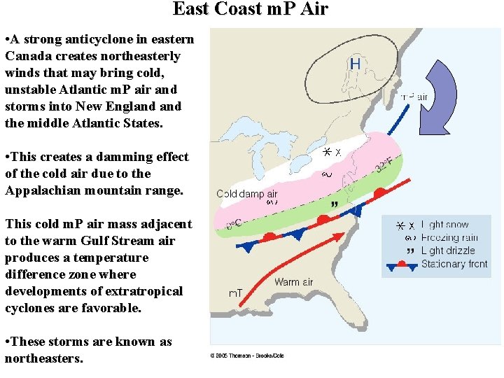
East Coast m. P Air • A strong anticyclone in eastern Canada creates northeasterly winds that may bring cold, unstable Atlantic m. P air and storms into New England the middle Atlantic States. • This creates a damming effect of the cold air due to the Appalachian mountain range. This cold m. P air mass adjacent to the warm Gulf Stream air produces a temperature difference zone where developments of extratropical cyclones are favorable. • These storms are known as northeasters.

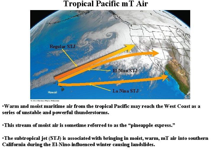
Tropical Pacific m. T Air Regular STJ El Nino STJ La Nina STJ • Warm and moist maritime air from the tropical Pacific may reach the West Coast as a series of unstable and powerful thunderstorms. • This stream of moist air is sometime referred to as the “pineapple express. ” • The subtropical jet (STJ) is associated with bringing in moist, warm, m. T air into southern California during the El-Nino-influenced winter causing landslides.

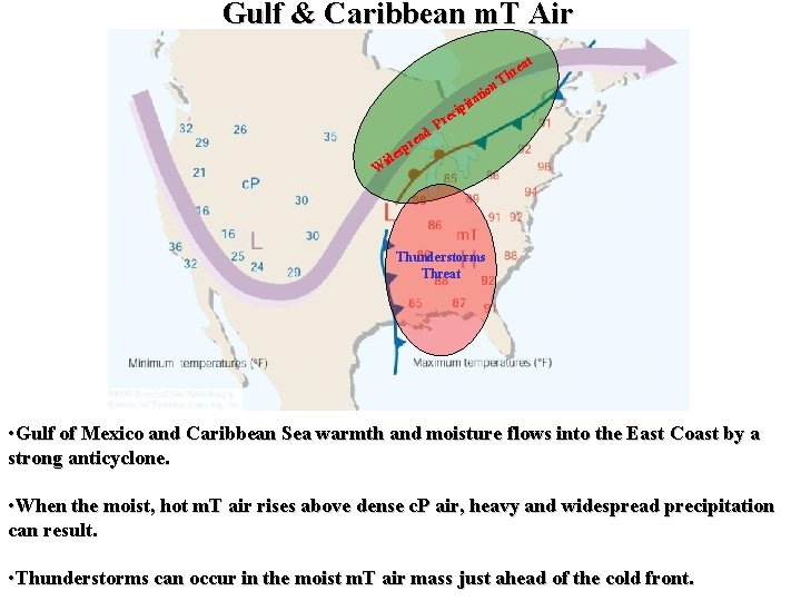
Gulf & Caribbean m. T Air ci W at e pr s ide ad e Pr n tio a t pi re Th Thunderstorms Threat • Gulf of Mexico and Caribbean Sea warmth and moisture flows into the East Coast by a strong anticyclone. • When the moist, hot m. T air rises above dense c. P air, heavy and widespread precipitation can result. • Thunderstorms can occur in the moist m. T air mass just ahead of the cold front.

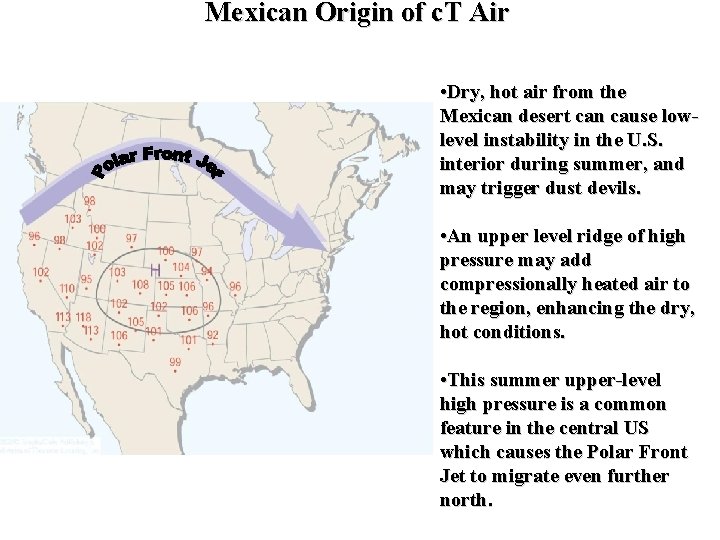
Mexican Origin of c. T Air • Dry, hot air from the Mexican desert can cause lowlevel instability in the U. S. interior during summer, and may trigger dust devils. • An upper level ridge of high pressure may add compressionally heated air to the region, enhancing the dry, hot conditions. • This summer upper-level high pressure is a common feature in the central US which causes the Polar Front Jet to migrate even further north.

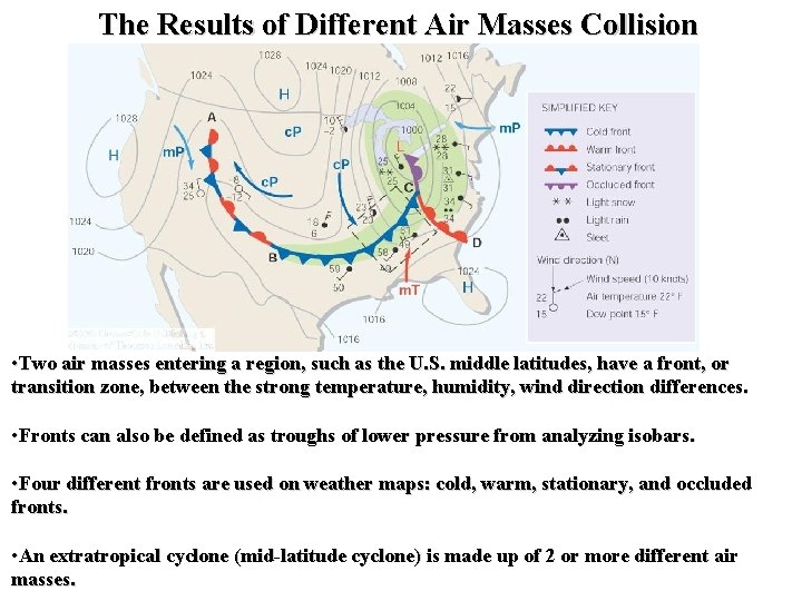
The Results of Different Air Masses Collision • Two air masses entering a region, such as the U. S. middle latitudes, have a front, or transition zone, between the strong temperature, humidity, wind direction differences. • Fronts can also be defined as troughs of lower pressure from analyzing isobars. • Four different fronts are used on weather maps: cold, warm, stationary, and occluded fronts. • An extratropical cyclone (mid-latitude cyclone) is made up of 2 or more different air masses.

Fronts “the transition zone between two distinct air masses” • Cold – a transition zone where a cold air mass advances and replaces a warm air mass. • Warm – a front that moves in such a way that warm air replaces cold air. • Occluded (occlusion-“closed off”) – a complex frontal system that ideally forms when a cold front overtakes a warm front. – When the air behind the front is colder than the air ahead of it, the front is called a cold occlusion. Cold Cool – When the air behind the front is milder than the air ahead of it, the front is called a warm occlusion. Cool Cold • Stationary – a front that is nearly stationary with winds blowing parallel and from the opposite directions on each side of the front at the surface.

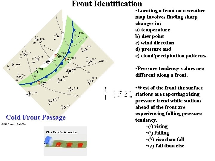
Front Identification • Locating a front on a weather map involves finding sharp changes in: a) temperature b) dew point c) wind direction d) pressure and e) cloud/precipitation patterns. • Pressure tendency values are different along a front. Cold Front Passage Click Here for Animation • West of the front the surface stations are reporting rising pressure trend while stations ahead of the front are experiencing falling pressure tendency. • (/) rising • () falling • (/) rise than fall • (/) fall than rise

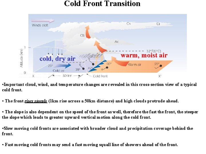
Cold Front Transition cold, dry air warm, moist air • Important cloud, wind, and temperature changes are revealed in this cross-section view of a typical cold front. • The front rises steeply (1 km rise across a 50 km distance) and high clouds protrude ahead. • The slope is also dependent on the speed of the front as well, therefore the fast the front, the steeper the slope which leads to greater upward vertical motion along the cold front. • Slow moving cold fronts are associated with broader cloud and precipitation coverage behind the front. • Fast moving cold fronts may send a fast moving squall line of showers ahead of the front.

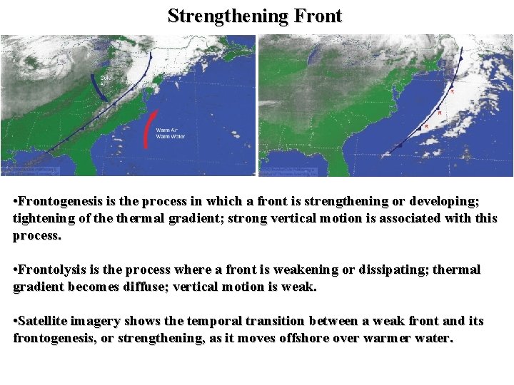
Strengthening Front • Frontogenesis is the process in which a front is strengthening or developing; tightening of thermal gradient; strong vertical motion is associated with this process. • Frontolysis is the process where a front is weakening or dissipating; thermal gradient becomes diffuse; vertical motion is weak. • Satellite imagery shows the temporal transition between a weak front and its frontogenesis, or strengthening, as it moves offshore over warmer water.

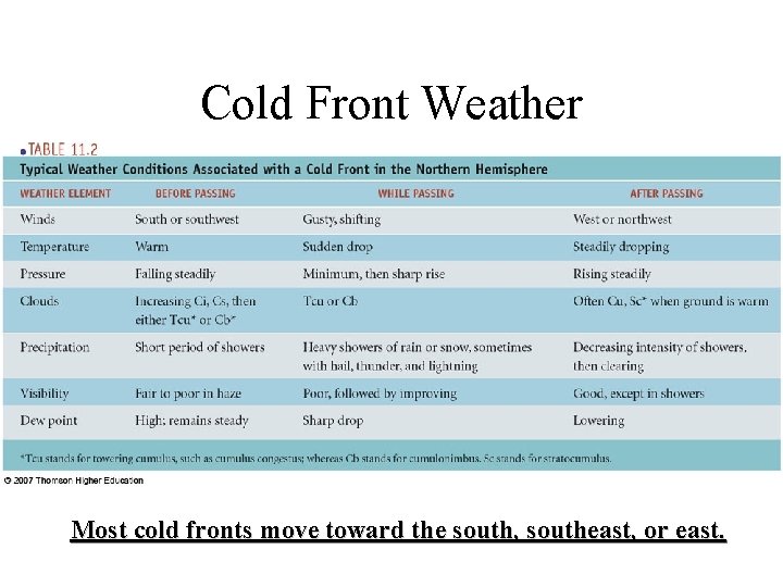
Cold Front Weather Most cold fronts move toward the south, southeast, or east.

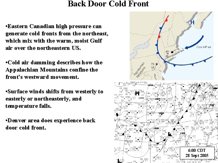
Back Door Cold Front • Eastern Canadian high pressure can generate cold fronts from the northeast, which mix with the warm, moist Gulf air over the northeastern US. • Cold air damming describes how the Appalachian Mountains confine the front's westward movement. • Surface winds shifts from westerly to easterly or northeasterly, and temperature falls. • Denver area does experience back door cold front. 6: 00 CDT 28 Sept 2005

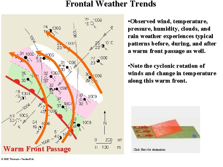
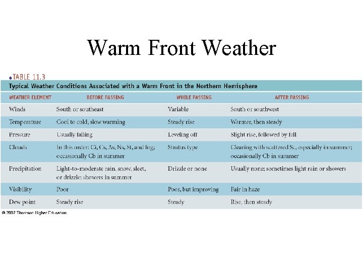
Frontal Weather Trends • Observed wind, temperature, pressure, humidity, clouds, and rain weather experiences typical patterns before, during, and after a warm front passage as well. • Note the cyclonic rotation of winds and change in temperature along this warm front. Warm Front Passage Click Here for Animation

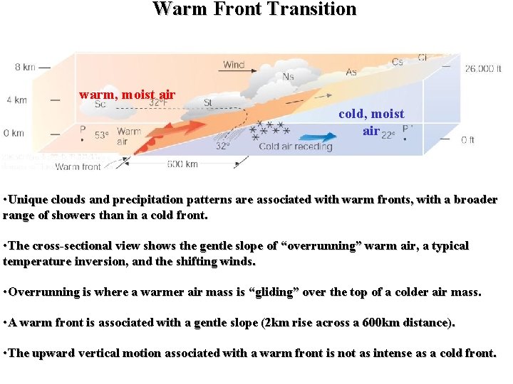
Warm Front Transition warm, moist air cold, moist air • Unique clouds and precipitation patterns are associated with warm fronts, with a broader range of showers than in a cold front. • The cross-sectional view shows the gentle slope of “overrunning” warm air, a typical temperature inversion, and the shifting winds. • Overrunning is where a warmer air mass is “gliding” over the top of a colder air mass. • A warm front is associated with a gentle slope (2 km rise across a 600 km distance). • The upward vertical motion associated with a warm front is not as intense as a cold front.

Warm Front Weather

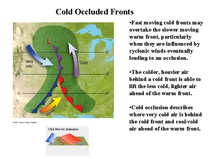
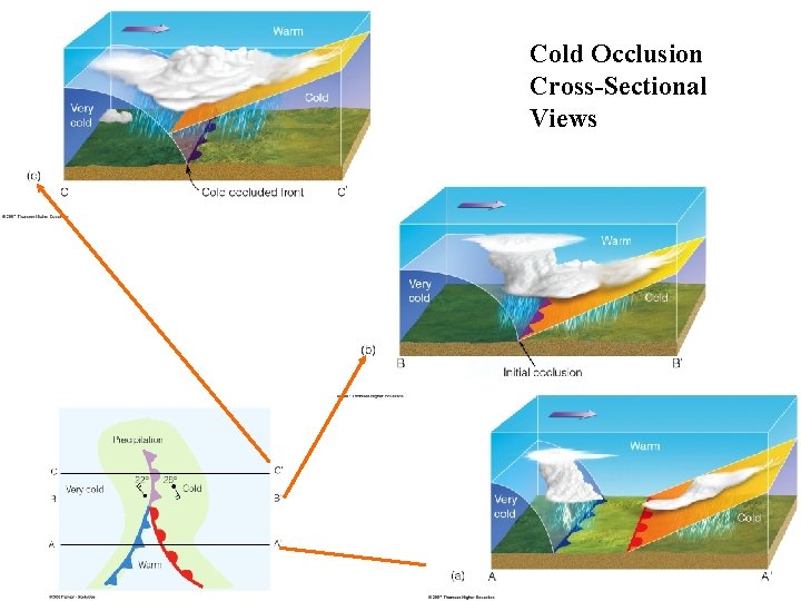
Cold Occluded Fronts • Fast moving cold fronts may overtake the slower moving warm front, particularly when they are influenced by cyclonic winds eventually leading to an occlusion. • The colder, heavier air behind a cold front is able to lift the less cold, lighter air ahead of the warm front. Click Here for Animation • Cold occlusion describes where very cold air is behind the cold front and cool/cold air ahead of the warm front.

Cold Occlusion Cross-Sectional Views

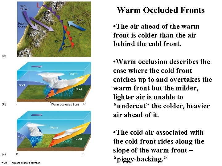
Warm Occluded Fronts • The air ahead of the warm front is colder than the air behind the cold front. • Warm occlusion describes the case where the cold front catches up to and overtakes the warm front but the milder, lighter air is unable to “undercut” the colder, heavier air ahead of it. • The cold air associated with the cold front rides along the slope of the warm front – “piggy-backing. ”

Occluded Front Weather

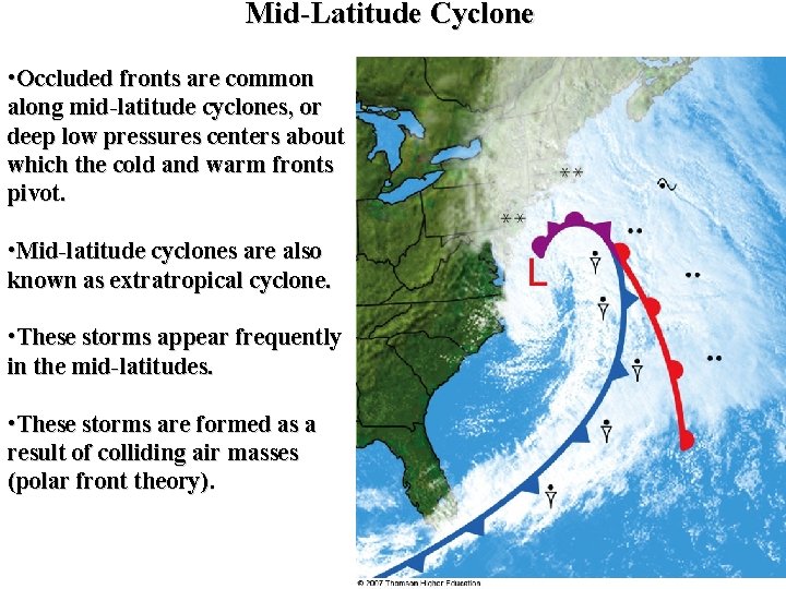
Mid-Latitude Cyclone • Occluded fronts are common along mid-latitude cyclones, or deep low pressures centers about which the cold and warm fronts pivot. • Mid-latitude cyclones are also known as extratropical cyclone. • These storms appear frequently in the mid-latitudes. • These storms are formed as a result of colliding air masses (polar front theory).

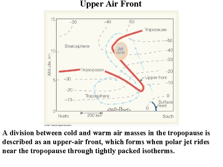
Upper Air Front A division between cold and warm air masses in the tropopause is described as an upper-air front, which forms when polar jet rides near the tropopause through tightly packed isotherms.

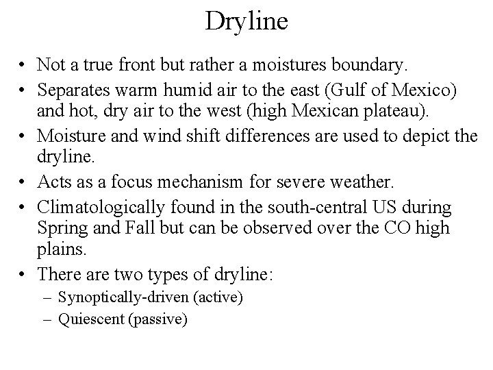
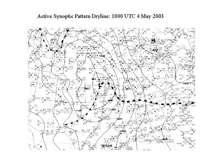
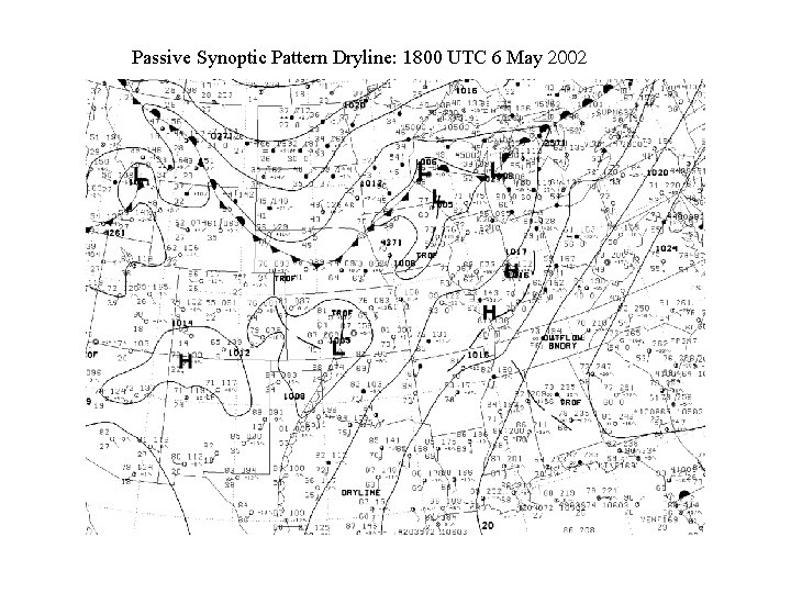
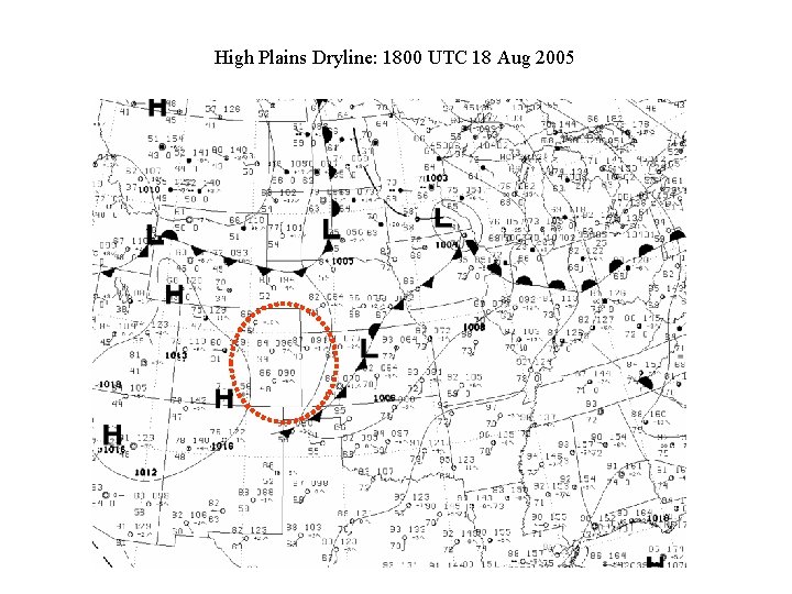
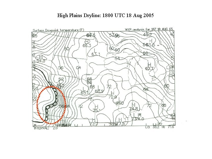
Dryline • Not a true front but rather a moistures boundary. • Separates warm humid air to the east (Gulf of Mexico) and hot, dry air to the west (high Mexican plateau). • Moisture and wind shift differences are used to depict the dryline. • Acts as a focus mechanism for severe weather. • Climatologically found in the south-central US during Spring and Fall but can be observed over the CO high plains. • There are two types of dryline: – Synoptically-driven (active) – Quiescent (passive)

Active Synoptic Pattern Dryline: 1800 UTC 4 May 2003

Passive Synoptic Pattern Dryline: 1800 UTC 6 May 2002

High Plains Dryline: 1800 UTC 18 Aug 2005

High Plains Dryline: 1800 UTC 18 Aug 2005