Air Masses Fronts and Global Wind Patterns Meteorology

Air Masses, Fronts and Global Wind Patterns Meteorology

Syllabus March April May State Lab Exam May 20 -22 State Written Exam June 1 Chapter 9 Meteorology Chapter 8 Astronomy Completion of first practice exam found in your wkbk Due April 4/5 th Chapter 10 Geology Completion of Second Practice Exam due April 7 th. Chapter 11 Energy – Forces – Motion* Chapter 5 Physiology & Human Systems Chapter 6 Reproduction & Development Chapter 7 Genetics Chapter 3 Characteristics of Life / Cells Chapter 4 Ecology State Lab Review: Microscope Use, Making Microscope Measurements, Lab Skills on Measuring and Properties of Matter: Density, Volume, Mass, Speed and Momentum June Extra Final Topic and Review for Final!!!!

Station Plots http: //www. wpc. ncep. noaa. gov/html/stationplot. sht ml http: //reviewearthscience. com/subjects/es/review/to pic-spec/fronts. pdf

The Atmosphere l An ocean of air l Made of 4 layers: 1. 2. 3. 4. 5. Troposhere Stratosphere Mesophere Thermopshere Exosphere

Functions of Atmosphere l l l Protects us from meteors as they disintegrate It helps in absorbing heat energy from the Sun and Earth Contains the ozone created from oxygen made from photosynthesis millions of years ago Protects us from UV rays because of the ozone Chlorofluorcarbons (CFC), bromides and nitrogen oxides created by human activity are breaking down the Ozone. l This can cause increased cases of skin cancer, and inhibit plant and animal life. Greenhouse gases keep the heat in l Green house gases: carbon dioxide, water vapor, methane

The Atmosphere continued. . l l l Stratosphere: dry, temperatures increase because of the ozone layer above. Ozone: absorbs ultraviolet light Mesophere: temperatures decrease, air very clean Thermosphere: meteors disintegrate at this level as altitude increases the air pressure and vapor pressure decrease

l How life began. . l l There was no life, oxygen, water vapor, or ozone Without an Ozone the planet was extremely hot. Volcanoes began to erupt creating CO 2 and water vapor. Clouds began to form creating precipitation. CO 2 was available for plant life!

Water Cycle

Functions of Atmosphere l l l Protects us from meteors as they disintegrate It helps in absorbing heat energy from the Sun and Earth Contains the ozone created from oxygen made from photosynthesis millions of years ago Protects us from UV rays because of the ozone Chlorofluorcarbons (CFC), bromides and nitrogen oxides created by human activity are breaking down the Ozone. l This can cause increased cases of skin cancer, and inhibit plant and animal life. Greenhouse gases keep the heat in l Green house gases: carbon dioxide, water vapor, methane

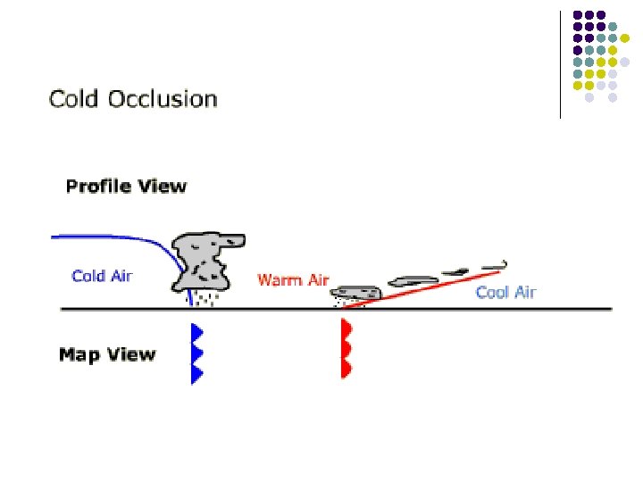
Fronts and their symbols

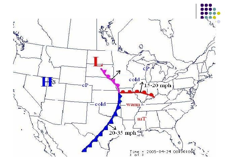
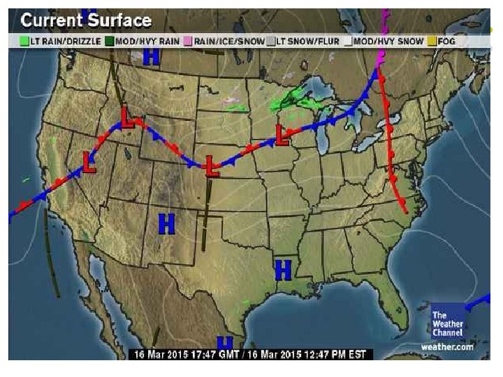
Fronts: l l l Boundary between two air masses Characterized by shift in weather There are 4 types each having different symbols § § Cold Warm Stationary Occluded

Characteristics of Cold Fronts 1. 2. 3. 4. 5. 6. 7. Temperature – drops rapidly Pressure – rises steadily (High pressure) Density – increases Clouds – yes, vertically moving up Precipitation – Heavy along front Winds – Strong and shifting Moves faster than warm front

Cold Fronts

In the summer, cold fronts can trigger: l l thunderstorms large hail dangerous winds tornadoes

Cold Front 1. Which compass direction is the cold front going? ______ 2. What is occurring along the boundary of the warm and cold front? ____ 3. Why is the warm front moving north? ________

Warm Fronts

Characteristics of a Warm Front 1. 2. 3. 4. 5. 6. 7. Temperature – rises slowly Pressure – slight rise, then fall Density – low Clouds – strato- and cirro. Precipitation – long, steady Winds – variable and light Typically will have affect for days

Warm Front 1. Which compass direction is the warm front moving? ______ 2. How do you know this? ______ 3. What is occurring along the boundary of the warm and cold front? ____ 4. Would the precipitation be a long or short storm? ________

Effects of warm fronts l l Slow-moving warm front can mean days of wet weather before warm air Sometimes water vapor in warm fronts condense to produce § § rain snow sleet freezing rain

Stationary Front

Stationary Fronts • • Temperature – stagnent Precipitation – none Winds – variable and light Can last for days weeks

Occluded Fronts • Temperature – l l • • Warm – gets milder Cold – gets colder Precipitation – steady and light Winds – variable and light

Different Temperatures Different Pressures Less Dense Cool Air Low Pressure Denser Warm Air High Pressure

High and Low Pressure Systems

Air Pressure Systems: H on a map represents a High Pressure System Weather: l Occurs when: cool dry temperatures which are dense pushes a warm front up! l Creates: cool clear calm dry air sunny skies L on a map represents a Low Pressure System Low Pressure: l Occurs when: warm moist air will rise and cool resulting in clouds and precipitation. l Creates precipitation

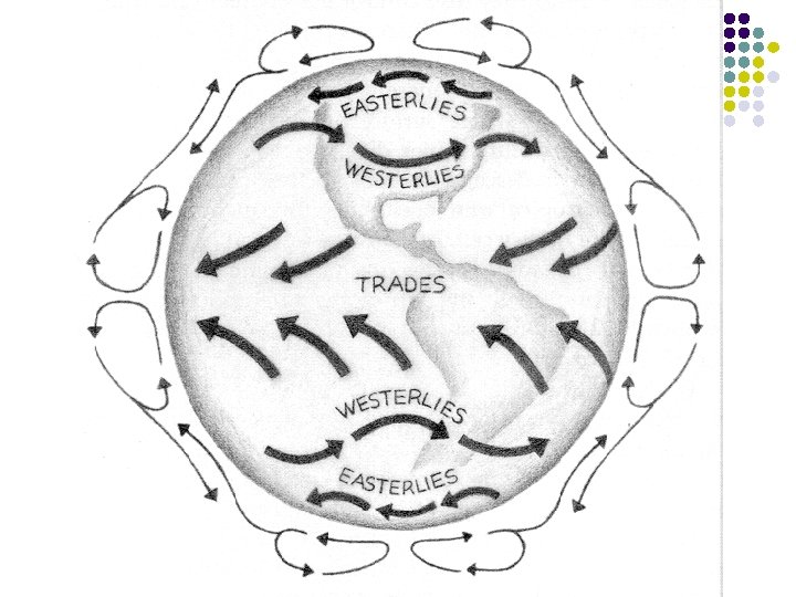
Pressure and Air Movement

Isobaric Maps

Isobars l Lines that indicate the difference in pressure over a given location--between isobars, any location on the same line has the same air pressure. § § § • Lines that are close together = STRONG winds Lines farther apart = Light winds Each line represents a measurement of air pressure which are the same https: //www. youtube. com/watch? v=wl_FFK_Hbj. Y

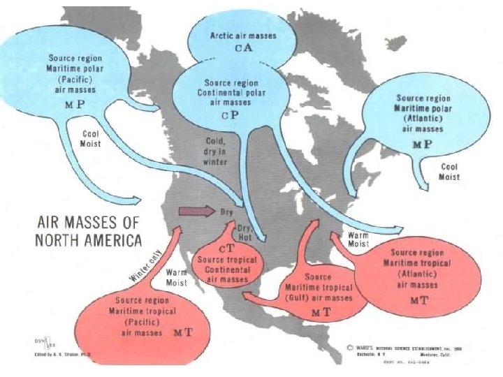
Air Masses

Air Masses: Air mass - a large region of air which has similar temperature and moisture characteristics throughout. What will make the air mass dry or moist? l l l Whether the air mass forms over a body of land or water it will be either dry(land)or wet(water). What will make the air mass cold or warm? l l Whether the air mass forms over a the tropics or over the arctic locations, the mass will be (cold or warm.
: • • Frigid Dry Dense - very high barometric pressure")
Continental Arctic (c. A): • • Frigid Dry Dense - very high barometric pressure Usually originate north of the Arctic Circle
: • • Cold and dry Usually originates in NW Territory")
Continental polar (c. P): • • Cold and dry Usually originates in NW Territory of Canada
: • • • Cool and moist Originate over N. Atlantic")
Maritime polar (m. P): • • • Cool and moist Originate over N. Atlantic and N. Pacific Main Influence - the Pacific Northwest and the Northeast.
: • • Warm and very moist Originate in the Gulf")
Maritime tropical (m. T): • • Warm and very moist Originate in the Gulf of Mexico and the Southern Atlantic Ocean
: • • Very Hot and very dry Originates in Desert")
Continental Tropical (c. T): • • Very Hot and very dry Originates in Desert Southwest and northern Mexico

Quick Write: Label Each box using the appropriate symbols for each type of Air Mass 12 3 1 4 6 7 8 5

Label Each box using the appropriate symbols for each type of Air Mass 12 c. A 3 c. P 1 m. P 4 m. P 6 c. T 7 m. T 8 m. T 5 m. T

Fill out the table below using the above map Number Air Mass Symbol Air Mass Name Air Masse Weather Condition 1 m. P Maritine polar Moist cold 2 c. A Continental arctic Dry frigid 3 c. P Continental polar Dry cold 4 m. T Maritine tropical Moist warm 5 c. T Continental tropical Dry warm

Fill out the table below using the above map Number 1 2 3 4 5 Air Mass Symbol Air Mass Name Air Masse Weather Condition

What is a Topographic Map? l l A topographic map is a representation of the Earth It shows the shape of the Earth's surface with the use of contour lines/isolines. Contours are imaginary lines that join points of equal elevation on the surface of the land These lines help to measure the height of mountains, depths of the ocean bottom, and steepness of slopes.

LOOK AT THE HIGHLIGHTE D AREAS, WHAT DOES IT TELL YOU? Topographic Maps

January Global Pressure Map January

July Global Pressure Map July
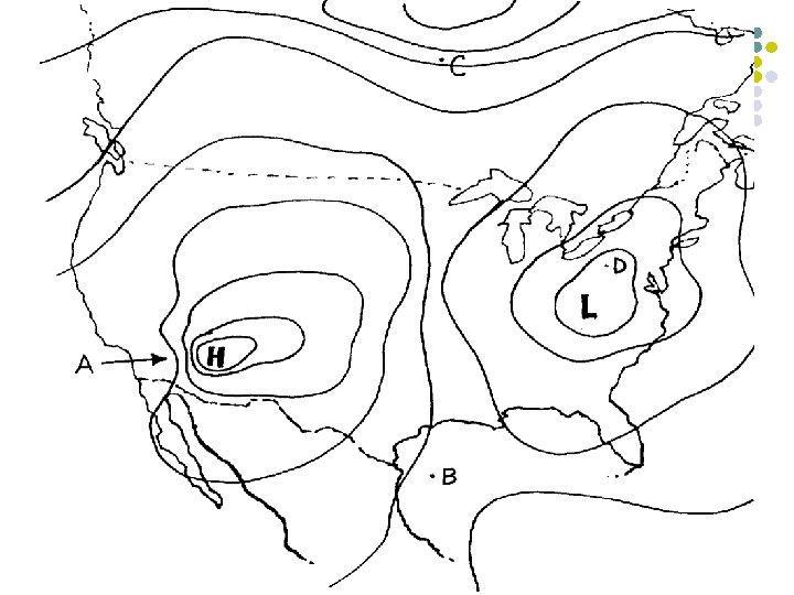

Quiz Questions: 1. 2. 3. 4. Where would you expect there to be the strongest winds? Why? Where would you expect there to be the calmest winds? Where would you expect clear, cool skies? Where would you expect cloudy skies with the greatest potential for precipitation?
- Slides: 50