Air Masses and Fronts And precipitation Precipitation Precipitation


 • P – Polar (cold) •")

 air masses form")
 air masses form over warm areas")
 different")


- Slides: 29
Air Masses and Fronts And precipitation
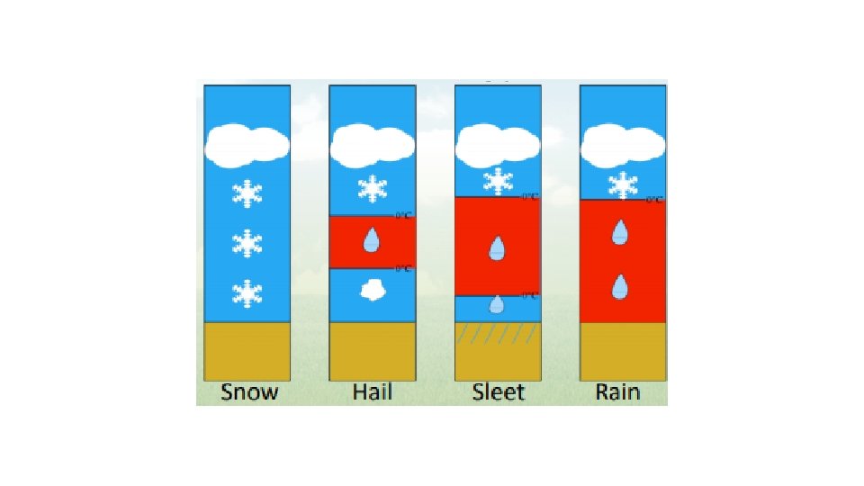
Precipitation • Precipitation is solid or liquid water that falls to Earth from clouds. • Four main types: • Rain, snow, sleet, and hail.
Precipitation • Rain - most common form of precipitation. • Sleet forms when rain falls through a layer of freezing air. • Snow forms when temperatures are so cold that water vapor changes directly to a crystalline solid. • Hail - balls or lumps of ice that fall from clouds.
Air Masses p 543 • An air mass is a large volume of air with constant temperature and moisture content. • Their movement and interaction cause changes in weather. • Classified by water content and temperature. • These features depend on where the masses form.
Source Region p 534 • A source region is the area over which an air mass forms. • Eg. One source region is the Gulf of Mexico. • Air masses that form over this source region are wet and warm.
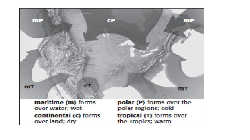
Naming Air Masses • Air masses are abbreviated with two letters: • 1 st letter: describes water content • c – Continental (dry; forms over land) • m – Maritime (wet; forms over ocean)
Naming Air Masses 2 nd letter: describes temperature: T = Tropical P = Polar A = Arctic
Source Region • A – Arctic (very cold) • P – Polar (cold) • T – Tropical (warm) • E – Equatorial (very warm) • M – Monsoon They can be combined in various ways… • c. P (Continental Polar) – dry, cold • m. A (Maritme Arctic) – wet, very cold
Example • c. T stands for continental tropical • Air mass coming from tropical land areas. • In north America, these hot, dry air masses originate in the summer in the desert areas of southwestern United States.
Cold Air Masses in North America • Continental polar (c. P) air masses form over northern Canada. They bring extremely cold winter weather. In the summer, c. P air masses can bring cool, dry weather. • Maritime polar (m. P) air masses form over the North Pacific Ocean. They are cool and very wet. They bring rain and snow to the Pacific Coast in winter. They bring fog in the summer. • Maritime polar air masses also form over the North Atlantic Ocean. They bring cool, cloudy weather and precipitation to New England.
Warm Air Masses • Maritime tropical (m. T) air masses form over warm areas in the Pacific Ocean, the Gulf of Mexico, and the Atlantic Ocean. • They move across the East Coast and into the Midwest. In summer they bring heat, humidity, hurricanes, and thunderstorms to these areas. • Continental tropical (c. T) air masses form over deserts and move northward. They bring clear, dry, hot weather in the summer
Fronts p 547 • A Front is the area where two (or more) different air masses meet. • When air masses meet, the less dense air mass rises over the denser air mass. • Warm air is less dense than cold air. • Therefore, a warm air mass will generally rise above a cold air mass.
Fronts • Type of front is determined by and named for which air mass is advancing • Example: Cold front = cold air advancing • Four types:
Cold Fronts • A cold front forms when a cold air mass moves under a warm air mass. • The cold air pushes the less dense warm air up. • The warm air cools to its dew point and clouds form. • Cold fronts move quickly and bring heavy precipitation. • They cause abrupt changes in weather, including thunderstorms.
Cold Front • After a cold front has passed, the weather is usually cooler. • This is because a cold, dry air mass moves in behind the cold front.
Cold Fronts
Warm Fronts • Warm fronts form when a warm air mass moves over cold, denser air. • If the warm air mass is humid, precipitation will fall: • If it is dry, scattered clouds will form. • Followed by clear, warm weather
Warm Fronts • Warm fronts form where warm air moves over cold, denser air. If the warm air mass is humid, precipitation will fall: if it is dry, scattered clouds will form.
Occluded Front An occluded front forms when a warm air mass is caught between two colder air masses. Cool temperatures and large amounts of rain and snow.
Occluded Front • Occluded Front Forms when a warm air mass is caught betw een two colder air masses. An occlude d front has cool temperatures and large amounts of rain and snow.
Stationary Front A Stationary Front forms when a cold air mass meet s a warm air mass, but neit her has the force to move t he other. Often brings many days of cloudy, and/or wet weather
Stationary Front • Sta>onary Front Forms when a cold air mass meets a warm air mass, but neither has the force to move the other. A sta*onary front o[en brings many days of cloudy, and/or wet weather.
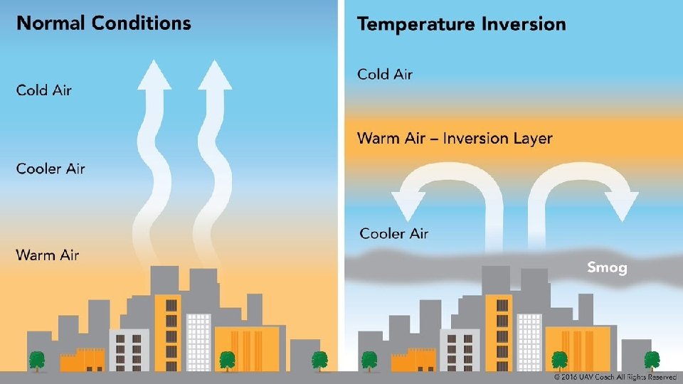
Temperature inversion • Normally air gets colder with height in the troposphere. • Temperature inversion occurs when a layer of cool air at the surface is covered by a layer of warmer air. • Form during clear, dry nights, when the ground air cool rapidly.
Temperature Inversion
Effects of Temperature Inversions • Smoke and other pollution are trapped beneath the inversion - making sky hazy, sunsets red. • Inversions cause clouds just below the inversion to spread out and take on a flattened appearance. • Temperature Inversions prevent thunderstorms from forming by keeping the warm, moist air from rising.
Practice • Read pages 543 -545 • Answer page 546 #1 -4 • Read pages 547 -549 • Answer p 549 #6, 7