Air Masses and Fronts Air Mass Huge bodies

Air Masses and Fronts

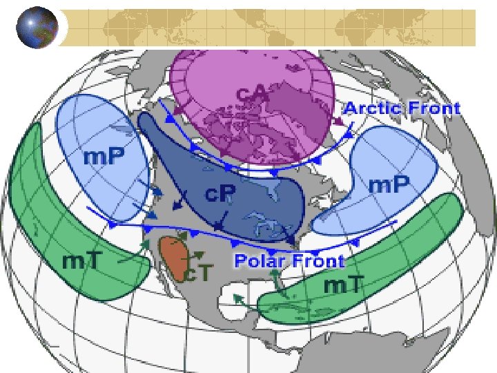
Air Mass Huge bodies of air that can cover entire continents or oceans The air masses takes the characteristics of the land below it.

Characteristics of Air Masses Maritime-Wet or Humid Continental- Dry Tropical- Warm or Hot Polar- Cold Arctic- Freezing

Characteristics of Air Masses are categorized by the amount of moisture and the temperature of the air mass. Maritime Tropical (m. T)- Wet and Warm Continental Polar (c. P)- Dry and Cold

What type of Air Mass Would You Expect Here?

What type of Air Mass Would You Expect Here?

What type of Air Mass Would You Expect Here?

What type of Air Mass Would You Expect Here?

Complete Air Masses Assignment

Fronts The point where two air masses collide The more dense air always goes underneath. Cold air is more dense than warm air. Wet Air is more dense than dry air.
 warm front B) cold front C) Stationary")
Frontal Lifting Four types of fronts: A) warm front B) cold front C) Stationary front D) Occluded front

Fronts Assignment In your Table Group, Complete your “Fronts” Assignment” Each Person is responsible for one front. We will do the occluded front.

Frontal Lifting Cold Front: When a cold air mass moves into a warm air mass. Cold, denser air forces the warm air up where it cools and condenses, forming clouds

Cold Front: Warm air is abruptly pushed upward, cooling, condensing moisture.

Cold Front Notice how steep the angle is between the two air masses Typically brings sudden, heavy rains and storms
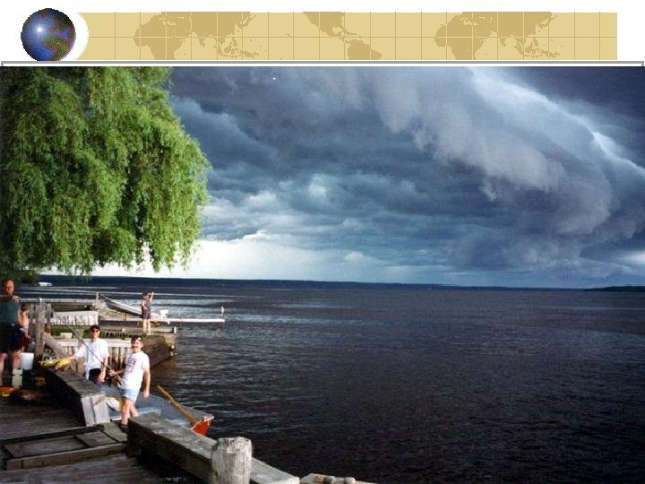

Cumulonimbus: Lake Superior

Warm Front WARM FRONT: when a warm air mass moves into a colder, denser air mass. Warm air rides up and over the colder air

Warm front

Warm Front Notice the angle of slope between the two air masses.

Warm Front The weather during a WARM FRONT starts with cirrus clouds about 24 -48 hours before the rain begins Cirrus clouds are “at the front of the front”

Warm Front As more warm air is pushed upward, more moisture condenses forming cirrostratus clouds

Cirrostratus on Lake Superior

Warm Front As warm more warm air is pushed up, heavier clouds form mid-way up over the cold air Altostratus and stratus

Altostratus clouds: Lake Superior

Warm Front The final cloud type in a warm front is the nimbostratus “nimbo” = “rain”

Warm Front Warm front: rain or snow is steady over several hours or days

Stationary Front Stationary Two air masses meet and neither move forward.

Stationary Front Weather Patterns Cloudy, Wet weather that last for days

Stationary Front Weather Patterns Two air masses meet and neither move forward.

Occluded Front Occluded Two cold air masses squeeze a warm air mass up.

Occluded Front Occluded Rain happens on both sides of the front.

Quiz Yourself!!! T or F

QUIZ: T or F For clouds to form, air must be lifted There are FOUR different types of lifting Orographic lifting refers to air moving up and over a mountain

QUIZ: T or F Convectional lifting is the circulation of warm air rising, cold air sinking A rain shadow is caused by WET air descending down the leeward side of a mountain A WARM FRONT means warm air is riding up over cold air A WARM FRONT produces sudden, severe rain and storms

Severe Weather

Thunderstorms Cold Fronts Begins with humid air rising, cooling, and condensing into a single cumulus cloud. Cloud builds as they are “fueled” by warm, moist air from below.

Thunderstorms The droplets of water grow larger until they are so big that they fall as rain.

Cumulonimbus clouds: L Superior
 Lightning may be associated with T. storms Hits Earth 100 times per")
Thunderstorms (con’t) Lightning may be associated with T. storms Hits Earth 100 times per second Over 200 people in the US die each year from lightning.

Lightning is the cause of thunder returns nitrogen to the soil may cause fires May have helped start prebiotic formation of amino acids(? )

Lightning Formation During thunderstorms strong updrafts cause molecules to bump together and their charges to separate Negative charges concentrate at the base of the clouds
 charge Opposites")
Lightning Formation The ground has lost electrons, giving it a positive (+) charge Opposites attract: The (-) from the cloud base is “pulled” to the (+) First downward movement of (-) is called a leader
 and (+) touch, they create a conductive path to")
Lightning Formation When the (-) and (+) touch, they create a conductive path to the ground. The other (-) rush down this path = lightning

Lightning on L. Superior

Lightning on L. Michigan

Lightning strike

Quiz Yourself!! TRUE or FALSE

TRUE or FALSE? ? ? Cumulonimbus clouds can become thunderstorms Stratus clouds produce sudden, severe thunderstorms and lightning Lightning forms because of unequal charges

Tornadoes A funnel shaped cloud that extends downward from a cumulonimbus cloud. Called a tornado only once it hits the ground. Winds inside travel at up to 800 km per hour in counterclockwise direction.

Hurricanes Caused by a warm, vertical wind interacting with an existing storm and causing the storm to turn inward and spiral. Wind speeds of up to 300 km per hour. Hurricanes grow as more moist air rises into it. Severe winds rotate around a calm, low pressure zone in the middle, which is the eye of the storm.
- Slides: 52