AICE Marine Science Objective 6 The Ocean Floor

AICE Marine Science Objective #6: The Ocean Floor & the Coast Tectonic processes & the ocean basin. The littoral zone.
 Describe theory of plate tectonics & the evidence supporting theory. In 1912, the")
(a) Describe theory of plate tectonics & the evidence supporting theory. In 1912, the geologist Alfred Wegener proposed theory of continental drift. He suggested that many millions of years ago, there was just one land mass, referred to as Pangaea, which slowly separated to form today’s land masses. In the 1960 s, this theory was extensively revised & is now known as theory of plate tectonics. This theory suggests that the outer crust of the Earth, known as the lithosphere, consists of a number of separate plates which ‘float’ on the underlying layer (the asthenosphere). These plates move slowly relative to each other. Where plates move in relation to another, there are three different types of boundaries between them known as convergent, divergent & transform boundaries. Earthquakes, mountain building, volcanic activity & the formation of ocean trenches all occur along these plate boundaries. Evidence supporting theory of plate tectonics includes fit between coastlines (for example the east coast of South America and the west coast of Africa); palaeontology showing the distribution of fossil species; magnetic stripes in the ocean floor. The pattern of magnetic stripes provides clear evidence of ocean floor spreading.
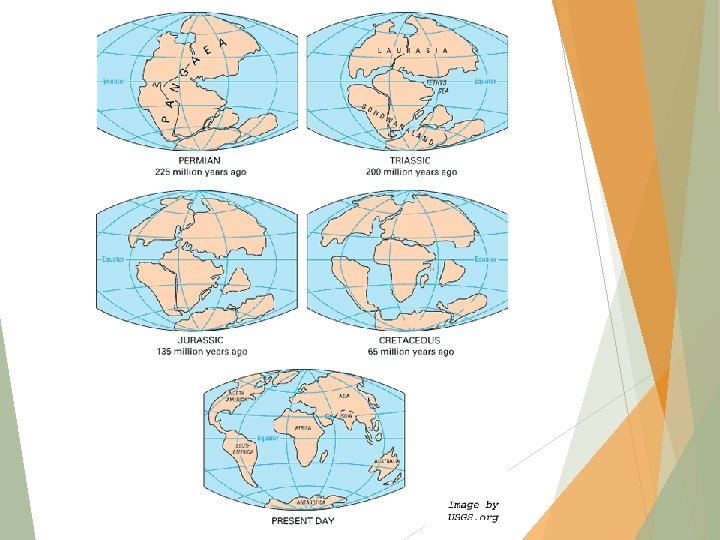

Plate Boundaries What is occurring at the boundaries of the Ring of Fire? What type of plate movement is associated with mid-ocean ridges?

Divergent Convergent Transform • Plate Movement Caused by Two Forces Plates slide off the ridges of spreading centers. Plates are pulled downward into the mantle by their cool, dense leading edges.

Fossil evidence- first observed by Suess

Paleomagnetism
 Relate tectonic processes to the production of ocean trenches, mid-ocean ridges, hydrothermal vents,")
(b) Relate tectonic processes to the production of ocean trenches, mid-ocean ridges, hydrothermal vents, abyssal plains, volcanoes, earthquakes & tsunamis. Ocean trenches are formed along tectonic plate boundaries where one plate is forced under another plate (subduction). Ocean trenches are long and narrow & are the deepest part of the ocean floor, for example, the Challenger Deep in the western Pacific Ocean is approximately 10 000 m below sea level. Mid-ocean ridges are underwater mountain ranges, formed by upward movement & spreading of the underlying magma, which cools & solidifies as it emerges. This process occurs at a divergent tectonic plate boundary & is responsible for seafloor spreading. Hydrothermal vents occur in the deep ocean, typically along mid-ocean ridges where two tectonic plates are diverging. Sea water which seeps into cracks in the ocean floor (& water from the upwelling magma) is released from the hot magma. Hydrothermal vents occur at depths of about 2100 m below sea level. Abyssal plains are relatively flat areas of the ocean floor, situated between ocean trenches & continental rises. An abyssal plain is formed by the upwards movement of molten material from the oceanic crust, which solidifies & forms new ocean crust. This process is referred to as mantle convection. The abyssal plain arises as the uneven rock surface becomes covered with fine-grained sediments. Abyssal plains have a depth of between about 3000 & 6000 m below sea level.
 cont’d A volcano is formed where there is an opening in the Earth’s")
(b) cont’d A volcano is formed where there is an opening in the Earth’s crust, allowing hot gases & molten rock to escape from beneath the surface. Volcanoes can form where there is thinning of the crust at tectonic plate boundaries, for example at divergent plate boundaries. Volcanoes can also be formed where tectonic plates are moving towards each other, or converging. Most divergent tectonic plate boundaries are under the sea and therefore most volcanic activity is submarine. This results in the formation of new seafloor. Divergent tectonic plate boundaries also give rise to midocean ridges; where these rise above sea-level, volcanic islands may be formed, such as Iceland. An earthquake occurs when there is a sudden release of energy in the Earth’s crust, creating seismic waves. Earthquakes can arise from convergent tectonic plate boundaries. If the two plates are unable to slip past each other, they may lock. Continued plate movement results in strain building up until the plates suddenly move again, releasing stored energy & creating an earthquake. Sudden tectonic plate movement can also give rise to tsunamis. A tsunami is a long wavelength wave produced by the sudden movement of a very large volume of water. This may occur at a convergent tectonic plate boundary, where the abrupt slippage of one plate against another results in both an undersea earthquake & a tsunami. In deep, oceanic water, a tsunami wave travels quickly. As the wave approaches shallow, coastal water, it slows down but forms large, destructive waves.

• In some cases, one of the plates is subducted. The subducting plate’s downward movement causes earthquakes and volcanic eruptions. 1. Oceanic – Continental Crust Collisions o Oceanic is always subducted due to its higher density. o Produces continental volcanoes like those of the Pacific Northwest.

2. Oceanic – Oceanic Crust Collisions o Oldest, densest plate is subducted. o Produces volcanoes that form islands in an arc around the boundary called an island arc. Ex: Japanese Islands
 o.")
3. Continental – Continental Crust Collisions o. Neither is subducted. (Why not? ) o. Both are compressed, folded, & uplifted, producing mountain ranges. Ex: Himalayas in China

Know this figure! Found on page 94 of your book.
 Explain why the water coming from hydrothermal vents is under pressure, hot &")
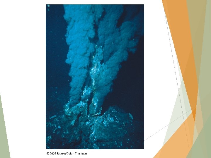
c) Explain why the water coming from hydrothermal vents is under pressure, hot & rich in minerals. Hydrothermal vents (Figure 6. 1) were discovered in 1977. They are formed along divergent plate tectonic boundaries in the deep ocean. Cold sea water seeps into cracks & fissures along these boundaries & is heated by the hot underlying magma under the ocean floor. The hot water is forced back up to the ocean floor, carrying dissolved minerals. A hydrothermal vent forms where the hot water passes up through the ocean floor &, as it cools, the dissolved minerals start to precipitate out. Minerals in a hydrothermal vent include sulphides of iron, copper & zinc. Hydrothermal vents are found at depths of over 2000 m, where the pressure is very high (in excess of 200 atmospheres or 20 megapascals). Due to this high pressure, the water in a hydrothermal vent may be superheated & reach temperatures higher than 100˚C.
 Explain how isostasy may produce shallow seas within or at the edge of")
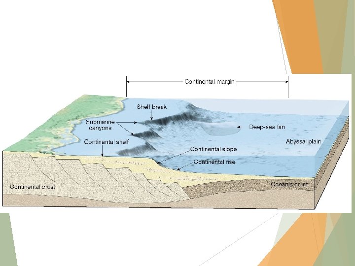
(d) Explain how isostasy may produce shallow seas within or at the edge of continents. The term isostasy literally means ‘weighing the same’. When applied to geology, it refers to the buoyant properties of layers of rocks which float on other layers, according to their density & thickness. This explains why the Earth’s crust floats on the denser, underlying layer, just as an ice cube floats in a glass of water. The continental shelf is a gently sloping region surrounding the continents, over which the sea is relatively shallow. The continental shelf is covered with sediments, derived from erosion of the continents. The continental shelf is part of the continent itself & was above sea level during the ice age, when the sea level was lower than at present. The depth of water over the continental shelf depends upon two main factors, isostatic changes in land height & changes in sea level. The principle of isostasy shows that the Earth’s crust is generally higher where it is thicker & less dense; lower where it is thinner & denser. The density of the continental crust is less than that of the oceanic crust. These figures support the fact that the continental crust & the oceanic crust float on the mantle, which has the highest density.
 Demonstrate an understanding of the processes of erosion & sedimentation that give rise")
(e) Demonstrate an understanding of the processes of erosion & sedimentation that give rise to the morphology of the littoral zone, including rocky shores, sandy shores, muddy shores, estuaries & deltas. The littoral zone can be defined as the area of a coast between the high water mark & the lowest part of the shore which is permanently submerged. The littoral zone is, therefore, part of the sea shore, the area where the land meets the sea. Sea shores vary from steep, rocky areas to large expanses of mud flats. The nature of the shore depends on two main factors: the geology of the adjacent land & the exposure to erosion by the sea. Rocky shores are characterised by outcrops of rock which are exposed to erosion by the sea, producing a variety of different sized boulders, stones & pebbles. Some types of rock, such as granite, are resistant to weathering & break down less easily than softer rocks, such as sandstone. On many rocky shores, the repeated pounding effect of the sea grades the rocks according to size with the largest boulders being left at the top of the shore. The slope of rock shores varies widely, from those which are very steep where cliffs drop into the sea, to those which are almost horizontal, where flat rocks form a wave-cut platform. Rocky shores are the most exposed type of shore & the most resistant to erosion.
 cont’d Sandy shores can be formed by erosion of sandstone rock & deposition")
(e) cont’d Sandy shores can be formed by erosion of sandstone rock & deposition of sand by the sea itself. Sandy shores consist of small, hard rock particles of silica & other minerals. Sandy shores usually slope gradually towards the sea. Muddy shores are the least exposed to erosion & fine particles of silt can settle. The silt particles include very fine mineral sediments & organic remains. Muddy shores usually have little slope &, in some areas, form expansive ‘mud flats’.
 cont’d An estuary may be defined as a semi-enclosed coastal body of water,")
(e) cont’d An estuary may be defined as a semi-enclosed coastal body of water, which has a connection with the sea & within which sea water is diluted with fresh water derived from land drainage. Many estuaries have a muddy substrate as the relatively slow flow of water allows fine suspended particles to settle. Deltas are formed when a river carrying suspended sediments reaches a large body of water, such as a lake or an ocean. As the river increases in width, the flow rate of water decreases &, as a result, the suspended sediments settle. Over a long period of time, the sediments accumulate to form a wide, fan-shaped structure. Within the delta, the river may divide up to form a number of distributary channels. Deltas are so-called because of the similarity of their shape to the Greek letter delta (Δ). Notable deltas include the Nile River Delta & the Mississippi River Delta.
 Demonstrate an understanding of how environmental factors influence the formation of ecological communities")
(f) Demonstrate an understanding of how environmental factors influence the formation of ecological communities in the littoral zone, including mangrove, sandy shore & rocky shore. Mangroves are trees & shrubs that grow in tropical & subtropical saline coastal habitats, usually between latitudes 25˚ N & 25˚ S. These form woodland or a shrubland habitat, in coastal or estuarine conditions where sedimentation of silts occurs. The habitat itself is referred to as a mangrove swamp, mangrove forest, or simply mangrove. Mangroves are specifically adapted to a wide range of salinity & low oxygen concentrations in the sediments. They have, for example, specially adapted root-like structures (called pneumatophores) which obtain oxygen directly from the air. The extensive root systems of mangroves help to trap particles suspended in the water & reduce water flow which increases the deposition of sediments. The root systems & accumulated sediments provide habitats for a wide variety of other organisms, including algae, oysters, crabs, barnacles & other crustaceans, sponges & fish. The root system of mangroves also dissipates wave energy & thus helps to protect coastal areas from erosion.
 cont’d Sandy shores are relatively unstable as the fine mineral particles are easily")
(f) cont’d Sandy shores are relatively unstable as the fine mineral particles are easily moved by winds & tides. Sand does not provide a suitable substrate for the attachment of sea weeds, for example, & does not provide shelter for organisms living on the surface. However, a number of burrowing organisms are associated with sandy shores & include ghost crabs, bivalve molluscs, & annelid worms such as ragworms & lugworms. On coasts where sand is mixed with muddy deposits, the substrate is more stable & supports a wider range of organisms. Rocky shores support a wide range of organisms, as the relatively stable substrate of large rocks & stones provides a firm surface for the attachment of many species of algae & animals such as molluscs & cnidarians (including sea anemones). Rock pools retain water when the tide retreats & may support a wide range of different species. Rocky shores often show clear zonation of different species, which many appear in distinct bands along the shore. This is associated with their resistance to desiccation. Those living near the top of the shore are exposed to the air for longer periods of time when the tide goes out, than those lower down on the shore. Those organisms living near the top of the shore adapted to withstand longer periods of exposure to the air. Environmental factors that influence communities on a rocky shore include desiccation, temperature, wave action, light intensity, aspect, slope & the nature of the substrate.

Classification of an intertidal community on a steep, sandy beach

Zonation of a rocky shore, intertidal community
- Slides: 24