Africa Do you recognize this location Geography Africa


,")


 • On the coast")


 • Ghana was the earliest")


 • Mali was located")

 Songhai centered around the city of")


- Slides: 26
Africa
Do you recognize this location?
Geography • Africa is made up of several regions, including the Sahara and Sub-Sahara. • The Sahara is a desert; it takes up ¼ of the African continent. • The Sub-Sahara is a plateau. • Important rivers in Africa include the Congo, Niger and Zambezi.
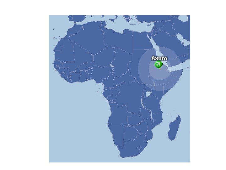
Kingdoms of Axum and Zimbabwe
Important Facts of Axum • Axum was an important African nation from about the 100 s A. D. until the 700 s A. D. - Axum straddled important trade routes – the Nile and the Ethiopian Highlands - Kush (neighboring kingdom) influenced Axum
• King Ezana converted to Christianity (in the 300 s A. D. ), helping Christianity to become a powerful influence in Africa. Christianity is the foundation for the Ethiopian Church. • Axum was a center of trade throughout East Africa. That brought great wealth.
The Fall of Axum • Axum declined in power for several reasons: a. Erosion made the land less productive b. Persians gained control of trade c. Islamic Arabs competed with Axum, which declined as a commercial power.
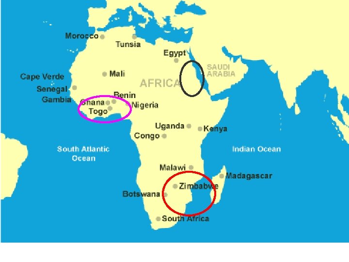
Zimbabwe (c. 1300 s to 1400 s A. D. ) • On the coast of East Africa, where Swahili is spoken, several powerful city-states arose. One was Zimbabwe: - located near the Zambezi and Limpopo Rivers - Important location for trade
• In Zimbabwe, they traded gold for essential goods. • Great Zimbabwe became the capital of this prosperous empire. • However, the population grew too fast, leading to dwindling supplies of food and water and the ultimate decline of Zimbabwe.
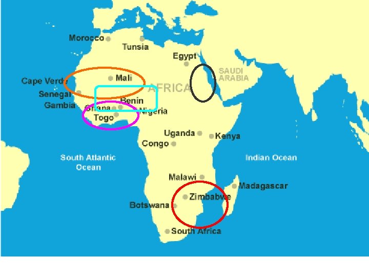
Kingdoms of Ghana, Mali and Songhai *Gold and salt were important to the trans-Saharan trade
Ghana (c. 300 s to 1235 A. D. ) • Ghana was the earliest of the West African kingdoms Ghana: located in West Africa, near the Niger River - It became powerful and wealthy from the gold trade. - the Soninke people influenced Ghana (b/c of trade)
• Eventually, the neighboring Malinke people overthrew Ghana and established Mali.
Mali (c. 1230 s to 1400 s A. D. ) • Mali was located near the Niger River. It participated in the same trade as Ghana. • Mali’s most important ruler was Mansa Musa. He was important because: a. He supported education, the arts and public building b. He helped make Timbuktu into a leading center of learning and trade c. He made a pilgrimage to Mecca (Muslim tradition)
The Fall of Mali declined in part because of arguments over Mansa Musa’s successor. Then, Sonni Ali (rebel leader) captured Timbuktu and built up Songhai.
Songhai (c. 1468 to 1591 A. D. ) Songhai centered around the city of Gao, near the Niger River. Sonni Ali and Mohammed I Askia built Songhai into a strong kingdom. Timbuktu was known as a city of trade. Internal conflicts weakened the kingdom. Troops from Morocco destroyed the empire.
Trade
Trade Routes and Patterns • Many trade routes developed from Asia to Europe. These trade routes included: a. The Silk Road which stretched from China, across Asia to the Mediterranean basin b. Maritime routes across the Indian Ocean c. Trans-Saharan routes across North Africa d. Links from N. Europe to the Black Sea e. River and sea routes across W. Europe f. Routes between the South China Sea and southeast Asia
• These trade networks/routes aided in the exchange of goods, technology and ideas between Europe, Africa and Asia.
• Examples of goods exchanged include: a. Gold from West Africa b. Spices from lands around the Indian Ocean c. Textiles from India, China, the Middle East and later Europe d. Porcelain from China and Persia e. Amber from the Baltic region
• Examples of technology exchanged include: a. Paper from China through the Muslim world to Byzantium and Western Europe b. New crops from India (ex. For making sugar) c. Waterwheels and windmills d. Navigation – Compass from China, lateen sail from Indian Ocean
• Different religious ideas spread across the Eastern hemisphere. Ideas include: a. Buddhism from China to Korea and Japan b. Hinduism and Buddhism from India to Southeast Asia c. Islam into West Africa, Central and Southeast Asia 6. The ideas of printing and paper money also spread from China.