Aeolian Processes Landforms AEOLIAN ENVIRONMENTS Wind is a


 define four degrees of aridity: Index of aridity, defined as")


- Slides: 17
Aeolian Processes & Landforms
AEOLIAN ENVIRONMENTS Wind is a geomorphic agent in all terrestrial environments. üIt is a potent agent only in dry areas with fine-grained soils and sediments and little or no vegetation. üIt is limited by a protective cover of vegetation and moist soil, which helps to bind soil particles together Deserts are regions with very low annual rainfall, meagre vegetation, extensive areas of bare and rocky mountains and plateaux, and alluvial plains that cover about a third of the Earth’s land surface. In 1953, Peveril Meigs divided desert regions on Earth into three categories according to the amount of precipitation they receive: • extremely arid lands have at least 12 consecutive months without rainfall; • arid lands have less than 250 mm of annual rainfall; 3. semi-arid lands have a mean annual precipitation of between 250 and 500 mm.
Middleton and Thomas (1997) define four degrees of aridity: Index of aridity, defined as AI = PE/P where ; ØArid and extremely arid land are deserts; Øsemi-arid grasslands mostly prairies or steppes. PE is the potential evapotranspiration and P is the average annual precipitation
AEOLIAN EROSIONAL FORMS ØLandforms resulting from wind erosion are seldom preserved except in arid areas. ØIn alluvial plains and beaches, subsequent action by rivers and by waves erases traces of aeolian erosion. ØIn arid areas, other denudational agents are often weak or absent and fail to destroy erosional landforms.
Lag deposits and stone pavements Deflation winnows silt and fine sand, lowering the level of the ground surface and leaving a concentrated layer of rock and coarse sand that acts as a protective blanket. Such thin veneers of gravel, or coarser material, that overlie predominantly finer materials are called lag deposits. Where the stone cover is continuous (and the particles generally flat), surfaces covered by lag deposits are called stone pavements.
Deflation hollows and pans Deflation can scour out large or small depressions called deflation hollows or blowouts. Blowouts are the commonest landforms produced by wind erosion. They are most common in weak, unconsolidated sediments. v In size, they range from less than a metre deep and a few metres across, Pans are closed depressions that are common in many dryland areas and that seem to be at least partly formed by deflation. v. In size, they range from a few metres wide and only centimetres deep, to kilometres across and tens of metres deep.
Yardangs and Zeugen Yardangs are normally defined as spectacular streamlined, sharp and sinuous ridges that extend parallel to the wind, and are separated by parallel depressions. Two size classes are distinguished – ümega-yardangs and üyardangs. Zeugen (singular Zeuge), also called perched or mushroom rocks, are related to yardangs. They are produced by the wind eating away strata, and especially soft strata close to the ground.
Ventifacts Cobbles and pebbles on stony desert surfaces often bear facets called ventifacts. The number of edges or keels they carry is sometimes connoted by the German terms ØEinkanter (one-sided), ØZweikanter (two-sided), ØDreikanter (three-sided). The pyramid-shaped Dreikanter are particularly common.
AEOLIAN DEPOSITIONAL FORMS Sand accumulations come in a range of sizes and forms. Deposition may occur as sheets of sand (dune fields and seas) or loess or as characteristic dunes.
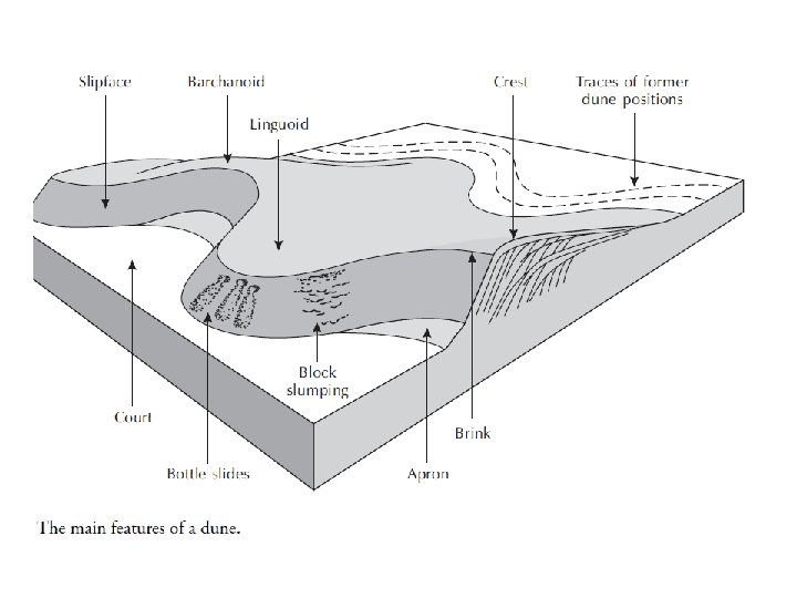
Dunes are collections of loose sand built piecemeal by the wind. They usually range from a few metres across and a few centimetres high to 2 km across and 400 m high. Sand dunes form where there is a source of sand. Dune sand is usually composed of quartz, which isextremely hard and doesn’t easily decay. Dune sand grains are beautifully rounded by abrasion. Ripples Wind ripples are the smallest aeolian bedform. They are regular, wavelike undulations lying at right-angles to the prevailing wind direction. The size of ripples increases with increasing particle size, but they typically range from about 10 to 300 mm high and are typically spaced a few centimetres to tens of metres. Wind ripples develop in minutes to hours and quickly change if wind direction or wind speed alters.
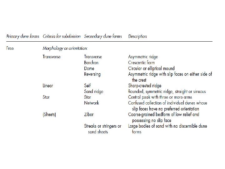
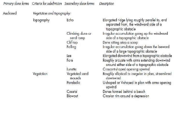
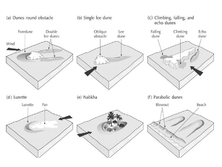
Free dunes may be classed according to orientation or form.
Loess is a terrestrial sediment composed largely of windblown silt particles made of quartz. It covers some 5– 10 per cent of the Earth’s land surface, much of it forming a blanket over preexisting topography that may be up to 400 m thick. To form, loess requires three things: (1) a source of silt; (2) wind to transport the silt; and (3) a suitable site for deposition and accumulation Vegetation surfaces encourage loess accumulation. Even so, for a ‘typical’ loess deposit to form, the dust must accumulate at more than 0. 5 mm/year,
The End