
Advanced GIS UNT Geography 2 Model Builder and
Advanced GIS UNT Geography ______________________________ 2. Model. Builder and Raster Data 2. 1 Model. Builder 2. 2 Raster data model 2. 3 Categorical rasters 2. 4 Continuous rasters 2. 5 Digital images 2. 6 Raster formats 2. 7 Raster naming conventions 2. 8 Raster vs. Vector
Advanced GIS UNT Geography ______________________________ 2. 1 Model. Builder
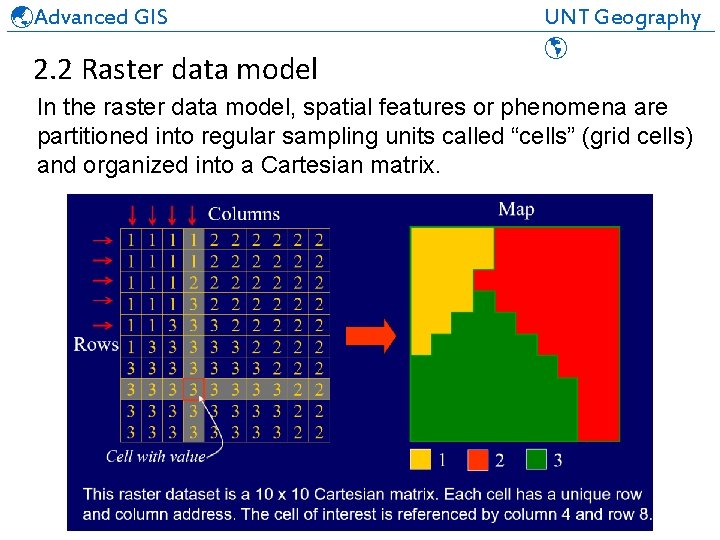
Advanced GIS UNT Geography ______________________________ 2. 2 Raster data model In the raster data model, spatial features or phenomena are partitioned into regular sampling units called “cells” (grid cells) and organized into a Cartesian matrix.
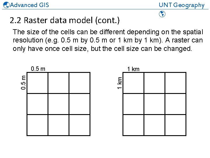
Advanced GIS UNT Geography ______________________________ 2. 2 Raster data model (cont. ) The size of the cells can be different depending on the spatial resolution (e. g. 0. 5 m by 0. 5 m or 1 km by 1 km). A raster can only have once cell size, but the cell size can be changed. 1 km 0. 5 m
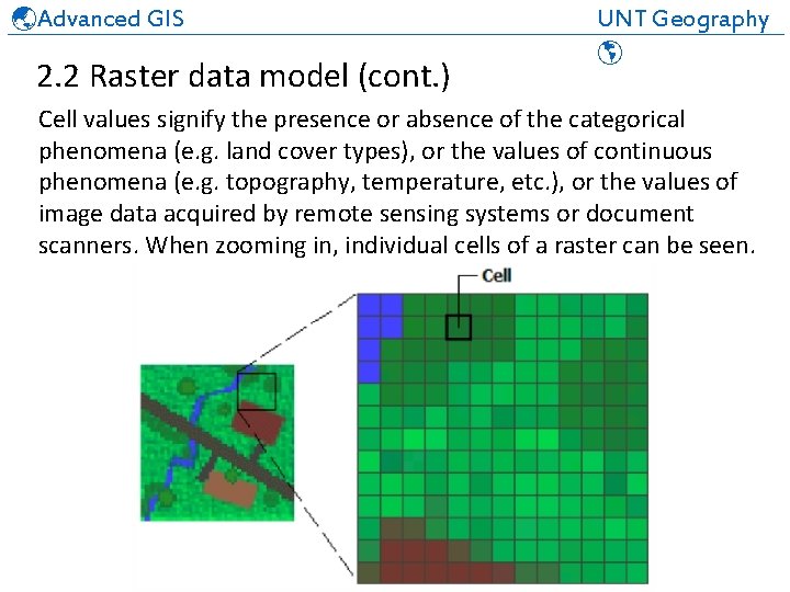
Advanced GIS UNT Geography ______________________________ 2. 2 Raster data model (cont. ) Cell values signify the presence or absence of the categorical phenomena (e. g. land cover types), or the values of continuous phenomena (e. g. topography, temperature, etc. ), or the values of image data acquired by remote sensing systems or document scanners. When zooming in, individual cells of a raster can be seen.
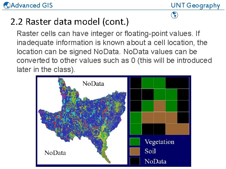
Advanced GIS UNT Geography ______________________________ 2. 2 Raster data model (cont. ) Raster cells can have integer or floating-point values. If inadequate information is known about a cell location, the location can be signed No. Data values can be converted to other values such as 0 (this will be introduced later in the class).
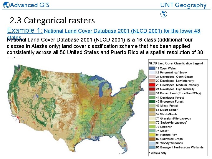
Advanced GIS UNT Geography ______________________________ 2. 3 Categorical rasters Example 1: National Land Cover Database 2001 (NLCD 2001) for the lower 48 states. National Land Cover Database 2001 (NLCD 2001) is a 16 -class (additional four classes in Alaska only) land cover classification scheme that has been applied consistently across all 50 United States and Puerto Rico at a spatial resolution of 30 meters.
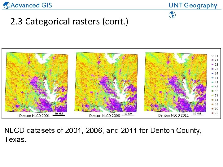
Advanced GIS UNT Geography ______________________________ 2. 3 Categorical rasters (cont. ) NLCD datasets of 2001, 2006, and 2011 for Denton County, Texas.
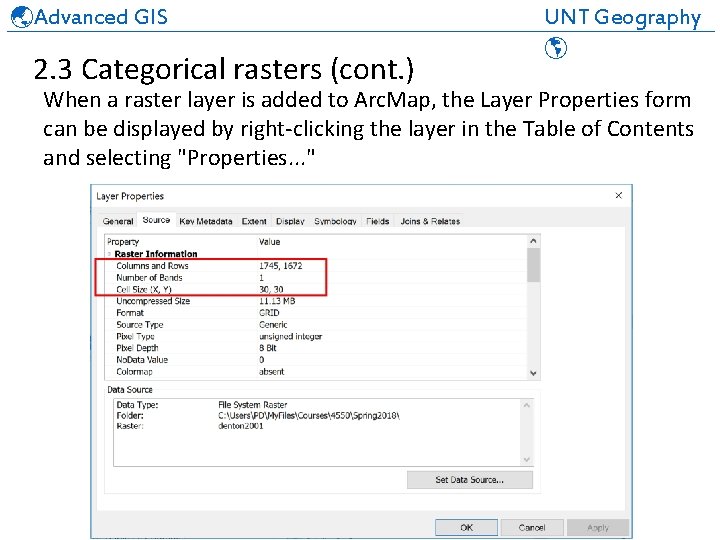
Advanced GIS UNT Geography ______________________________ 2. 3 Categorical rasters (cont. ) When a raster layer is added to Arc. Map, the Layer Properties form can be displayed by right-clicking the layer in the Table of Contents and selecting "Properties. . . "
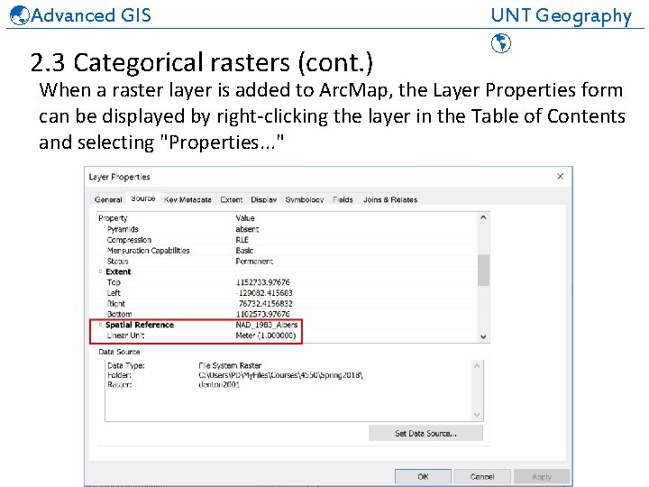
Advanced GIS UNT Geography ______________________________ 2. 3 Categorical rasters (cont. ) When a raster layer is added to Arc. Map, the Layer Properties form can be displayed by right-clicking the layer in the Table of Contents and selecting "Properties. . . "
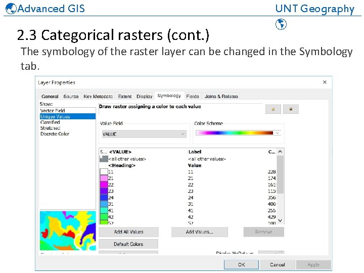
Advanced GIS UNT Geography ______________________________ 2. 3 Categorical rasters (cont. ) The symbology of the raster layer can be changed in the Symbology tab.
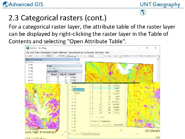
Advanced GIS UNT Geography ______________________________ 2. 3 Categorical rasters (cont. ) For a categorical raster layer, the attribute table of the raster layer can be displayed by right-clicking the raster layer in the Table of Contents and selecting "Open Attribute Table".
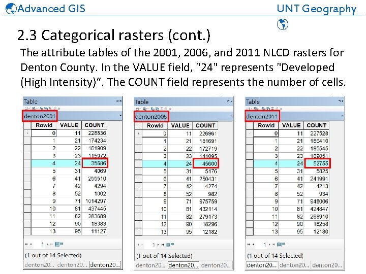
Advanced GIS UNT Geography ______________________________ 2. 3 Categorical rasters (cont. ) The attribute tables of the 2001, 2006, and 2011 NLCD rasters for Denton County. In the VALUE field, "24" represents "Developed (High Intensity)“. The COUNT field represents the number of cells.
Advanced GIS UNT Geography ______________________________ 2. 3 Categorical rasters (cont. ) Example 2: Binary raster data If cell values of 41 (Deciduous Forest) and 42 (Evergreen Forest) are reclassified as 1, and all other cell values are reclassified as 0, a binary raster can be produced where forests are shown as 1’s and non-forest areas as 0’s. Forest and non-forest areas of Denton County extracted from the NLCD 2011 data are shown on the next slide. Reclassification methods will be introduced later in the class.
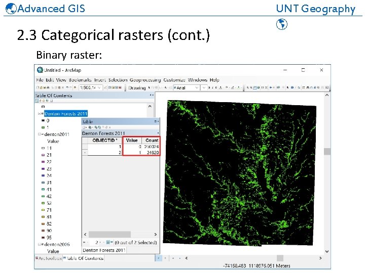
Advanced GIS UNT Geography ______________________________ 2. 3 Categorical rasters (cont. ) Binary raster:
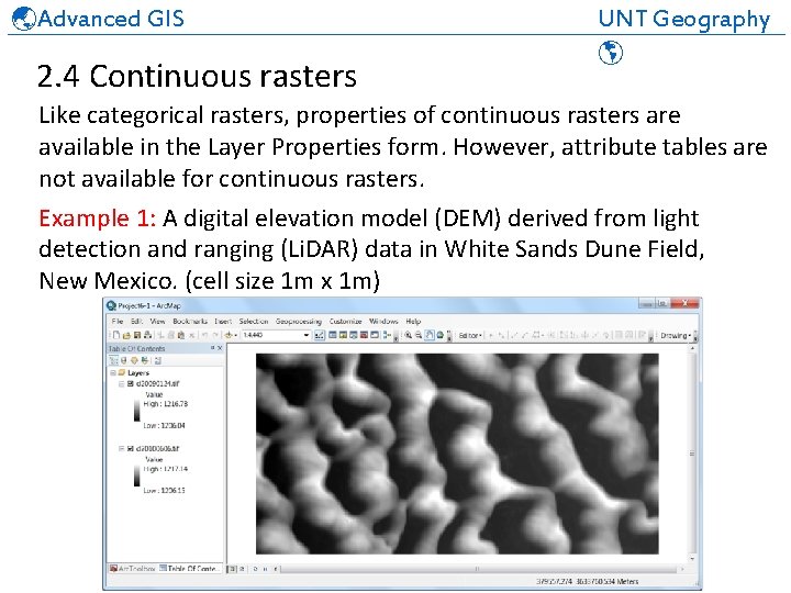
Advanced GIS UNT Geography ______________________________ 2. 4 Continuous rasters Like categorical rasters, properties of continuous rasters are available in the Layer Properties form. However, attribute tables are not available for continuous rasters. Example 1: A digital elevation model (DEM) derived from light detection and ranging (Li. DAR) data in White Sands Dune Field, New Mexico. (cell size 1 m x 1 m)
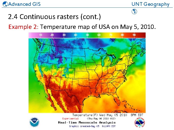
Advanced GIS UNT Geography ______________________________ 2. 4 Continuous rasters (cont. ) Example 2: Temperature map of USA on May 5, 2010.
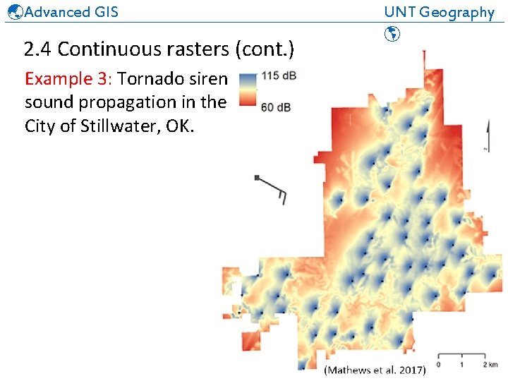
Advanced GIS UNT Geography ______________________________ 2. 4 Continuous rasters (cont. ) Example 3: Tornado siren sound propagation in the City of Stillwater, OK.
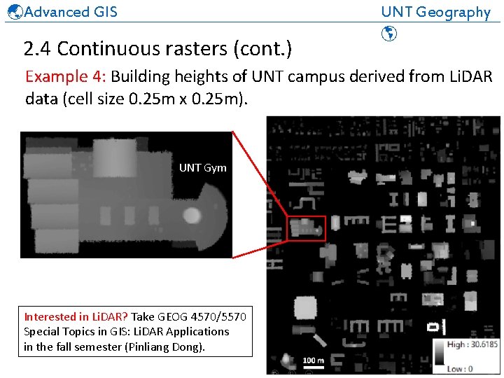
Advanced GIS UNT Geography ______________________________ 2. 4 Continuous rasters (cont. ) Example 4: Building heights of UNT campus derived from Li. DAR data (cell size 0. 25 m x 0. 25 m). UNT Gym Interested in Li. DAR? Take GEOG 4570/5570 Special Topics in GIS: Li. DAR Applications in the fall semester (Pinliang Dong).
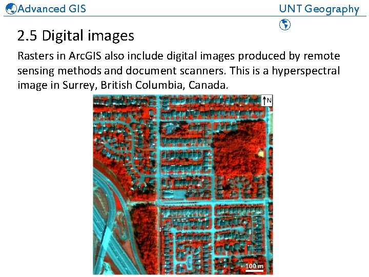
Advanced GIS UNT Geography ______________________________ 2. 5 Digital images Rasters in Arc. GIS also include digital images produced by remote sensing methods and document scanners. This is a hyperspectral image in Surrey, British Columbia, Canada.

Advanced GIS UNT Geography ______________________________ 2. 5 Digital images (cont. ) Rasters in Arc. GIS also include digital images produced by remote sensing methods and document scanners. This is a scanned map in the City of Denton, Texas.
Advanced GIS UNT Geography ______________________________ 2. 6 Raster formats GRID is a proprietary ESRI format that supports 32 -bit integer and 32 -bit floating point rasters. The 32 -bit integer grid values are from -2147483648 to 2147483647, and the floating-point grid values are from -3. 4 x 1038 to 3. 4 x 1038. More information on the GRID format can be found here. In addition to GRID, many other raster formats are supported by Arc. GIS. Click here to see a list of Arc. GIS-supported raster data file formats.
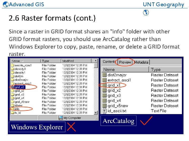
Advanced GIS UNT Geography ______________________________ 2. 6 Raster formats (cont. ) Since a raster in GRID format shares an "info" folder with other GRID format rasters, you should use Arc. Catalog rather than Windows Explorer to copy, paste, rename, or delete a GRID format raster.
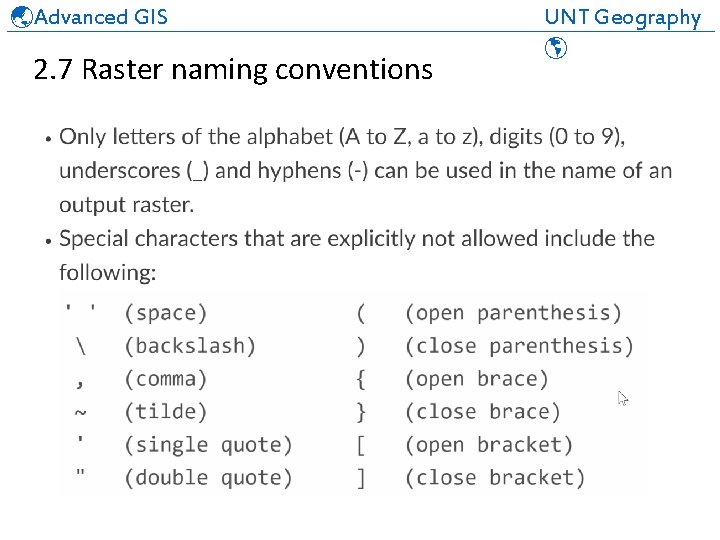
Advanced GIS UNT Geography ______________________________ 2. 7 Raster naming conventions
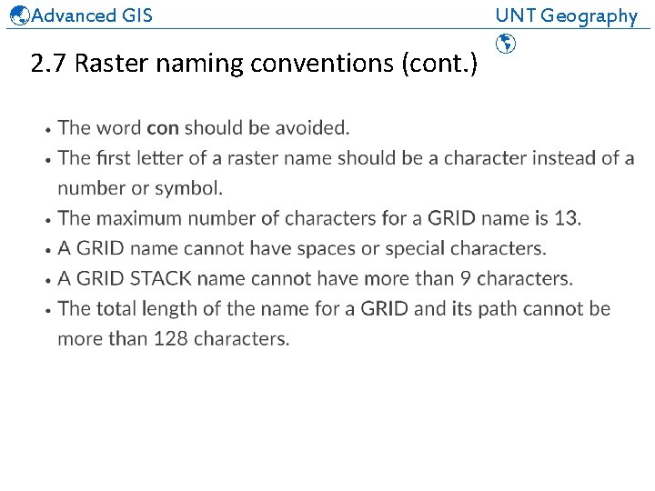
Advanced GIS UNT Geography ______________________________ 2. 7 Raster naming conventions (cont. )
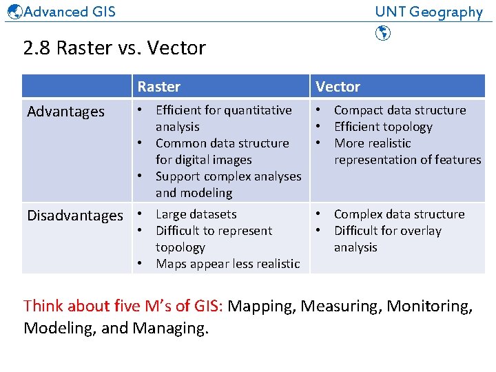
Advanced GIS UNT Geography ______________________________ 2. 8 Raster vs. Vector Raster Advantages Vector • Efficient for quantitative • Compact data structure analysis • Efficient topology • Common data structure • More realistic for digital images representation of features • Support complex analyses and modeling Disadvantages • Large datasets • Difficult to represent topology • Maps appear less realistic • Complex data structure • Difficult for overlay analysis Think about five M’s of GIS: Mapping, Measuring, Monitoring, Modeling, and Managing.
Advanced GIS UNT Geography ______________________________ Review 2. 1 Model. Builder 2. 2 Raster data model 2. 3 Categorical rasters 2. 4 Continuous rasters 2. 5 Digital images 2. 6 Raster formats 2. 7 Raster naming conventions 2. 8 Raster vs. Vector
- Slides: 27