Acid Rain Monitoring Update NYs Monitoring Program Federal


![ENVIRONMENTAL PROTECTION AGENCY 40 CFR Part 50 [EPA–HQ–OAR– 2007– 1145; FRL– 9654– 4] RIN](https://slidetodoc.com/presentation_image_h/92821169adc5ba3a437e0c6b4113a352/image-5.jpg "ENVIRONMENTAL PROTECTION AGENCY 40 CFR Part 50 [EPA–HQ–OAR– 2007– 1145; FRL– 9654– 4] RIN")
 Final Rule: “The intent of the AAI is to weight")


 used in Pilot to measure Atmospheric Ammonia • Passive,")
, NADP/NTN (●),")


 site operator sponsor VT")


- Slides: 23
Acid Rain Monitoring Update: NY’s Monitoring Program Federal Legislation EPA “Pilot” Monitoring Program DAR Management Meeting Albany, NY September 11 -13, 2012 NYS Department of Environmental Conservation
SO 2 Air Quality Standards • State SO 2 Air Quality Objective: 1964 – Primary 0. 1 ppm (24 -Hr) and 0. 25 ppm (1 -Hr) • State Acid Deposition Control Act (SADCA) set a Environmental Threshold Value (ETV) for sulfate deposition: 20 kilograms per hectare: 1984 • National SO 2 NAAQS established: 1971 – Primary 0. 03 ppm Annual and 0. 14 ppm (1 -Hr) – Secondary 0. 5 (3 -Hr) (Revoked in 1973) • Current SO 2 NAAQS – Primary 75 ppb (1 -Hr), Secondary: proposed in first multipollutant NOx/SOx standard NYS Department of Environmental Conservation
NYSDEC ‘s Acid Rain Monitoring Objectives • Provide a consistent, quality-assured, long-term acid deposition database. • Measure acid deposition in sensitive receptor areas. • Measure acid deposition in urban and upwind areas. (Architecture/Monument degradation was an important acid rain issue) • Use these data to perform spatial and temporal analyses of acid deposition, its precursors, and its effects. • Track the effectiveness of programs to reduce acid deposition precursor emissions. NYS Department of Environmental Conservation
ENVIRONMENTAL PROTECTION AGENCY 40 CFR Part 50 [EPA–HQ–OAR– 2007– 1145; FRL– 9654– 4] RIN 2060–AO 72 Secondary National Ambient Air Quality Standards for Oxides of Nitrogen and Sulfur EPA Proposed a first ever multipollutant NOx/SOx Secondary NAAQS using air quality indicators (SOx and NOy) with levels set appropriately for an ecological indicator: Acid Neutralizing Capacity AGENCY: Environmental Protection Agency (EPA). ACTION: Final rule. NYS Department of Environmental Conservation
Aquatic Acidification Index (AAI) Final Rule: “The intent of the AAI is to weight atmospheric concentrations of oxides of nitrogen and sulfur by their propensity to contribute to acidification through deposition, given the fundamental acidifying potential of each pollutant, and to take into account the ecological factors that govern acid sensitivity in different ecosystems. ” NYS Department of Environmental Conservation
AAI Links ANC to Air Indicators 22 of the 84 unique Ecoregions are acid sensitive • AAI is set to protect a percentage of sensitive water bodies • AAI is uniform nationally • F factors are used to account for physical and environmental differences between Ecoregion
F factors are Ecoregion Specific and require extensive monitoring and modeling • F 1 is the target ANC level plus the amount of deposition (critical load) the ecosystem can receive and still achieve the target level – Accounts for buffering capacity of soils / median runoff rate – Requires observations and modeling • F 2 is the amount of reduced nitrogen deposition within an ecoregion – incl. ammonia and ammonium / median runoff rate • F 3 and F 4 are transference ratios that convert ambient NOy and SOx to deposition of NOy and SOx • F 2 -F 4 based on CMAQ (due to lack of dry deposition measurements) NYS Department of Environmental Conservation
EPA “Pilot” Monitoring Objectives • Evaluate measurement methods for the ambient air indicators of NOy and SOx and consider designation as FRMs • Examine the variability and improve characterization of concentration and deposition patterns of NOy and SOx • Develop updated ecoregion specific factors (i. e. , F 1 through F 4) for the AAI equation based in part on new observed air quality data (relate air concentrations to water chemistry) • Calculate ecoregion specific AAI values and compare to a set of alternative AAI-based standards • Develop air monitoring network design criteria • Assess the use of total nitrate measurements as a potential alternative indicator for NOy • Evaluate modeled dry deposition algorithms • Facilitate stakeholder engagement in addressing implementation issues NYS Department of Environmental Conservation
The Pilot will use NADP’s 250+ sites for wet deposition measurements
NADP provides stable long term data necessary to detect wet deposition trends NYS Department of Environmental Conservation
CASTNET sites will be used in the Pilot to provide data to estimate dry deposition
CASTNET Filter Pack provides rural integrated gas and particle measurements
Ammonia Monitoring Network (AMo. N) used in Pilot to measure Atmospheric Ammonia • Passive, inexpensive samplers • Low cost, 2 week integrated sample (ug NH 3/m 3) • 1 EPA and 2 NYSDEC sites in Pilot (Huntington Forest, Nick’s Lake and Whiteface base)
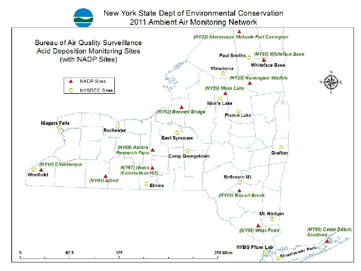
Current acid deposition monitoring in NY and surrounding region • DEC (▲), NADP/NTN (●), event-based NADP/AIRMo. N (■) • DEC 16, NADP NTN: 11 in NY, 8 in northern PA, 2 in VT, 1 in central MA • Existing NTN sites are rural; DEC sites a mix of rural, suburban, and urban NY 22 Paul Smiths Whiteface Mt. Wanakena Nick’s Lake NY 52 Rochester VT 99 (also an AIRMo. N site) NY 98 NY 20 NY 29 Piseco Lake Niagara Falls E. Syracuse VT 01 NY 08 Westfield Camp Georgetown Grafton NY 67 PA 30 Belleayre Mt. NY 01 NY 10 MA 08 Elmira NY 68 PA 90 Mt. Ninham PA 29 PA 21 PA 18 PA 52 PA 98 PA 72 NY 99 NY 96 Bronx (Pfizer) Eisenhower Park NYS Department of Environmental Conservation
Gaps in EPA Pilot program • The EPA plans to use one central site (Huntington Forest) to represent entire Adirondack Region – The site is not near heavily impacted/monitored water bodies • The NYSDEC plans to additional monitors in the Southwest Adirondack Park near sensitive lakes with long water quality records and in the Northeast corner to provide spatial variability. • The data used in the Pilot should cover areas with lakes that have a broad range of acid buffering capacity so we can evaluate proposed AAI standards • The CFP should be compared to continuous SO 2 measurements NYS Department of Environmental Conservation
Proposed changes to NYSDEC acid rain monitoring objectives • Maintain data coverage across the state with focus on rural and acid-sensitive regions (less focus on urban/suburban areas) • Support the secondary NOx/SOx 5 -year pilot project, focus is on Adirondack Mt region • Reduce redundant sampling by relying on existing NADP sites • Ensure consistent comparable acid deposition collection across the region/country (transition DEC to NADP NTN) NYS Department of Environmental Conservation
Proposed changes to NYSDEC Acid Deposition monitoring network • Close 10 DEC sites: Westfield, Elmira, Belleayre Mountain, Mount Ninham, Grafton, Whiteface Mountain (existing NTN), East Syracuse, Eisenhower Park, Nick’s Lake (only deposition), Camp Georgetown (no power currently) NY 22 • Convert 6 DEC monitors to NADP/NTN monitors Paul Smiths Wanakena Nick’s Lake NY 52 Rochester NY 98 VT 99 (also an AIRMo. N site) NY 20 NY 29 Piseco Lake Amherst VT 01 NY 08 NY 67 PA 30 NY 01 NY 10 MA 08 NY 68 PA 90 PA 29 PA 21 PA 18 PA 52 PA 98 PA 72 NY 99 NY 96 Bronx (Pfizer) Notes: • Whiteface Mountain: explore seasonal wet deposition at summit • Nick’s Lake and Whiteface will have CASTNET filter pack, AMon and continuous SO 2 • Moss Lake site (NY 29) is a NADP NTN site • Move Niagara Falls to Amherst NYS Department of Environmental Conservation
Conclusions • All sites within the State meet the original Sulfate threshold set in 1984 (Westfield close) • It is imperative that the Pilot accurately assess conditions in the Adirondack Region • NY State will be very well covered by 18 NADP sites (only Colorado has more at 19) • The continuous rural SO 2 monitors will be evaluated against the integrated CFP (continuous SO 2 monitors operate near detection limit in Adirondack region) NYS Department of Environmental Conservation
NADP NTN site operators and sponsors (as of August 2012) site operator sponsor VT 01 Bennington (city)/state of VT USGS VT 99 USGS/UVM-SAES USGS MA 08 UMass-SAES NESCAUM NY 01 Alfred Univ/USGS NY 08 Cornell-SAES Cornell/USDA NY 10 SUNY Fredonia/USGS NY 20 SUNY ESF/USEPA NY 22 Akwesasne Mohawk Tribe USEPA CAMD NY 29 NYSDEC USGS NY 52 SUNY Oswego USEPA CAMD NY 68 USGS NY 96 Suffolk Co DHS/USEPA NY 98 SUNY Albany USGS NY 99 Black Rock Forest Consortium/USGS PA 18 PSU USGS PA 21 N/A PA 29 Northeastern Research Station USFS PA 30 N/A PA 52 PSU PADEP PS 72 Pinchot Inst for Conservation USFS PA 90 PSU PADEP PA 98 N/A
NYS Department of Environmental Conservation
NYS Department of Environmental Conservation