A level assessment Component 1 Physical Geography Component


- Slides: 20
A level assessment Component 1 : Physical Geography Component 2: Human Geography Component 3: Geography fieldwork Investigation 40% Sect. A: Water & Carbon cycles 36 marks 40% Sect. A Global systems & Governance 36 marks 20% 60 marks Sect. B Coastal systems (or Sect. B Changing places hot desert or glacial) 36 marks Sect. C Hazards (or Ecosystems under stress) 48 marks Sect. C Contemporary urban Environments (or Population & the environment or Resource Scarcity) 48 marks
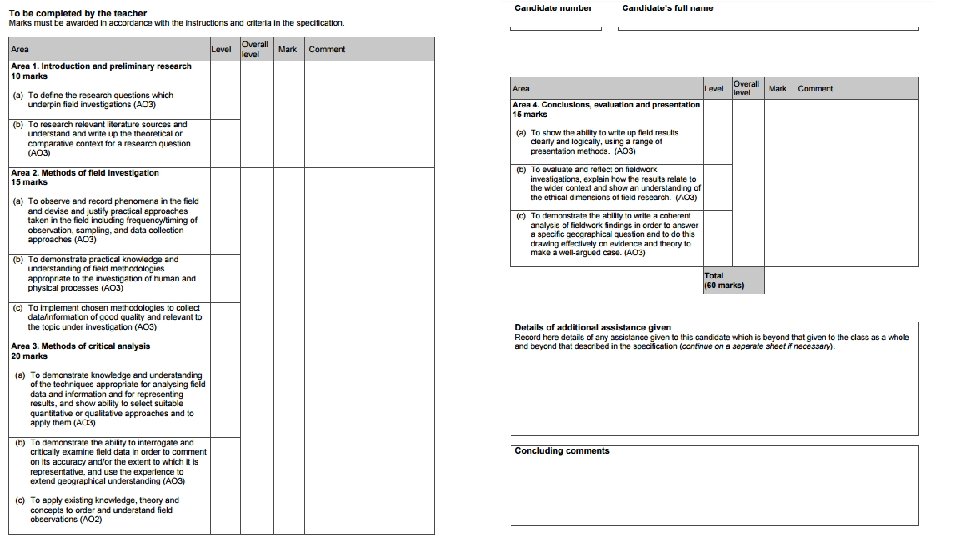
Component 3: Geography Fieldwork Investigation ‘Individual investigation which must include data collected in the field. …Must be based on a question or issue defined and developed by the student relating to any part of the specification’
How it’s assessed • 3000 -4000 words • 60 marks • 20% of A level • Marked by teachers • Moderated by AQA
Investigation requirements This must incorporate a significant element of fieldwork. The fieldwork undertaken as part of the individual investigation may be based on either human or physical aspects of geography, or a combination of both. They may incorporate field data and/or evidence from field investigations collected individually or in groups. What is important is that students work on their own on contextualising, analysing and reporting of their work to produce an independent investigation with an individual title that demonstrates required fieldwork knowledge, skills and understanding.
The independent investigation must: • be based on a research question or issue defined and developed by the student individually to address aims, questions and/or hypotheses relating to any part of the specification content • involve research of relevant literature sources and an understanding of theoretical or comparative context for a research question/hypothesis • incorporate the observation and recording of field data and/or evidence from field investigations that is of good quality and relevant to the topic under investigation • involve justification of the practical approaches adopted in the field including frequency/timing of observation, sampling and data collection approaches • draw on the student's own research, including their own field data and/or secondary data, and their experience of field methodologies of the investigation of core human and physical processes • demonstrate knowledge and understanding of the techniques appropriate for analysing field data and information and for representing results, and show ability to select suitable quantitative or qualitative approaches and to apply them • demonstrate the ability to interrogate and critically examine field data in order to comment on its accuracy and/or the extent to which it is representative, and use the experience to extend geographical understanding • require the student to independently contextualise, analyse and summarise findings and data, and to draw conclusions, by applying existing knowledge, theory and concepts to order and understand field observations and identify their relation to the wider context • involve the writing up of field results clearly, logically and coherently using a range of presentation methods and extended writing • demonstrate the ability to answer a specific geographical question drawing effectively on evidence and theory to make a well-argued case • require evaluation and reflection on the investigation including showing an understanding of the ethical dimensions of field research.
Independence • Some stages of the investigation must be carried out independently. Other parts of the investigation may be carried out collaboratively, either as a class, group or pair. Independence is compulsory in the following stages of the investigation: • defining and developing a question or issue to address aims, questions and/or hypotheses relating to any aspect of the specification • drawing on research, including field data and if relevant, secondary data which must be sourced by the student contextualising, analysing and summarising findings and data • presenting data and drawing conclusions. Collaboration is allowed in the following stages of the investigation: • exploring the focus of potential investigations • collecting field data and/or evidence from field investigations. • If students collaborate where independence is expected then the teacher must record this additional assistance on the Candidate record form (CRF) and take it into account when marking the work. You must award a mark which reflects the student’s unaided achievement. Failure to do so will be considered as malpractice. If malpractice is suspected, we will investigate. If malpractice is found to have taken place a penalty will be given dependent on the circumstances and severity of the malpractice.
• Preparation must involve enquiry work outside the classroom, to include data collection in the field and might include, for example, data collected in specialist study venues, work experience settings, internet research and use of library or archive. • Students are expected to submit a written report which is 3, 000– 4, 000 words in length. This includes all text, text boxes and supplementary material such as photographs and data presentation techniques. It does not include appendices. When attaching appendices students should have examples of raw data only, such as data sheets and questionnaires, rather than every questionnaire completed. • Students who offer work that is below the advisory word count may be penalising themselves by not allowing appropriate coverage of the required assessment objectives. Students who exceed the advisory word count may be penalising themselves through a lack of precision and focus.
Teachers should: • provide broad parameters for students’ investigation proposals (including themes from the specification, locations, availability of equipment, time constraints) • explain what independence means • advise on health and safety considerations, the use of equipment and potential ethical concerns • discuss with students their initial exploratory planning and tentative investigation titles • review each student’s independent investigation proposal. Within this review you should ensure that the proposed investigation can suitably access the specification requirements and you should give general guidance on the methodology and analytical tools that the student plans to use. • advise on good practice such as referencing and using a bibliography system. • The above advice does not need to be recorded or taken into account when marking the work.
Teachers must not: • provide students with a choice of titles or tasks from which they then choose • mark work provisionally and share that mark so that the student may then improve it • give specific guidance on how to make improvements to a draft in order to meet the assessment criteria without recording it as additional assistance on the Candidate record form (CRF) and taking it into account when marking the work. • These conditions apply equally to third party fieldwork providers. Failure to adhere to them constitutes malpractice. You must ensure that at all times you remain confident in the authenticity and independence of students’ work. Assistance that goes beyond general advice includes (but is not limited to): • providing templates or model answers for specific titles or students • providing specific guidance on how to improve an individual student’s draft to meet the assessment criteria so that the student is no longer engaged in independent learning providing specific guidance on errors and omissions which limits students’ opportunities to show initiative themselves • providing primary or secondary data not collected by the student either individually or as part of a group. • Any additional guidance of this nature must be recorded on the Candidate record form (CRF) and taken into account when marking the work. Annotation must be used to explain how marks were applied in the context of the additional assistance given. Failure to do so will be considered as malpractice.
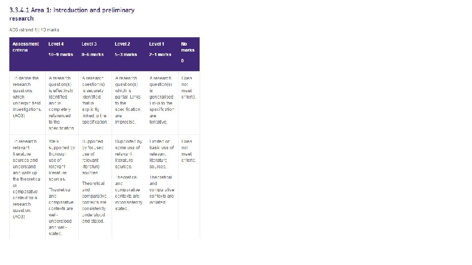
Non-exam assessment mark scheme guidance Level 4 • Detailed, effective, thorough, complete, well-developed. • The research question(s) will be effectively identified and preliminary research will be thoroughly undertaken with wellunderstood and well-stated contexts. • The methods of field investigation will be detailed and thorough with reasoned justification. • The methods of critical analysis will be effective, developed and complete. • The conclusions and evaluation will be thorough, effective and complete and the presentation will be logical and coherent. Level 3 • Clear, secure, explicit, focused, precise, consistent. • The research question(s) will be securely identified and preliminary research will be focused with consistently understood and stated contexts. • The methods of field investigation will be clear and relevant with explicit justification. • The methods of critical analysis will be clear, precise and consistent. • The conclusions and evaluation will be clear, secure and focused and the presentation will be clear and precise. Level 2 Intermittent, partial, some, implicit, imprecise, inconsistent. The research question(s) will be partial and preliminary research will be imprecise with inconsistently understood and stated contexts. The methods of field investigation will be intermittently applied with only some aspects justified. The methods of critical analysis will be imprecise, partial and inconsistent. The conclusions and evaluation will be partial and inconsistent and the presentation will be incomplete. Level 1 Basic, limited, tentative, generalised, isolated. The research question(s) will be generalised and preliminary research will be limited with only isolated contexts. The methods of field investigation will be basic and limited in scope with tentative justification. The methods of critical analysis will be basic, limited and tentative. The conclusions and evaluation will be limited and generalised and the presentation will be basic.
Qualitative skills and quantitative skills Students should develop the following with respect to qualitative data: use and understanding of a mixture of methodological approaches, including interviews interpretation and evaluation of a range of source material including textual and visual sources understanding of the opportunities and limitations of qualitative techniques such as coding and sampling, and appreciation of how they actively create particular geographical representations • understanding of the ethical and socio-political implications of collecting, studying and representing geographical data about human communities. • • • Students should develop the following with respect to quantitative data: • understanding of what makes data geographical and the geospatial technologies (eg GIS) that are used to collect, analyse and present geographical data • an ability to collect and use digital and geo-located data, and understand a range of approaches to use and analyse such data • understanding of the purposes and difference between the following and to use them in appropriate contexts: • • descriptive statistics of central tendency and dispersion descriptive measures of difference and association, inferential statistics and the foundations of relational statistics measurement, measurement errors, and sampling understanding of the ethical and socio-political implications of collecting, studying and representing geographical data about human communities.
3. 4. 2 Specific skills 3. 4. 2. 1 Core skills • Use and annotation of illustrative and visual material: base maps, sketch maps, OS maps (at a variety of scales), diagrams, graphs, field sketches, photographs, geospatial, geo-located and digital imagery. • Use of overlays, both physical and electronic. • Literacy – use of factual text and discursive/creative material and coding techniques when analysing text. • Numeracy – use of number, measure and measurement. • Questionnaire and interview techniques. 3. 4. 2. 2 Cartographic skills • Atlas maps. • Weather maps – including synoptic charts (if applicable). • Maps with located proportional symbols. • Maps showing movement – flow lines, desire lines and trip lines. • Maps showing spatial patterns – choropleth, isoline and dot maps. 3. 4. 2. 3 Graphical skills • Line graphs – simple, comparative, compound and divergent. • Bar graphs – simple, comparative, compound and divergent. • Scatter graphs, and the use of best fit line. • Pie charts and proportional divided circles. • Triangular graphs. • Graphs with logarithmic scales. • Dispersion diagrams. 3. 4. 2. 4 Statistical skills Measures of central tendency – mean, mode, median. Measures of dispersion – range, inter-quartile range and standard deviation. Inferential and relational statistical techniques to include Spearman’s rank correlation and Chi-square test and the application of significance tests. 3. 4. 2. 5 ICT skills Use of remotely sensed data (as described above in Core skills). Use of electronic databases. Use of innovative sources of data such as crowd sourcing and ‘big data’. Use of ICT to generate evidence of many of the skills provided above such as producing maps, graphs and statistical calculations.
Student investigation proposal
Coming up with a question…. Pick a topic of Geography that interests you. Ideally use the topics we have studied (AS) or intend to study (A 2) however you can also consider options that are available that we are not studying. Coastal systems & landscapes * Glacial systems & landscapes Hot desert systems & landscapes Water & Carbon Cycles * Global systems & Governance * Changing Places * Ecosystems under stress Contemporary urban environments * Hazards * Resource Scarcity Population & the environment
Broad parameters…. Topic areas accessible in our area Water Cycle: Investigations in to catchment dynamics- infiltration rates and slope (relief/soil type/geology), vegetation and runoff, land use and rainfall… Contemporary Urban Environments: Spatial patterns of land use/economic activity/inequality/social segregation, Urban forms & microclimates/weather conditions, Urban drainage basin systems, the Urban water cycle, spatial patterns of environmental problems, management strategies, green transport infrastructure Coastal Systems and landscapes: Processes and landforms of erosion/transport/deposition, beach profiles, Human value of coastlines, appropriateness of management, economic/social/environmental impacts of management Changing Places: Characteristics of a place over time/service provision, insider & outsider perspectives, changing infrastructure, assessment of the success or sustainability of redevelopment projects, impact of by-pass construction, changing quality of life, clone town investigation, impacts on residents, investigations of the impact of large employers, changing retail provision, success of rebranding
Equipment available • • • Consider what equipment you can manufacture/create…infiltr ation gauges, recording sheets with unique coding etc Metre rulers Clinometers Flow meter ID charts Rain gauge Range of recording sheets- bi-polar surveys/environmental quality Decibel recorder Ranging poles Measuring tapes Quadrats Compasses (orientation)
Secondary sources Coastal landscapes: • Historic photos/maps e. g. Old coastlines e. g Water cycle: Bing. com/maps • National River Flow Archive (river level data) • Geograph. org. uk- photos of every OS grid square • Environment Agency • Local authority websites • Met Office archive- monthly summaries • Local newspapers • British Geological Survey’s site Geology of Britain • Natural England (GIS) • Wildlife group sites • Environment. Contemporary Urban Environments: agency. gov. uk/research/planning/104939. aspx Shore • Index of multiple deprivation line management plans • • Neighbourhood statistic Zoopla Statistics. gov. uk Local. live. com- aerial photos and satellite images - land use/housing type & density Checkmyfile. com/postcode-check Apho. org. uk/resource- Health profiles Police. uk – Crime coverage Google. com/earth Changing Places: • Planning proposals/private scheme materials/consultation materials • Highways dept • Department for Transport statistics • House/land price data • Local press reports • Before/after photographs
Researching relevant literature/understanding theory • Starting point…if covered already- review your class notes and relevant articles • Geofactsheets • Wide World (available in Main Library) • New and historic text books- Waugh • Lancaster University Things to consider…. . Is there a model of theory against which you can test reality? Be mindful of what data could be appropriate- would it yield the opportunity for a statistical test?