A JOURNEY TO BETTERUNDERSTAND OCCUPANCY IDENTIFYING RENTAL PROPERTIES

A JOURNEY TO BETTER-UNDERSTAND OCCUPANCY IDENTIFYING RENTAL PROPERTIES TO TRACK HOUSING STABILITY IN DETROIT Noah Urban, Data Driven Detroit May 9 th, 2018

Some context

What do all of these buildings have in common?

The problem: 140, 000+: Renter-occupied housing units reported by ACS (including ~60, 000 in multifamily structures) 7, 750: Registered rental properties in Detroit (City file)

Scenario 1: Multifamily Rental Properties Where are they located in Greater Downtown Detroit?

Geocoding…lots of geocoding

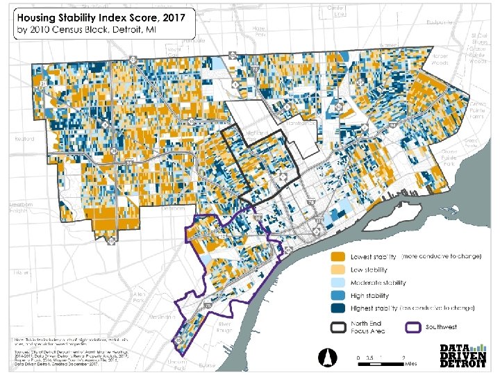
How are the data being used?

Scenario 2: 1 -4 Unit Rental Properties Where are they, and what condition are they in?

Background Desire to estimate the overall need for rehabilitation for 1 -4 unit rental properties Need to identify financing gaps and strategies

Initial research City tax emption data as a potential source? Only about 53, 000 habitable residential buildings in Detroit do not have a homestead exemption

A multiple-source approach Motor City Mapping � “Habitable Valassis � Between 1 and 4 Residential Addresses City of Detroit � Owner Structure” Address <> Property Address And others!

How are the data being used? Some quick findings to inform action: 99% built pre-1978 30% received a blight violation since 2005 22% are investor/speculator-owned 14% have no active utility customer service agreement

Additional Uses

www. Data. Driven. Detroit. org Noah Urban noah@Data. Driven. Detroit. org Looking for data? Ask. D 3@Data. Driven. Detroit. org @D 3 detroit
- Slides: 15