A DualWavelength SpaceAirborne Radar Technique to Detect Hydrometeor
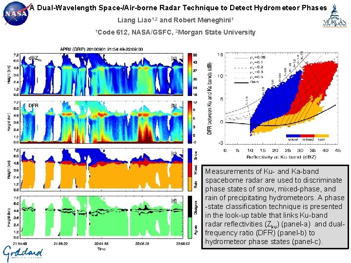
A Dual-Wavelength Space-/Air-borne Radar Technique to Detect Hydrometeor Phases Liang Liao 1, 2 and Robert Meneghini 1 1 Code 612, NASA/GSFC, 2 Morgan State University Measurements of Ku- and Ka-band spaceborne radar are used to discriminate phase states of snow, mixed-phase, and rain of precipitating hydrometeors. A phase -state classification technique is presented in the look-up table that links Ku-band radar reflectivities (Zku) (panel-a) and dualfrequency ratio (DFR) (panel-b) to hydrometeor phase states (panel-c).
Name: Liang Liao, NASA/GSFC, Code 612 / Morgan State University E-mail: Liang. Liao-1@nasa. gov Phone: 301 -614 -5718 References L. Liao and R. Meneghini, 2016: A Dual-Wavelength Radar Technique to Detect Hydrometeor Phases, IEEE Trans. Geosci. Remote Sens. , 54, 7292 -7298. doi: http: //dx. doi. org/10. 1109/TGRS. 2016. 2599022 Data Sources The Ku- and Ka-band radar measurements are taken by the Jet Propulsion Laboratory, California Institute of Technology, Airborne Precipitation Radar Second Generation (APR-2) during the 2003 Wakasa Bay field campaign and the 2010 Genesis and Rapid Intensification Processes (GRIP) field experiment. This work is supported by Dr. R. Kakar of NASA Headquarters under NASA’s Precipitation Measurement Mission (PMM) Grant NNH 12 ZDA 001 N-PMM. Technical Description of Figures Radar measurement and phase identification graphic: Hydrometeor phase classification (panel-c) determined from APR-2 measured Ku-band radar reflectivities (ZKu) (panel-a) and Ku- and Ka-band dual-frequency ratio (DFR, ZKu – ZKa) using the look-up table informed by some features of the observed precipitation. The radar data are taken from the APR-2 GRIP experiment in 2010. Agreement/disagreement of the identified phase states with the LDRbased results are given in the bottom panels (d), in which the pixels with green color indicate an agreement while those in black represent that two types of the results disagree. Results from this study indicate that regions of snow, mixed-phase and rain derived from the measured Ku- and Ka-band radar reflectivities, having taken into account precipitation features, agree reasonably well with those obtained from thelinear depolarization ratio (LDR) for stratiform events. Phase look-up table graphic: Phase look-up table as developed from the APR-2 measurements from stratiform rain events taken on 23 January 2003, in which hydrometeor phase states (snow in blue, mixed-phase in red and rain in orange) are expressed in terms of DFR and ZKu. This table forms the basis for identifying the predominant phase states of hydrometeors within the storm by using Ku- and Ka-band dual-wavelength radar. Scientific significance, societal relevance, and relationships to future missions One of the challenges for the Global Precipitation Measurement (GPM) Dual-frequency Precipitation Radar (DPR) algorithms in accurate estimates of precipitation rate is to identify hydrometeor types. Light rain exhibits a similar range of reflectivities as snow, leading to errors in separating snow, rain, and mixed-phased hydrometeors from single-frequency radar measurements. The capability to distinguish hydrometeor types is important not only in achieving an accurate precipitation rate, since estimates of precipitation rate and water content differ for the cases of snow and rain, but also for weather forecasting, hydrology, detection of aviation hazards, and other remote sensing applications. This study is aimed at investigating the feasibility of a Ku- and Ka-band space/air-borne dual-wavelength radar algorithm to discriminate various phase states of precipitating hydrometeors. A phase-state classification algorithm has been developed from the radar measurements of snow, mixed-phase, and rain obtained from stratiform storms. The algorithm, presented in the form of the look-up table that links the Ku-band radar reflectivities and dual-frequency ratio (DFR) to the phase states of hydrometeors, is checked by applying it to the APR-2 measurements. In creating the statistically-based phase look-up table, the attenuation-corrected (or true) radar reflectivity factors are employed, leading to better accuracy in determining the hydrometeor phase. Analysis of the classification results in stratiform rain indicates that the regions of snow, mixed-phase, and rain derived from the phase-identification algorithm coincide reasonably well with those determined from the measured radar reflectivities and LDR. Earth Sciences Division - Atmospheres
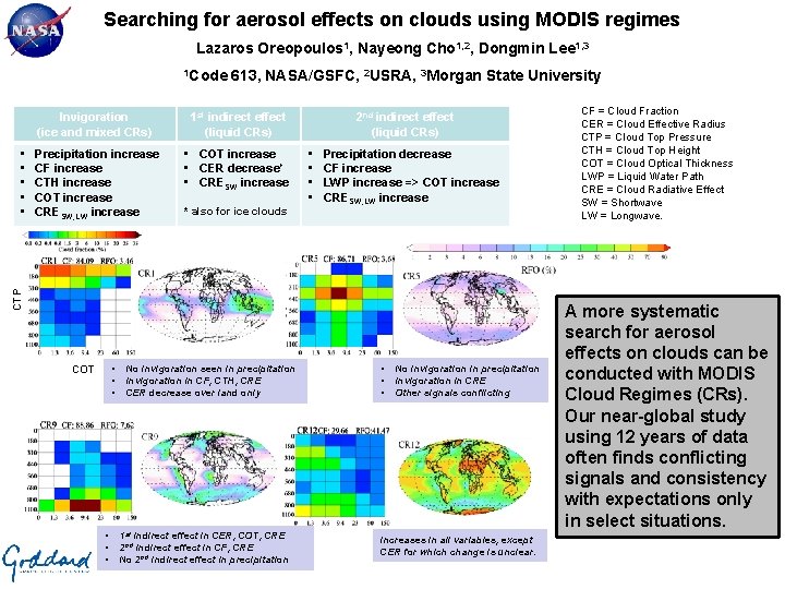
Searching for aerosol effects on clouds using MODIS regimes Lazaros Oreopoulos 1, Nayeong Cho 1, 2, Dongmin Lee 1, 3 1 Code 613, NASA/GSFC, 2 USRA, 3 Morgan State University Image taken by DSCOVR’s EPIC camera Invigoration 1 st indirect effect on March 17, 2016 at 9: 46 UTC (ice and mixed CRs) (liquid CRs) Precipitation increase CF increase CTH increase COT increase CRESW, LW increase • COT increase • CER decrease* • CRESW increase * also for ice clouds • • Precipitation decrease CF increase LWP increase => COT increase CRESW, LW increase CTP • • • 2 nd indirect effect (liquid CRs) • • • COT • • • No invigoration seen in precipitation Invigoration in CF, CTH, CRE CER decrease over land only 1 st indirect effect in CER, COT, CRE 2 nd indirect effect in CF, CRE No 2 nd indirect effect in precipitation • • • No invigoration in precipitation Invigoration in CRE Other signals conflicting Increases in all variables, except CER for which change is unclear. CF = Cloud Fraction CER = Cloud Effective Radius CTP = Cloud Top Pressure CTH = Cloud Top Height COT = Cloud Optical Thickness LWP = Liquid Water Path CRE = Cloud Radiative Effect SW = Shortwave LW = Longwave. A more systematic search for aerosol effects on clouds can be conducted with MODIS Cloud Regimes (CRs). Our near-global study using 12 years of data often finds conflicting signals and consistency with expectations only in select situations.
Name: Lazaros Oreopoulos, NASA/GSFC, Code 613 E-mail: Lazaros. Oreopoulos@nasa. gov Phone: 301 -614 -6128 References: Oreopoulos, L. , N. Cho, and D. Lee (2017), Using MODIS cloud regimes to sort diagnostic signals of aerosol-cloud-precipitation interactions, J. Geophys. Res. Atmos. , 122, 5416– 5440, doi: 10. 1002/2016 JD 026120. Data Sources: Cloud Regime data made available upon request. Other data come from the following sources: MODIS : https: //ladsweb. nascom. nasa. gov; Cloud. Sat/CALIPSO: http: //www. cloudsat. cira. colostate. edu; CERES: https: //eosweb. larc. nasa. gov/project/ceres_table; and MERRA-2: http: //disc. sci. gsfc. nasa. gov/mdisc/ Technical Description of Tables and Figure Table: Classical paradigms of aerosol-cloud-precipitation interaction and expected changes in cloud-affected quantities. We do not consider liquid water path (increase) as a criterion for 2 nd indirect effect occurrence because it is not retrieved independently from MODIS. CF=Cloud Fraction; CER=Cloud Effective Radius; CTP=Cloud Top Pressure; CTH=Cloud Top Height; COT=Cloud Optical Thickness; LWP=Liquid Water Path; CRE=Cloud Radiative Effect; SW=Shortwave; LW=Longwave. Graph: Mean joint CTP-COT histograms (centroids) representing select MODIS CRs (left panels) and their geographical frequency of occurrence (right panels). Above each centroid panel we provide the CR’s mean CF (sum of individual histogram bin CFs) and global Relative Frequency of Occurrence (RFO). Each of these CRs are meant to be representative of the CR categories in the table. CR 1: Mostly ice CR; CR 5: Mixed phase CR (both liquid and ice); CR 9: Mostly liquid CR; CR 12: Mixed phase CR. The CRs were derived by applying k-means clustering on 12 years of Terra and Aqua daily (daytime) joint histograms of CTP-COT within one-degree grid cells. Below each CR we summarize the findings for the class of CRs it belongs to. The results examined to draw the conclusions in the purple boxes are available in Oreopoulos et al. (2017) (citation above). In short, graphs were created showing how the various quantities of interest vary on average with relative (percentile) MODIS “Dark Target” AOD for each CR. Our choice of relative AOD is important because we consider the change in CR properties as the aerosol changes compared to its local seasonal climatology. Separate analysis was performed over ocean and land the results were often inconsistent. A similar analysis was also performed using MERRA-2 AOD, with results summarized in our paper. Scientific significance, societal relevance, and relationships to future missions: Since clouds greatly modify the Earth’s radiation budget and since aerosols can potentially greatly modify clouds, exploring appropriate ways to study how aerosol variability within the current climate impacts clouds is a scientific investigation of significant societal relevance. This study shows that a global study about diagnosing apparent aerosol effects on cloud is possible as long as there is a systematic way to organize the cloud observations. At the same time, the study exposes the limitations of present measurements that offer the widest coverage (passive observations): First, aerosol detection and retrieval near clouds is challenging and may yield biased results. Second, the temporal evolution of clouds and cloud-affected quantities within a changing aerosol environment cannot be monitored given the instantaneous nature of the observations (essentially one morning and one afternoon snapshot are available to us). Our results then do not show cloud is modified as aerosol varies, but rather compares similar clouds in different aerosol conditions. Future missions should therefore have better temporal coverage and be equipped with the optimal blend of passive and active instruments that will allow better detection of aerosols near clouds without sacrificing spatial coverage. Earth Sciences Division - Atmospheres
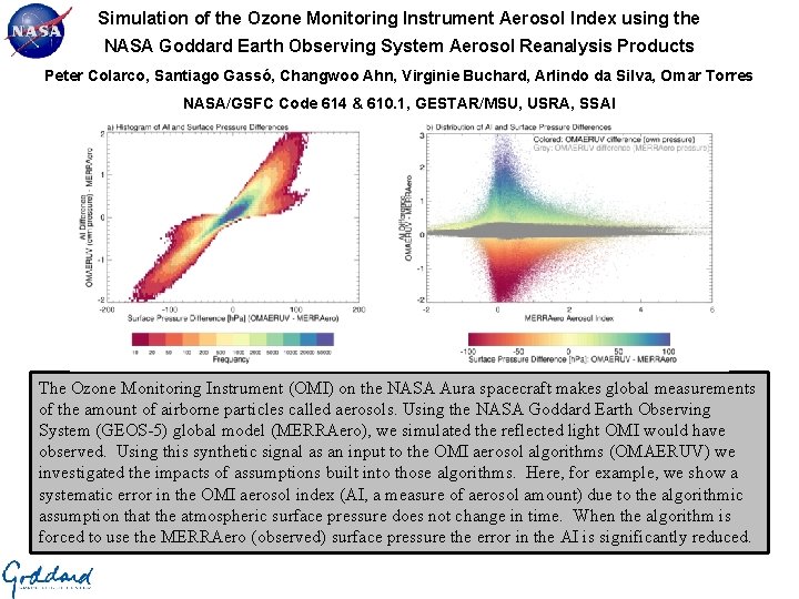
Simulation of the Ozone Monitoring Instrument Aerosol Index using the NASA Goddard Earth Observing System Aerosol Reanalysis Products Peter Colarco, Santiago Gassó, Changwoo Ahn, Virginie Buchard, Arlindo da Silva, Omar Torres NASA/GSFC Code 614 & 610. 1, GESTAR/MSU, USRA, SSAI The Ozone Monitoring Instrument (OMI) on the NASA Aura spacecraft makes global measurements of the amount of airborne particles called aerosols. Using the NASA Goddard Earth Observing System (GEOS-5) global model (MERRAero), we simulated the reflected light OMI would have observed. Using this synthetic signal as an input to the OMI aerosol algorithms (OMAERUV) we investigated the impacts of assumptions built into those algorithms. Here, for example, we show a systematic error in the OMI aerosol index (AI, a measure of aerosol amount) due to the algorithmic assumption that the atmospheric surface pressure does not change in time. When the algorithm is forced to use the MERRAero (observed) surface pressure the error in the AI is significantly reduced.
Name: Peter Colarco, NASA/GSFC, Code 614 E-mail: peter. r. colarco@nasa. gov Phone: 301 -614 -6382 References: Colarco, P. R. , Gassó, S. , Ahn, C. , Buchard, V. , da Silva, A. M. and Torres, O. : Simulation of the Ozone Monitoring Instrument Aerosol Index using the NASA Goddard Earth Observing System Aerosol Reanalysis Products, Atmospheric Measurement Techniques - Discussions. , 1– 22, doi: 10. 5194/amt-2017 -87, 2017. Data Sources: Level 2 NASA Aura Ozone Monitoring Instrument (OMI) aerosol products, including aerosol index, viewing geometry, and surface albedo. Also used were results from the Goddard Earth Observing System (GEOS-5) global atmospheric model. The specific GEOS-5 simulating was based on the MERRAero aerosol reanalysis, which included assimilation of aerosol optical depth derived from the Moderate Resolution Imaging Spectroradiometer (MODIS) instruments that are flying on the NASA Terra and Aqua spacecraft. Technical Description of Figures: Graphic 1 (left): Shown in a joint-PDF histogram of the difference in the OMI aerosol index directly computed from the GEOS-5 model results (MERRAero) versus the aerosol index returned by the OMI aerosol algorithms (OMAERUV) (left axis) as a function of the difference between the surface pressure from MERRAero (based on actual, observed meteorology) and assumption of a time invariant surface pressure used in the OMAERUV algorithms (bottom axis). The color indicates the frequency of occurrence of these differences for the month of June 2007, reflecting the millions of pixels compared. The result shows that where OMI assumes a higher surface pressure than was actually present there is a tendency for it to also return a higher aerosol index, indicating an overestimate of the aerosol loading. Graphic 2 (right): Essentially the same data is presented here, but now sorted to show the error in the aerosol index (left axis) is related to the real aerosol index (as simulated by MERRAero, bottom axis). Individual pixels are colored by the surface pressure error described above. The error in the aerosol index is here seen to be also a function of the absolute aerosol index, where higher aerosol index (indicating more aerosol loading) leads to smaller overall error caused by the surface pressure error (i. e. , high aerosol loading overcomes the algorithmic assumptions on surface pressure). Scientific significance, societal relevance, and relationships to future missions: The use of a global aerosol model to simulate the satellite observed signal provides a powerful tool for designing new missions and testing algorithms. In this particular study we investigated two aspects of the OMI aerosol algorithms, particularly the surface pressure assumption illustrated in the slide and then the assumptions made in how the algorithm handles its radiative transfer calculation. This study suggests two concrete recommendations to improve the aerosol products from OMI: (1) using actual surface pressures from meteorological analyses in deriving their products and (2) using a higher resolution lookup table of precomputed radiative properties of the atmosphere in generating products. Both of these improvements will in the future improve the quality of the aerosol products. This same kind of tool has been applied observations from the MODIS instrument, among others, and forms the basis for a number of efforts using the GEOS-5 model to inform design and algorithm strategies for future Earth science space missions. Earth Sciences Division - Atmospheres
- Slides: 6