A CONSENSUS APPROACH TO OPERATIONALLY ESTIMATE AND FORECAST

- Slides: 42

A CONSENSUS APPROACH TO OPERATIONALLY ESTIMATE AND FORECAST TROPICAL CYCLONE WIND RADII John Knaff (John. Knaff@noaa. gov) NOAA Center for Satellite Applications and Research, Fort Collins, CO Buck Sampson – Naval Research Laboratory, Monterey, CA Brian Strahl – Joint Typhoon Warning Center, Pearl Harbor, HI

11/15/2016 A special thanks to: International Workshop on High Winds Over the Ocean The European Space Agency for providing travel funding (airfare + accommodations) Outline What are tropical cyclone wind radii? Why we should care? Facts about how they are created An objective method to estimate tropical cyclone wind radii at t = 0 Why getting good initial estimates is important? A method to improve forecasts of wind radii, particularly gale-force winds 2

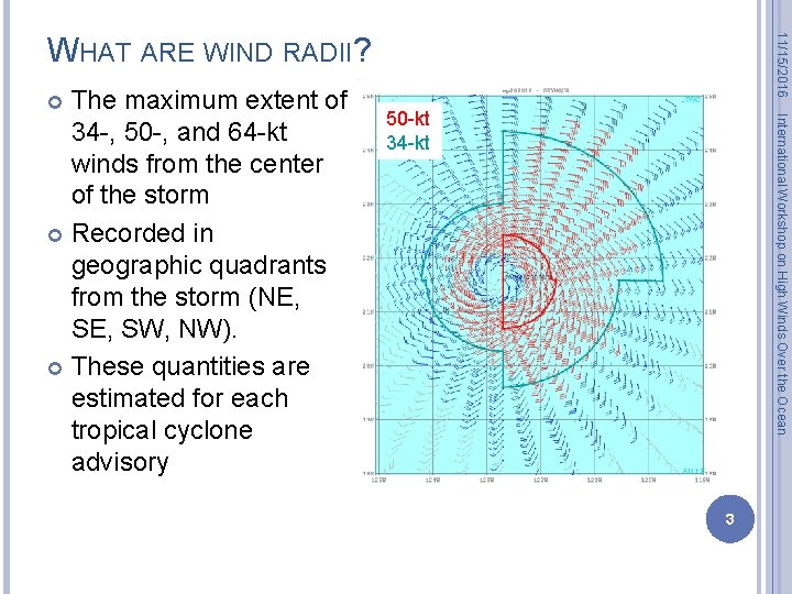
50 -kt 34 -kt International Workshop on High Winds Over the Ocean The maximum extent of 34 -, 50 -, and 64 -kt winds from the center of the storm Recorded in geographic quadrants from the storm (NE, SW, NW). These quantities are estimated for each tropical cyclone advisory 11/15/2016 WHAT ARE WIND RADII? 3

11/15/2016 OPERATIONAL WIND RADII: WHY DO WE CARE? International Workshop on High Winds Over the Ocean Wind radii are the only operational estimate of the surface wind structure � Are provided to NWP via TC vitals � Are input to the wind speed probability product They are the basis for values in the best tracks and all the validation that uses them They are important in determining the size/length of watches, warnings, and MSLPs They are important for determining waves, wave setup and storm surge 4

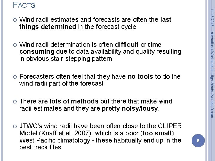
Wind radii estimates and forecasts are often the last things determined in the forecast cycle Wind radii determination is often difficult or time consuming due to data availability and quality resulting in obvious stair-stepping pattern Forecasters often feel that they have no tools to do the wind radii part of the forecast There are lots of methods out there that make wind radii estimates and they are pretty noisy/lousy. JTWC’s wind radii have been often close to the CLIPER Model (Knaff et al. 2007), which is a poor (too small) West Pacific climatology - these habitually end up in the best track files International Workshop on High Winds Over the Ocean 11/15/2016 FACTS 5

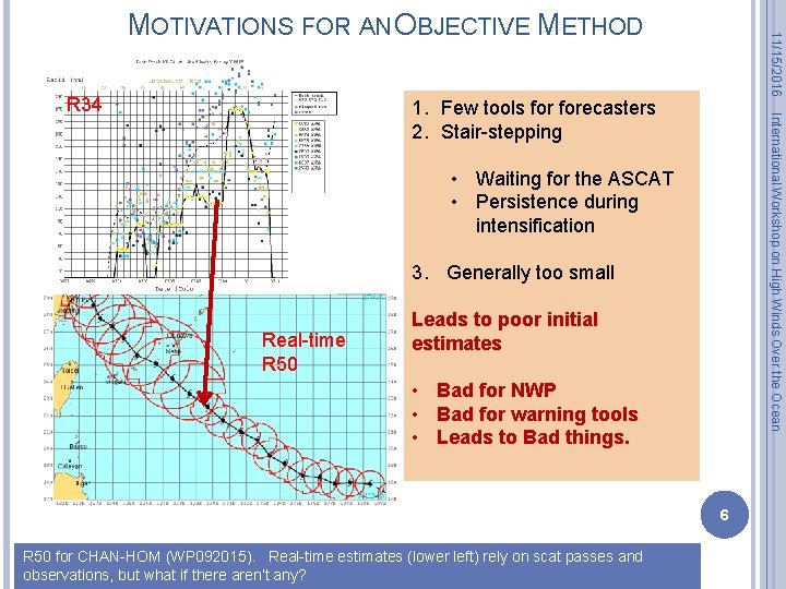
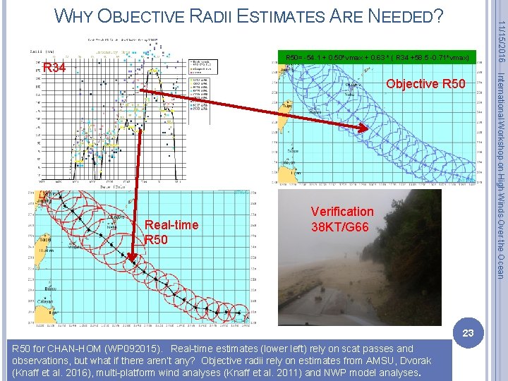
R 34 11/15/2016 MOTIVATIONS FOR AN OBJECTIVE METHOD International Workshop on High Winds Over the Ocean 1. Few tools forecasters 2. Stair-stepping • Waiting for the ASCAT • Persistence during intensification 3. Generally too small Real-time R 50 Leads to poor initial estimates • Bad for NWP • Bad for warning tools • Leads to Bad things. 6 R 50 for CHAN-HOM (WP 092015). Real-time estimates (lower left) rely on scat passes and observations, but what if there aren’t any?

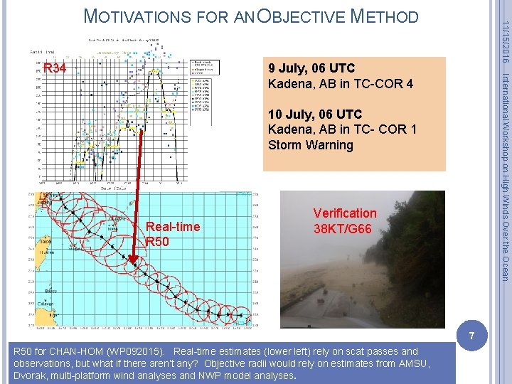
R 34 11/15/2016 MOTIVATIONS FOR AN OBJECTIVE METHOD International Workshop on High Winds Over the Ocean 9 July, 06 UTC Kadena, AB in TC-COR 4 10 July, 06 UTC Kadena, AB in TC- COR 1 Storm Warning Real-time R 50 Verification 38 KT/G 66 7 R 50 for CHAN-HOM (WP 092015). Real-time estimates (lower left) rely on scat passes and observations, but what if there aren’t any? Objective radii would rely on estimates from AMSU, Dvorak, multi-platform wind analyses and NWP model analyses.

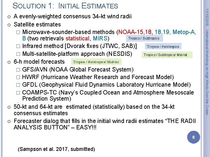
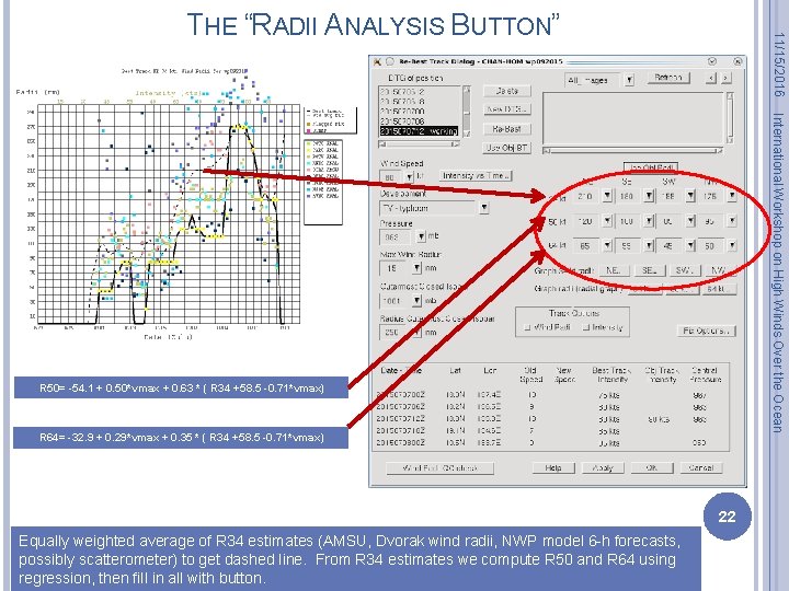
8 (Sampson et al. 2017, submitted) International Workshop on High Winds Over the Ocean A evenly-weighted consensus 34 -kt wind radii Satellite estimates � Microwave-sounder-based methods (NOAA-15, 18, 19, Metop-A, Tropics / Subtropics B (two retrievals statistical, MIRS) � Infrared method [Dvorak fixes (JTWC, SAB)] � Multi-satellite-platform approach (NESDIS) Tropics / Subtropics/ Mid-lat 6 -h model forecasts � GFS/AVN (NOAA Global Forecast System) � HWRF (Hurricane Weather Research and Forecast Model) � GFDL (Geophysical Fluid Dynamics Laboratory Hurricane Model) � COAMPS-TC (Navy’s Coupled Ocean and Atmosphere Mesoscale Prediction System) 50 -kt and 64 -kt are estimated (statistically) based on the 34 -kt consensus estimates Forecaster dialog that fills in the initial wind radii estimates “THE RADII ANALYSIS BUTTON” – EASY!!! 11/15/2016 SOLUTION 1: INITIAL ESTIMATES

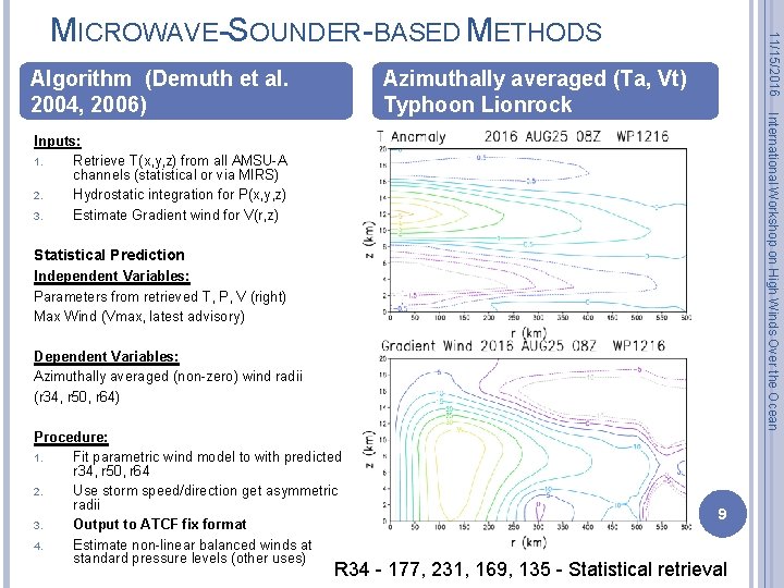
Azimuthally averaged (Ta, Vt) Typhoon Lionrock International Workshop on High Winds Over the Ocean Algorithm (Demuth et al. 2004, 2006) 11/15/2016 MICROWAVE-SOUNDER-BASED METHODS Inputs: 1. Retrieve T(x, y, z) from all AMSU-A channels (statistical or via MIRS) 2. Hydrostatic integration for P(x, y, z) 3. Estimate Gradient wind for V(r, z) Statistical Prediction Independent Variables: Parameters from retrieved T, P, V (right) Max Wind (Vmax, latest advisory) Dependent Variables: Azimuthally averaged (non-zero) wind radii (r 34, r 50, r 64) Procedure: 1. Fit parametric wind model to with predicted r 34, r 50, r 64 2. Use storm speed/direction get asymmetric radii 3. Output to ATCF fix format 4. Estimate non-linear balanced winds at standard pressure levels (other uses) 9 R 34 - 177, 231, 169, 135 - Statistical retrieval

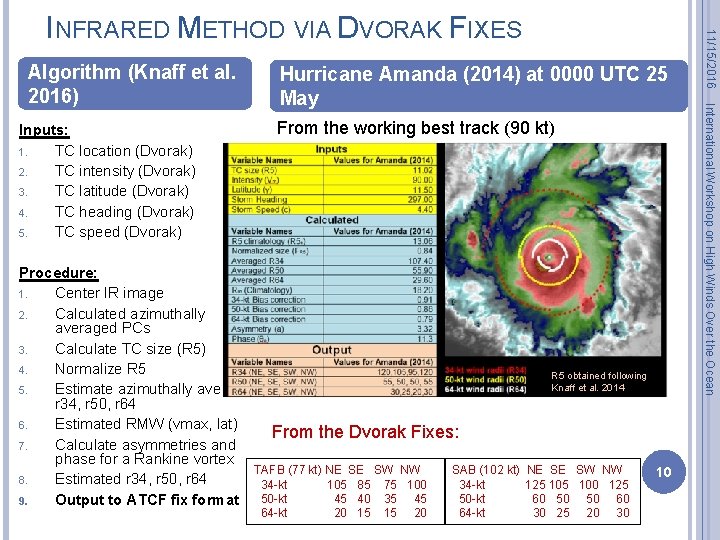
Inputs: 1. TC location (Dvorak) 2. TC intensity (Dvorak) 3. TC latitude (Dvorak) 4. TC heading (Dvorak) 5. TC speed (Dvorak) Hurricane Amanda (2014) at 0000 UTC 25 May From the working best track (90 kt) Procedure: 1. Center IR image 2. Calculated azimuthally averaged PCs 3. Calculate TC size (R 5) 4. Normalize R 5 5. Estimate azimuthally average r 34, r 50, r 64 6. Estimated RMW (vmax, lat) From the Dvorak Fixes: 7. Calculate asymmetries and phase for a Rankine vortex TAFB (77 kt) NE SE SW NW SAB (102 kt) 8. Estimated r 34, r 50, r 64 34 -kt 105 85 75 100 34 -kt 50 -kt 45 40 35 45 50 -kt 9. Output to ATCF fix format 64 -kt 20 15 15 20 64 -kt R 5 obtained following Knaff et al. 2014 NE SE SW NW 125 100 125 60 50 50 60 30 25 20 30 10 International Workshop on High Winds Over the Ocean Algorithm (Knaff et al. 2016) 11/15/2016 INFRARED METHOD VIA DVORAK FIXES

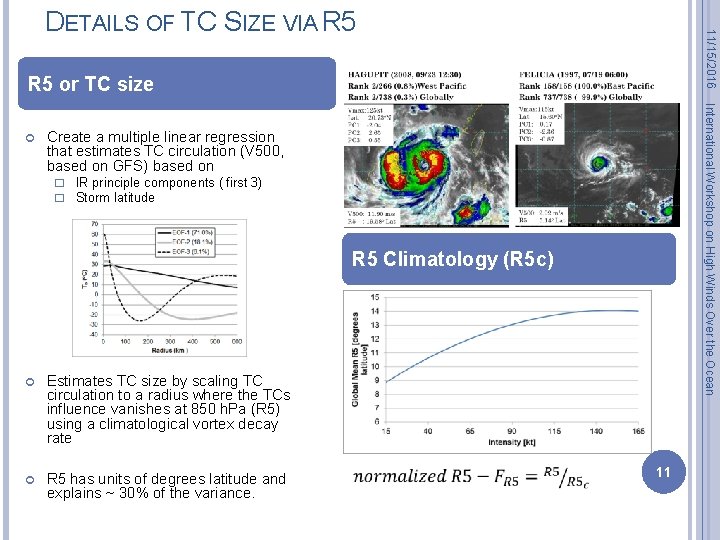
11/15/2016 DETAILS OF TC SIZE VIA R 5 or TC size International Workshop on High Winds Over the Ocean Create a multiple linear regression that estimates TC circulation (V 500, based on GFS) based on � IR principle components ( first 3) � Storm latitude R 5 Climatology (R 5 c) Estimates TC size by scaling TC circulation to a radius where the TCs influence vanishes at 850 h. Pa (R 5) using a climatological vortex decay rate R 5 has units of degrees latitude and explains ~ 30% of the variance. 11

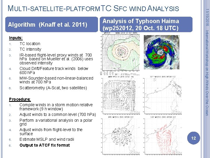
Algorithm (Knaff et al. 2011) 11/15/2016 MULTI-SATELLITE-PLATFORM TC SFC WIND ANALYSIS International Workshop on High Winds Over the Ocean Analysis of Typhoon Haima (wp 252012, 20 Oct. 18 UTC) Inputs: 1. TC location 2. TC intensity 3. IR-based flight-level proxy winds at 700 h. Pa based on Mueller et al. (2006) uses observed intensity 4. Cloud Drift/Feature track winds below 600 h. Pa 5. MW-Sounder-based non-linear-balanced winds at 700 h. Pa 6. Scatterometry (A-Scat, two satellites) Procedure: 1. Compile winds in a storm motion relative framework (9 h window) 2. Adjust winds to a common level (700 h. Pa) 3. Perform a variational analysis on a polar grid 4. Adjust winds from flight-level to the surface 5. Estimate MSLP and wind radii 6. Output to ATCF fix format 12

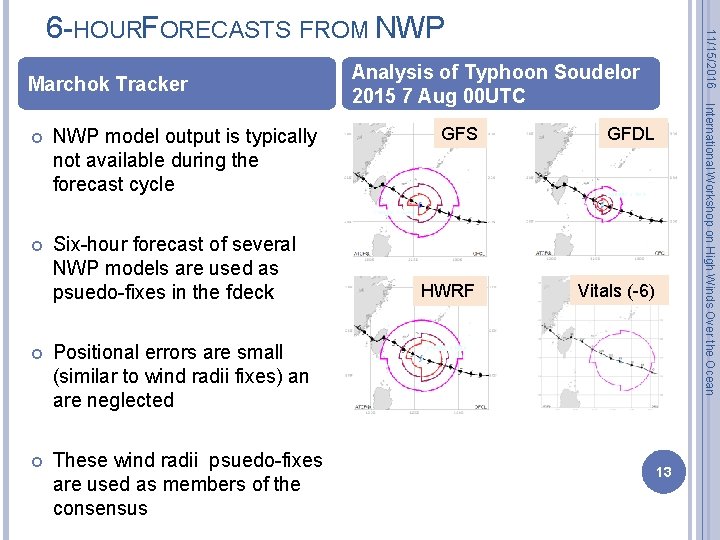
Marchok Tracker NWP model output is typically not available during the forecast cycle Six-hour forecast of several NWP models are used as psuedo-fixes in the fdeck Positional errors are small (similar to wind radii fixes) an are neglected These wind radii psuedo-fixes are used as members of the consensus Analysis of Typhoon Soudelor 2015 7 Aug 00 UTC GFS GFDL HWRF Vitals (-6) International Workshop on High Winds Over the Ocean 11/15/2016 6 -HOURFORECASTS FROM NWP 13

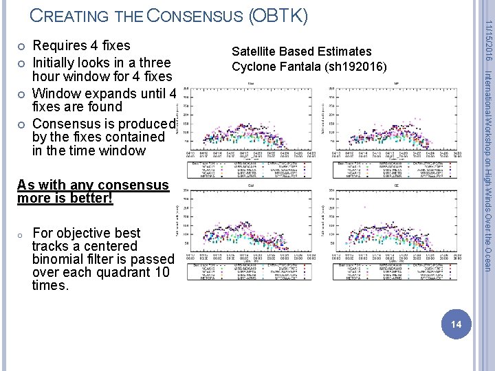
Satellite Based Estimates Cyclone Fantala (sh 192016) International Workshop on High Winds Over the Ocean Requires 4 fixes Initially looks in a three hour window for 4 fixes Window expands until 4 fixes are found Consensus is produced by the fixes contained in the time window 11/15/2016 CREATING THE CONSENSUS (OBTK) As with any consensus more is better! o For objective best tracks a centered binomial filter is passed over each quadrant 10 times. 14

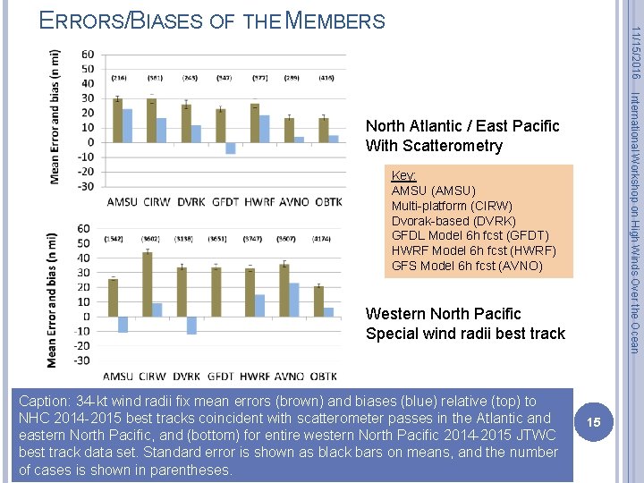
11/15/2016 ERRORS/BIASES OF THE MEMBERS International Workshop on High Winds Over the Ocean North Atlantic / East Pacific With Scatterometry Key: AMSU (AMSU) Multi-platform (CIRW) Dvorak-based (DVRK) GFDL Model 6 h fcst (GFDT) HWRF Model 6 h fcst (HWRF) GFS Model 6 h fcst (AVNO) Western North Pacific Special wind radii best track Caption: 34 -kt wind radii fix mean errors (brown) and biases (blue) relative (top) to NHC 2014 -2015 best tracks coincident with scatterometer passes in the Atlantic and eastern North Pacific, and (bottom) for entire western North Pacific 2014 -2015 JTWC best track data set. Standard error is shown as black bars on means, and the number of cases is shown in parentheses. 15

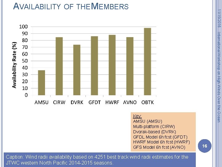
11/15/2016 AVAILABILITY OF THE MEMBERS Caption: Wind radii availability based on 4251 best track wind radii estimates for the JTWC western North Pacific 2014 -2015 seasons. International Workshop on High Winds Over the Ocean Key: AMSU (AMSU) Multi-platform (CIRW) Dvorak-based (DVRK) GFDL Model 6 h fcst (GFDT) HWRF Model 6 h fcst (HWRF) GFS Model 6 h fcst (AVNO) 16

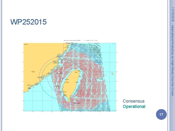
11/15/2016 International Workshop on High Winds Over the Ocean WP 252015 Consensus Operational 17

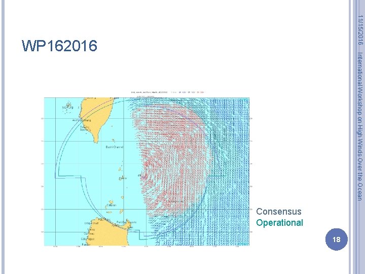
11/15/2016 International Workshop on High Winds Over the Ocean WP 162016 Consensus Operational 18

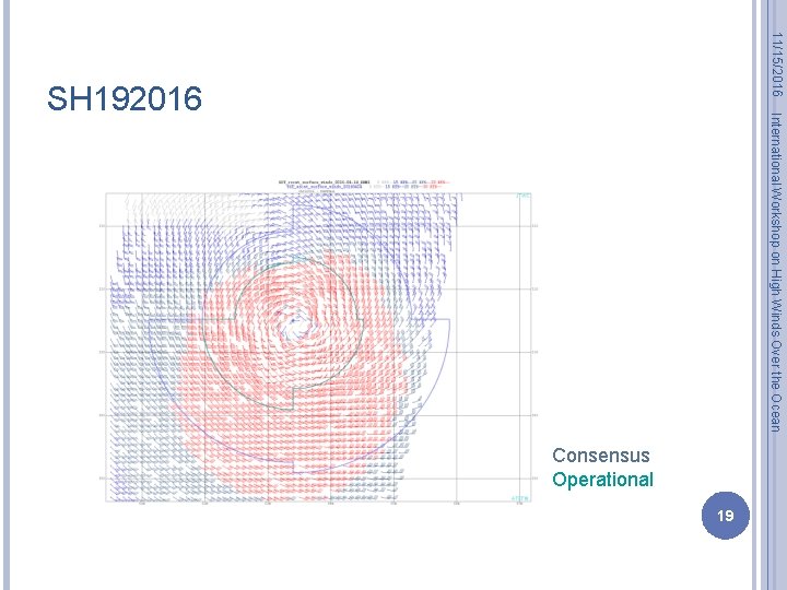
11/15/2016 International Workshop on High Winds Over the Ocean SH 192016 Consensus Operational 19

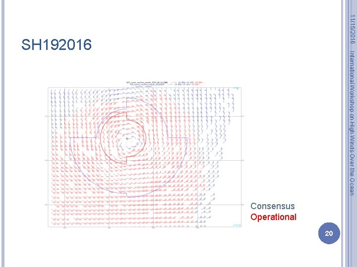
11/15/2016 International Workshop on High Winds Over the Ocean SH 192016 Consensus Operational 20

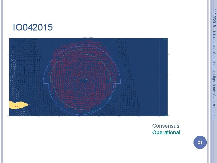
11/15/2016 International Workshop on High Winds Over the Ocean IO 042015 Consensus Operational 21

11/15/2016 THE “RADII ANALYSIS BUTTON” International Workshop on High Winds Over the Ocean R 50= -54. 1 + 0. 50*vmax + 0. 63 * ( R 34 +58. 5 -0. 71*vmax) R 64= -32. 9 + 0. 29*vmax + 0. 35 * ( R 34 +58. 5 -0. 71*vmax) 22 Equally weighted average of R 34 estimates (AMSU, Dvorak wind radii, NWP model 6 -h forecasts, possibly scatterometer) to get dashed line. From R 34 estimates we compute R 50 and R 64 using regression, then fill in all with button.

R 50= -54. 1 + 0. 50*vmax + 0. 63 * ( R 34 +58. 5 -0. 71*vmax) Objective R 50 Real-time R 50 Verification 38 KT/G 66 23 R 50 for CHAN-HOM (WP 092015). Real-time estimates (lower left) rely on scat passes and observations, but what if there aren’t any? Objective radii rely on estimates from AMSU, Dvorak (Knaff et al. 2016), multi-platform wind analyses (Knaff et al. 2011) and NWP model analyses. International Workshop on High Winds Over the Ocean R 34 11/15/2016 WHY OBJECTIVE RADII ESTIMATES ARE NEEDED?

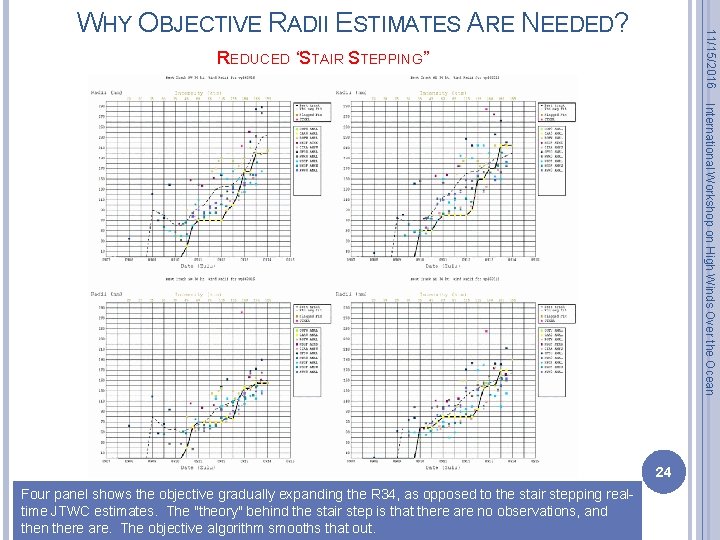
11/15/2016 WHY OBJECTIVE RADII ESTIMATES ARE NEEDED? REDUCED “STAIR STEPPING” International Workshop on High Winds Over the Ocean 24 Four panel shows the objective gradually expanding the R 34, as opposed to the stair stepping realtime JTWC estimates. The "theory" behind the stair step is that there are no observations, and then there are. The objective algorithm smooths that out.

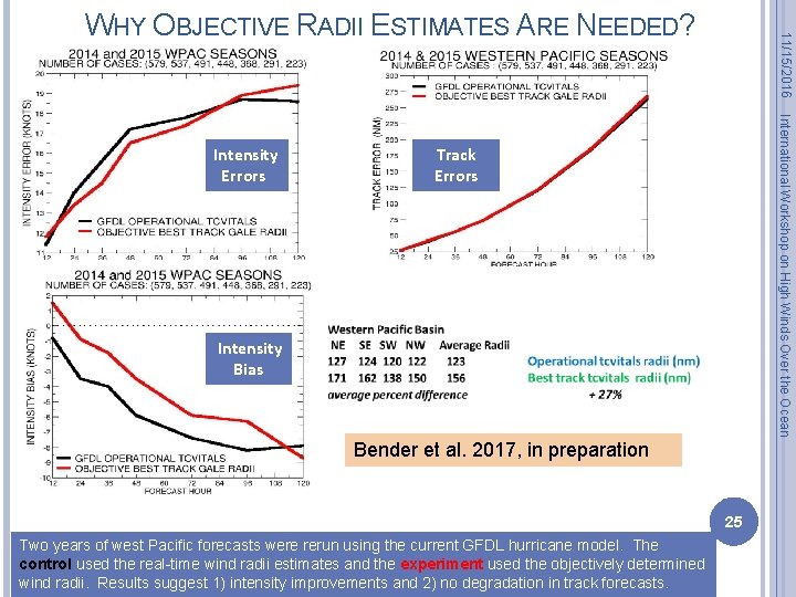
International Workshop on High Winds Over the Ocean Intensity Errors 11/15/2016 WHY OBJECTIVE RADII ESTIMATES ARE NEEDED? Track Errors Intensity Bias Bender et al. 2017, in preparation 25 Two years of west Pacific forecasts were rerun using the current GFDL hurricane model. The control used the real-time wind radii estimates and the experiment used the objectively determined wind radii. Results suggest 1) intensity improvements and 2) no degradation in track forecasts.

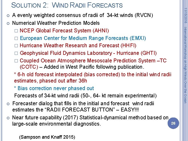
(Sampson and Knaff 2015) International Workshop on High Winds Over the Ocean A evenly weighted consensus of radii of 34 -kt winds (RVCN) Numerical Weather Prediction Models � NCEP Global Forecast System (AHNI) � European Center for Medium Range Forecasts (EMXI) � Hurricane Weather Research and Forecast (HHFI) � Geophysical Fluid Dynamics Laboratory - Hurricane (GHTI) � Coupled Ocean Atmosphere Mesoscale Prediction System –TC (COTC) – Added in West Pacific following publication. * 6 -h old forecast interpolated (bias corrected) to the initial wind radii estimates, phased out after 36 h * Bias correction never phased out Forecasts of 34 -kt wind radii (50 -, 64 - kt remain experimental) Forecaster dialog that fills in the initial and forecast wind radii estimates the “RADII FORECAST BUTTON” – EASY!!! Near future capability (2017) Statistical-dynamical method based on 26 large-scale environmental diagnostics. 11/15/2016 SOLUTION 2: WIND RADII FORECASTS

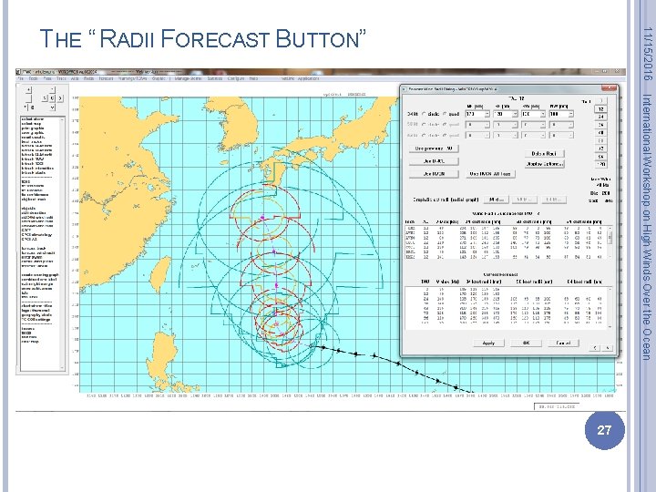
11/15/2016 THE “ RADII FORECAST BUTTON” International Workshop on High Winds Over the Ocean 27

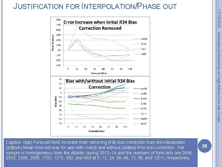
11/15/2016 JUSTIFICATION FOR INTERPOLATION/PHASE OUT International Workshop on High Winds Over the Ocean Caption: (top) Forecast MAE increase from removing R 34 bias correction from the interpolator. (bottom) Mean forecast bias for aids with (solid) and without (dotted) R 34 bias correction. The sample is homogeneous from the Atlantic during 2012– 14 and the numbers of forecasts are 2696, 2532, 2268, 2008, 1732, 1272, 932, and 668 at 0, 12, 24, 36, 48, 72, 96, and 120 h, respectively. 28

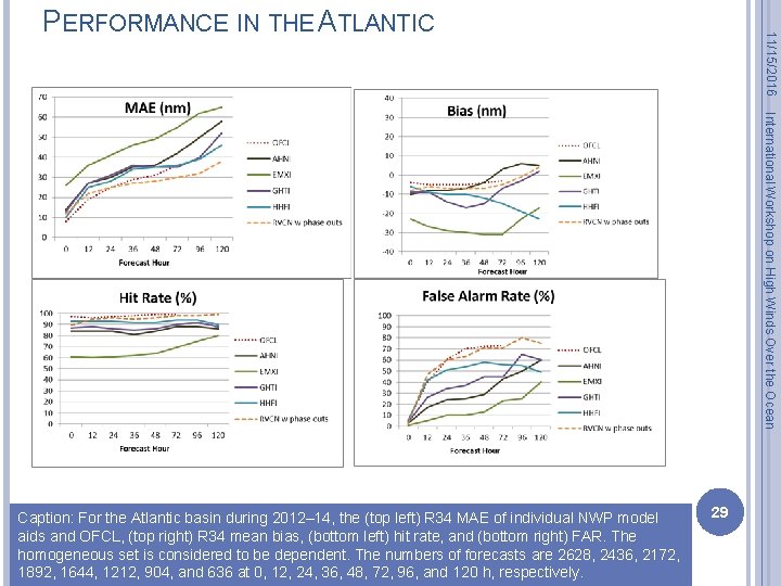
11/15/2016 PERFORMANCE IN THE ATLANTIC International Workshop on High Winds Over the Ocean Caption: For the Atlantic basin during 2012– 14, the (top left) R 34 MAE of individual NWP model aids and OFCL, (top right) R 34 mean bias, (bottom left) hit rate, and (bottom right) FAR. The homogeneous set is considered to be dependent. The numbers of forecasts are 2628, 2436, 2172, 1892, 1644, 1212, 904, and 636 at 0, 12, 24, 36, 48, 72, 96, and 120 h, respectively. 29

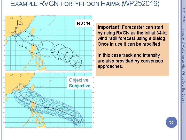
EXAMPLE RVCN FORTYPHOON HAIMA (WP 252016) 11/15/2016 RVCN International Workshop on High Winds Over the Ocean Important: Forecaster can start by using RVCN as the initial 34 -kt wind radii forecast using a dialog. Once in use it can be modified In this case track and intensity are also provided by consensus approaches. Objective Subjective 30

A consensus method has been developed to estimate initial wind radii for the operational forecaster This method makes use of satellite-based and modelforecast-based 34 -knot wind radii. 50 - and 64 - knot winds are estimated via statistical relationships with 34 -knot wind radii The method 1) has been automated, 2) compares well with NHC best tracks and A-SCAT observations, 3) provides a wind radii estimate tool for JTWC forecasters, and 4) saves forecasters time The method results in a consistent and stable estimate that is more ideally suited for model initialization This capability should result in dramatic improvements of JTWC’s wind radii estimates More quality techniques/fix types will only improve wind radii estimates using this technique (ideas from this workshop? ) International Workshop on High Winds Over the Ocean 11/15/2016 SUMMARY (SOLUTION #1, INITIAL WIND RADII) 31

A consensus method has been used to forecast wind radii, 34 -kt winds, for the operational JTWC forecaster This method makes use of existing model-forecast guidance 34 -knot wind radii The six-hour old forecast is interpolated (bias corrected) for most models, with the bias correction phasing out after 36 h. The method 1) has been automated 2) compares well with NHC best tracks, and NHC forecasts 3) provides a wind radii estimate tool for JTWC forecasters, and 4) saves forecasters time This capability should result in dramatic improvements of JTWC’s wind radii forecasts and has led to JTWC now issuing 34 -kt wind radii forecasts through 120 h More quality forecast techniques/models will only improve this technique International Workshop on High Winds Over the Ocean 11/15/2016 SUMMARY (SOLUTION #2, FORECASTING WIND RADII) 32

I’m interested in new methods to estimate and predict TC structure, especially the surface winds I would very much like to collaborate on these topics: International Workshop on High Winds Over the Ocean 11/15/2016 THANK ESA FOR GETTING ME HERE! � Surface wind fields without aircraft reconnaisance � Estimating the radius of maximum winds without aircraft � What processes lead to growth during intensification or growth during steady or slowly weakening storms Check out http: //rammb. cira. colostate. edu/products/tc_realtime/index. asp 33

11/15/2016 International Workshop on High Winds Over the Ocean EXTRA SLIDES 34

11/15/2016 REFERENCES USED: Demuth, J. L. , M. De. Maria, J. A. Knaff, and T. H. Vonder Haar, 2004: Evaluation of advanced microwave sounder unit (AMSU) tropical cyclone intensity and size estimation algorithm, J. App. Met. , 43, 282 -296. International Workshop on High Winds Over the Ocean Demuth, J. , M. De. Maria, and J. A. Knaff, 2006: Improvement of Advanced Microwave Sounding Unit Tropical Cyclone Intensity and Size Estimation Algorithms, Journal of Applied Meteorology and Climatology, 45(11), 1573– 1581. Mueller, K. J. , M. De. Maria, J. A. Knaff, J. P. Kossin, T. H. Vonder Haar: , 2006: Objective Estimation of Tropical Cyclone Wind Structure from Infrared Satellite Data. Wea Forecasting, 21(6), 990– 1005. Knaff, J. A. , C. R. Sampson, M. De. Maria, T. P. Marchok, J. M. Gross, and C. J. Mc. Adie, 2007: Statistical Tropical Cyclone Wind Radii Prediction Using Climatology and Persistence, Wea. Forecasting, 22(4), 781– 791. Boukabara, S. A. and Co-authors 2011: Mi. RS: An All-Weather 1 DVAR Satellite Data Assimilation and Retrieval System. IEEE Transactions on Geoscience and Remote Sensing, vol. 49, no. 9, pp. 3249 -3272. Knaff, J. A. , M. De. Maria, D. A. Molenar, C. R. Sampson and M. G. Seybold, 2011: An automated, objective, multisatellite platform tropical cyclone surface wind analysis. J. of Applied Meteorology and Climatology. 50(10), 21492166. Knaff, J. A. , C. J. Slocum, K. D. Musgrave, C. R. Sampson, and B. R. Strahl, 2016: Using routinely available information to estimate tropical cyclone wind structure. Mon. Wea. Rev. , 144: 4, 1233 -1247. Sampson C. R, and J. A. Knaff, 2015: A consensus forecast for tropical cyclone gale wind radii. Wea. Forecasting, 30, 1397 -1403. Sampson C. R. , E. M. Fukada, J. A. Knaff, B. R. Strahl, M. J. Brennan, and T. Marchok, 2017: Tropical cyclone gale wind radii estimates for the western North Pacific. Submitted Wea. Forecasting. 35

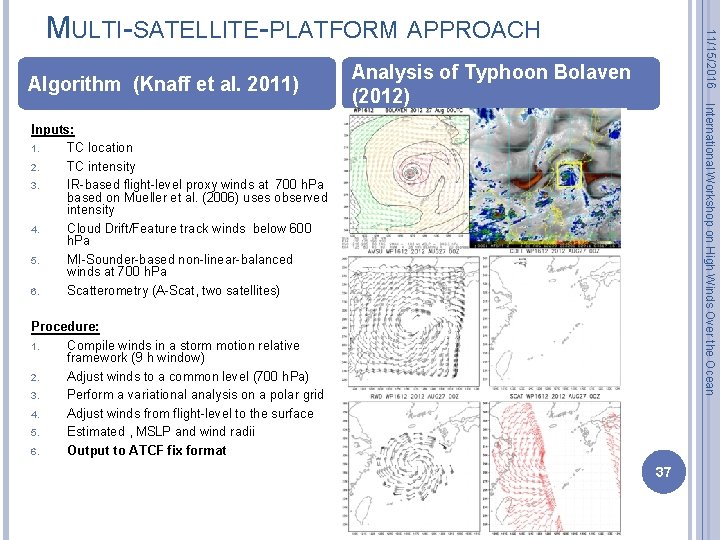
Algorithm (Knaff et al. 2011) 11/15/2016 MULTI-SATELLITE-PLATFORM APPROACH International Workshop on High Winds Over the Ocean Analysis of Typhoon Bolaven (2012) Inputs: 1. TC location 2. TC intensity 3. IR-based flight-level proxy winds at 700 h. Pa based on Mueller et al. (2006) uses observed intensity 4. Cloud Drift/Feature track winds below 600 h. Pa 5. MI-Sounder-based non-linear-balanced winds at 700 h. Pa 6. Scatterometry (A-Scat, two satellites) Procedure: 1. Compile winds in a storm motion relative framework (9 h window) 2. Adjust winds to a common level (700 h. Pa) 3. Perform a variational analysis on a polar grid 4. Adjust winds from flight-level to the surface 5. Estimated , MSLP and wind radii 6. Output to ATCF fix format 37

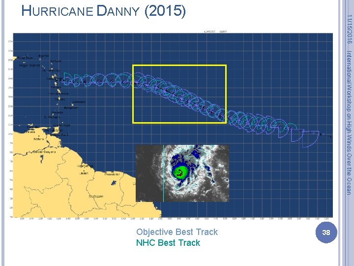
International Workshop on High Winds Over the Ocean 38 Objective Best Track NHC Best Track 11/15/2016 HURRICANE DANNY (2015)

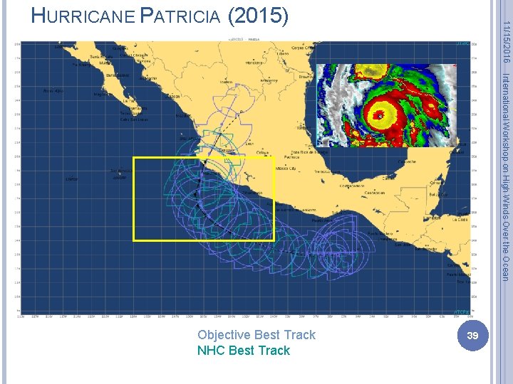
11/15/2016 HURRICANE PATRICIA (2015) International Workshop on High Winds Over the Ocean Objective Best Track NHC Best Track 39

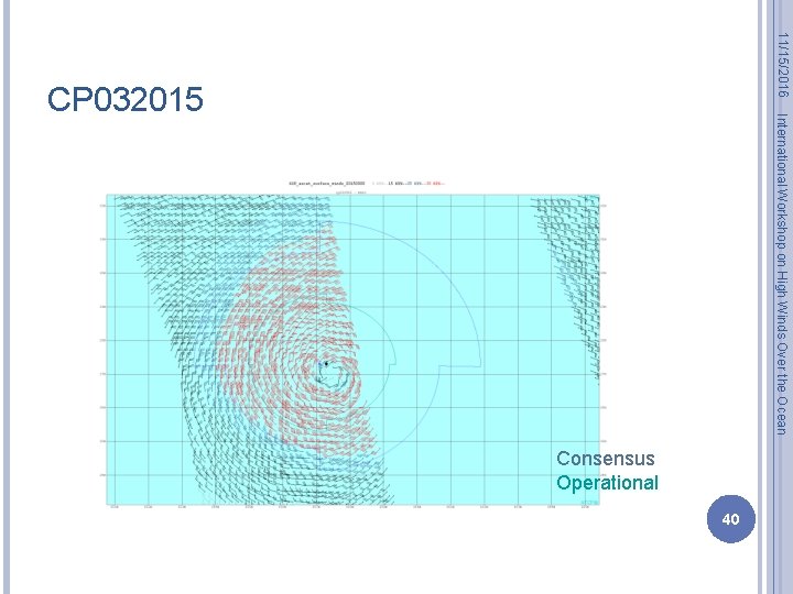
11/15/2016 International Workshop on High Winds Over the Ocean CP 032015 Consensus Operational 40

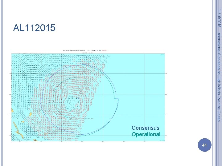
11/15/2016 International Workshop on High Winds Over the Ocean AL 112015 Consensus Operational 41

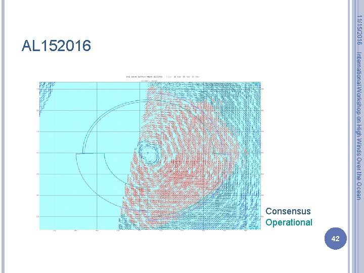
11/15/2016 International Workshop on High Winds Over the Ocean AL 152016 Consensus Operational 42

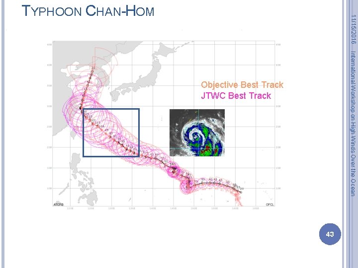
11/15/2016 TYPHOON CHAN-HOM International Workshop on High Winds Over the Ocean Objective Best Track JTWC Best Track 43