A comparison of Airborne Vector Gravimeter Measurements with

A comparison of Airborne Vector Gravimeter Measurements with the Geoid Slope Validation Survey 2014 Ferguson S 1, Wang YM 2, S. Elieff 1, X Li 3, S Holmes 4, K Ahlgren 2 and R Xi 1 Sander Geophysics Ltd. Canada National Geodetic Survey, NOAA, USA 3 DST Inc. USA 4 SGT Inc. USA 1 2 IAG-IASPEI 2017 Kobe | Japan | July 30 - August 5, 2017 1

Geoid Slope Validation Survey 2014 GSVS 14 is the second survey conducted by the NGS to test differential accuracy of the gravimetric geoid model. It was conducted in Iowa, predominantly along Highway 30, from Denison to Cedar Rapids ~ 200 miles (325 km) long, 204 survey benchmarks Medium-high, relatively flat area ranging from 740 feet to 1, 440 feet above sea level gravimetrically complex (Midcontinent Rift)

AIRGrav System Airborne Inertially Referenced Gravimetry AIRGrav designed and built specifically for airborne gravity surveying by SGL 10 years of R&D following by 16 years of survey flying, 12 gravimeters Three axis (x y z) gyro stabilized platform, three (x y z) accelerometers Dual frequency GPS receivers Gravity = inertial accelerations – GPS accelerations Raw gravity data sampled at 128 Hz

SGL Flight Information June 28, 2015 Repeat line flown West then East 600 m ellipsoidal (~ 400 m AGL at East end, ~200 m AGL at West end) 320 km long ~ 55 m/s (200 km/h) Also flown next day at 2185 m ellipsoidal, 58 m/s, West and East (results not presented here)

AIRGrav Data Processing Steps Kalman Filter combination of GPS positions and gravimeter accelerations Multiple GPS solutions used to minimize acceleration noise 3 gravity components are estimated states in the filter EGM 2008 used during processing to loosely constrain horizontal component estimates, which are corrupted by uncertainty in gyro drift 100 s (5. 5 km) full wavelength filter applied

East-West Component of Gravity Disturbance Blue = West Red = East Std dev from mean = 0. 582 m. Gal W std dev from EGM 2008 = 1. 27 m. Gal E std dev from EGM 2008 = 1. 21 m. Gal

North-South Component Gravity Disturbance Blue = West Red = East Std dev from mean = 0. 567 m. Gal W std dev from EGM 2008 = 1. 35 m. Gal E std dev from EGM 2008 = 1. 62 m. Gal

Vertical component of Gravity Disturbance Red = West Blue = East Std dev from mean = 0. 418 m. Gal W std dev from EGM 2008 = 1. 62 m. Gal E std dev from EGM 2008 = 1. 67 m. Gal
 • High")
SGL Geoid Profile Computation • Method of line-integration (Jekeli and Kwon 2002) • High resolution global gravity model EIGEN 6 c 4 was used in the remove-restore fashion • Downward continuation correction is computed from EIGEN 6 c 4 model
")
Harmonic Downward Continuation Correction to the Geoid (Eigen 6 c 4, Unit in mm)

Collocated points between the SGL flight and GSVS 14 traverse
 at the collocated points")
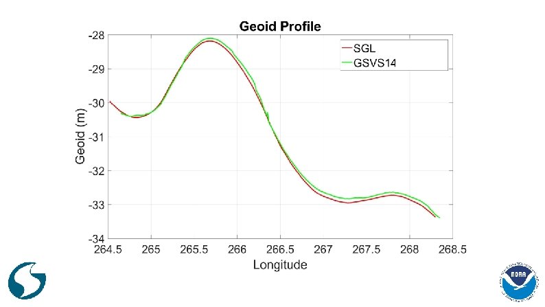
Geoid height differences (SGL flight – GSVS 14) at the collocated points
 • 3 components of the gravity disturbance observed by AIRGrav agree with")
Conclusions (1) • 3 components of the gravity disturbance observed by AIRGrav agree with EGM 2008 around 1. 4 m. Gal. • The geoid height differences between the SGL and NGS GSVS 14 geoid profiles is ± 0. 9 cm at 10 collocated points, one order better than the results of Serpas and Jekeli (2005) due to the high quality AIRGrav data. • The off-track corrections are critical because of strong gravity field variation in the region. • The harmonic downward continuation correction is in the order of a few cm and has to be applied.
 Horizontal gravity components (HGC) are a direct measure of the slope of")
Conclusions (2) Horizontal gravity components (HGC) are a direct measure of the slope of the equipotential surface at flight level HGC can be integrated directly to calculate equipotential surface at the flight altitude see Jekeli and Kwon (2002) HGC contain wavelengths down to about 5 km full wavelength with sub-cm repeatability HGC can be combined with satellite models to encompass full spectrum of gravity field HGC can be used to verify geoid models Similar to the astrogeodetic leveling, HGC can be used in geoid computation along flight lines.
- Slides: 15