A Closer Look and Water and Soil Degradation


")


, Evapotranspiration and evaporation")


- Slides: 65
A Closer Look and Water and Soil Degradation Part III
Soil Erosion Facts • • a. b. c. d. e. f. g. Soil is a “potentially renewable resource” – a resource that can be renewed in days to several decades, but when the resource is used faster than it is replenished it becomes a non-renewable resource. 1992 Study by the World Resource Institute found that: 15% of global lands are too eroded to grow crops on due to overgrazing, deforestation, and unsustainable farming practices. 2/3 of these lands exist in Africa and Asia. 40% of the world’s lands (75% in Central America) used for agriculture are seriously degraded by erosion, salt build-up, and waterlogging. Soil erosion has reduced food production on 16% of the world’s arable (crop) lands. Worldwide soil erosion causes at least $375 billion per year ($42 million per hour!) in 1. direct damage to agricultural lands 2. indirect damage to waterways, infrastructure, and human health. Soil erosion cost $30 billion dollars in 1997 (3. 4 million per hour!) Desertification causes plant productivity to fall by 10% each year (a process whereby arid and semiarid lands change to desert-like conditions due to human activities and climate changes).
Agents of Erosion • Wind • Water • Ice • Gravity (mass wasting)
Types of Soil Erosion • 1. Sheet Erosion – occurs when surface water flows down hill and peels off top soil in a sheet-like pattern. • 2. Rill Erosion – is from fast moving surface water that gouges out rivulets that cut small channels into the soil. • 3. Gully Erosion – when rivulets join together to make a larger gully. Sheet erosion Rivulets Gully Erosion
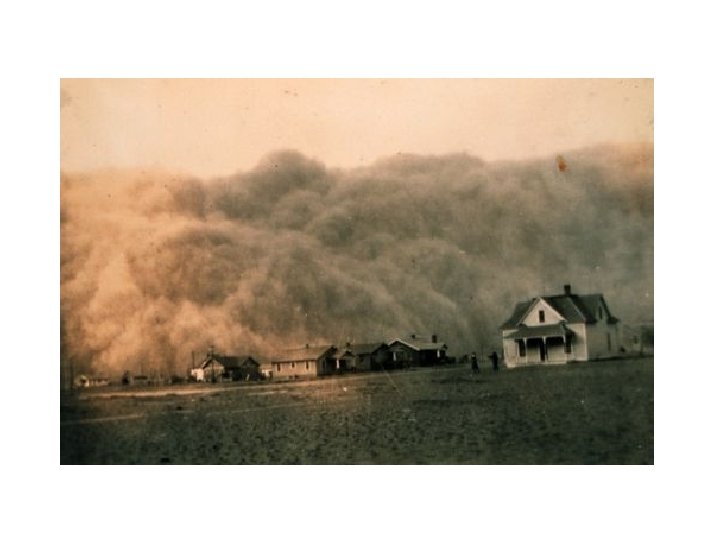
Dust Bowl
Causes of the Dust Bowl 1. Poor cultivation practices on fertile, arable lands where plowing tore up the roots of native prairie grasses (extensive root systems) which were replaced by agricultural crops (less extensive root systems). 2. After each harvest, the land was plowed and left bare for several months, exposing it to high winds.
Causes of the Dust Bowl 3. Overgrazing destroyed large expanses of grass, denuding the ground. 4. Drought – occurred between 1926 and 1934.
Journalists Name the “Dirty Thirties” the “Dust Bowl” • During May, 1934, a cloud of topsoil blown off the Great Plains (1, 500 miles away) blanketed most of the eastern United States (Washington D. C. and New York City). • The same day, Hugh Bennett of the U. S. Department of Agriculture (USDA) was in Washington as the dust arrived pleading for new programs to protect the country’s topsoil and farmers.
Washington D. C. /Hugh Bennett
Did We Learn Our Lesson From the Dust Bowl? • 1935 – USA passed the Soil Conservation Act which established the Soil Conservation Service (SCS), now called the Natural Resources Conservation Service (NRCS), and began promoting sound conservation practices, initially in the Great Plains States and then in each County in every state! Soil Survey’s were developed. • Farmers who migrated to California began using the land more sustainably and invited assistance from USDA and Soil Conservation Service. ‘No till farming” was introduced where the soil is disturbed slightly by making slits in rows in which seeds are planted.
Soil Protection Regulations • 1973 – Sediment Pollution Control Act – requires that no land-disturbing activity during periods of construction or improvement to land shall be permitted in proximity to a lake or natural watercourse unless a buffer zone is provided along the margin of the watercourse AND the angle for graded slopes and fills cannot be greater than the angle which natural vegetation can be established and retained for soil anchorage (slope stabilization). • A Sediment and Erosion Control Plan MUST be submitted and approved by the regulatory agency overseeing the project.
Sediment Pollution Control Act 1973 Coir Fiber matting Silt Curtain Hay Bales Biologs Tack
Farmland Preservation Act • State agencies must establish agricultural land preservation policies and working agreements with the USDA. • The goal is to minimize farmland conversions from agricultural zoning to residential and industrial zoning. • For approved conversions and Utility projects, the USDA reviews and ensures that Plans contain construction and restoration standards that leave affected areas in good condition after projects are completed.
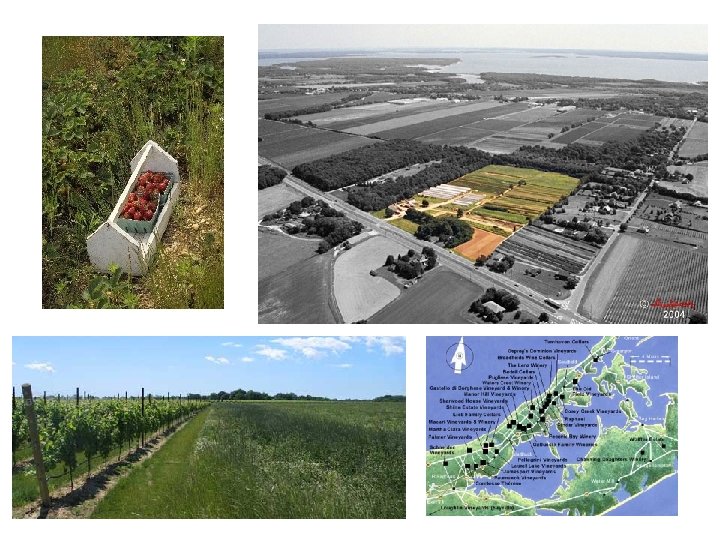
Farmland Preservation on Long Island • Town of Southhold Leads the Way! • Work with Long Island Farm Bureau, Peconic Land Trust, and Southold Town Farmers to Preserve Farmland from ever being developed. • If a farmer has to raise cash from his land he has two options: #1. Subdivide the land pursue a maximum-intensity subdivision at the current zoning (2 -acre). • #2. Look into the benefits of the farmland preservation program. • Recent experience shows that if a farmer wants to build 1 or 2 houses on his farm parcel, and sell the development rights to the remainder of his land, his net return is nearly the same as a fullintensity subdivision. • The advantage of selling the development rights to the Land Trust is that he can continue to own and farm the preserved land making additional money AFTER fair compensation received ($25, 000/acre) for selling the development rights. • This achieves the Town's preservation goals and has become an increasingly popular preservation tool, known as a Conservation Opportunity Subdivision (COS).
Town of Southold • Presently, 1 house for every 5 acres of land may built in the Town of Southold = 2 acre zoning in developments. • Over 3, 500 acres of farmland have been preserved in Southold due to the Development Rights Program (begun in Suffolk County in 1974). • In actuality 1 house is developed for every 18 acres preserved in Southold! • The Town can pay “fair compensation” to farms for transfer through a 2% Transfer Tax” for real estate sales on all other properties in the Town! Fair compensation is considered to be $25, 000/acre. • To maintain the success of the DRP and COS is to ensure that fair compensation remains consistent with full-intensity development costs.
Farm Act - 1985 • Farmers are given subsidies for highly erodible land. • They MUST take the land out of production for 10 years. • The land may NOT be farmed, grazed of cut for hay OR farmer must pay back subsidy! • This has cut erosion by 60% in the USA since 1985. • “Swampbusters” is part of the Farm Act – denies federal funding to farmers who drain or destroy wetlands on their property.
A Look at Hydroponic and Aeroponic Crop Production • Hydroponics – based on the idea that plants will grow as long as they have air, water, nutrients, and energy, but not necessarily soil. – Two Types: a. Water culture – where roots of plants are in water instead of soil, air is pumped in, and nutrients are added. b. Aggregate Culture – where plants are placed in sand, gravel, or peat which supports the plant and lets air get to the roots like soil does. Nutrients are added.
Aeroponics • Aeroponics is a hydroponic technique involving the use of sprayers, nebulizers, foggers, or other devices to create a fine mist of solution to deliver nutrients to plant roots. Fog Feed Technique Drip Irrigation Technique Root Mist Technique
Disadvantage of Hydroponic Systems • High cost of construction, equipment, fuel, and skilled workers. • Large-scale operations don’t exist. • It is suitable for places where land or water is too scarce or too valuable to use for farming such as in cities (roof-top community gardens), not useful for large-scale operations.
Soil-less Solutions Hydroponics Aeroponics
Ground Water Resources • Freshwater on/below Earth’s surface = 3% • Saltwater = 97%
Groundwater • Precipitation infiltrates and percolates downward through soil pore spaces and rock crevices and is stored below ground. • Groundwater surplus = higher than normal water table. • Groundwater deficit = lower than normal water table.
Water Budget Water Surplus Input>output Average WT Water Deficit Input<output
Aquifers • Aquifer – porous soils allow for water to accumulated in layers of sand gravel confined by clay layers (confining layers)
Long Island – Sole Source Aquifer
Groundwater Recharge Areas • Recharge Areas – any area of land where water passes downward or laterally into an aquifer. Example: Long Island Pine Barrens or Development Recharge Basins “sumps”.
Long Island’s Groundwater Recharge
Freshwater Uses • Irrigation – 16% • Energy Production & Cooling – 25% • Domestic/Municipal use – 10% • (mostly developed nations) • Agriculture and Industrial Processing – 50% Eastern USA – plenty of water Western USA – arid region = water shortages Long Island – Sole Source Aquifer
Causes of Water Shortages • Dry Climate • Drought Precipitation (low), Evapotranspiration and evaporation (high) • Dessication (drying out) • Water stress as population increases (Las Vegas) • Precipitation = 10 cm/yr; 64% water usage by homeowners for lawns and gardens! • Result = water diversion from Colorado River to meet water consumption needs.
Water Rights in the USA East “Riparian Rights” -As per needed basis as long as there is enough water left for downstream areas. West “First Come-First Serve” basis -legal rights to usage; groundwater belongs to the owner of the land above it! They can use as much as they want, divert it or sell it to make a profit! Garrett Hardins – “Tragedy of the Commons” (+FBL)
Ogallala Aquifer Wyoming S. Dakota Nebraska Colorado Kansas New Mexico Oklahoma Texas
Ogallala Aquifer • World’s largest aquifer • Water is 15, 000 – 30, 000 years old (nonrenewable) • VERY SLOW recharge rate • Used for: irrigation (20%) and farming (40%)
Ogallala Aquifer Problems 1. Water is diverted into arid lands which are normally NOT arable. 2. Subsidies provided to farmers to divert water in an effort to decrease government “crop disaster “ payments to farmers who lose their crop due to drought. The government encourages “groundwater mining” by giving tax breaks = +FBL 3. Water experts expect the Ogallala to be “economically depleted” by 2020 at current consumption rate. 4. Native Americans lost rights to water on what was originally their land due to “settler’s Appropriation Rights”!
Colorado River
Colorado River Diversion • • 1, 400 miles long Headwaters – glacial in Colorado Rocky Mountains Mouth – Gulf of California, Mexico Federal Energy Regulatory Commission (FERC) and US Army Corps of Engineers (ACE) licensed 17 major hydropower dams and 100 minor dams. • Water is diverted to farmers to grow water thirsty crops such as alfalfa and ranchers (80%) as far away as California’s Imperial Valley and to cities including Las Vegas.
Hydropower Dams Along the Colorado River
Subsidies • Water is subsidized by taxpayers for construction of dams. • This presents a false, low cost of water to consumers in this extremely arid region. • Native Americans have lost rights because of settler’s Appropriation Rights. • Water allotments in USA have been exceeded, leaving a trickle of water for Mexicans. • Water quality is compromised and biodiversity decreases.
Gulf of California, Mexico
Should Water Be Privatized? • Pros to privitization of water – when a resource is an “investment” better care is taken of the resource. • Cons to privitization of water – water is a common resource for all people to use. Is it fair to allow corporations to control common resources? • Tragedy of the commons – overuse and depletion of common resources. • Mind-set is “If I don’t use it, someone else will” • (Video)
Water Wars in the Middle East Jordan River Turkey Syria Jordan Syria Iraq Nile River Ethiopia Sudan Israel Egypt Tigris. Euphrates Turkey Syria Iraq Israel Jordan River
Jordan River • Israel – irrigates 2/3 of its croplands, but uses water more efficiently than any other country in the world. • Jordan – 75% of water from Jordan River basin. With population on the rise, water shortages could cause Jordan to declare war on Israel for water useage. • Syria – gets water from Jordan and the Euphrates-Tigris rivers. Syria is closest to headwaters for Jordan River. They plan to build many dams for water diversion. This will limit water going to Jordan and Israel. • Israel threatens to “destroy” dams in Syria.
Tigris-Euphrates River • Turkey – is situated at the headwater and they plan to build 22 dams along the upper Tigris and Euphrates for hydroelectric plants and for irrigation. • Turkey plans on diverting water from dams via pipelines to Saudi Arabia, Kuwait and possibly Syria, Israel and Jordan. • Syria – gets 90% of its water from the Euphrates. • Iraq – will be left with very little water.
Nile River • Ethiopia – control 85% of the headwaters. • Sudan uses approximately 10 %. • Egypt – the last to get water along the Nile (5%). Egypt has a thin area of irrigated cropland, the rest of Egypt is desert. • PROBLEM: Egyptian population grows by 1 million every 9 months!
What Can Egypt Do? • Declare war on Sudan and Ethiopia • Decrease population growth • Save water by improving irrigation efficiency and drought resistant crops • Spend 2 billion dollars and pump water from Lake Nasser (reservoir at the Aswan High Dam) • Import more grain to feed population • Work out water-sharing agreements with other countries. • Suffer human and economic losses.
How Can Water Problems Be Resolved? 1. Decrease 2. 3. 4. 5. 6. 7. population! 1. 2 billion lack access to clean drinking water 2. 2 billion live without Sewage Treatment Plants (STP’s) 2/3 of the world households do NOT have running water. Must be a global commitment to sharing this rare and valuable resource sustainably! Build dams to store water in (reservoirs) Transfer water from other places. Build desalination plants (USA engineers) Improve efficiency in water usage Conserve water.
Why Is Water Wasted In the USA? • Artificially low prices of water resulting from government subsidies (externalities not including in your water bill). • Promotion of growing water thirsty crops such as alfalfa in California and Arizona! The government makes water SO cheap and easily accessible through water transfer from Colorado River that farmers grow these crops. • The US Bureau of Reclamation supplies ¼ of all water used to irrigate lands to the western USA under Long. Term Contracts at greatly subsidized prices from our taxes! • Watershed Management is divided between state and local governments in the western USA, there is not 1 Authority in control. Long Island has a Regional Water Authority (Suffolk County Water Authority) and we are in much better shape, but water is still ridiculously cheap.
Suffolk County Water Authority • Annual Reports on the Quality of Your Drinking Water are mailed out each spring to each resident in Suffolk County. • You can view them online as well. • www. scwa. com/residential/yourdrinkingw ater. cfm
How Can We Conserve Water in the USA? • Efficiency improvement • Flood irrigation through gravity flow • Center-pivot sprinklers (low to ground = less evaporation. (costs are high initially; farmers don’t use them) • Drip Systems – release trickle of water near plant roots. High initial costs. • Computer controlled systems – monitor soil moisture and turn on irrigation systems as needed (high initial costs) • Switch to xerophytic crops (little water needed) = xeroscaping. • Consumer should pay true cost of water (include externalities) • Provide subsidies for conservation methods that have high initial start-up costs! • Treat wastewater to irrigate non-edible crops.
What You Can Do • Turn faucet off when brushing teeth – (saves 9 gallons of water) • Fill up sink when shaving (saves 14 gallons of water) • Fill kitchen sink with water to wash pots and pans (saves 25 gallons of water) • When washing car, do not leave hose running (saves 150 gallons of water) • Self service car wash uses only 10 gallons of water • Sponge and bucket uses only 15 gallon of water. • Flushing a toilet uses 5 -7 gallons of water – put a displacement device in tank and reduce it to 2 -3 gallons of water per flush.
What Can You Do? • Install low flow shower head. Decreases water use by 35 gallons for every 5 minutes you are in the shower. • Reduce the time spent in the shower! • Install low flow aerator faucet heads ($4. 00 at Home Depot or Hardware Store). Reduces water use by 50%. • Use Phosphate-free detergents (Mandatory in Nassau and Suffolk) to decrease cultural eutrophication. • To Prevent Groundwater Contamination DO NOT dispose of paint, paint thinner, oil, grease or any other material labeled as hazardous or toxic into the environment or down the drain. • Town of Islip has special pick ups through WRAP program (1 in fall, 1 in spring) OR you can bring these materials to the Islip Town recycling centers.
Groundwater Contamination • Groundwater is the primary source of drinking water and irrigation. • Contamination Sources: a. Livestock waste b. Underground storage tanks (leak fuel and MTB’s) c. Landfills (leach materials breaking down (metals, hdyrocarbons, etc. ) d. Abandoned hazardous waste sites leach heavy metals and solvents into groundwater.
Sanitary Landfill
Groundwater Protection in USA • Clean up is VERY expensive; and technically not feasible. • PREVENTION IS BEST! • US Safe Drinking Water Act, 1974 – EPA established national drinking water standards e. 0 coliform bacteria colonies per 100 m. L of water. • (Recall Clean Water Act does not protect groundwater)
EPA MANDATES • 1992 survey showed that 40% of the US drinking water contained parasitic organisms of Cryptosporidium sp. , but not Giardia sp. • 1996 – EPA mandated that ALL Public Water Suppliers (Suffolk County Water Authority) test for Cryptosporidium sp. , but not Giardia sp. • There are 255 chemicals and compounds that the government requires we monitor in our drinking water Cryptosporidium sp. Giardia sp.
Who Has Too Much Water? • When there is too much water or soils are persistently saturated, rain events can cause disastrous flooding. • Humans have contributing to increased flooding from: a. deforestation b. Mining c. Overgrazing d. urbanization (hard surface increase leads to infiltration decrease)
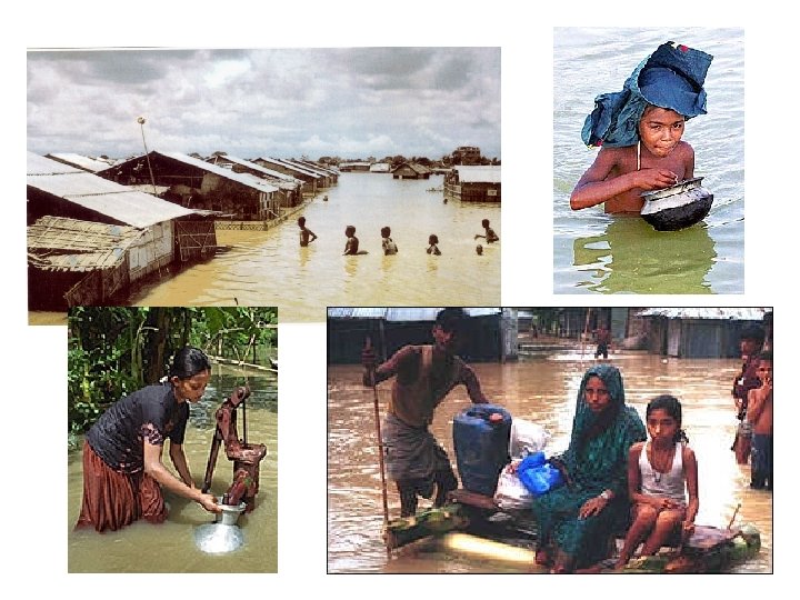
Bangladesh
Bangladesh • 123 million people in one of the poorest countries in the world and 80% of the population live along the shoreline where there are rich, fertile soils. • Average per capita GNP = $260. 00 = 71 cents/day! • Monsoon season brings continuous flooding during the summer months. It appears to be cyclic and that every four years there are significant monsoonal events since the 1970’s (historically it was about every 50 years!)
Why Does Bangladesh Flood So Frequently? • Rapid population increase has changed the natural character of the land by: a. Deforestation which has promoted significant soil erosion. b. Overgrazing c. Unsuitable farming (steep slopes) and unsound farming practices on these slopes. d. Cleared coastal mangrove forests to provide land to grow rice. They have removed the wetland structures and decreased or removed the functions they need to survive along the coastlines. e. No money to restore mangrove swamps! RESULT: Millions of homes are destroyed each year, thousands of people drown. 30 million people become environmental refugees each year.
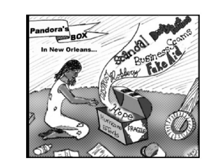
How Do We Reduce Flood Risks? • Channelization to divert water away from communities can have both positive and negative effects. (Florida Everglades are destroyed from ACE water diversion) • Build levees and dams – when they break = disaster (Hurricane Katrina) • Restore wetland systems (never achieve 100% replacement of structure and functions) • Establish Flood Plain Management Plans – How about don’t build in the flood plain? !! • PREVENTION IS BEST!
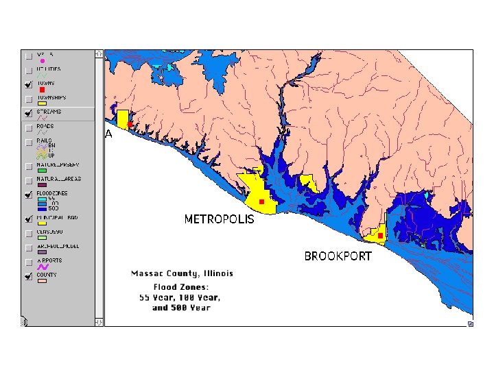
FEMA • Federal Emergency Management Agency • Provide Flood Plain Maps for every County in the USA. Designed for Insurance Companies. • Delineate 500 year storm flood elevation • Delineate 100 year storm flood elevation • Delineates entire flood plain area.