A Cartesian coordinate system is a coordinate system


 Coordinates Rectangular (Cartesian) Coordinates")

 Coordinate System • Latitude = angle")

 Latitude is comprised of parallels, which are equally spaced")
 or in Decimal Degrees (DD) As for")


 is a spherical, or angular, coordinate system. Angular coordinates are")
 The point of origin for latitude and longitude on")


 run north to south, but they partition the earth")
- Slides: 31
A Cartesian coordinate system is a coordinate system that specifies each point uniquely in a plane by a pair of numerical coordinates, which are the signed distances to the point from two fixed perpendicular directed lines, measured in the same unit of length.
There are two types of global coordinate systems: Angular (geographic) Coordinates Rectangular (Cartesian) Coordinates Latitude and longitude (an angular coordinate system) and Universal Transverse Mercator (a rectangular coordinate system) are the most common global coordinate systems used with the Global Positioning System. However, other coordinate systems are also available in GPS receivers
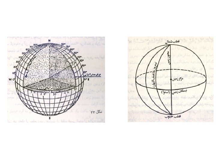
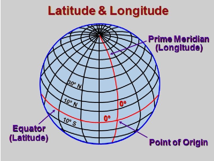
Latitude and Longitude • A Spherical (not Planar) Coordinate System • Latitude = angle traced between the Equator, the center of the Earth and the point. • Longitude = angle traced between the Greenwich Meridian, the center of the Earth and the point.
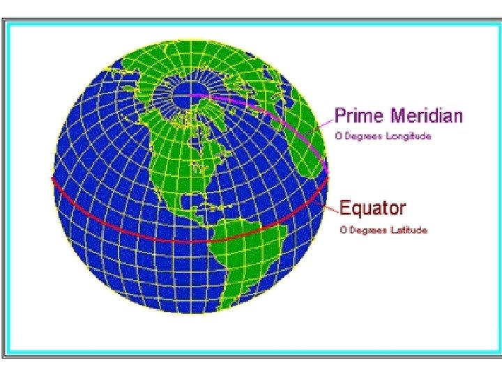
The Prime Meridian runs north and south through Greenwich, England (specifically through the Royal Naval Observatory located in the town of Greenwich). The equator runs east and west around the earth’s mid section. Where the two intersect is expressed as “ 0 degrees north latitude, 0 degrees east longitude. ” Everything west of the Prime Meridian is defined as “west longitude, ” and everything east is defined as “east longitude. ” Similarly, everything north of the equator is defined as “north, ” and everything south is defined as “south. ”
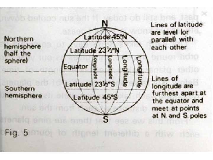
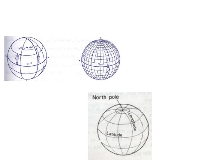
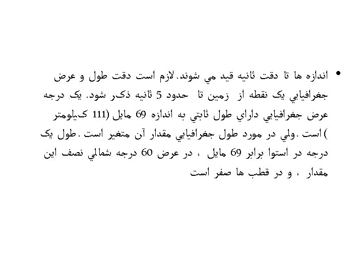
Latitude & Longitude (cont. ) Latitude is comprised of parallels, which are equally spaced circles around the earth paralleling the equator. Parallels are designated by their angle north or south of the equator (10º, 20º, etc. ). The equator is 0º latitude, and the north and south poles are at 90º angles from the equator. The linear distance between parallel (latitude) lines never changes, regardless of their position on the earth. The distance between one degree parallels is approximately 69 miles, whether measured at the equator, or at the north or south poles.
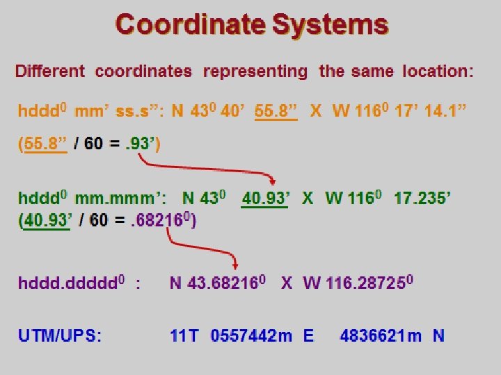
• Angle expressed in Degree-Minute-Seconds (DMS) or in Decimal Degrees (DD) As for latitude and longitude, there are three to describe coordinates: degrees, minutes and seconds: degrees and decimal minutes: decimal degrees: N 40° 23’ 45” W 98° 12’ 06” N 40° 23. 75’ W 98° 12. 1’ N 40. 395° W 98. 201° Each of the above sets of coordinates represent the same location. To convert seconds to decimal minutes, divide the seconds by 60 to get decimal minutes. To convert decimal minutes to decimal degrees, divide the decimal minutes only by 60 to get decimal degrees.
Coordinate Systems Coordinate systems provide unique descriptions of geographic positions using numeric or alphanumeric characters. Recall that datums provide coordinate systems with an earth tie (a geographic reference point), and that without a datum, coordinate values cannot reference geographic points on the ground. Datums and coordinate systems work in conjunction with each other to provide a link between maps and the physical world. There are two types of global coordinate systems: Angular (geographic) Coordinates Rectangular (Cartesian) Coordinates Latitude and longitude (an angular coordinate system) and Universal Transverse Mercator (a rectangular coordinate system) are the most common global coordinate systems used with the Global Positioning System. However, other coordinate systems are also available in GPS receivers
Think of coordinate systems as just another way of expressing a geographic location. For example, the intersection of Fifth Avenue and Main Street can also be described as “the corner where Floyd’s Barber Shop is located. ” These are merely two different ways of describing the same location. Similarly, that same geographic location can be identified using a variety of geographic coordinates, such as the UTM coordinates 17 S 0345678 E 4123678 N. Or, using latitude and longitude Floyd’s Barber Shop might be: N 40° 23’ 45” W 98° 12’ 06” (expressed in degrees, minutes and seconds). As for latitude and longitude, there are three to describe coordinates: degrees, minutes and seconds: N 40° 23’ 45” W 98° 12’ 06” degrees and decimal minutes: N 40° 23. 75’ W 98° 12. 1’ decimal degrees: N 40. 395° W 98. 201° Each of the above sets of coordinates represent the same location. To convert seconds to decimal minutes, divide the seconds by 60 to get decimal minutes. To convert decimal minutes to decimal degrees, divide the decimal minutes only by 60 to get decimal degrees. Universal Transverse Mercator (UTM) is different than latitude and longitude, so it looks and behaves differently. But it is still just another way of expressing the location of a point on a map or on the ground. The “UPS” included with UTM stands for “Universal Polar Stereographic”, a coordinate system that is a variation of UTM that is used in the north and south polar regions in place of UTM.
Latitude and longitude (lat/long) is a spherical, or angular, coordinate system. Angular coordinates are best suited for the three-dimensional shape of the earth. Points or locations are based on an angular distance from a known reference point. That reference point is where the Prime Meridian and the equator meet in the South Atlantic Ocean. In lat/long the earth is divided into 360 degrees. Each degree is divided into 60 minutes, and each minute into 60 seconds. Each second can be further broken down into fractions (or decimals) of a second. Lat/long is the predominant coordinate system used for marine and aeronautical navigation. Aircraft use degrees and decimal minutes for expressing lat/long coordinates. Mariners prefer degrees, minutes and seconds.
Latitude & Longitude (cont. ) The point of origin for latitude and longitude on the earth’s surface is where the Prime Meridian and the equator intersect. Geographically that point is just west of Africa in the South Atlantic Ocean.
Latitude lines, or parallels, run east-west around the earth, but they partition the earth into north-south slices. The distance between each degree of latitude does not change, regardless of where it lies in relation to the equator. This is different than longitude where lines converge as they approach the poles
Longitude lines are quite a bit different from latitude lines. Longitude is comprised of meridians that form one-half of a circle, or plane. So any meridian actually split the earth in half from top to bottom (pole to pole). Meridians originate at the center of the earth and radiate outward into space at specific angles. Those angles designated by their angle west or east of the Prime Meridian. The Prime Meridian is designated 0º and extends from the north pole to the south pole through Greenwich, England. Meridians do not parallel each other at an equal distance, which is the primary difference they have with lines of latitude. The linear distance between one degree of longitude at the equator is approximately 69 statute miles (same as latitude). However, the linear distance between one degree of longitude at the arctic circle is only about 26 statute miles. This is because longitude lines converge as they get closer to the poles, and diverge as they get closer to the equator.
Ø Longitude is comprised of meridians that form one-half of a circle, or plane. Ø Meridians are designated by their angle west or east of the prime meridian. Ø The prime meridian is designated 0º and extends from the north pole to the south pole through Greenwich, England. Ø Meridians are angled, and do not parallel each other. Ø The linear distance between one degree of longitude at the equator is approximately 69 statute miles. Ø The linear distance between one degree of longitude at the arctic circle is only about 26 statute miles
Meridians of Longitude lines (meridians) run north to south, but they partition the earth into east and west halves. Unlike latitude, the distance between each degree of longitude narrows as the distance away from the equator increases. One nautical mile at the equator equals one minute of longitude. However, near the North Pole, one minute of longitude is considerably less than a nautical mile across