20142015 Evaluation and ReDesign Haifa and Yafa Streets


- Slides: 36
2014/2015 Evaluation and Re-Design Haifa and Yafa Streets. Prepared By: Ameen Dasoqi Amjad Shhadi Labeeb Asa’d Supervisor: Prof. Sameer Abu-Eisheh Graduation Project
Project Definition Data Collection and Traffic Studies Data Analysis Geometric Traffic Design Control Conclusions and Recommendations
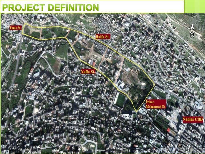
The project aims to study “Haifa and Yafa Streets” corridor, and their connections with Prince Mohammad and Tunis Streets. Specially after the new road which has been constructed recently by Nablus Municipality in order to reduce traffic on Rafidia and Haifa Streets, this road connects between Yafa Street and Prince Mohammad Street.
In this project, the researchers collected data for the traffic in the study area on a weekday before and after opening the new road, then analyzed and input these data in SYNCHRO program. Next, the new situation has been evaluated in order to solve the appeared traffic problems, considering the changes, which occur in the area where needed, modifications are proposed and examined using the same program.
Current • • • problems: Congestion Problems. Delay Problems. Pedestrian Problems. Geometric Problems. Safety Problems.
Data • Collection Constrains. the large number of intersections and the lack in the ability to count all of them at the same time.
Existing • Corridor Conditions The facilities to be evaluated in this project is the corridor of Haifa and Yaffa Streets, which are affected by the new road that was recently constructed by Nablus Municipality as indicated before.
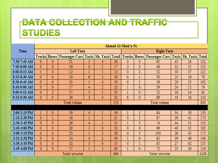
Vehicles • Count and Classifications Vehicles counting was conducting manually for four un-successive hours from of 07: 30 am to 09: 30 am and from 2: 00 pm to 4: 00 pm. And after opening it, vehicle counting was conducting for two successive hours from of 02: 00 pm to 04: 00 pm. taking into consideration vehicle classifications in terms of Passenger Cars, Taxis, Shared Taxis, Buses, and Trucks.
Coding • and Establishing the Model The analysis procedure is based on calculating the level of service (LOS) of intersections and streets, and calculating the resulting average delay per vehicle at the peak-hour which was determined to be from 2: 45 -3: 45 PM. Then, these will be compared to the LOS reached after opening the new road.
Traffic • Analysis before Opening the New Road The analysis was made for the main intersections that have clear effects on the traffic volume and distribution on the Haifa and Yaffa Streets within the study area. The other secondary intersections that have less effects on the study area than main intersections are analyzed.
Traffic • • Analysis after Opening the New Road The same procedures for the traffic analysis before opening the new road had followed for traffic analysis after opening it. The results will be discussed to examine if there is a need for any further improvement of the geometric conditions or traffic control (such as signals), and to examine if the impact of the new road on the corridor is positive or negative.
The main goal for this chapter is to maximize the comfort and safety. This chapter illustrates specific intersections and links which have failed when compared with concerned specifications, and gives some recommended suggestions in order to fix failure there. • The next few slides shows an example for the worst intersection in the study area, and shows the suggested solutions in order to solve the failure in that intersection.
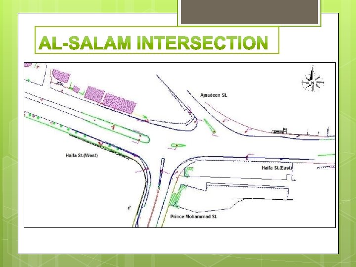
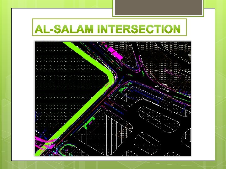
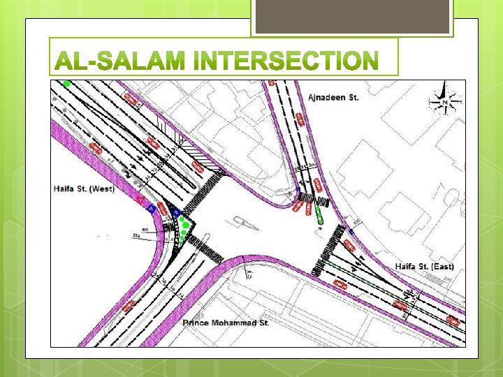
• • • The LOS for Al-Salam intersection is F as Chapter 4 shows and this is not acceptable value which may reached due to poor design and high volume. One of the suggestion to solve the problems was into converting the Prince Mohammad Street from two directions street into one direction street, and this helps a lot in order that the number of phases will get less. The next slide, shows the intersection after making specific additional modifications such as islands, marking, and adding special lanes for each movement.
• As you noted from SYNCHRO outputs, the LOS has changed after making the previous suggested modifications from F to D.
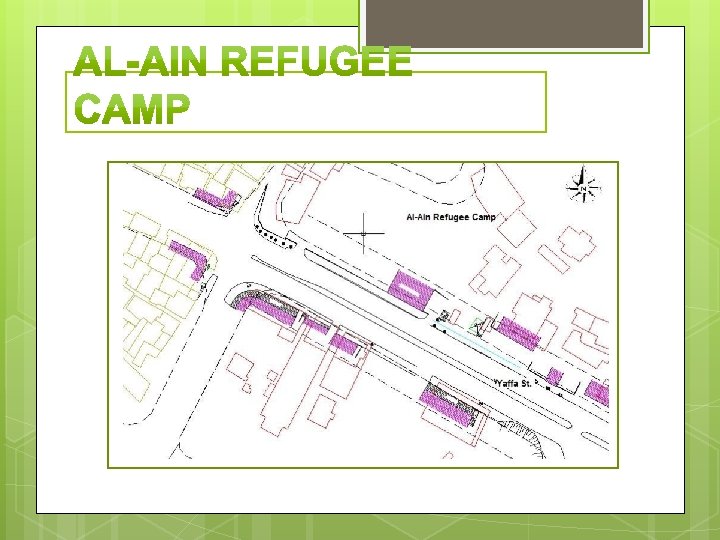
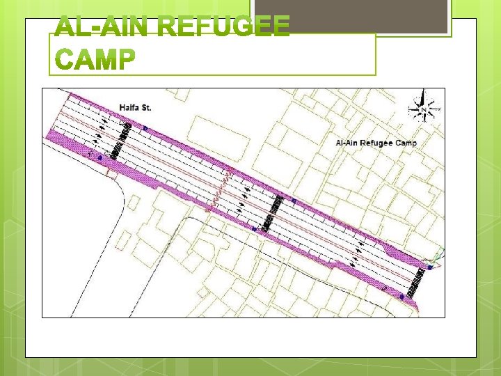
• The LOS for Al-Ain Refugee Camp link is C. This is fair but there are specific problems in the design such as: 1 - The median is 0. 9 meter. 2 - One travelling lane for each direction. 3 - No marking exists. 4 - No enough width for lanes. • The next slide shows the link of Al-Ain Refugee Camp after making specific modification in the number and width of lanes for each movment.
The project aims to study “Haifa and Yafa Streets” corridor, and their connections with Prince Mohammad and Tunis Streets. Specially after the new road which has been constructed recently by Nablus Municipality in order to reduce traffic on Rafidia and Haifa Streets, this road connects between Yafa Street and Prince Mohammad Street.
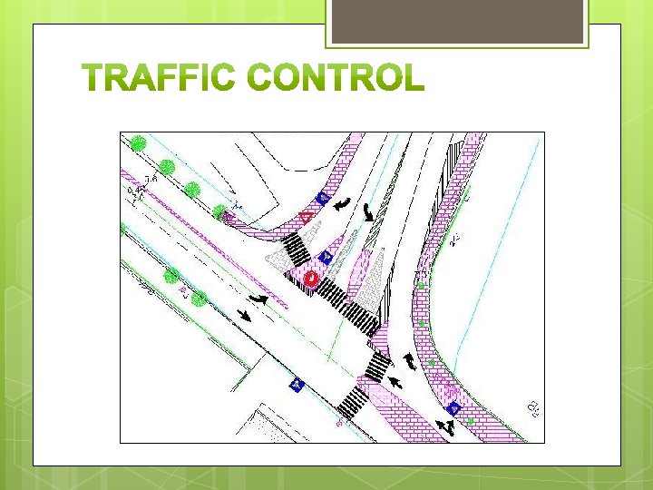
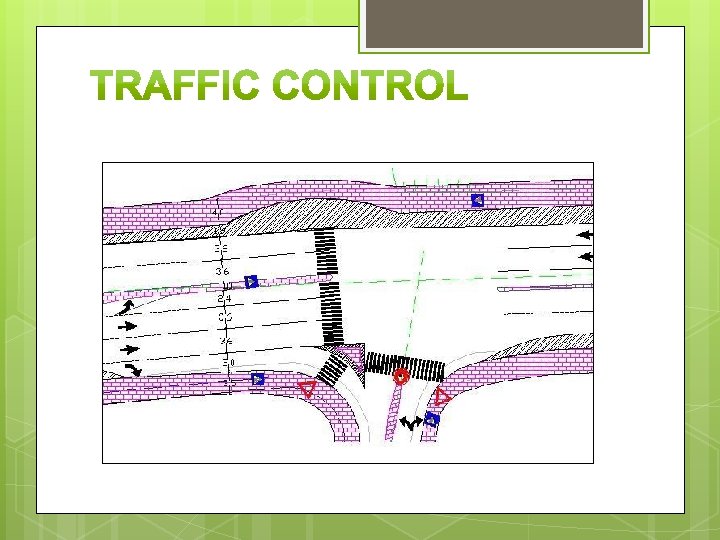
In the traffic management, the problem of transport stream control becomes the critical one under conditions of a rapid growth of the motorization level. Introduction of adequate technical facilities is one of the most important traffic management measures, based on their purpose. The traffic management devices can be subdivided into the road signs, road marking, and traffic signals.
Traffic Signals • In the study area, there are three signalizing intersections including Al-Salam, Haifa-Tunis and Ahmad Al-Shak’ah intersections. At Al-Salam intersection, before redesign, the cycle length is 100 seconds and the longest phase has a green time of 38 seconds for the traffic comes from Haifa Street (east). After traffic redesign, the cycle length is 122 seconds and the longest phase has a green time of 46 seconds for the traffic comes from Haifa Street (east). At Haifa-Tunis intersection, before redesign, the cycle length is 100 seconds and the longest phase has a green time of 42 seconds for the traffic comes from Haifa Street (west). After traffic redesign, the cycle length is 110 seconds and the longest phase has a green time of 40 seconds for the traffic comes from Haifa Street (east). • •
Road Marking • Road marking is an important traffic control device that guides the drivers on the road, including the directional arrows that painted on the road, the flushed medians, the cross walks for pedestrians, and the lines that delineated the lanes and border of street. At the study area road marking are not present except at some sections. Therefore, for the redesign, the road markings are implemented. The scheme designed shows the marking required for each intersection and section. •
Road Signs • When there is no need to use signals, road signs are considered the most popular device to control the traffic in the traffic system. In the study area road signs are currently used but not at all study area. Some of these are defected, therefore the redesign in project considered using proper signs, and clarified on scheme. Signs include stop signs used for left turn at minor streets in intersections, yield signs used for right turn at minor streets in intersections, and pedestrian crossing signs used at any cross walk. •
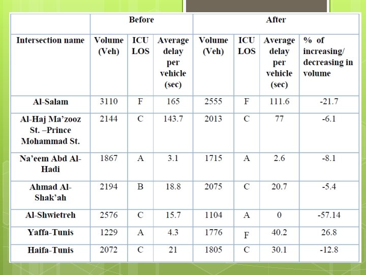
It is noticed from the comparison between the simulated traffic conditions before and after opening the new street, that opening the road has positive effects and negative effects.
Positive effects: Such as Ahmad Al-Shak’ah intersection, where the LOS value has changed to B after it was C before opening the new road, and the average delay per vehicle on the intersection reduced by 7. 0 seconds after it was 22. 1 seconds.
negative effects: Such as Yaffa-Tunis intersection, where the LOS value would change to F after it was A before opening the new road, and the average delay per vehicle would increase to 41. 8 seconds after it was 4. 3 seconds per vehicle.
Future Demand Generation A more detailed travel demand study is recommended, taking into account the future demand generation in the study area. The Cost of The Project Estimating the cost of the project, using Civil 3 D program to improve the outcomes of this project.
Traffic Count at The Surrounded Intersections Traffic Count for the intersection lies before Al-Salam intersection from east, and the roundabout in Al-Haj Ma’zooz Street. Feasibility Conducting Study the feasibility study considering the proposed alternatives then estimate the benefit to cost ratio of using the alternatives can be done to select the suitable solution in addition the specified criteria.
Thank You • • • Our Parents Prof. Sameer Abu-Eisheh Our examiner in GP 1 Our University Nablus Municipality Our Friends