2 Ocean Currents Ocean waters are constantly on


 Potential Temperatures (°C) http: //sam. ucsd. edu/sio")
 Salinity (‰)")
 Density at 0 dbar (s 0 F)")
 Density at 4 dbar (s 4 F)")
 Dissolved Oxygen (DO 2 in ml/l)")
 Silicate content (umol/Kg)")


 Potential Temperatures (°C)")
 Salinity (‰)")
 Density at 0 dbar (s 0 F)")
 Density at 4 dbar (s 4 F)")


- Slides: 35
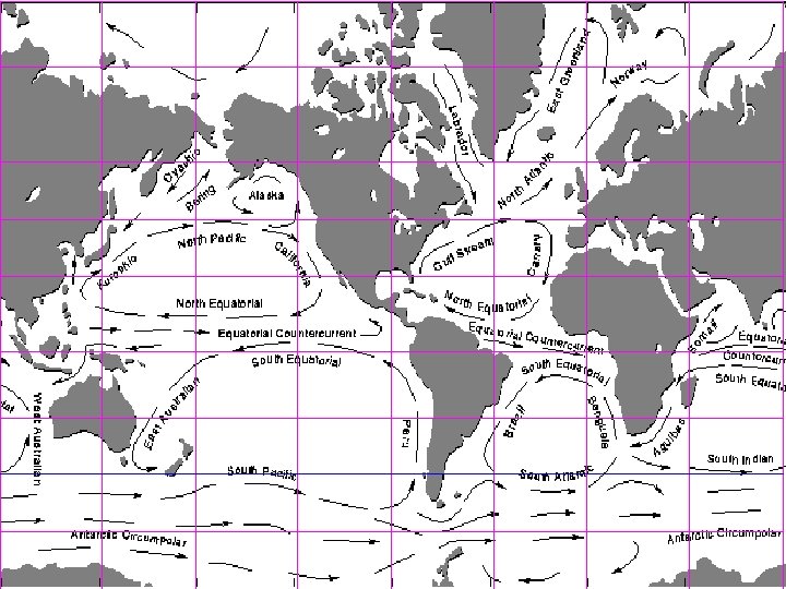
2. Ocean Currents
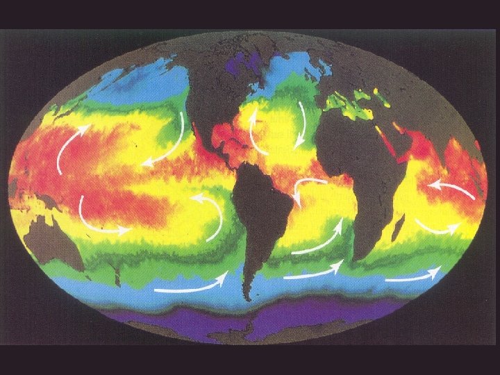
Ocean waters are constantly on the move. How they move influences climate and living conditions for plants and animals, even on land. Currents flow in complex patterns affected by wind, the water's salinity and heat content, bottom topography, and the earth's rotation.
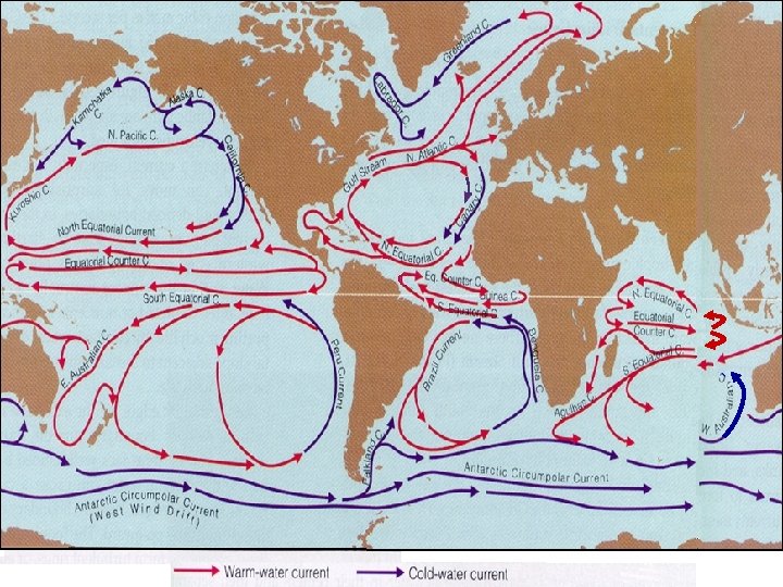
Types of Ocean Currents • Surface currents – Anti-cyclonic current gyres are driven by the westward flow of equatorial surface wind. – Gravity driven roll-back from the resulting rise of western sea surface runs equatorial counter current. – Circum-Antarctic circulation, or “West Wind Drift” is driven by Earth’s rotation. • Deep-water current – This is thermohaline circulation or the “Global Conveyor Belt”.
The North Atlantic Gyre System
The factors that govern the oceanic gyres ry na ent Ca rr Cu lf u G am re st N. Equatorial Current
Atlantic Ocean meridional section at 25°W (a) Potential Temperatures (°C) http: //sam. ucsd. edu/sio 210/lect_6/
Atlantic Ocean meridional section at 25°W (b) Salinity (‰)
Atlantic Ocean meridional section at 25°W (c) Density at 0 dbar (s 0 F)
Atlantic Ocean meridional section at 25°W (d) Density at 4 dbar (s 4 F)
Atlantic Ocean meridional section at 25°W (e) Dissolved Oxygen (DO 2 in ml/l)
South Atlantic meridional section at 25°W (e) Silicate content (umol/Kg)
Surface currents in the Paficific
Nike shoes and the Pacific gyre The North Pacific gyre has been dropping off shoes around the Pacific since 1990. The shoes washed ashore one at a time but were wearable after a scrub-down to remove barnacles, algae, and tar. Beachcombers held swap meets to find matched pairs 1. 2. 3. 4. 5. 6. 7. 8. 9. shoe spill, May 27, 1990 250 recovered, March 26, 1991 200 recovered, May 18, 1991 100 recovered, January-February 1991 200 recovered, November-December 1990 200 recovered, February-March 1991 150 recovered, April 4, 1991 200 recovered, May 9 -10, 1991 several recovered, January-March 1993
Pacific ocean meridional section at 150°W (a) Potential Temperatures (°C)
Pacific Ocean meridional section at 150°W (b) Salinity (‰)
Pacific Ocean meridional section at 150°W (c) Density at 0 dbar (s 0 F)
Pacific Ocean meridional section at 150°W (c) Density at 4 dbar (s 4 F)
Surface currents in the Indian Ocean
Circum-Antarctic Circulation
Pacific at normal times
During the El Niño Times
The normal or La Niña conditions Low air pressure Warm surface waters Equatorial surface wind Cold deep waters East West Equatoria l counter current High air pressure
Animation of Monthly-averaged Sea Surface Temperatures http: //www. nodc. noaa. gov/dsdt/sst_ani. htm
El Niño Continues to Grow: Pacific Ocean Shows Higher Than Normal Sea Surface Heights December 02, 2002 The latest image from NASA's Jason oceanography satellite, taken during a 10 -day collection cycle ending December 2, 2002, shows the Pacific dominated by two significant areas of higherthan-normal sea level (warmer ocean temperatures). In the central equatorial Pacific, the large area of higher than normal sea surface heights (warmer than normal sea surface temperatures) associated with growing El Niño conditions has recently migrated eastward toward the coast of South America. Meanwhile, the influence of the 20 - to 30 -year larger than El Niño/La Niña pattern called the Pacific Decadal Oscillation continues to create warm, higher-than-normal sea-surface heights in the north Pacific that are connected in a warm horseshoe pattern with the western and southern Pacific. http: //topex-
Geostrophic Currents Upwelling and downwelling
The Ekman Spiral
The Ekman Spiral
Mapping the Gulf Stream
The Gulf Stream wobbles, much like the streams on land, so creating rings and eddies.
The Oceanic Conveyor Belt