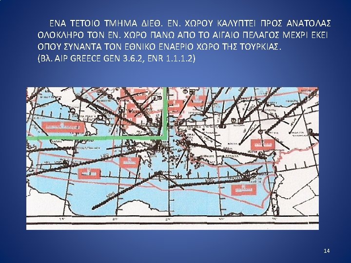
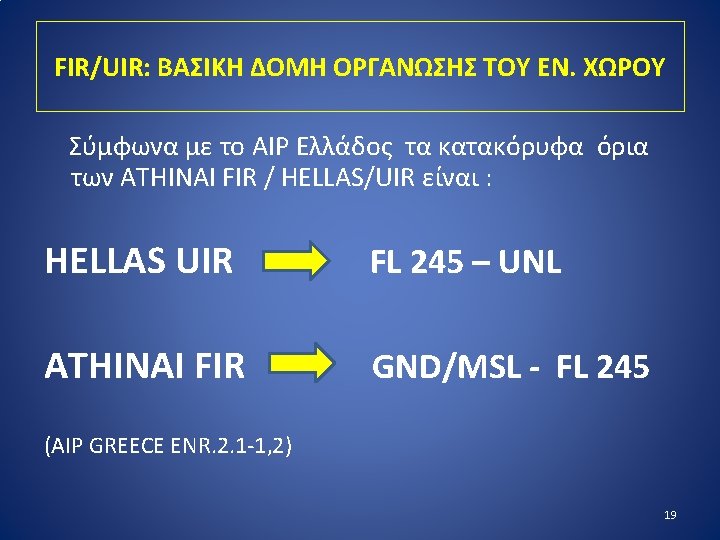
13 O ATHINAI FIR HELLAS UIR 17 20


 ΠΟΥ ΠΑΡΕΧΟΝΤΑΙ ΕΝΤΟΣ ΤΟΥ FIR Ø A. FLIGHT INFORMATION SERVICE Ø B.")
 ΕΞΥΠΗΡΕΤΗΣΗ ΠΑΡΟΧΗΣ ΠΛΗΡΟΦΟΡΙΩΝ ΠΤΗΣΗΣ «A service provided for")
 ΕΞΥΠΗΡΕΤΗΣΗ ΣΥΝΕΓΕΡΣΗΣ «A service provided to notify appropriate organizations")

 ΕΞΥΠΗΡΕΤΗΣΗ ΠΑΡΟΧΗΣ ΕΛΕΓΧΟΥ Ε. Κ. «A service provided")
 Ø")
 ΖΩΝΗ ΕΛΕΓΧΟΥ ΟΡΙΣΜΟΣ CTR: Ελεγχόμενος εναέριος χώρος ο οποίος εκτείνεται από")
 ΠΕΡΙΟΧΗ ΕΛΕΓΧΟΥ ΟΡΙΣΜΟΣ CTA: Ελεγχόμενος εναέριος χώρος ο οποίος εκτείνεται από")


 ROUTES ΔΙΑΔΡΟΜOI ΕΞΥΠΗΡΕΤΗΣΗΣ Ε. Κ. An ATS route is a")


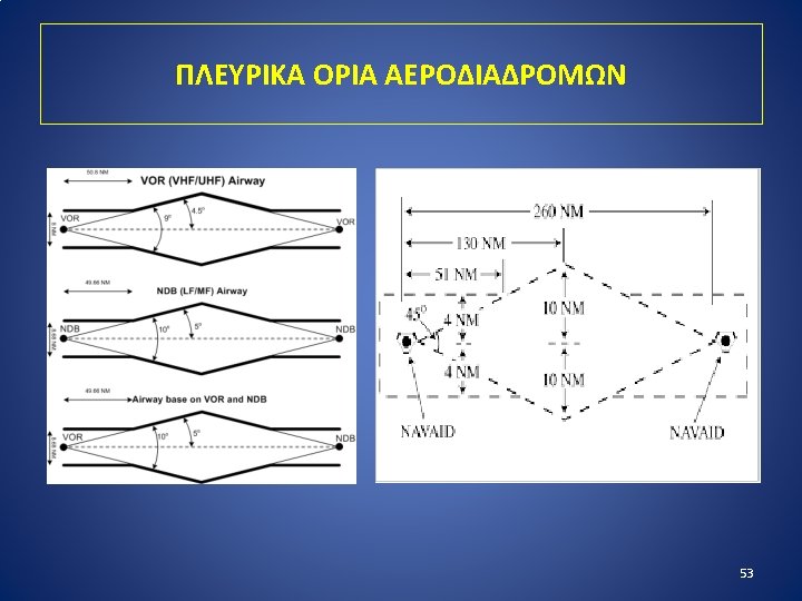
 - ΑΕΡΟΔΙΑΔΡΟΜΟΙ Το συνηθέστερο είδος ATS ROUTE είναι οι ΑΕΡΟΔΙΑΔΡΟΜΟΙ (AWYs). ΟΡΙΣΜΟΣ:")
 ΣΥΜΒΟΥΛΕΥΤΙΚΟΣ ΔΙΑΔΡΟΜΟΣ Ø 2.")

 «A prohibited area is an airspace of defined dimensions, above")
 «A restricted area is an airspace of defined dimensions above")
 «A danger area is an airspace of defined dimensions within")
 (ΠΡΟΣΩΡΙΝΑ ΔΕΣΜΕΥΜΕΝΕΣ ΠΕΡΙΟΧΕΣ) CONTROLLED FIRING AREA (ΠΕΔΙΟ ΒΟΛΗΣ) Ø Airspace")
- Slides: 67
13
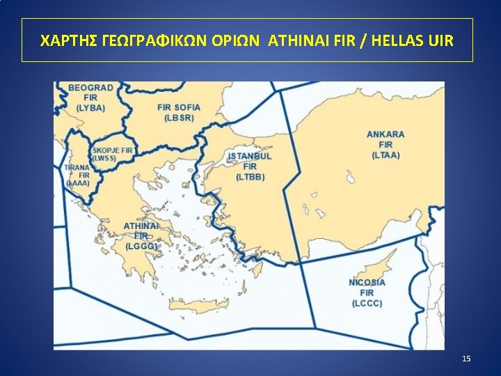
ΓΕΩΓΡΑΦΙΚΑ OΡΙΑ ATHINAI FIR / HELLAS UIR 17
20
21
ΕΞΥΠΗΡΕΤΗΣΕΙΣ (ΥΠΗΡΕΣΙΕΣ) ΠΟΥ ΠΑΡΕΧΟΝΤΑΙ ΕΝΤΟΣ ΤΟΥ FIR Ø A. FLIGHT INFORMATION SERVICE Ø B. ALERTING SERVICE Ø C. AIR TRAFFIC ADVISORY SERVICE Ø D. AIR TRAFFIC CONTROL SERVICE 22
Α. FLIGHT INFORMATION SERVICE (FIS) ΕΞΥΠΗΡΕΤΗΣΗ ΠΑΡΟΧΗΣ ΠΛΗΡΟΦΟΡΙΩΝ ΠΤΗΣΗΣ «A service provided for the purpose of giving advice and information useful for the safe and efficient conduct of flights» … (ICAO DOC. 4444 DEFINITIONS). 23
Β. ALERTING SERVICE (AS) ΕΞΥΠΗΡΕΤΗΣΗ ΣΥΝΕΓΕΡΣΗΣ «A service provided to notify appropriate organizations regarding aircraft in need of search and rescue aid, and assist such organizations as required» … (SAR) (ICAO DOC. 4444 DEFINITIONS). 24
C. AIR TRAFFIC ADVISORY SERVICE ΣΥΜΒΟΥΛΕΥΤΙΚΗ ΕΞΥΠΗΡΕΤΗΣΗ Ε. Κ. «A service provided within advisory airspace to ensure separation, insofar as practical, between aircraft which are operating on IFR flight plans» . The objective of the air traffic advisory service is to make information on collision hazards more effective than it would be in the mere provision of flight information service. It may be provided to aircraft conducting IFR flights in advisory airspace or on advisory routes (Class F airspace). 25
D. AIR TRAFFIC CONTROL SERVICE (ATC) ΕΞΥΠΗΡΕΤΗΣΗ ΠΑΡΟΧΗΣ ΕΛΕΓΧΟΥ Ε. Κ. «A service provided for the purpose of: a) preventing collisions 1) between aircraft, and 2) on the manoeuvring area between aircraft and obstructions, and b) expediting and maintaining an orderly flow of air traffic» . 26
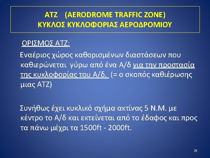
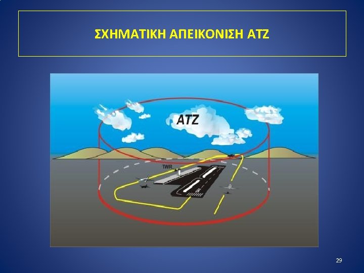
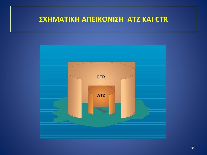
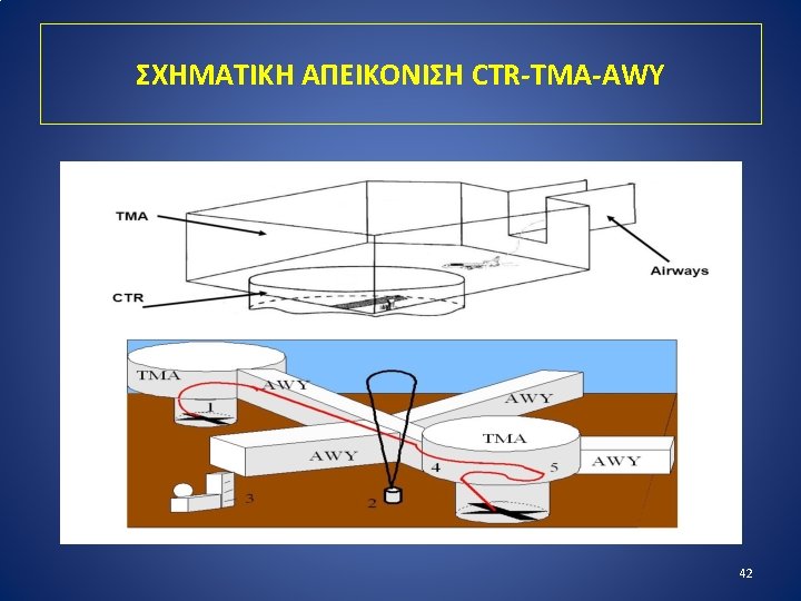
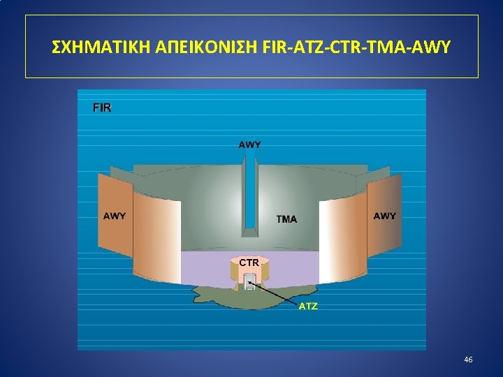
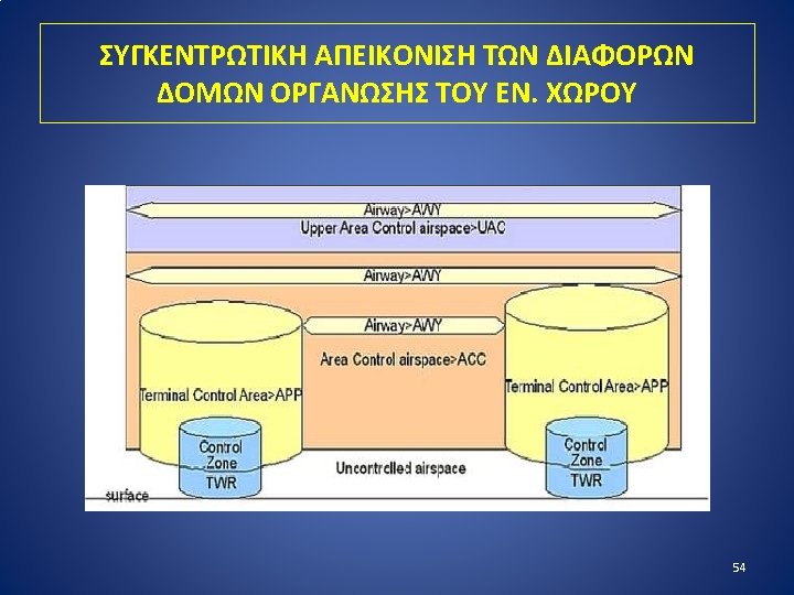
ΔΟΜΕΣ ΟΡΓΑΝΩΣΗΣ ΤΟΥ ΕΝ. ΧΩΡΟΥ ΕΝΤΟΣ ΤΟΥ FIR/UIR Ø ATZ (AERODROME TRAFFIC ZONE) Ø CTR (CONTROL ZONE) Ø CTA (CONTROL AREA) 1. TMA (TERMINAL CONTROL AREA) 2. AWY (AIRWAY) Ø ATS ROUTES 1. AWY (AIRWAY) 2. ADR (ADVISORY ROUTE) 3. CDR (CONDITIONAL ROUTE) 4. RNAV (AREA NAVIGATION ROUTE) 27
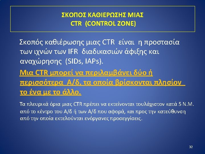
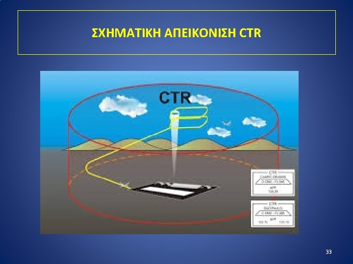
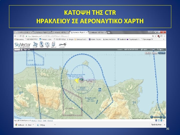
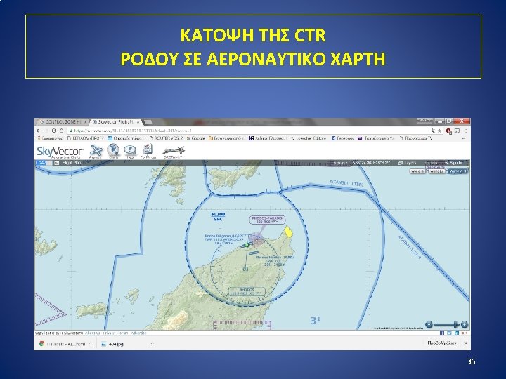
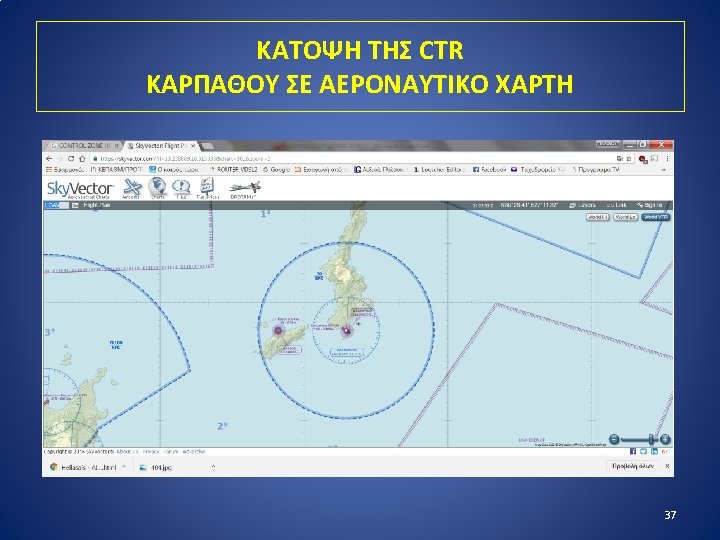
CTR (CONTROL ZONE) ΖΩΝΗ ΕΛΕΓΧΟΥ ΟΡΙΣΜΟΣ CTR: Ελεγχόμενος εναέριος χώρος ο οποίος εκτείνεται από την επιφάνεια της γης και προς τα πάνω μέχρι ενός καθορισμένου ορίου. «A control zone is a Controlled Airspace extending upwards from the surface of the earth to a specified upper limit» (ICAO Annex 11 — Air Traffic Services) (The lateral and vertical extent of control zones is detailed in the appropriate national AIP). 31
CONTROL AREA (CTA) ΠΕΡΙΟΧΗ ΕΛΕΓΧΟΥ ΟΡΙΣΜΟΣ CTA: Ελεγχόμενος εναέριος χώρος ο οποίος εκτείνεται από ένα καθορισμένο όριο πάνω από την επιφάνεια της γης. «A control area is a Controlled Airspace extending upwards from a specified limit above the earth» . (ICAO Annex 11 — Air Traffic Services) The lateral and vertical extent of control areas is detailed in the appropriate national AIP. Το κατώτατο όριο μιας CTA καθορίζεται με τρόπο που να επιτρέπει τις πτήσεις VFR (συνήθως 1000 ft – 1500 ft ή και ψηλότερα). 38
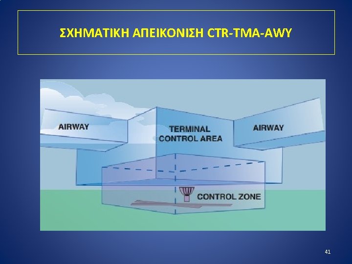
Ο ΟΡΟΣ «CTA» ΑΦΟΡΑ ΣΕ TMA Η ΣΕ AWY CTA TMA AIRWAY 39
MYKONOS TMA/CTR SYROS CTR 44
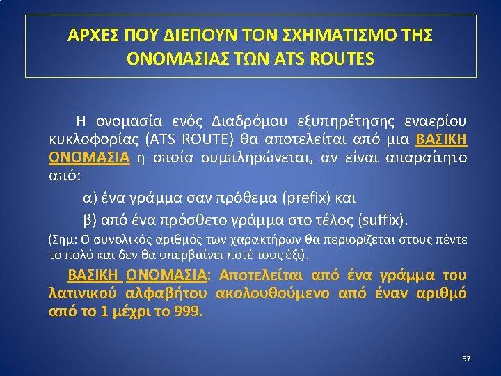
AIR TRAFFIC SERVICE (ATS) ROUTES ΔΙΑΔΡΟΜOI ΕΞΥΠΗΡΕΤΗΣΗΣ Ε. Κ. An ATS route is a specified route designed for channelling the flow of traffic as necessary for the provision of air traffic services. The term «ATS Route» is used to mean variously, airway, advisory route, controlled or uncontrolled route, arrival or departure route, etc. (AWY, ADR, RNAV, CDR, SID, IAP, STAR) An ATS route is defined by route specifications which include an ATS route designator, the track to or from significant points (waypoints), distance between significant points, reporting requirements and, as determined by the appropriate ATS authority, the lowest safe altitude. (ICAO Annex 11 - Air Traffic Services) The specifications of ATS routes are published in national AIPs. 47
ATHINAI FIR/HELLAS UIR ATS ROUTES CHART 48
EUROCONTROL ATS ROUTE NETWORK CHART 49
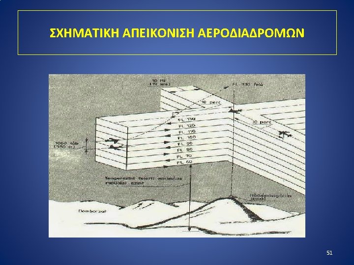
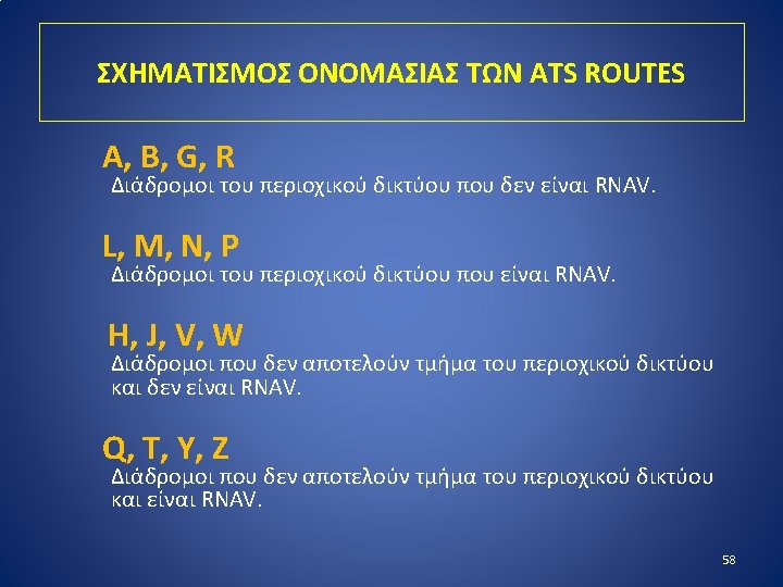
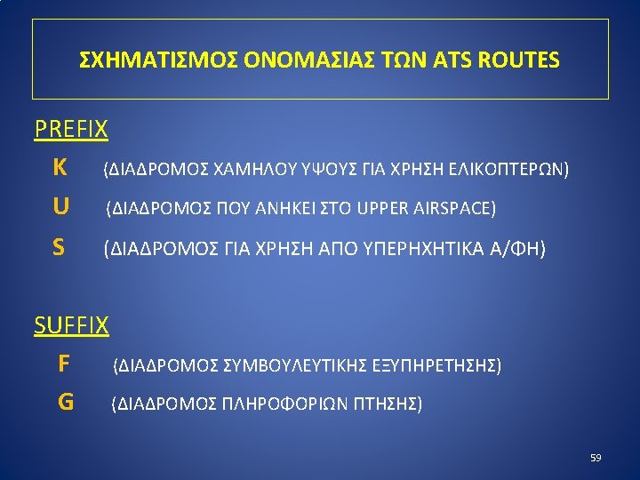
AIRWAYS (AWYs) - ΑΕΡΟΔΙΑΔΡΟΜΟΙ Το συνηθέστερο είδος ATS ROUTE είναι οι ΑΕΡΟΔΙΑΔΡΟΜΟΙ (AWYs). ΟΡΙΣΜΟΣ: Αεροδιάδρομος είναι ελεγχόμενη περιοχή ή τμήμα αυτής, που καθιερώνεται σε σχήμα διαδρόμου. «An airway is a Control Area or portion thereof established in the form of a corridor» . (ICAO Annex 11 - Air traffic Services) The lateral and vertical extent of airways is detailed in the appropriate national AIP. 50
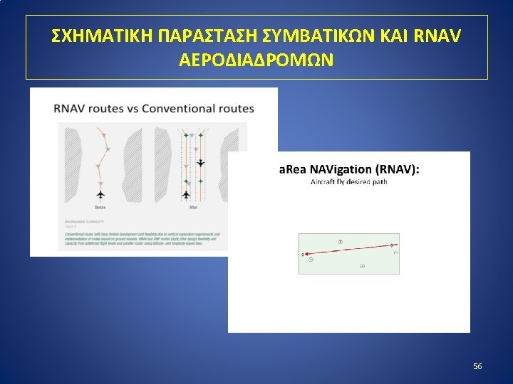
MORE TYPES OF ATS ROUTES Ø 1. ADR (ADVISORY ROUTE) ΣΥΜΒΟΥΛΕΥΤΙΚΟΣ ΔΙΑΔΡΟΜΟΣ Ø 2. CDR (CONDITIONAL ROUTE) ΔΙΑΔΡΟΜΟΣ ΔΙΑΘΕΣΙΜΟΣ ΥΠΟ ΠΡΟΫΠΟΘΕΣΕΙΣ • CDR 1: Permanently plannable. • CDR 2: Non-Permanently plannable. • CDR 3: Not plannable CDR. Ø 3. RNAV ROUTE (AREA NAVIGATION ROUTE) ΔΙΑΔΡΟΜΟΣ ΠΕΡΙΟΧΙΚΗΣ ΑΕΡΟΝΑΥΤΙΛΙΑΣ 55
ΠΑΡΑΔΕΙΓΜΑΤΑ ΟΝΟΜΑΣΙΑΣ ATS ROUTES A 14 / UA 14 KRK-ARA-TRL-MIL-SIT-KAVOS L 53 / UL 53 (RNAV) OLGAT-KRK-KOR-ABILO B 1 SKP-ATV-DDM-SOKRI-PLH-ARLOS J 62 MKN-RIPLI-SNI-IRA M 872 / UM 872 (RNAV) LATAN-KFN-PLH-METRU Y 302 / UY 302 (RNAV) GARTA-ZAK W 85 F 60
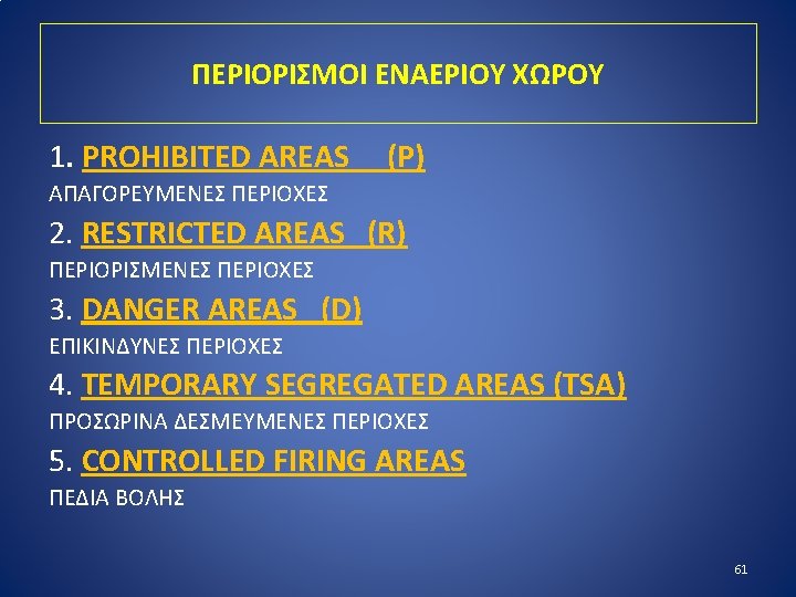
PROHIBITED AREAS (ΑΠΑΓΟΡΕΥΜΕΝΕΣ ΠΕΡΙΟΧΕΣ) «A prohibited area is an airspace of defined dimensions, above the land area or territorial waters of a state, within which the flight of aircraft is prohibited» . (ICAO Annex 2: Rules of the Air) Καθιερώνονται ΜΟΝΟ πάνω από ΕΠΙΚΡΑΤΕΙΑ The vertical and lateral dimensions of prohibited areas are published in national AIPs together with the hours of operation where applicable. Example: LGP 1 ACROPOLIS 62
RESTRICTED AREAS (ΠΕΡΙΟΡΙΣΜΕΝΕΣ ΠΕΡΙΟΧΕΣ) «A restricted area is an airspace of defined dimensions above the land areas or territorial waters of a State, within which the flight of aircraft is restricted in accordance with specific conditions» . (ICAO Annex 2: Rules of the Air) Καθιερώνονται ΜΟΝΟ πάνω από ΕΠΙΚΡΑΤΕΙΑ The vertical and lateral dimensions of restricted areas are published in national AIPs together with the hours of operation where applicable. Example: LGR 15 PLATFORM “A” PRINOS KAVALA 63
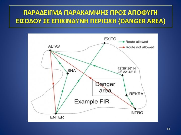
DANGER AREA (ΕΠΙΚΙΝΔΥΝΗ ΠΕΡΙΟΧΗ) «A danger area is an airspace of defined dimensions within which activities dangerous to the flight of aircraft may exist at specified times» . (ICAO Annex 11: Air Traffic Services) Most danger areas are operated by military authorities. The vertical and lateral dimensions of danger areas are published in national AIPs together with the hours of operation where applicable. Danger areas are established around areas where hazardous operations are likely to take place. These include, for example, military exercises involving live firing, parachute dropping, violent and unpredictable aircraft manoeuvers, or the use of unmanned aerial systems(UAS). Examples: LGD 76 KARAVIA, LGD 77 KRANEA 64
TEMPORARY SEGREGATED AREAS (TSA) (ΠΡΟΣΩΡΙΝΑ ΔΕΣΜΕΥΜΕΝΕΣ ΠΕΡΙΟΧΕΣ) CONTROLLED FIRING AREA (ΠΕΔΙΟ ΒΟΛΗΣ) Ø Airspace temporarily reserved and allocated for the exclusive use of a specific user during a determined period of time. Ø ΠΕΔΙΟ ΒΟΛΗΣ ΚΡΗΤΗΣ: LGC 101 CRETAN SEA 65