07 11 12 Glaciation and O S maps


- Slides: 18
07. 11. 12 Glaciation and O. S maps Learning Outcome To identify features on a map
Glaciation and O. S maps When looking for evidence of glaciation look specifically at the contour lines. Contour lines that are very close together, shows steep land (which is particularly important in glaciation, as most features have steep sides) Curved contour lines show corries, also shown on O. S maps (sometimes) as Coire or Cwm. Often with blue inside showing a corrie loch/tarn. 2 Corries back to back show an arete 3 corries back to back show a pyramidal peak Two areas of steep land, with an area of flat land (shown by the white of the map) in between is a U-shaped valley.
Identifying a Glacial Trough on an O. S. map Misfit stream Steep valley sides – notice closeness of the contours Straight, parallel valley sides ‘Whiteness’ on map due to flat valley floor
Identifying a Corrie on an O. S. map • Since a corrie is an ‘armchair shaped’ hollow, on the map you are looking for a horseshoe contour shape. • Tarns / lochans may also be found within the ‘horseshoe’. • Names may also help, such as coire, cwm, cirque, cove and corrie, which may be written on the map. Tarn/lochan Horseshoe shape Name
Identifying an Arête on an O. S. map • On an O. S. map, an arête is always between two corries, the land has contours close together and the highest land is in the middle. Sometimes the symbol for bare rock appears. Corrie Arête Corrie Bare rock Corrie
Identifying a Pyramidal Peak on an O. S. map • To identify a pyramidal peak, look for a spot height or a triangulation station, with three or more corries surrounding it. Arêtes Pyramidal Peak Corrie
Identifying a Hanging Valley on an O. S. map • Look for a U Shaped Valley first, then try to look for a small valley ‘hanging’ above the main valley floor maybe with a waterfall. Tributary valley above main valley Waterfall – water flows down steep valley side Glacial Trough
Corrie Remember! Contour lines are very close together showing very steep land. Arete The contour lines are curved showing a bowl-shape Sometimes a tarn is evident U-Shaped Valley Where two corries form back to back. Contour lines are very close together showing very steep land. There is a long strip of white in the middle showing flat land. The arete (ridge) is shown as a black rugged line
Corrie Llyn, Tarn = Lake Cwm, Coire
U Shaped Valley
Arete • Crib = Ridge on some maps.
Pyramidal Peak
Hanging Valley
Misfit Stream/Ribbon Lake
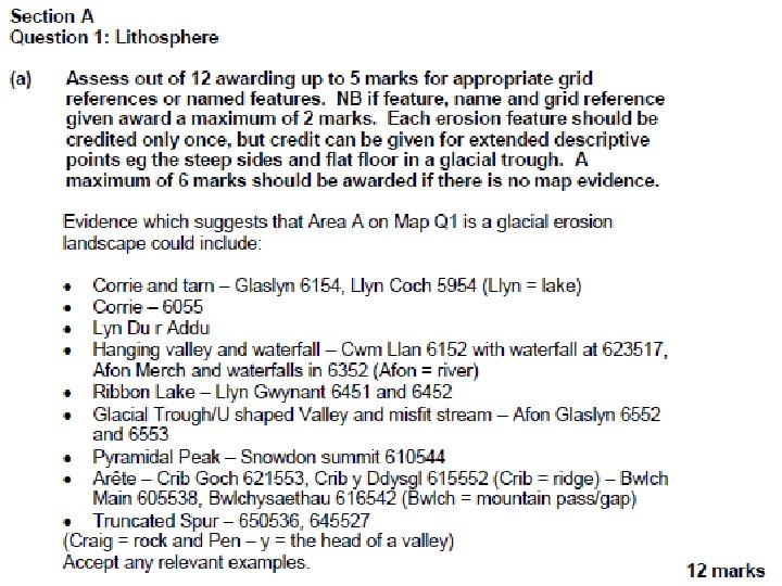
2012 Lithosphere
Higher Map 2012 • Corrie Llyn Cwn at 636588 • Pyramidal Peak at Snowdon Summit 610543 spot height 1085. • Hanging Valley/Waterfall called Afon Merch at 6352. • U Shaped Valley Afon Glaslyn at 652530. • Other features to spot include Misfit Stream, Ribbon Lake, Arete, Truncated Spurs
2001 Map • Hydros and Lith Questions: • Using appropriate grid references, describe the physical characteristics of the River Afon Dysynni and its valley from 710094 to 608050 (6 marks). • Identify features of glacial erosion and give their grid references (4 marks).